Items Similar to British Empire Exhibition 1924 Wembley map by Stanley Kennedy North

Want more images or videos?
Request additional images or videos from the seller
1 of 10
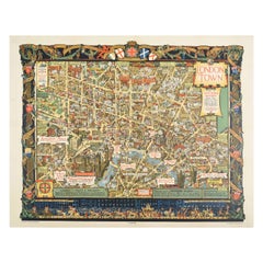
Stanley Kennedy NorthBritish Empire Exhibition 1924 Wembley map by Stanley Kennedy North1924
1924
$475.72
£350
€409.78
CA$666.35
A$731.22
CHF 378.60
MX$8,753.30
NOK 4,749.87
SEK 4,468.71
DKK 3,060.87
About the Item
To see more, scroll down to "More from this Seller" and below it click on "See all from this Seller."
Stanley Kennedy North (1887 - 1942)
British Empire Exhibition Map (1924)
Lithograph
51 x 75 cm
This fascinating and attractive map with elaborate cartouche highlights the attractions of the British Empire Exhibition, a showcase held in London to exhibit the fruits of Britain's overseas colonies. It was designed to boost support for the Empire's activities, encourage trade of imperial goods, and remind other world powers of Britain's (historic) colonial capacity. The Empire Stadium was built especially to house the exhibition; it is known today as Wembley Stadium. The exhibition was opened by King George V on St George's Day, 1924.
- Creator:Stanley Kennedy North (1887 - 1942, British)
- Creation Year:1924
- Dimensions:Height: 20.08 in (51 cm)Width: 29.53 in (75 cm)
- Medium:
- Period:
- Framing:Framing Options Available
- Condition:Generally good; folds as issued; a few short tears at corners.
- Gallery Location:London, GB
- Reference Number:1stDibs: LU795313646092
About the Seller
4.8
Vetted Professional Seller
Every seller passes strict standards for authenticity and reliability
Established in 2014
1stDibs seller since 2017
359 sales on 1stDibs
Typical response time: 6 hours
- ShippingRetrieving quote...Shipping from: London, United Kingdom
- Return Policy
Authenticity Guarantee
In the unlikely event there’s an issue with an item’s authenticity, contact us within 1 year for a full refund. DetailsMoney-Back Guarantee
If your item is not as described, is damaged in transit, or does not arrive, contact us within 7 days for a full refund. Details24-Hour Cancellation
You have a 24-hour grace period in which to reconsider your purchase, with no questions asked.Vetted Professional Sellers
Our world-class sellers must adhere to strict standards for service and quality, maintaining the integrity of our listings.Price-Match Guarantee
If you find that a seller listed the same item for a lower price elsewhere, we’ll match it.Trusted Global Delivery
Our best-in-class carrier network provides specialized shipping options worldwide, including custom delivery.More From This Seller
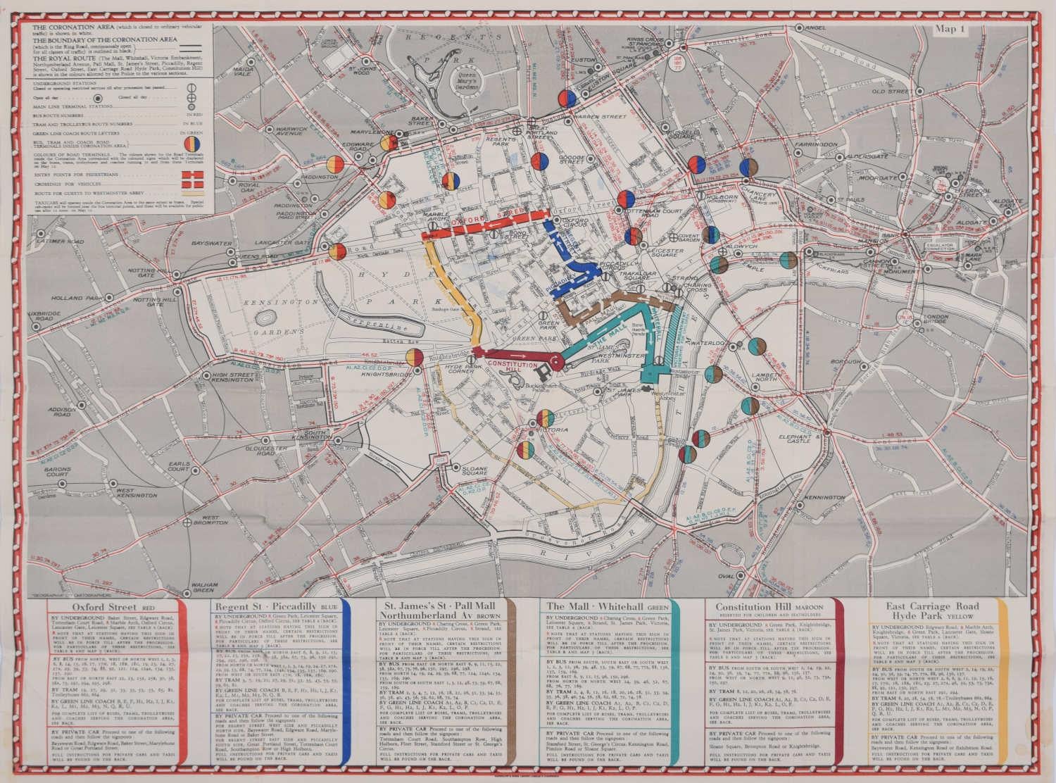
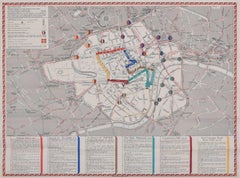
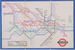
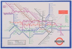
View All1937 Coronation Map for London Transport
Located in London, GB
To see more, scroll down to "More from this Seller" and below it click on "See all from this Seller."
Coronation Arrangements – Map of London (1...
Category
1950s Landscape Prints
Materials
Lithograph
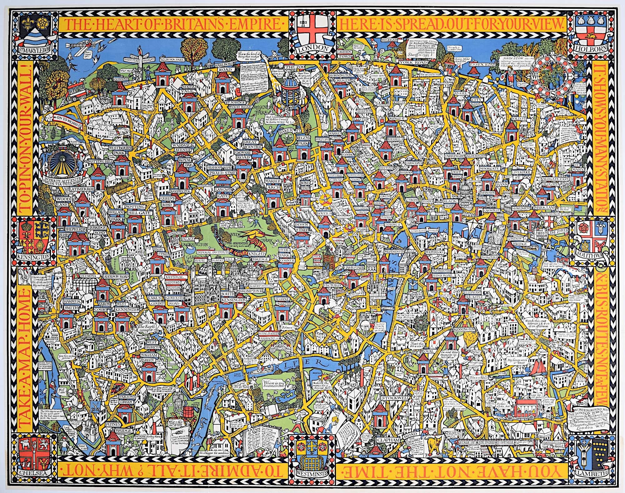
Wonderground Map of London by MacDonald 'Max' Gill c. 1924 original poster
By "Leslie MacDonald ""Max"" Gill"
Located in London, GB
To see our other original vintage posters and views of London (including original paintings), scroll down to "More from this Seller" and below it click on "See all from this Seller" ...
Category
1920s Modern Landscape Prints
Materials
Lithograph
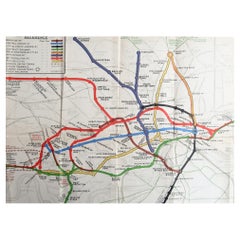
January 1927 London Underground Pocket Map Fred Stingemore pre Harry Beck
Located in London, GB
To see our other original vintage travel posters including more London Transport posters, scroll down to "More from this Seller" and below it click on "See all from this Seller" - or send us a message if you cannot find the poster you want.
Fred Stingemore (1890-1954)
London Underground Railways Pocket Map
January 1927
Lithograph, linen-based card
Bi-fold pocket map
12.5 x 15 cm (unfolded)
Stingemore spent forty years in the London Transport drawing office, but is best known as the artist behind the map that preceeded Harry Beck...
Category
1920s Modern More Prints
Materials
Lithograph
H C Beck September 1936 No 2 London Underground Pocket Map Harry Beck
By Harry Beck
Located in London, GB
To see our other original vintage travel posters including more London Transport posters, scroll down to "More from this Seller" and below it click on "See all from this Seller" - or...
Category
1930s Modern More Prints
Materials
Lithograph
1938 No 2 London Underground Pocket Map 'Zero' Hans Schleger after Harry Beck
By Zero Hans Schleger
Located in London, GB
To see our other original vintage travel posters including more London Transport posters, scroll down to "More from this Seller" and below it click on "See all from this Seller" - or send us a message if you cannot find the poster you want.
'Zero' Hans Schleger
London Underground Railways Pocket Map
1938 No. 2
Lithograph
14.5 x 20.5 cm
An early edition of London Transport's iconic map, precursor to all other similar maps of other transport systems worldwide. The 1939 edition was designed by Hans Schleger, unlike the 1933 - first published - edition of Harry Beck...
Category
1930s Modern More Prints
Materials
Lithograph
H C Beck September 1933 London Underground Pocket Map (First Year of Issue)
By Harry Beck
Located in London, GB
To see our other original vintage travel posters including more London Transport posters, scroll down to "More from this Seller" and below it click on "See all from this Seller" - or...
Category
1930s Modern More Prints
Materials
Lithograph
You May Also Like
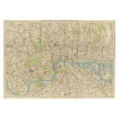
Original Antique Map of The London Underground. 1911
Located in St Annes, Lancashire
Superb map of The London Underground
Published by Ward Lock, 1911
Folding map. Printed on paper
Unframed.
Good condition/ Minor repair to an edge tear on right edge ( shown in ...
Category
Vintage 1910s English Maps
Materials
Canvas, Paper
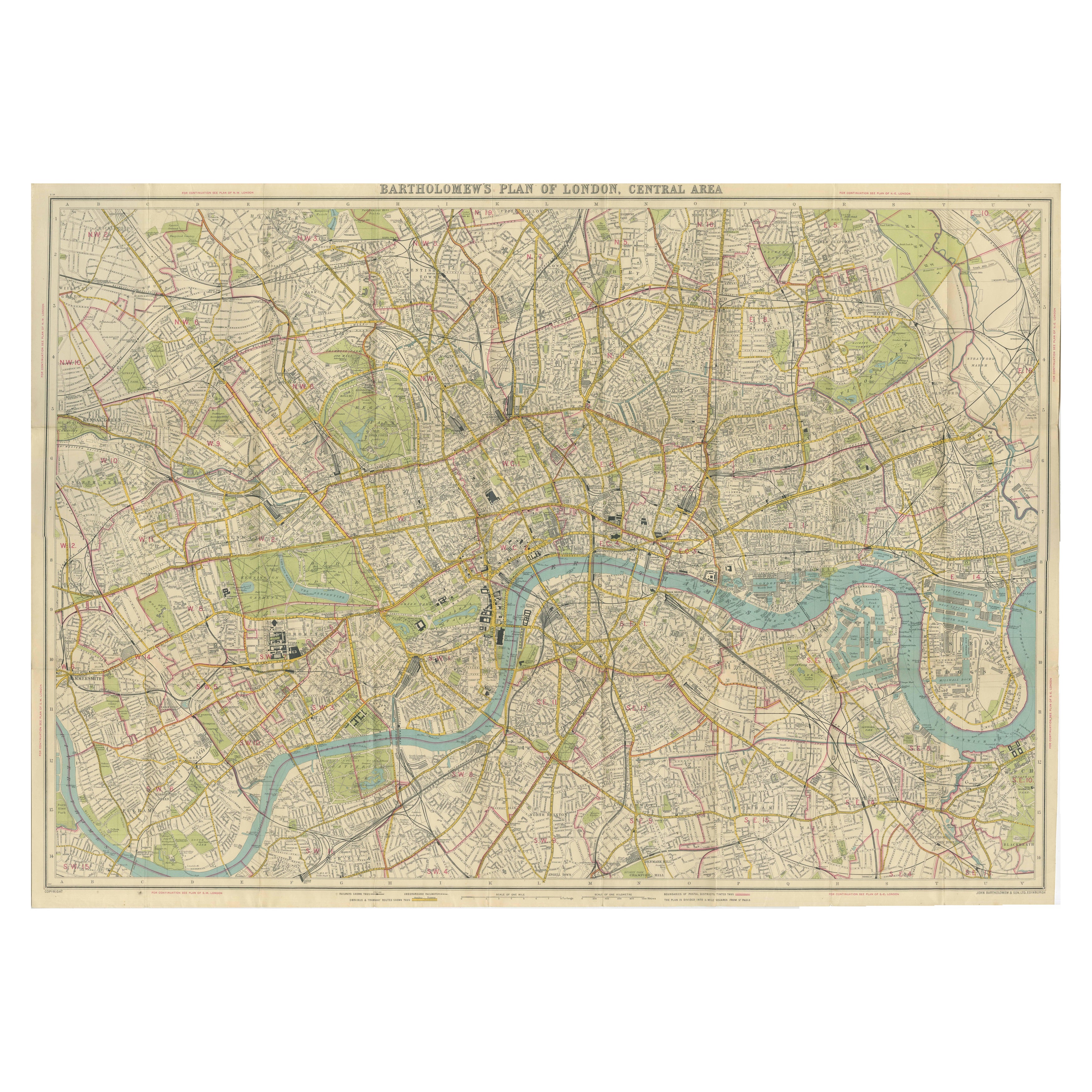
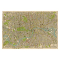
Vintage Map of London – Bartholomew’s Plan of Central London, c.1929
Located in Langweer, NL
London Central Map c.1929 – Bartholomew Antique City Plan
This detailed city plan, titled “Bartholomew’s Plan of London, Central Area,” was published by John Bartholomew & Son, Edin...
Category
Early 20th Century Scottish Maps
Materials
Paper
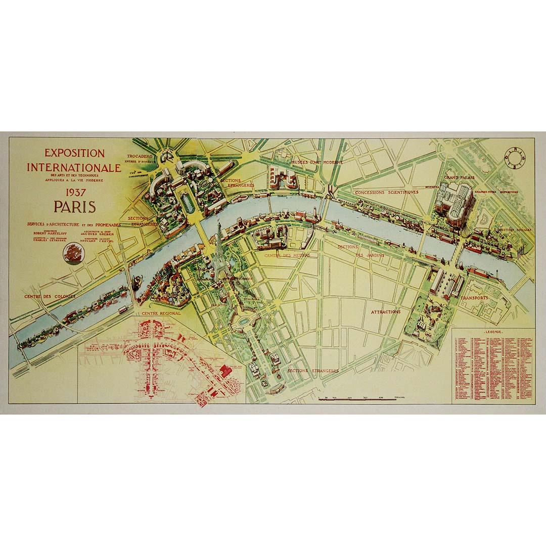
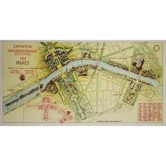
1937 original poster illustrated map of the Exposition Internationale
Located in PARIS, FR
This 1937 original poster presents a detailed illustrated map of the Exposition Internationale des Arts et Techniques dans la Vie Moderne, held in Paris. The International Exposition...
Category
1930s Prints and Multiples
Materials
Linen, Paper, Lithograph
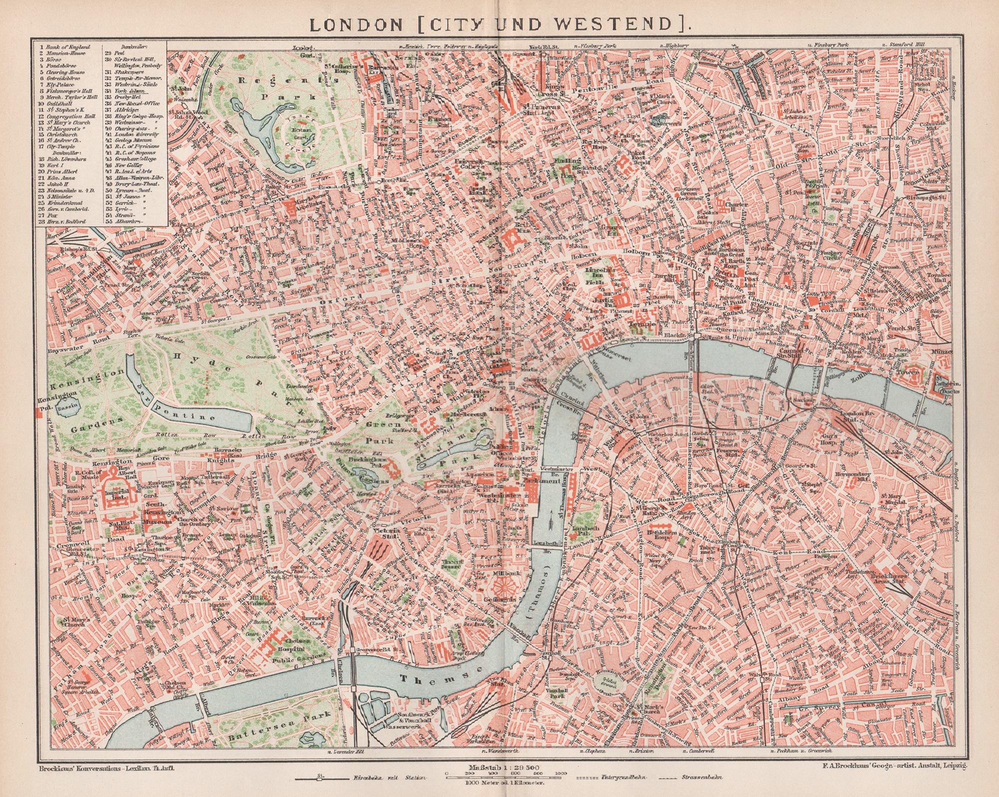
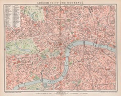
London, City and West End. Antique Map City Plan Chromolithograph, circa 1895
Located in Melbourne, Victoria
'London (City Und Westend)'
Colour lithograph. 1895.
250mm by 305mm (sheet).
Late 19th century German lithograph plan of London, City and West End.
Central vertical fold.
Category
Late 19th Century Victorian More Prints
Materials
Lithograph
Vintage Map of London – Phillips’ Tape Indicator Map of Central London, c.1930
Located in Langweer, NL
Phillips Tape Indicator Map of London c.1930 – Antique City Plan
This large and detailed map of central London is titled “Phillips’ Tape Indicator Map of London.” It was published b...
Category
Early 20th Century Scottish Maps
Materials
Paper
Original Vintage Poster London Town Pictorial Map Southern Railway Underground
By Kerry Lee
Located in London, GB
Original vintage Travel By Train map poster for London Town by the British artist, illustrator and poster designer Kerry Lee (1902-1988) featuring a detailed...
Category
Vintage 1930s British Posters
Materials
Paper
More Ways To Browse
British Empire
Stanley Antique
King George V
British Empire Map
African American Poster
Altman Luxembourg Lithograph
Ana Popescu
Aquatint India
Bernard Buffet Canal
Bernard Cathelin On Sale
Camilla Vintage Prints
Charon Lithograph
Childe Hassam Etching
Christo Running Fence
Christo Surrounded Islands
Christo Wrapped Trees
Eyvind Earle Serigraph
Fairfield Porter Lithograph