Items Similar to 1941 original map "Les vins de Bordeaux - Entre-deux-mers, Graves... " by Larmat
Want more images or videos?
Request additional images or videos from the seller
1 of 8
Louis Larmat1941 original map "Les vins de Bordeaux - Entre-deux-mers, Graves... " by Larmat1941
1941
$1,182.85
£893.26
€1,000
CA$1,654.27
A$1,809.46
CHF 949.56
MX$21,640.17
NOK 11,983.41
SEK 11,179.08
DKK 7,617.53
About the Item
In 1941, French cartographer L. Larmat created a remarkable map titled Atlas de la France Vinicole: Les Vins de Bordeaux - Entre-Deux-Mers, Graves de Vayres, Sainte-Foy Bordeaux, which was printed by Dorel in Paris. This map serves not only as a geographical guide but also as a viticultural reference, capturing the intricate landscape of Bordeaux’s renowned wine regions.
The map emerged during a tumultuous time in France’s history, marked by the upheaval of World War II. Despite the challenges of wartime, the Bordeaux wine industry demonstrated remarkable resilience, and Larmat's work beautifully illustrates the enduring significance of viticulture in the region. Bordeaux, with its rich heritage dating back centuries, has long been recognized as one of the oldest and most prestigious wine-producing areas in the world. This map documents that heritage while providing a snapshot of wine production just before the significant changes that would follow in the post-war era.
Larmat’s map is characterized by its meticulous attention to detail, showcasing the various wine appellations within Bordeaux, specifically highlighting the areas of Entre-Deux-Mers, Graves de Vayres, and Sainte-Foy Bordeaux. Each region is marked with vineyard locations, illustrating the distribution of grape varieties and the unique terroirs that contribute to the distinctive character of Bordeaux wines. The map also includes important topographical features such as rivers, roads, and cities, which are crucial for understanding the geography of wine production. The Garonne and Dordogne rivers, for instance, play a significant role in shaping the climate and soil composition, influencing the types of grapes grown.
The use of color throughout the map enhances its visual appeal and aids in distinguishing between the different wine regions, making it easier for readers to navigate and comprehend the complexity of Bordeaux’s wine landscape.
Larmat’s map has since become a valuable resource for wine enthusiasts, historians, and collectors alike. It encapsulates the essence of Bordeaux's viticultural identity while serving as a historical document that reflects the practices and regions of wine production at the time. The precise delineation of these wine areas provides insight into traditional practices and the evolution of vineyard locations, which continues to inform current winemakers and historians.
Additionally, the map promotes Bordeaux wines on an international scale. By clearly identifying the distinct regions and their characteristics, it educates wine lovers about the unique qualities of Bordeaux wines, encouraging exploration and appreciation of this celebrated viticultural region.
Ultimately, L. Larmat's Atlas de la France Vinicole: Les Vins de Bordeaux - Entre-Deux-Mers, Graves de Vayres, Sainte-Foy Bordeaux stands as a testament to the rich history and culture surrounding Bordeaux wines. As both a historical artifact and a practical guide, this 1941 map continues to inspire interest and admiration for one of the world’s most renowned wine regions. Its detailed representation of the terroirs, along with the historical context of its creation, makes it an essential piece for anyone interested in the heritage of French viticulture.
Original Poster
Alcohol - Map - Gironde - France
Dorel - Paris
- Creator:Louis Larmat
- Creation Year:1941
- Dimensions:Height: 25.6 in (65 cm)Width: 17.72 in (45 cm)
- Medium:
- Period:
- Condition:Good condition, original folds.
- Gallery Location:PARIS, FR
- Reference Number:1stDibs: LU1792215263922
About the Seller
5.0
Gold Seller
Premium sellers maintaining a 4.3+ rating and 24-hour response times
Established in 2021
1stDibs seller since 2022
193 sales on 1stDibs
Typical response time: 3 hours
- ShippingRetrieving quote...Shipping from: PARIS, France
- Return Policy
More From This Seller
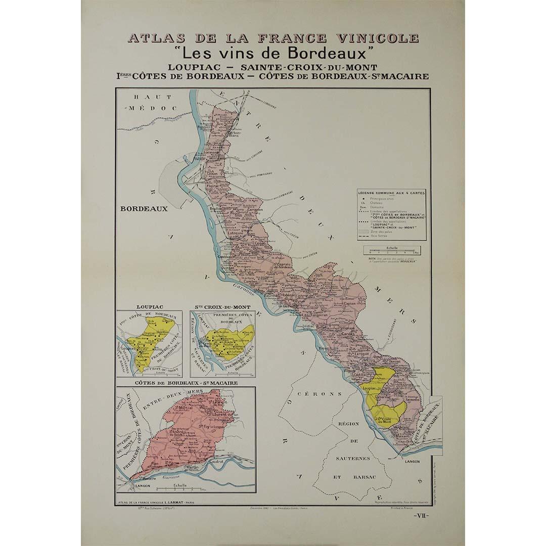
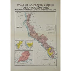
View All1941 original map "Les vins de Bordeaux - Loupiac, ..." by Larmat
Located in PARIS, FR
In 1941, L. Larmat crafted an exquisite map titled Atlas de la France Vinicole: Les Vins de Bordeaux - Loupiac, Sainte-Croix-du-Mont, Ières Côtes de Bordeaux, Côtes de Bordeaux St. M...
Category
1940s Prints and Multiples
Materials
Paper, Lithograph
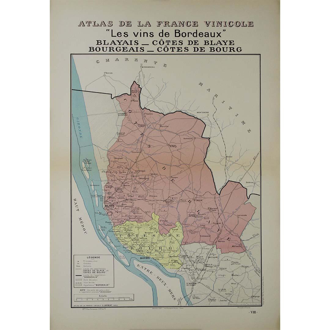
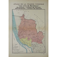
1941 original map "Les vins de Bordeaux - Blayais, Côtes de Blaye" by Larmat
Located in PARIS, FR
In 1941, L. Larmat created an impressive map titled Atlas de la France Vinicole: Les Vins de Bordeaux - Blayais, Côtes de Blaye, Bourgeais, Côtes de Bourg, printed by Dorel in Paris....
Category
1940s Prints and Multiples
Materials
Paper, Lithograph
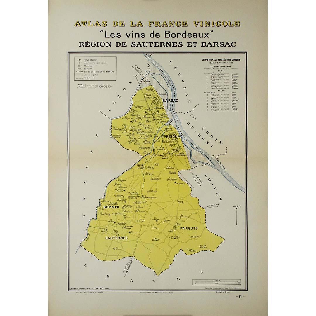
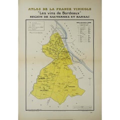
1941 original map "Les vins de Bordeaux - Régions de Sauternes" by Larmat
Located in PARIS, FR
The 1941 original map by L. Larmat, titled "Atlas de la France vinicole – Les vins de Bordeaux: Régions de Sauternes et Barsac", provides an intricate and precise depiction of two of...
Category
1940s Prints and Multiples
Materials
Paper, Lithograph
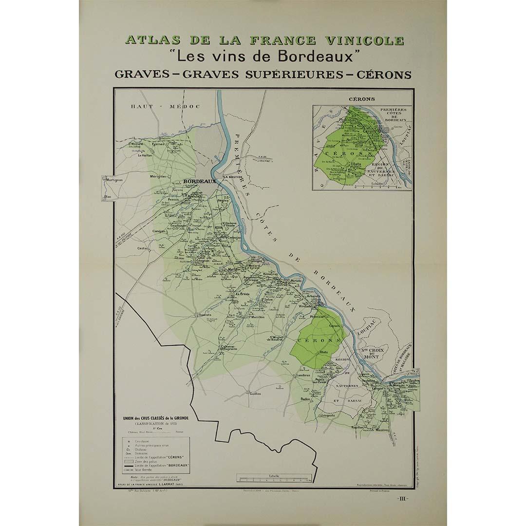
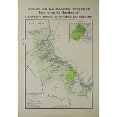
1941 original map "Les vins de Bordeaux - Graves, Graves supérieurs" by Larmat
Located in PARIS, FR
The 1941 original map by L. Larmat, titled "Atlas de la France vinicole – Les vins de Bordeaux: Graves, Graves Supérieurs, Cérons", is a significant contribution to the series that s...
Category
1940s Prints and Multiples
Materials
Paper, Lithograph
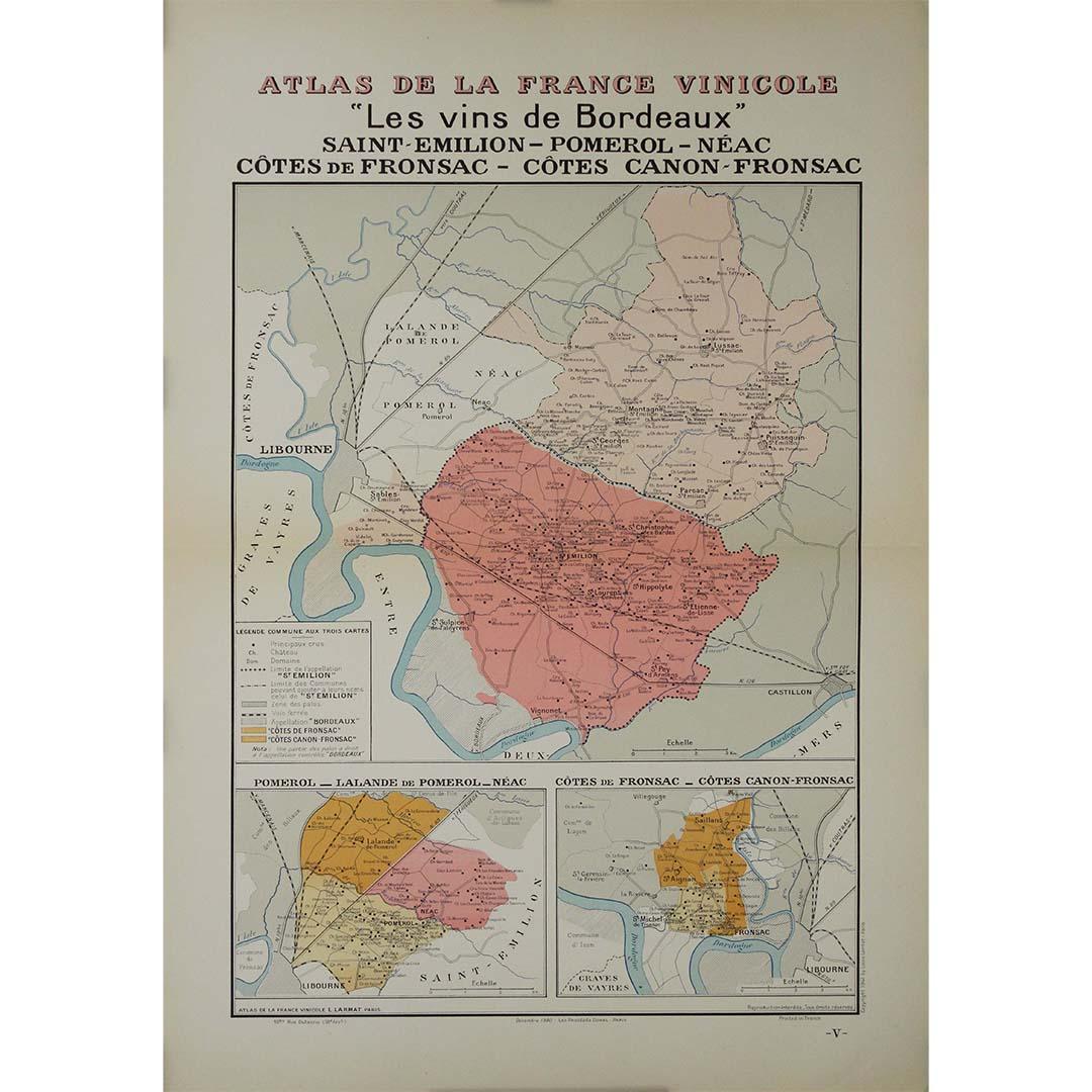
1941 original map "Les vins de Bordeaux - Saint-Émilion, Pomerol..." by Larmat
Located in PARIS, FR
The 1941 original map by L. Larmat, titled "Atlas de la France vinicole – Les vins de Bordeaux: Saint-Émilion, Pomerol, Néac, Côtes de Fronsac, Côtes Canon-Fronsac", offers a detaile...
Category
1940s Prints and Multiples
Materials
Paper, Lithograph

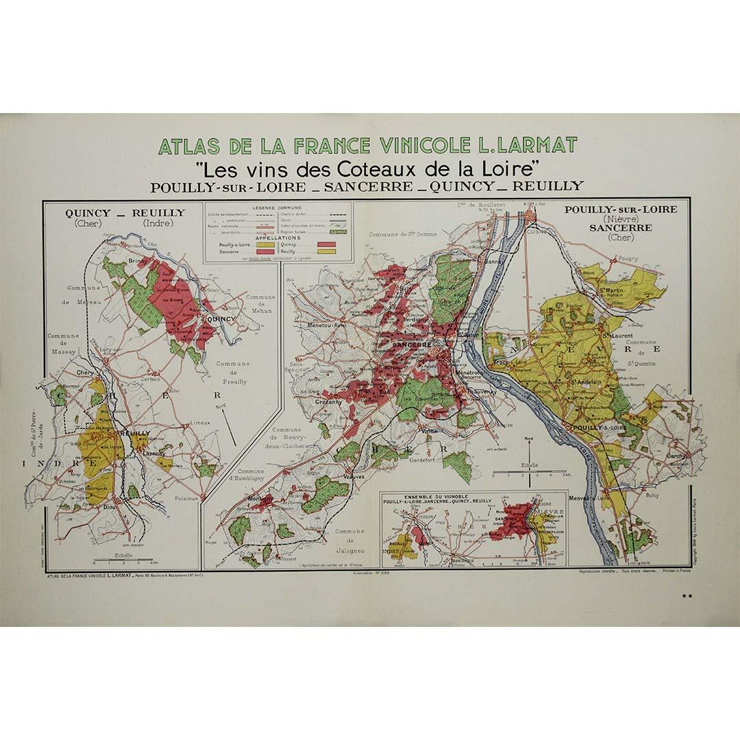
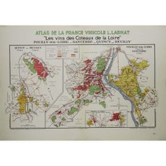
1946 original map "Les vins des côteaux de la Loire - Pouilly-sur-Loire" Larmat
Located in PARIS, FR
The 1946 original map Atlas de la France Vinicole - Les Vins des Côteaux de la Loire: Pouilly-sur-Loire, Sancerre, Quincy, Reuilly, created by Louis Larmat and printed by Dorel in Pa...
Category
1940s Prints and Multiples
Materials
Paper, Lithograph
You May Also Like
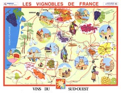
Original Vins du Sud-Ouest vintage French wine map poster
Located in Spokane, WA
Original Les Vignobles de France , Vins du Sud-Quest French vintage wine map poster. Horizontal. Size 36.5" x 27". Archival linen backed and re...
Category
Late 20th Century American Modern Landscape Prints
Materials
Lithograph
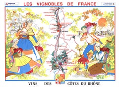
Original Vins Des Côtes du Rhône, French Wine Map vintage poster
Located in Spokane, WA
Original Les Vignobles de France - Cote du Rhone vintage wine map poster. Horizontal. Size 36.5" x 27". Archival linen backed and ready to fram...
Category
Late 20th Century American Modern Landscape Prints
Materials
Lithograph
$600 Sale Price
20% Off
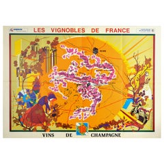
Original Vintage Poster Vineyards Of Champagne Wine Map Les Vignobles De France
Located in London, GB
Original vintage advertising poster for Les Vignobles de France Vins de Champagne / The Vineyards of France Wines of Champagne featuring a pictogra...
Category
Vintage 1960s French Posters
Materials
Paper
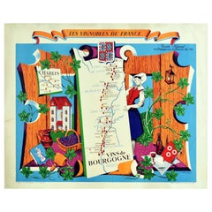
Original Vintage Poster Vignobles De France Vins De Bourgogne Burgundy Wine Map
Located in London, GB
Original vintage drink advertising poster promoting French wines (one of a series issued by the Comite National de Propagande en Faveur du Vin national committee for the promotion of...
Category
Vintage 1950s French Posters
Materials
Paper
Original Vintage Poster Vignobles De France Vins Du Val De Loire Valley Wine Map
Located in London, GB
Original vintage drink advertising poster promoting French wines (one of a series issued by the Comite National de Propagande en Faveur du Vin national committee for the promotion of...
Category
Vintage 1950s French Posters
Materials
Paper
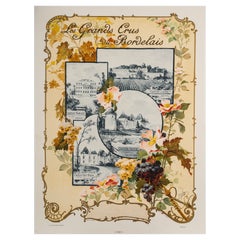
Original Art Nouveau Map, Grands Crus Bordeaux, Lafite, Yquem, Margaux, 1899
Located in SAINT-OUEN-SUR-SEINE, FR
Art Nouveau poster created in 1899 by Géojan to promote the great wines of Bordeaux, namely Château Margaux (Médoc), Château Lafite (Médoc), Château Yquem (Sauternes), Château Haut B...
Category
20th Century French Art Nouveau Posters
Materials
Paper
More Ways To Browse
Vintage French Map
Alcohol Poster
Vintage Alcohol Posters
Bordeaux Wine
Wine Map
Bordeaux Map
David Lemon
Dorothea Rockburne
Edo Period Woodblock
Egon Schiele And Max Jaffe
Erotic 1920
Harriet Tubman
Helen Frankenthaler Lincoln Center Posters
Hercules Print
Homage To Andy Warhol
I Have Been To Hell And Back
Iris Lithograph
Japanese Art Print Flower