Items Similar to 1941 original map "Les vins de Bordeaux - Graves, Graves supérieurs" by Larmat


Want more images or videos?
Request additional images or videos from the seller
1 of 8
Louis Larmat1941 original map "Les vins de Bordeaux - Graves, Graves supérieurs" by Larmat1941
1941
$1,184.13
£888.62
€1,000
CA$1,658.64
A$1,820.11
CHF 942.38
MX$21,788.19
NOK 11,823.09
SEK 11,123.25
DKK 7,618.94
About the Item
The 1941 original map by L. Larmat, titled "Atlas de la France vinicole – Les vins de Bordeaux: Graves, Graves Supérieurs, Cérons", is a significant contribution to the series that showcases France's most prestigious wine regions. Printed by Dorel in Paris, this map provides a meticulous depiction of the Graves region, along with the Graves Supérieurs and Cérons appellations. These areas are well-known within the Bordeaux wine region for their production of both red and white wines, with a particular emphasis on Sauvignon Blanc, Sémillon, and Cabernet Sauvignon.
Published during the trying years of World War II, this map holds historical value, representing the enduring cultural and economic importance of French winemaking in a time of significant upheaval. Graves, located on the Left Bank of the Garonne River, is one of the oldest wine-producing regions in Bordeaux, famous for its well-drained gravelly soils (from which the region gets its name) that contribute to the distinctive character of its wines.
The Graves Supérieurs appellation, designated for sweet white wines, and the Cérons appellation, known for its sweet, botrytized wines, are both included on this map, providing a comprehensive overview of the region’s diversity. Larmat’s map elegantly illustrates the intricate network of vineyards, rivers, and terroirs that contribute to the production of some of the finest wines in Bordeaux. The Graves region is famous for producing both dry white wines and red wines, with the sweet wine appellations of Graves Supérieurs and Cérons being particularly notable for their dessert-style wines.
The Graves region, centered around the historic wine-producing commune of Pessac-Léognan, is home to some of the most prestigious estates in Bordeaux, including the world-renowned Château Haut-Brion, which was classified as a Premier Grand Cru in the 1855 Bordeaux Classification—the only estate outside the Médoc to be included in this prestigious ranking. The map clearly marks the boundaries of key estates, showcasing the intricate geography of the region, including its elevation, proximity to the Garonne River, and other key factors that define its unique terroir.
Larmat’s cartography is both functional and artistic, blending precision with aesthetic appeal. The map features a subtle color palette, using shades of green, yellow, and brown to distinguish between different appellations and vineyard areas. The geographic features of the Graves region, such as its gravelly soils, rolling hills, and proximity to the Garonne River, are all highlighted to give the viewer a deeper understanding of the environmental factors that influence the character of the wines.
One of the standout aspects of the Graves region is its ability to produce age-worthy red wines as well as crisp, aromatic white wines from grape varieties such as Sauvignon Blanc and Sémillon. The dry white wines of Graves, often noted for their minerality and freshness, are highly regarded, and Larmat’s map provides an in-depth look at where these wines are produced. The Graves Supérieurs and Cérons appellations, marked on the map, highlight the regions where sweet, botrytized wines are crafted—wines that share a kinship with the famous Sauternes wines further south.
In addition to offering detailed information on the terroir and geography of the region, Larmat’s map also captures the historical significance of Graves in the broader context of Bordeaux’s winemaking history. The Graves region is often regarded as the birthplace of Bordeaux’s wine industry, with viticulture in the area dating back to Roman times. Larmat’s depiction of the region, therefore, is not only a useful tool for winemakers and wine enthusiasts but also a tribute to the centuries-old traditions that have shaped the identity of Bordeaux’s wines.
Printed by Dorel in Paris, this map is a fine example of early 20th-century French craftsmanship. Despite the challenges of the era, particularly those posed by the war, the quality of the printing and the detail of the cartography remain exceptional. The precise typography, careful shading, and rich detailing of vineyard locations and appellation boundaries make this map both a practical resource and a beautiful work of art. Collectors of Larmat’s Atlas often prize these maps not only for their historical importance but also for their aesthetic value.
The Graves Supérieurs and Cérons appellations, while lesser-known than some of the more famous Bordeaux regions, are celebrated for their sweet white wines, which are often made using grapes affected by noble rot (Botrytis cinerea). These wines are known for their complexity and depth, with rich flavors of honey, apricot, and citrus. Larmat’s map provides a clear guide to where these wines are produced, offering insight into the terroir that makes these wines so special.
This 1941 map of the Graves, Graves Supérieurs, and Cérons regions is an invaluable resource for anyone interested in the history of Bordeaux winemaking. It serves not only as a detailed guide to the region’s geography but also as a historical document that reflects the resilience and enduring importance of French viticulture during one of the most challenging periods in the country’s history. Larmat’s cartography, with its blend of art and science, continues to be highly regarded by collectors, wine historians, and enthusiasts alike.
The map’s combination of detailed geographical information and visual elegance makes it a prized addition to any collection, offering a snapshot of the Bordeaux wine region as it existed in the early 1940s. Today, it remains a valuable tool for understanding the nuances of the Graves region and the broader Bordeaux wine landscape, celebrating the rich heritage of one of France’s most important winemaking areas.
Original Poster
Alcohol - Map - Gironde - France
Dorel - Paris
- Creator:Louis Larmat
- Creation Year:1941
- Dimensions:Height: 25.6 in (65 cm)Width: 17.72 in (45 cm)
- Medium:
- Period:
- Condition:Good condition, original folds.
- Gallery Location:PARIS, FR
- Reference Number:1stDibs: LU1792215263812
About the Seller
5.0
Gold Seller
Premium sellers maintaining a 4.3+ rating and 24-hour response times
Established in 2021
1stDibs seller since 2022
186 sales on 1stDibs
Typical response time: 1 hour
- ShippingRetrieving quote...Shipping from: PARIS, France
- Return Policy
Authenticity Guarantee
In the unlikely event there’s an issue with an item’s authenticity, contact us within 1 year for a full refund. DetailsMoney-Back Guarantee
If your item is not as described, is damaged in transit, or does not arrive, contact us within 7 days for a full refund. Details24-Hour Cancellation
You have a 24-hour grace period in which to reconsider your purchase, with no questions asked.Vetted Professional Sellers
Our world-class sellers must adhere to strict standards for service and quality, maintaining the integrity of our listings.Price-Match Guarantee
If you find that a seller listed the same item for a lower price elsewhere, we’ll match it.Trusted Global Delivery
Our best-in-class carrier network provides specialized shipping options worldwide, including custom delivery.More From This Seller
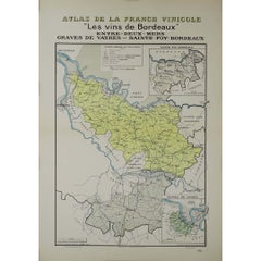
View All1941 original map "Les vins de Bordeaux - Entre-deux-mers, Graves... " by Larmat
Located in PARIS, FR
In 1941, French cartographer L. Larmat created a remarkable map titled Atlas de la France Vinicole: Les Vins de Bordeaux - Entre-Deux-Mers, Graves de Vayres, Sainte-Foy Bordeaux, whi...
Category
1940s Prints and Multiples
Materials
Lithograph, Paper
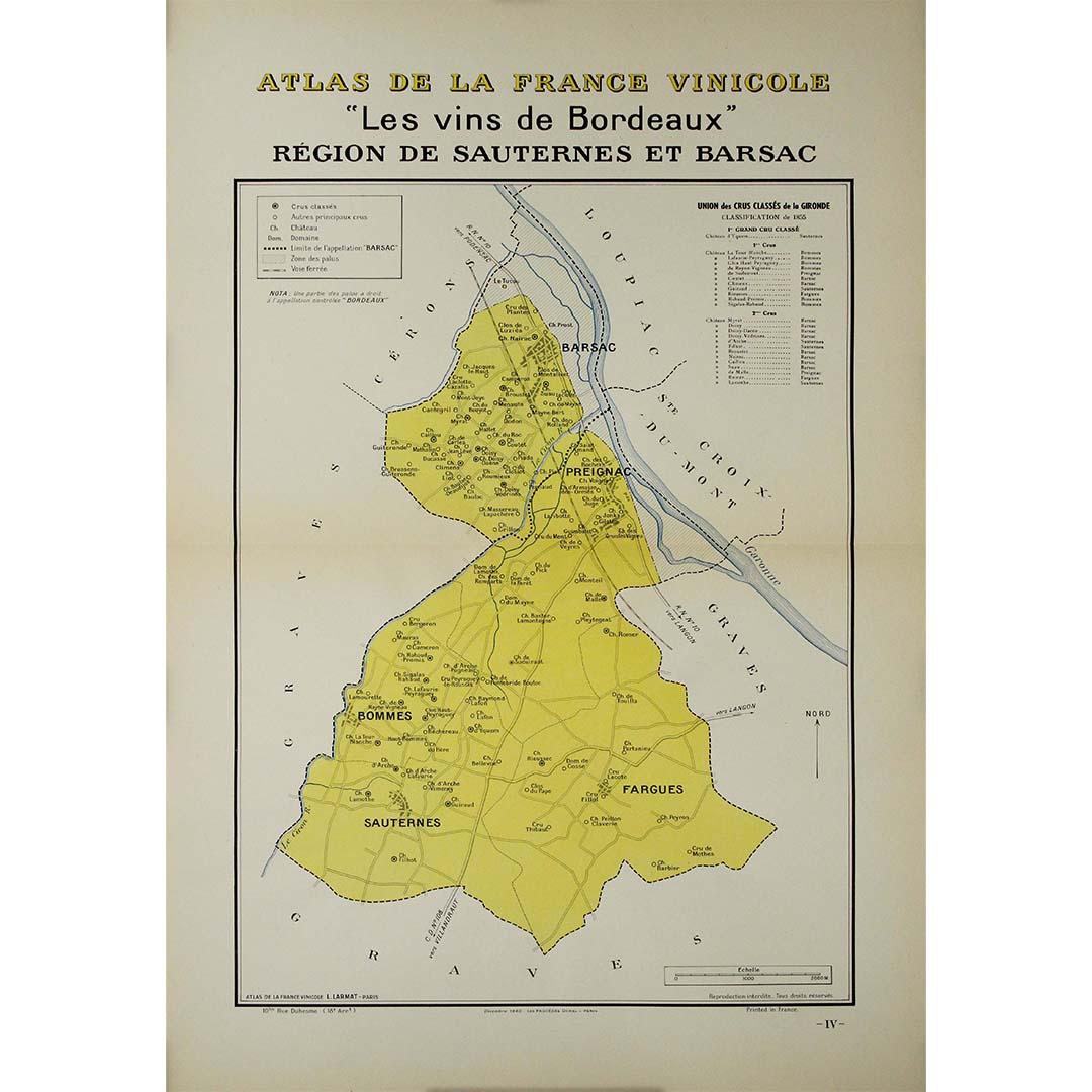
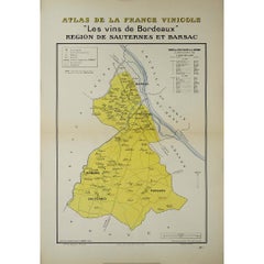
1941 original map "Les vins de Bordeaux - Régions de Sauternes" by Larmat
Located in PARIS, FR
The 1941 original map by L. Larmat, titled "Atlas de la France vinicole – Les vins de Bordeaux: Régions de Sauternes et Barsac", provides an intricate and precise depiction of two of...
Category
1940s Prints and Multiples
Materials
Lithograph, Paper
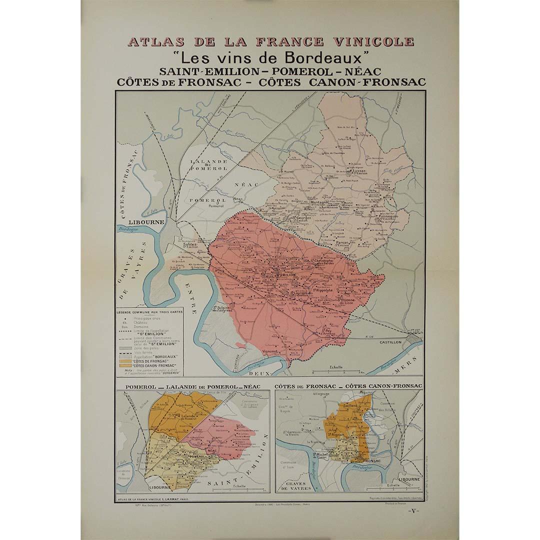
1941 original map "Les vins de Bordeaux - Saint-Émilion, Pomerol..." by Larmat
Located in PARIS, FR
The 1941 original map by L. Larmat, titled "Atlas de la France vinicole – Les vins de Bordeaux: Saint-Émilion, Pomerol, Néac, Côtes de Fronsac, Côtes Canon-Fronsac", offers a detaile...
Category
1940s Prints and Multiples
Materials
Lithograph, Paper

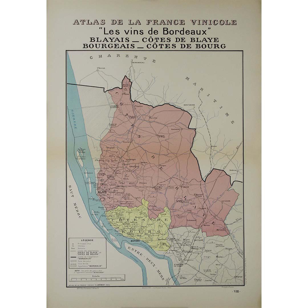
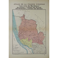
1941 original map "Les vins de Bordeaux - Blayais, Côtes de Blaye" by Larmat
Located in PARIS, FR
In 1941, L. Larmat created an impressive map titled Atlas de la France Vinicole: Les Vins de Bordeaux - Blayais, Côtes de Blaye, Bourgeais, Côtes de Bourg, printed by Dorel in Paris....
Category
1940s Prints and Multiples
Materials
Lithograph, Paper
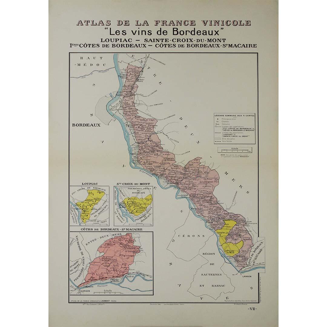
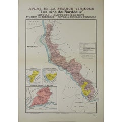
1941 original map "Les vins de Bordeaux - Loupiac, ..." by Larmat
Located in PARIS, FR
In 1941, L. Larmat crafted an exquisite map titled Atlas de la France Vinicole: Les Vins de Bordeaux - Loupiac, Sainte-Croix-du-Mont, Ières Côtes de Bordeaux, Côtes de Bordeaux St. M...
Category
1940s Prints and Multiples
Materials
Lithograph, Paper
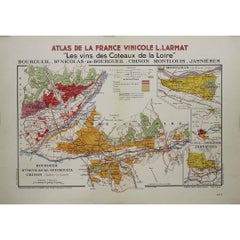
1946 original map "Les vins des côteaux de la Loire - Bourgueil" by Larmat
Located in PARIS, FR
The 1946 original map Atlas de la France Vinicole - Les Vins des Côteaux de la Loire: Bourgueil, St Nicolas-de-Bourgueil, Chinon, Montlouis, Jasnières, created by Louis Larmat and pr...
Category
1940s Prints and Multiples
Materials
Lithograph, Paper
You May Also Like
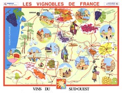
Original Vins du Sud-Ouest vintage French wine map poster
Located in Spokane, WA
Original Les Vignobles de France , Vins du Sud-Quest French vintage wine map poster. Horizontal. Size 36.5" x 27". Archival linen backed and re...
Category
Late 20th Century American Modern Landscape Prints
Materials
Lithograph
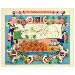
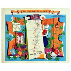
Original Vintage Poster Vignobles De France Vins Du Val De Loire Valley Wine Map
Located in London, GB
Original vintage drink advertising poster promoting French wines (one of a series issued by the Comite National de Propagande en Faveur du Vin national committee for the promotion of...
Category
Vintage 1950s French Posters
Materials
Paper
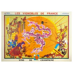
Original Vintage Poster Vineyards Of Champagne Wine Map Les Vignobles De France
Located in London, GB
Original vintage advertising poster for Les Vignobles de France Vins de Champagne / The Vineyards of France Wines of Champagne featuring a pictogra...
Category
Vintage 1960s French Posters
Materials
Paper
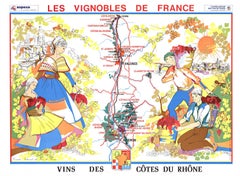
Original Vins Des Côtes du Rhône, French Wine Map vintage poster
Located in Spokane, WA
Original Les Vignobles de France - Cote du Rhone vintage wine map poster. Horizontal. Size 36.5" x 27". Archival linen backed and ready to fram...
Category
Late 20th Century American Modern Landscape Prints
Materials
Lithograph
$600 Sale Price
20% Off
Original Vintage Poster Vignobles De France Vins De Bourgogne Burgundy Wine Map
Located in London, GB
Original vintage drink advertising poster promoting French wines (one of a series issued by the Comite National de Propagande en Faveur du Vin national committee for the promotion of...
Category
Vintage 1950s French Posters
Materials
Paper
Map of Haute Vienne - Original Lithograph - 19th Century
Located in Roma, IT
Map of Haute Vienne is an original lithograph artwork realized by an Anonymous engraver of the 19th century.
Printed in the series of "France Pittoresque".
Titled "France Pittore...
Category
19th Century Modern Figurative Prints
Materials
Lithograph

More Ways To Browse
Vintage French Map
Vintage Illustrated Maps
Alcohol Poster
Vintage Alcohol Posters
Bordeaux Wine
Wine Map
Bordeaux Map
David Lemon
Dorothea Rockburne
Edo Period Woodblock
Egon Schiele And Max Jaffe
Erotic 1920
Harriet Tubman
Helen Frankenthaler Lincoln Center Posters
Hercules Print
Homage To Andy Warhol
I Have Been To Hell And Back
Iris Lithograph