Items Similar to Framed Rubbing of 1550 Brass Monument in Grote Kerk Church, Breda, Netherlands

Want more images or videos?
Request additional images or videos from the seller
1 of 14
UnknownFramed Rubbing of 1550 Brass Monument in Grote Kerk Church, Breda, Netherlands Unknown
Unknown
About the Item
This is an engraving of a tomb monument rubbing that has been highlighted with gold color on a dark grey to black background. The rubbing is of a brass plaque on a stone slab. It has inscriptions along the edges and an angel with a halo holding a chalice and shield. The inscription reads "Hoc saxo tegitur corpus honorabilis viri domini Adriani Roelandi Bartholomei alias Heys, sacellani huius ecclesie, qui obiit Anno Domini 1550 Iulii die septima" (Covered by this stone is the body of the honorable man, Sir Adrianus son of Roelandt Bartholomeus, alias Heys, priest of this church, who died in the year of Our Lord 1550 on the seventh day of July). Along with images of the print in this listing, an image of the actual tomb with the brass plaque is included. The tomb is in the Grote Kerk or Onze-Lieve-Vrouwekerk (Church of Our Lady), which is a prominent landmark in Breda, in the southern portion of the Netherlands. The oldest record of a stone church in Breda is from 1269. The construction of this church was begun in 1410. It was completed in 1457 but the tower collapsed in 1468. The reconstruction of the tower was completed in 1509. Although in use, additional construction projects continued until 1547. The Reformation ended the church as a Catholic place of worship in 1566 and it transitioned to Protestant in 1637.
The print is presented in a distinctive ornate black wood frame with a scalloped gold inner edge or fillet. The deep dark mauve mat is highlighted with a marbled gold fillet. The frame measures 32.25" x 32.5" x 1.5". It can be hung in a square or diamond orientation. The latter orientation places the angel in an upright position and is the orientation of the plaque on the monument. The print is in excellent condition.
- Creation Year:Unknown
- Dimensions:Height: 32.25 in (81.92 cm)Width: 32.25 in (81.92 cm)Depth: 1.5 in (3.81 cm)
- Medium:
- Movement & Style:
- Period:
- Condition:
- Gallery Location:Alamo, CA
- Reference Number:
About the Seller
5.0
Vetted Seller
These experienced sellers undergo a comprehensive evaluation by our team of in-house experts.
Established in 2011
1stDibs seller since 2019
233 sales on 1stDibs
Typical response time: 1 hour
- ShippingRetrieving quote...Ships From: Alamo, CA
- Return PolicyA return for this item may be initiated within 7 days of delivery.
More From This SellerView All
- L'Isle de France: A Hand-colored 17th Century Map by De WitBy Frederick de WitLocated in Alamo, CAThis colorful and detailed 17th century hand-colored copperplate map by Frederick De Wit was published in Amsterdam between 1666 and 1760. The map depicts the Île-de-France, which is one of the ancient provinces of France. Paris is located in the center of the map, with Versailles to the southwest The map extends from Rouen in the west to Reims in the east. The area around Paris, the Véxin Français, was the original domain of the king of France. Other areas were ruled by French feudal lords. For example, the Véxin Normand area was the domain of the Duke of Normandy...Category
Early 18th Century Old Masters More Prints
MaterialsEngraving
- Map of the Russian Empire: An Original 18th Century Hand-colored Map by E. BowenLocated in Alamo, CAThis is an original 18th century hand-colored map entitled "A New & Accurate Map of The Whole Russian Empire, As Contain'd Both In Europe and Asia, Drawn from Authentic Journals, Sur...Category
Mid-18th Century Old Masters Landscape Prints
MaterialsEngraving
- Ulysses Deriding Polyphemus: A Framed 19th C. Engraving After J. M. W. TurnerBy J.M.W. TurnerLocated in Alamo, CAThis beautiful 19th century framed hand-colored engraving/etching entitled "Ullyses Deriding Polyphemus" by Edward Goodall is based on an original 1829 painting by the renowned Briti...Category
Mid-19th Century Romantic Landscape Prints
MaterialsEngraving, Etching
- View of Emden, Germany: A 16th Century Hand-colored Map by Braun & HogenbergBy Franz HogenbergLocated in Alamo, CAThis is a 16th century original hand-colored copperplate engraved map of a bird's-eye View of Embden, Germany entitled " Emuda, vulgo Embden vrbs Frisia orientalis primaria" by Georg Braun & Franz Hogenberg, in volume II of their famous city atlas "Civitates Orbis Terrarum", published in Cologne, Germany in 1575. This is a beautifully colored and detailed map of Emden, a seaport in northwestern Germany, along the Ems River and perhaps portions of over Dollart Bay, near the border with the Netherland. The map depicts a bird's-eye view of the city from the southwest, as well as a view of the harbor and an extensive system of canals. Numerous ships of various sizes, as well as two rowboats containing numerous occupants are seen in the main waterway in the foreground and additional boats line two canals in the center of the city. Two men and two women are shown on a hill in the foreground on the right, dressed in the 16th century style of nobility. Two ornate crests are included in each corner. A title strap-work cartouche is in the upper center with the title in Latin. The crest on the right including Engelke up de Muer (The Little Angel on the Wall) was granted by Emperor Maximilian I in 1495. This is an English translation of an excerpt of Braun's description of Embden: "In Emden, the capital of East Frisia, rich merchants live in very fine houses. The city has a broad and well-situated harbour, which in my opinion is unique in Holland. Frisia and the whole of the Netherlands, for the ships can anchor here right under the city walls. They have also extended the harbour as far as the New Town, so that up to 400 ships can now find shelter here when the sea is rough." The emphasis on the harbor and waterways within the city highlights the importance of Emden's place as a seaport at this time. Embden developed from a Dutch/Flemish trading settlement in the 7th-8th centuries into a city as late as late 14th century. In 1494 it was granted staple rights, and in 1536 the harbour was extended. In the mid-16th century Emden's port was thought to have the most ships in Europe. Its population then was about 5,000, rising to 15,000 by the end of the 16th century. The Ems River flowed directly under the city walls, but its course was changed in the 17th century by the construction of a canal. Emden has canals within its city limits, a typical feature of Dutch towns, which also enabled the extension of the harbor. In 1744 Emden was annexed by Prussia and is now part of Germany. It was captured by French forces in 1757 during the Seven Years' War, but recaptured by Anglo-German forces in 1758. During the Napoleonic French era, Emden and the surrounding lands of East Frisia were part of the short-lived Kingdom of Holland. References:Van der Krogt 4, 1230, State 2; Taschen, Braun and Hogenberg...Category
16th Century Old Masters Landscape Prints
MaterialsEngraving
- Ireland: A Framed 17th Century Hand-colored Map by Jan JannsonBy Johannes JanssoniusLocated in Alamo, CAThis is a 17th century hand-colored map entitled "Hibernia Regnum Vulgo Ireland" by Johannes Janssonius's (Jan Jansson), published in Amsterdam in 1640. This highly detailed map depicts the Emerald Isle with an extensive display of towns, roads, mountains, rivers, lakes and county borders, etc. It includes two decorative cartouches on the left. The title cartouche includes the Irish harp and the second, in the upper left, includes a lion wearing a crown on the left, a unicorn on the right and a coat-of-arms in the middle, which includes another Irish harp. A distance scale is seen in the lower right, augmented with two putti. The map is embellished with three sailing ships and a sea monster. Western portions of Scotland and England...Category
Mid-17th Century Old Masters Landscape Prints
MaterialsEngraving
- View of Meissen, Germany: A 16th Century Hand-colored Map by Braun & HogenbergBy Franz HogenbergLocated in Alamo, CAThis is a 16th century original hand-colored copperplate engraved map of View of View of Meissen, Germany entitled "Misena Hermun Duvorum Urbs" by Georg Braun & Franz Hogenberg, from their famous city atlas "Civitates Orbis Terrarum", published in Cologne, Germany in 1575. The map depicts a side view and bird's-eye view, looking across the Elbe River (labelled Albis Fluvius on the map; White River in Latin) from the northeast. In the foreground are three women in conversation on a hill above the city, along with a man and a woman in conversation by a road, all dressed in contemporary costumes of the upper class. A coat-of-arms is present in each upper corner. A great castle sits atop a hill in the background on the left. Meissen grew up around Albrechtsburg castle, built by Emperor Henry I around AD 929, and was granted a municipal charter at the end of the 12th century. From 1471 onwards, the castle complex was reconstructed as the residence of the Saxon electors on the northeast corner of the Domberg (Cathedral Hill). Meissen cathedral is a Gothic hall church begun c. 1270; in 1413 a bolt of lightning destroyed its west towers, which were replaced only in the 20th century. Meissen lies to the northwest of Dresden, Germany in Saxony. Meissen is famous for its Meissen porcelain and the Albrechtsburg castle The following is an English translation of an excerpt from Braun's description of the city: "This city is surrounded by very many rivers, to the east flows the Elbe, to the south the Triebisch, to the west are the mountains, to the north the Meisse, after which the city is said to be named. The city is well-situated in its surroundings, the navigable rivers, the mountains and the healthy air. Around the city there is a good land to grow grain, fertile vineyards on the hillsides and without doubt the mountains are not without ore, for one mile away, up the Elbe, is Scharfenberg, where silver and lead ore are mined.." References: Van der Krogt 4, 2684; Taschen, Braun and Hogenberg...Category
16th Century Old Masters Landscape Prints
MaterialsEngraving


You May Also Like
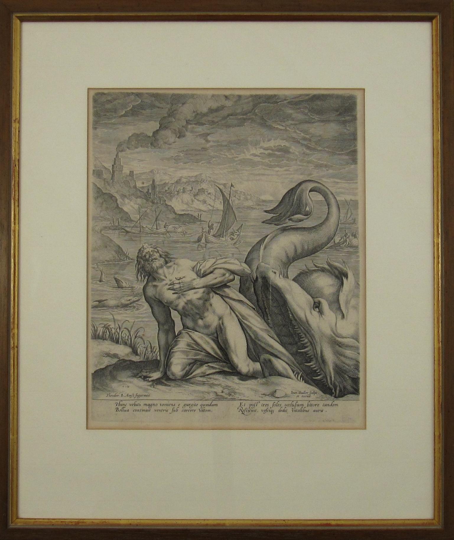
- Johannes Sadeler I (Flemish 1550-1600) – Engraving 1582 - Jonah and the Whale IIBy Johannes Sadeler ILocated in Meinisberg, CHJohannes Sadeler I (Flemish, ∗ 1550 in Brussels, Belgium – † 1600 Venice, Italy) Jonah Spat Up by the Whale (Sheet II) Engraved by Sadeler after an image created by Theodor Bernard...Category
16th Century Renaissance Figurative Prints
MaterialsLaid Paper, Engraving
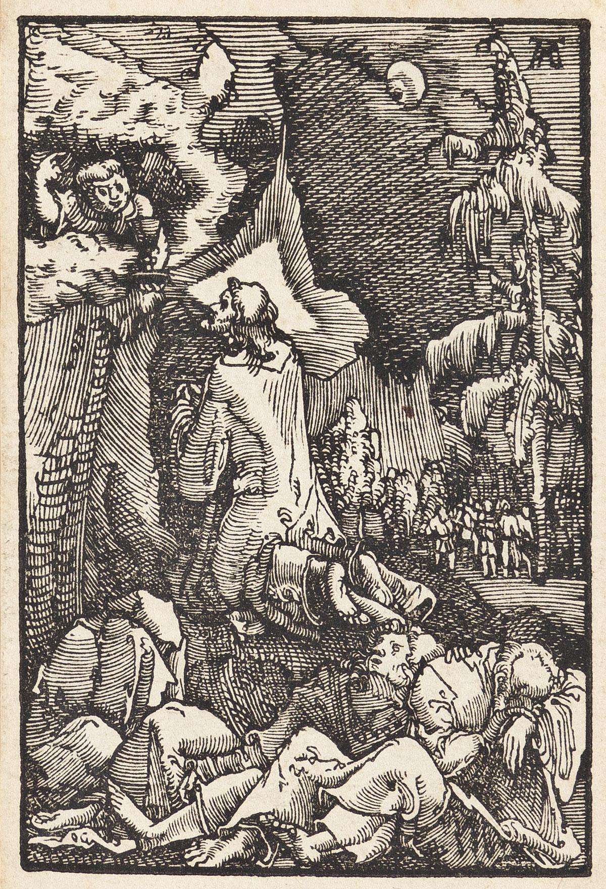
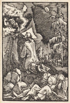
- Christ on the Mount of OlivesBy Albrecht AltdorferLocated in New York, NYA brilliant and early impression of this woodcut. Dark, well-inked, with strong contrasts and no sign of wear. From "The Fall and Salvation of Mankind Through the Life and Passion of Christ."Category
16th Century Renaissance Figurative Prints
MaterialsWoodcut
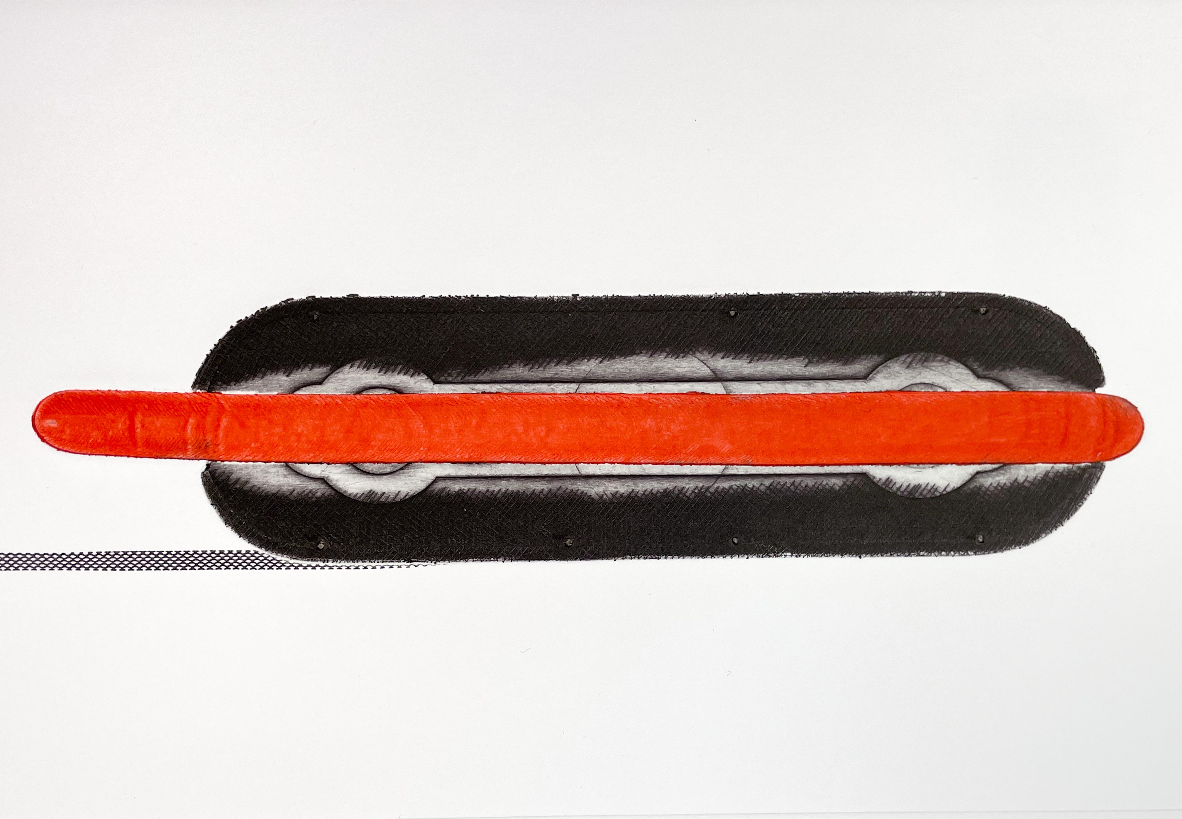
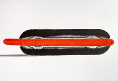
- Hot Dog, Colin Self. British Pop Art cold war americana bright red black etchingBy Colin SelfLocated in New York, NYA contemporary of David Hockney and Peter Blake, Colin Self is an important British printmaker whose innovative etching techniques and novel use of found materials have defined his d...Category
Early 2000s Pop Art Figurative Prints
MaterialsDrypoint
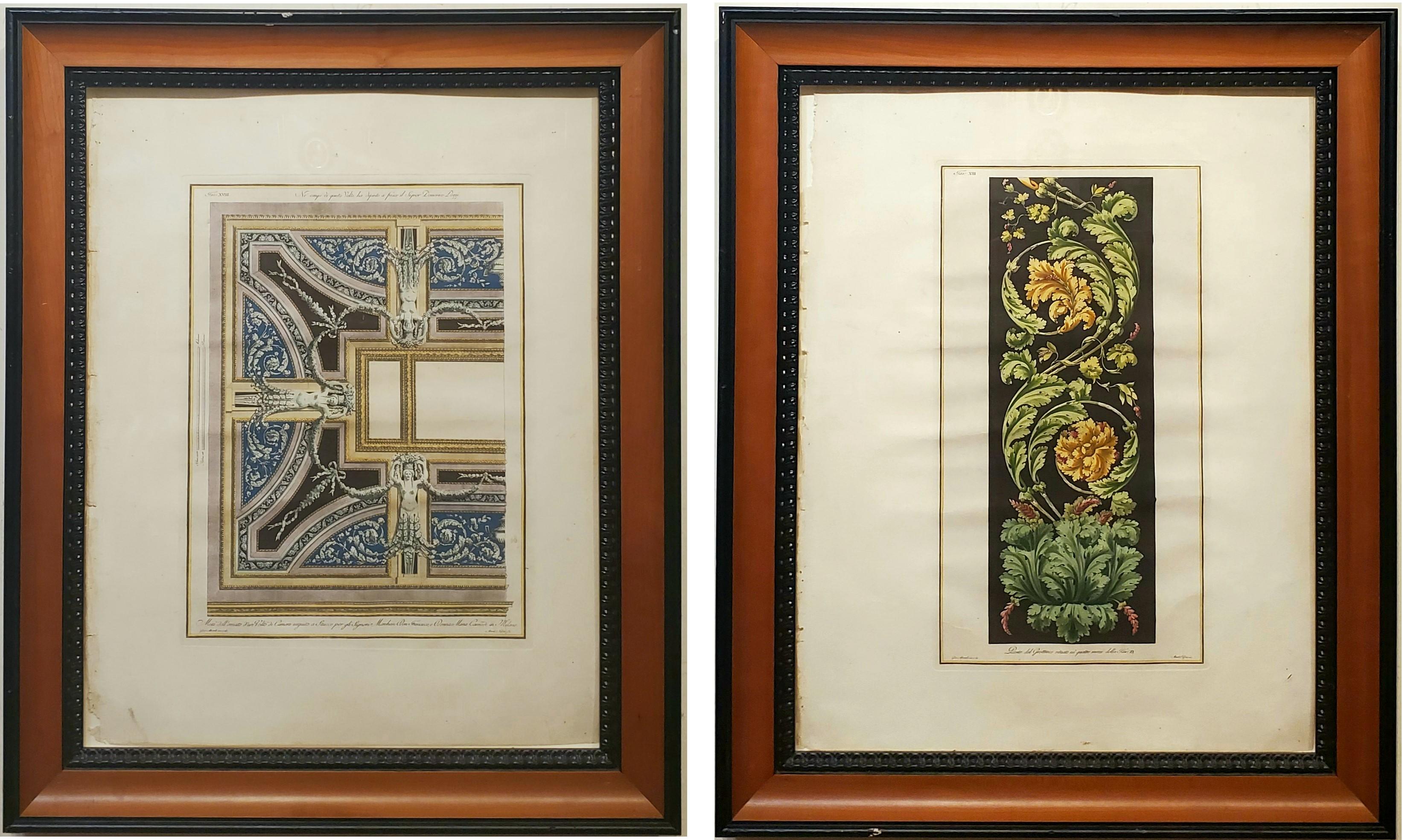
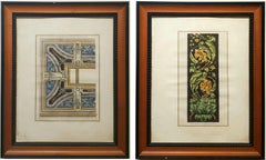
- Framed Pair of Architectural Engravings made After Giocondo AlbertolliLocated in Hallowell, MEFramed Pair of Architectural Engravings made After Giocondo Albertolli in Italy during the Neoclassical period of the 18th Century. This pair of engravings measure 28.5 inches by 23 inches in nice Roma molding picture frames. Priced for the pair. Albertolli is well listed as an engraver in Benezit. page 89, volume 1. Susquehanna Antiques...Category
18th Century Realist Figurative Prints
MaterialsPaper, Engraving
- Trichromatic Flower-piece, Richard Hamilton multi color flower still lifeBy Richard HamiltonLocated in New York, NYAccording to Gesine Tosin, Richard Hamilton irritated contemporary critics in the 1970s with a series of works -- romantic images of flowers, still lifes and landscapes, interspersed with scatological motifs. "Once exhibited, the critics regarded the paintings as evidence either of a kinky sexual aberration or an early onset of senility." (Hamilton 1982, p.79. ) Trichromatic flower-piece is one of these works, which questioned the categories of high and low art through its appropriated imagery. In the words of Richard Hamilton: “The Shit and Flowers series was was inspired in a sense by Barcelona, walking on the Ramblas where thousands of postcards are displayed. (…) I bought three pictures of flowers. I took them back to Cadaqués and began to play about with them, at first by putting a little paint on the surface.” According to Andrew Kim Tyler: “Working at Atelier Crommelynck, Paris in 1973-4, Hamilton used a traditional still life subject, a bouquet of flowers, to pursue his interest in the combination of photographic images with planes of color and hand-drawn aspects, but subverting the image with addition of a large turd. Perversely he set out to produce by manual means an etching with the characteristics of a commercially made reproduction resulting in Trichromatic flower-piece.” In addition to the edition of Trichromatic Flower-piece, Hamilton printed...Category
1970s Expressionist Figurative Prints
MaterialsEngraving, Drypoint, Etching, Aquatint
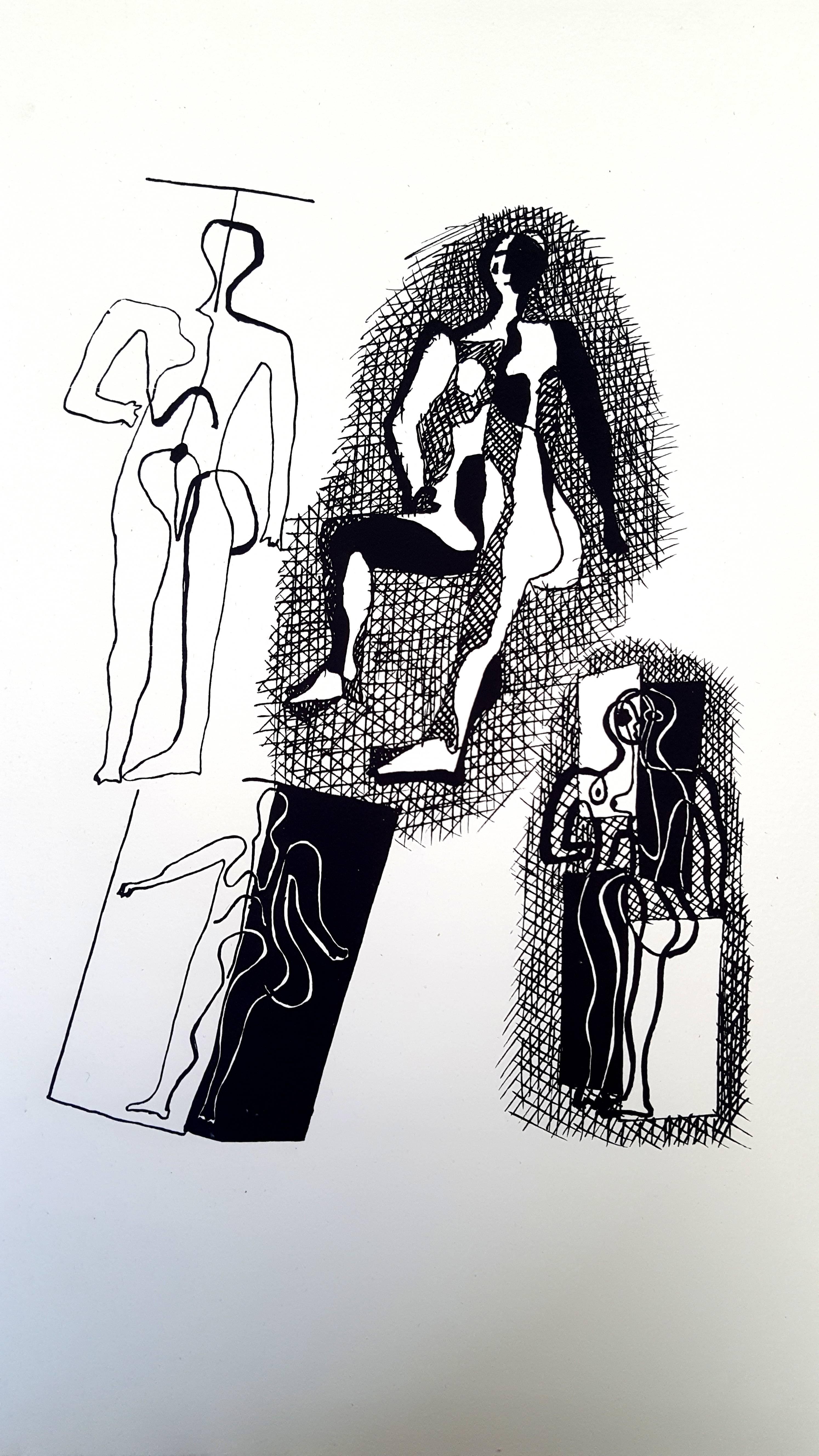
- Pablo Picasso (after) Helene Chez Archimede - Wood EngravingBy (after) Pablo PicassoLocated in Collonge Bellerive, Geneve, CHPablo Picasso (after) Helene Chez Archimede Medium: engraved on wood by Georges Aubert Dimensions: 44 x 33 cm Portfolio: Helen Chez Archimede Year: 1955 Edition: 240 (Here it is on...Category
1950s Modern Figurative Prints
MaterialsWood, Archival Paper, Engraving


Recently Viewed
View AllMore Ways To Browse
Brass Framed Art
Antique Framing Square
Antique Brass Plaques
Brass Antique Plaques Brass Plaques
Brass Plaque Antique
Antique Brass Framed Art
Used Stone Slabs
Lady Dior In Black
Church Stone
Diamond Netherlands
Antique Ornate Gold Frame
Netherlands 16th Century
16th Century Brass
Antique Mauve
Church Angels
Brass Print Frame
Ornate Brass Frame
Lady Dior Gray