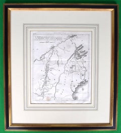
Items Similar to Le Coste Nord Ovest Dell' America E Nord Est Dell' Asia Delineate Sulle Ultime O

Want more images or videos?
Request additional images or videos from the seller
1 of 10
UnknownLe Coste Nord Ovest Dell' America E Nord Est Dell' Asia Delineate Sulle Ultime O1798
1798
$950
£719.05
€827.97
CA$1,351.47
A$1,463.98
CHF 770.85
MX$17,769.70
NOK 9,613.41
SEK 9,089.25
DKK 6,181.06
About the Item
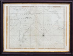
Map Sz: 14 1/2"H x 19 7/8"W
Frame Sz: 21"H x 26 3/8"W
A fine example of Cassini's 1798 map of Alaska, the Bering Strait, and Siberia. Cassini issued this map in his 1798 atlas to illustrate the discoveries made by James Cook. Cook was the first to accurately chart the Alaskan coastline and provide a detailed mapping of the Aleutian Islands. Cook's zigzagging route is shown as he skirts the Aleutian Islands, passes through the Bering Strait into the Arctic Ocean, and then turns back to sail south along the Siberian Coast. Here the Aleutians are collectively identified as Isole Alessiane, though many of the original islands are clearly given indigenous names. A large decorative cartouche in the lower left depicts four American Indians and a baby. This is perhaps the most beautiful of the many maps designed to illustrate Cook's voyages.
Cassini, Giovanni Maria (1745 - 1824) Glovanni Maria Cassini (1745 - 1824) was a Rome based Italian mathematician, globe maker, geographer, engraver, and cartographer active in the later part of the 18th and early 19th century. He was a disciple of Glovanni Battista Piranesi. He Invented new form of projection used for an atlas of the kingdom of Naples issued by Glovanni Antonio Rizzi Zannoni. Cassini is best known as a globe maker and is considered the last of the great 18th century globe makers. His maps are distinctive for their fine engraving, dark strong impressions, and elaborate distinctive cartouche work. Unlike many map and atlas publishers of the perlod, Cassini did all of his own engraving work - this impregnating each map with his unmistakable style. Though he produced a significant corpus ( well-regarded work, little is known of Cassini's personal life. G. M. Cassini is often mistakenly associated with the well-known French cartographic family of the sam name, however, they are not related.
Cook, James (November 7, 1728 - February 14, 1779) Captain James Cook (7 November 1728 - 14 February 1779) is a seminal figure in the history of cartography for which we can offer only a cursory treatment here. Cook began sailing as a teenager in the British Merchant Navy before joining the Royal Navy in 1755. He was posted in America for a time where he worked Samuel Holland, William Bligh, and others in the mapping of the St. Lawrence River and Newfoundland. In 1766 Cook was commissioned to explore the Pacific and given a Captaincy with command of the Endeavour. What followed were three historic voyages of discovery, the highlights of which include the first European contact with eastern Australia, the discovery of the Hawailan Islands (among many other Polynesian groups), the first circumnavigation of New Zealand, some of the first sightings of Antarctica, the first accurate mapping of the Pacific Northwest, and ultimately his own untimely death at the hands of angry Hawaiians in 1779. The influence of Cook work on the mapping and exploration of the Pacific cannot be understated.
- Creation Year:1798
- Dimensions:Height: 21 in (53.34 cm)Width: 26.38 in (67.01 cm)
- Medium:
- Period:1790-1799
- Condition:
- Gallery Location:Bristol, CT
- Reference Number:Seller: 431601stDibs: LU1260113221862
About the Seller
4.8
Vetted Professional Seller
Every seller passes strict standards for authenticity and reliability
Established in 2000
1stDibs seller since 2019
131 sales on 1stDibs
Typical response time: 1 hour
- ShippingRetrieving quote...Shipping from: Bristol, CT
- Return Policy
Authenticity Guarantee
In the unlikely event there’s an issue with an item’s authenticity, contact us within 1 year for a full refund. DetailsMoney-Back Guarantee
If your item is not as described, is damaged in transit, or does not arrive, contact us within 7 days for a full refund. Details24-Hour Cancellation
You have a 24-hour grace period in which to reconsider your purchase, with no questions asked.Vetted Professional Sellers
Our world-class sellers must adhere to strict standards for service and quality, maintaining the integrity of our listings.Price-Match Guarantee
If you find that a seller listed the same item for a lower price elsewhere, we’ll match it.Trusted Global Delivery
Our best-in-class carrier network provides specialized shipping options worldwide, including custom delivery.More From This Seller
View AllProperty From The Collection Of Mrs Marietta Peabody Tree & The Late Ronald Tree
Located in Bristol, CT
w/ 356 lots
Sotheby Parke Bernet New York
October 8-9, 1976
9 1/4" x 8 3/4"
Ronald Tree was a former editor of Forum Magazine who had moved to England in the 1930s and set up residence in the magnificent Ditchley Park Manor. A member of Parliament, Tree was also a friend of Churchill, who visited Ditchley Park often during the Second World War. After the war the Trees packed up the “country house” contents of the manor and moved it to New York, where they lived until the contents were sold at this auction. A wonderful auction of “country manor” furnishings and decorations. Churchill smoked and drank in these chairs...
While involved with Huston and married to FitzGerald, Marietta began an affair with Ronald Tree, who was a grandson of retail magnate Marshall Field and MP for Harborough, Leicestershire.
Tree and Peabody divorced their spouses at the end of World War II and married on July 26, 1947. Marietta moved into Tree's home, Ditchley Park, but found herself bored with English country life. Tree and most of his friends were Conservatives, and Democrat Marietta again found herself politically isolated. Their daughter Penelope was born in 1949.
Short of money, Tree sold Ditchley and agreed to return to New York City with Marietta, her daughter Frances Fitzgerald and their own daughter, future '60s fashion model Penelope Tree...
Category
1970s More Art
Materials
Paper

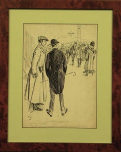
Two To One, Bar None
Located in Bristol, CT
Pen & ink drawing by F.W. (LL) depicting two dapper racecourse gents enquiring, Are they engaged? Yes, but she won't marry him until he gives up the "ring"
Art Sz: 13 3/4"H x 9 3/4"...
Category
20th Century Drawings and Watercolor Paintings
Materials
Ink, Pen
Duche Nassau
Located in Bristol, CT
Stylish equestrian cavalry colour plate w/ hand-gouache highlights depicting two gendarmerie officers en grande tenue
Art Sz: 12"H x 8"W
Frame Sz: 16 3/4"H x 12 1/2"W
w/ coral mat...
Category
19th Century Prints and Multiples
Materials
Gouache
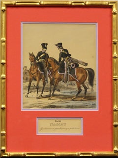
$750
American Revolution Map Drawn For John Marshall's "Life Of Washington" First Acc
Located in Bristol, CT
A Map Of The Country Which Was The Scene Of Operations Of The Northern Army: Including The Wilderness Through Which Gerneral Arnold Marched To Attack Plate VI
Map Sz: 11"H x 9 1/4"W...
Category
Early 1800s Prints and Multiples
Materials
Paper, Engraving
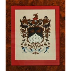
NEC Coat-of-Arms
Located in Bristol, CT
Classic gouache armorial/ coat-of-arms NEC Temere Timide
Art Sz: 13 1/4"H x 10 1/2"W
Frame Sz: 19"H x 16"W
Category
20th Century Paintings
Materials
Gouache
$750
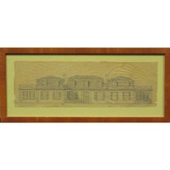
"Design For A French House"
Located in Bristol, CT
Architectural rendering on parchment paper depicting an imposing French style residence
Drawing Sz: 4 1/4"H x 13"W
Frame Sz: 6 3/4"H x 15 1/2"W
Category
20th Century Prints and Multiples
Materials
Paper
You May Also Like
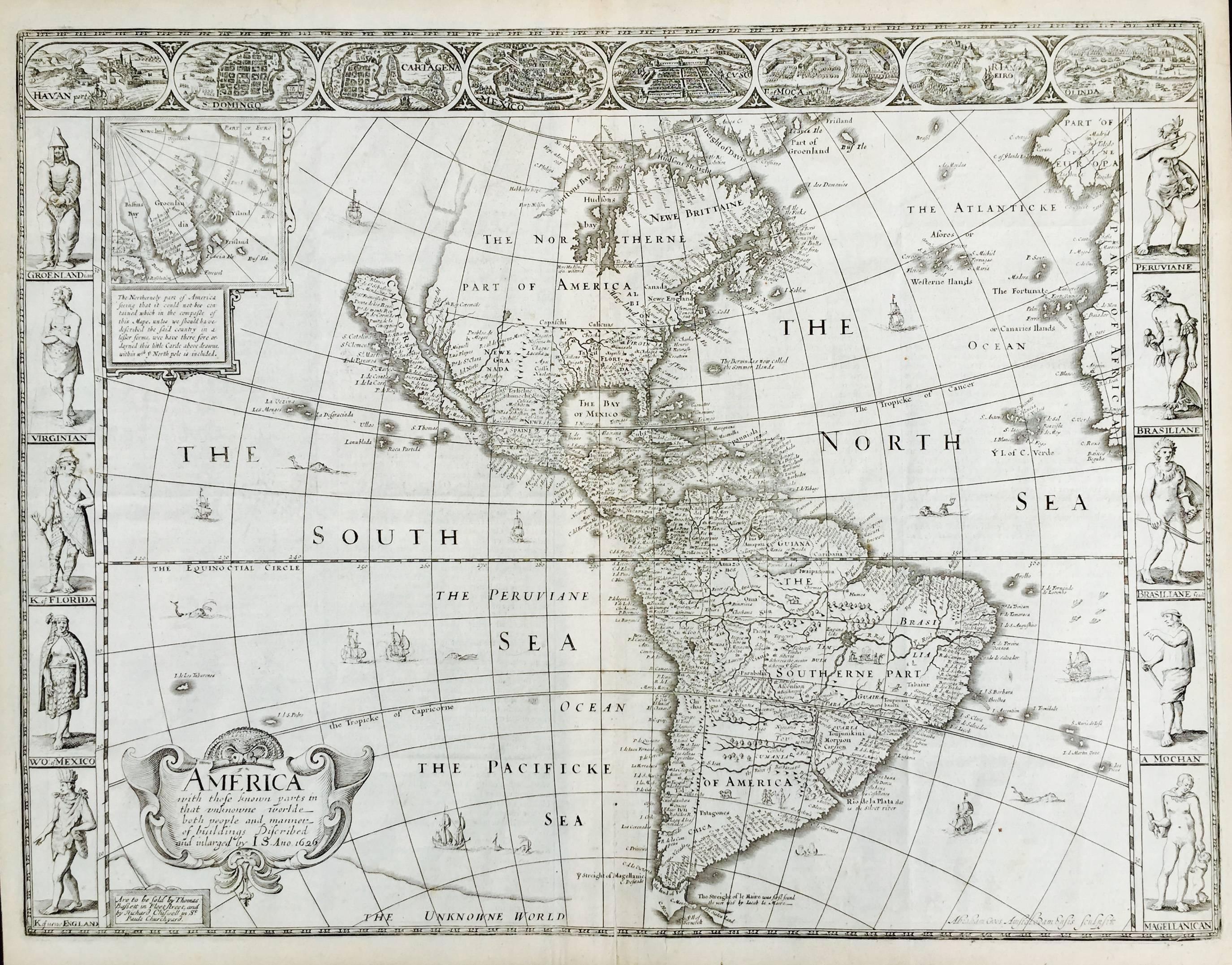
AMERICA
By John Speed
Located in Santa Monica, CA
IMPORTANT AMERICAN MAP - ONE OF THE FIRST TO SHOW CALIFORNIA as an ISLAND
JOHN SPEED (1552-1629)
AMERICA - With Those Known Parts In That Unknown Worlde (sic),
1626-(76)
(Burden 217 iv/iv) Engraving, uncolored. Engraved by Abraham Goos and
published by Thomas Basset and Richard Chiswell - 4th state of 4 in 1676
15 1/8 x 20 1/2” From “A Prospect of the Most Famous Parts of the
World”. Generally good condition. A repaired split in lower centerfold. This
is the most common version of this important map...
Category
1620s Old Masters Landscape Prints
Materials
Engraving

$4,000 Sale Price
52% Off
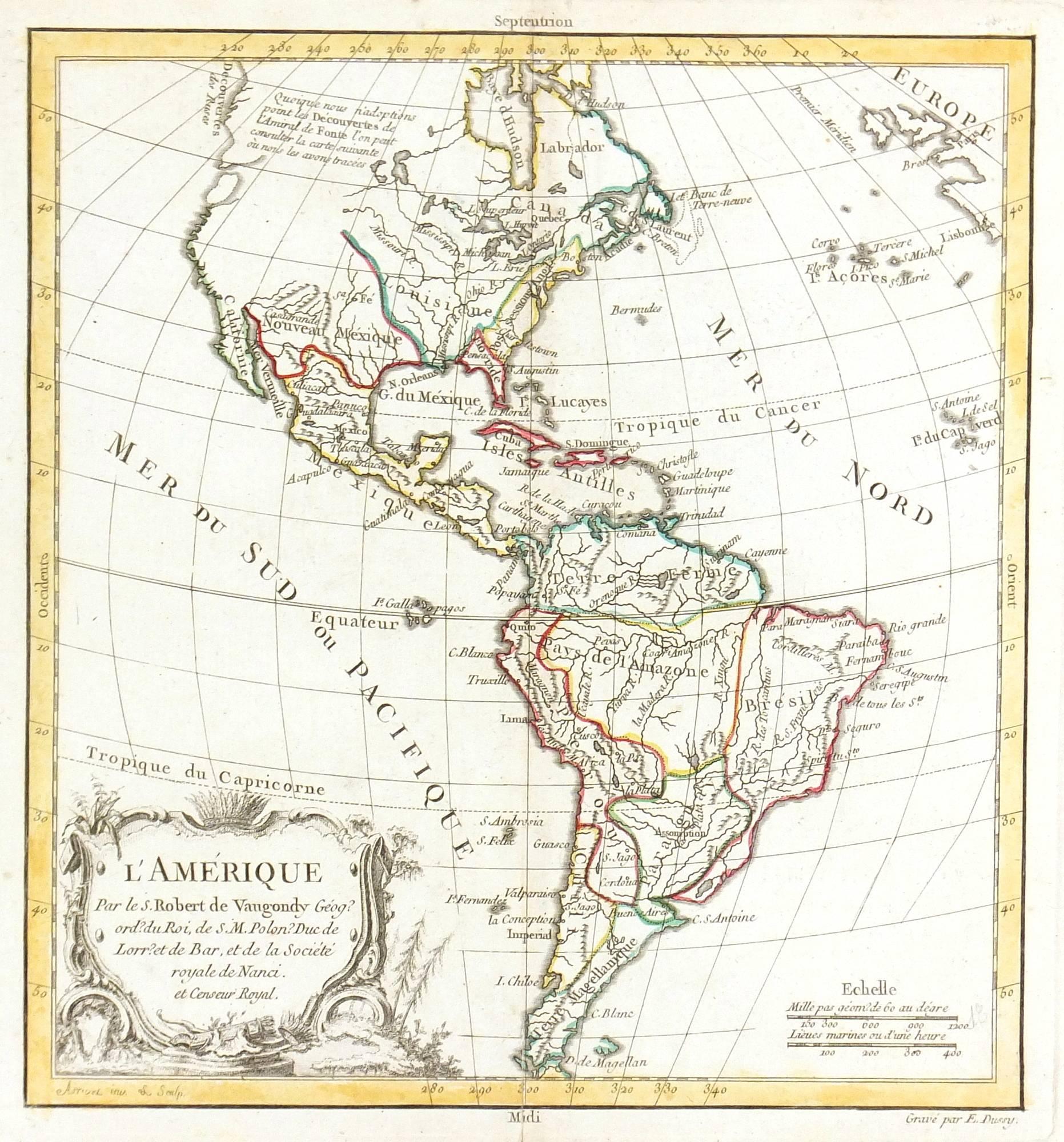
Map of Americas
Located in Houston, TX
Over 200 year old engraved map of Americas by Robert de Vaugondy from 1783. Original hand color. Shows North, Central and South Americas. Note the po...
Category
1780s More Prints
Materials
Ink, Watercolor, Handmade Paper

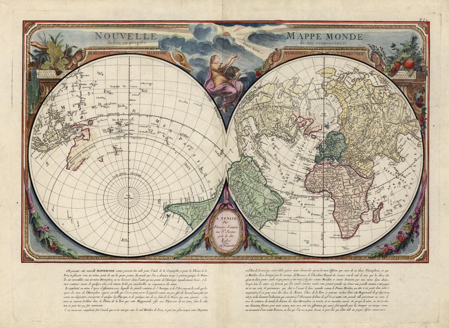
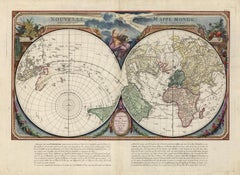
Nouvelle Mappe Monde, dediee au progres de nos connoissances.
Located in New York, NY
A handsome and well-engraved world map constructed with the prime meridian through Paris. The hemispheres are rotated through 45 degrees. This is an unusual projection for a world map and was based on the work of the French Academie Royale des Sciences. This particular impression is by Remondini who re-issued Santini's "Atlas Univ." in 1784. "Nouvelle Mappe Monde" is a copper plate engraving published by Giuseppe Remondini, Venice. The printed image size is just over 15 x 25 inches. Overall the map is in good condition with three small tears at the paper edge - all repaired. Modern (not 18th...
Category
18th Century Other Art Style More Prints
Materials
Watercolor, Engraving
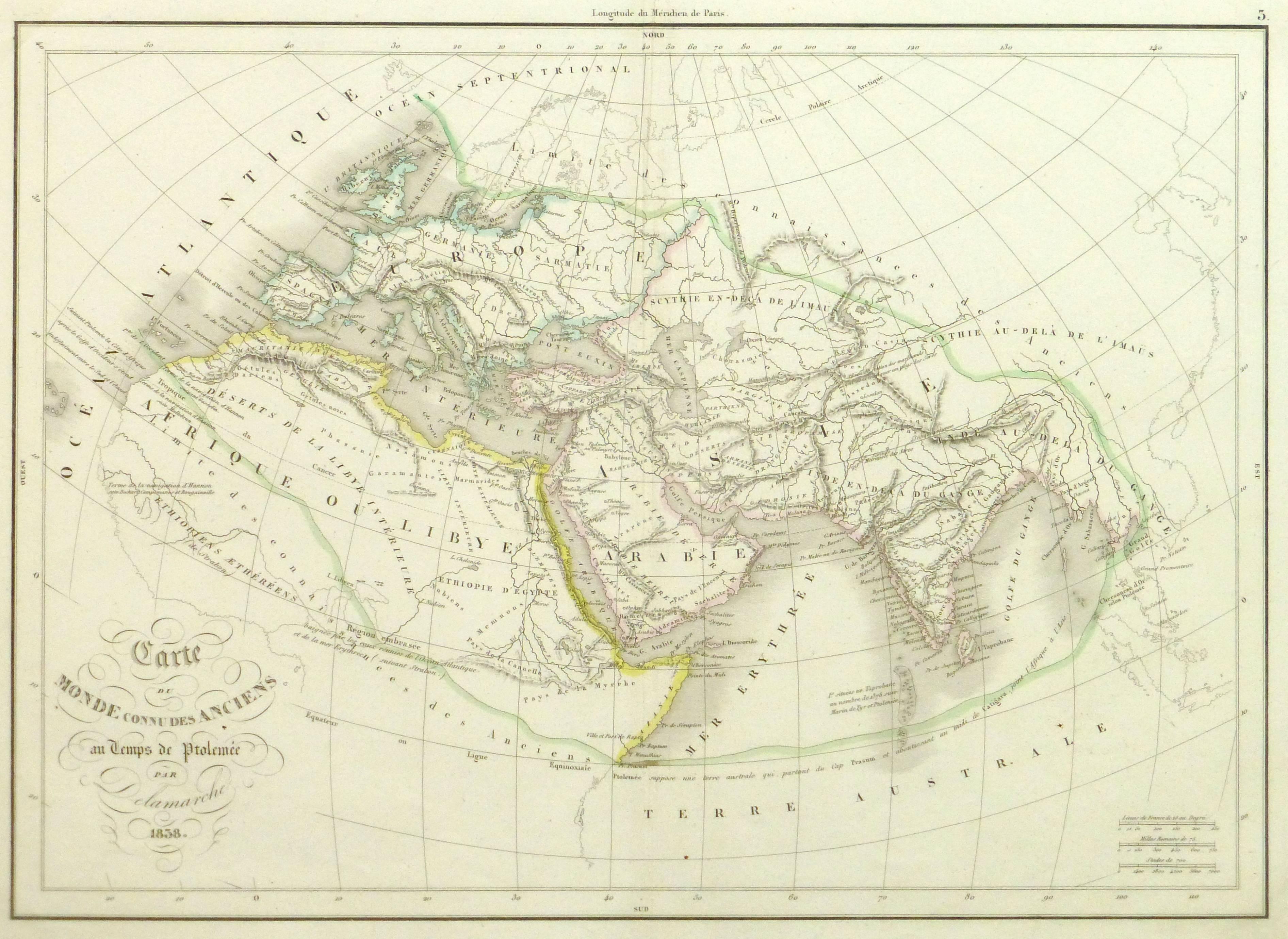
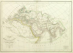
Ancient World Map
Located in Houston, TX
Over 150 year old engraved map of the world as it was known during the antiquities by cartographer Delamarche from 1838. Original hand color. Shows African, European and Asian cont...
Category
1830s More Prints
Materials
Ink, Watercolor, Handmade Paper
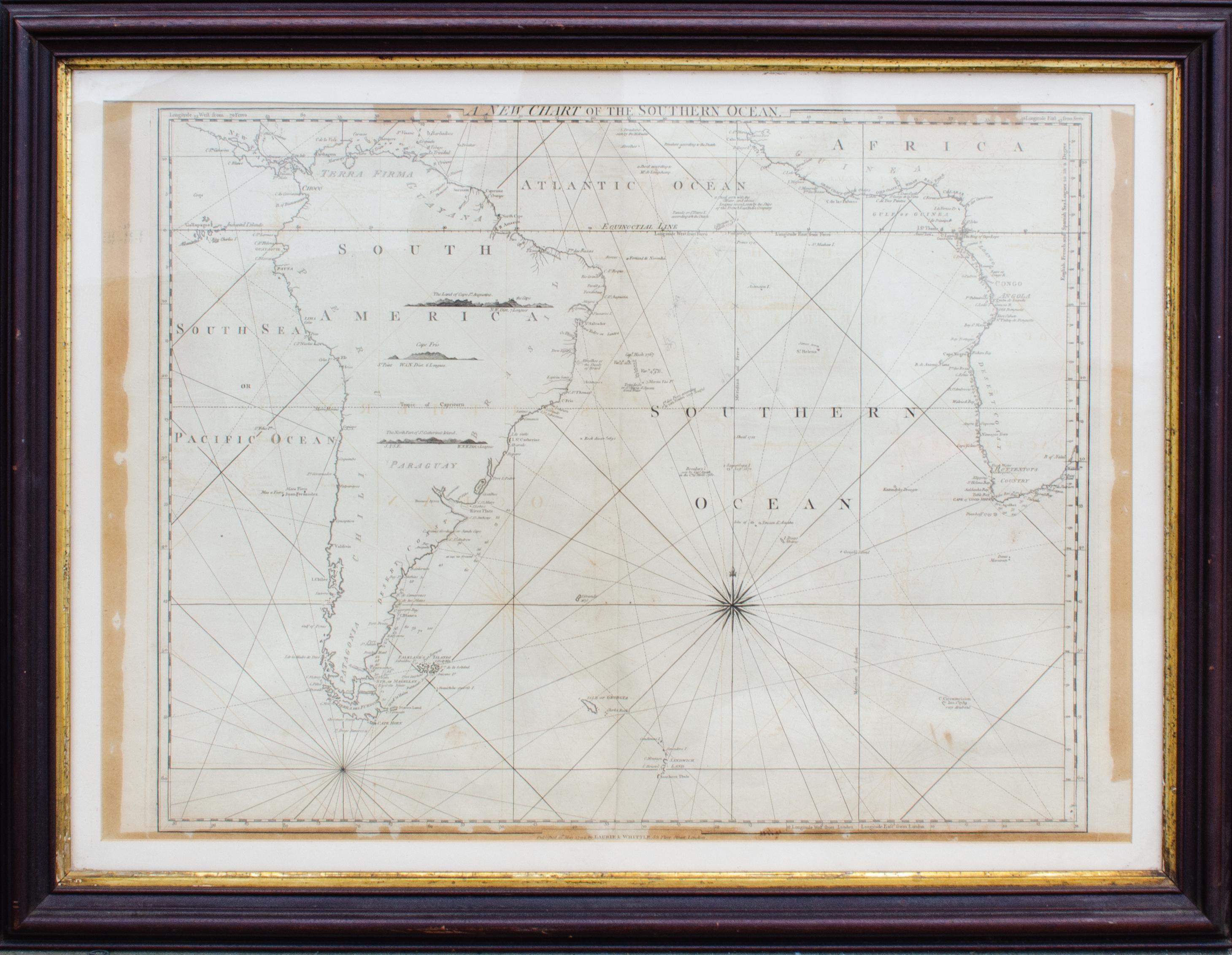
Antique Map of the Southern Oceans, South America and Africa
Located in New York, NY
Antique Map of the South Atlantic, c. 1800s
Engraving
20 x 28 in.
Framed: 25 3/4 x 33 3/4 in.
Category
19th Century Realist Figurative Prints
Materials
Engraving
Drawing, Vault of the Hall of the Eagles Domus Aurea Vincenzo Brenna
Located in Milan, IT
Drawing on paper done in India ink, white lead and gouache; depicting the frescoed vault of the Gallery of the Eagles in the Domus Aurea. The perimeter band is occupied by reserves i...
Category
18th Century Other Art Style Abstract Paintings
Materials
India Ink, Gouache
$17,667 Sale Price
20% Off