Ifpda International Fine Print Dealers Association
International Fine Print Dealers Association (IFPDA)
Launched in 1987, the International Fine Print Dealers Association has continually set the bar for quality and ethics while promoting prints as original works of art to generations of collectors, curators and art lovers. With over 160 members in 13 countries, the IFPDA is a worldwide community of leading dealers and editions publishers who represent the full spectrum of printmaking. Each year, the IFPDA hosts the IFPDA Print Fair in New York, the only major fair dedicated to fine-art prints.
to
1
4
2,648
951
884
783
729
362
335
323
318
299
229
208
207
188
164
162
149
136
133
84
83
78
60
54
39
35
27
26
23
20
17
16
12
11
10
10
9
7
6
5
5
5
5
4
4
3
3
3
3
2
2
1
1
1
1
1
1
1
Period: Early 17th Century
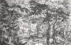
Landscape with Pair on Wooden Bridge
By Nicolaes de Bruyn
Located in Chicago, IL
Engraving after Egidius Coninxloo (c. 1581 - 1619), executed by Nicolaes De Bruyn (Antwerp 1571 - 1652 Amsterdam)
Unidentified watermark
Category
Early 17th Century Old Masters Ifpda International Fine Print Dealers Association
Materials
Engraving
The Bohemians
By Jacques Callot
Located in New York, NY
Jacques Callot (1592-1635), The Bohemians, the set of four etchings touched with burin, 1621. Reference: Lieure 374 (second state of four); Lieure 375-77 (second state of two). In ve...
Category
1620s Old Masters Ifpda International Fine Print Dealers Association
Materials
Etching
AMERICA
By John Speed
Located in Santa Monica, CA
IMPORTANT AMERICAN MAP - ONE OF THE FIRST TO SHOW CALIFORNIA as an ISLAND
JOHN SPEED (1552-1629)
AMERICA - With Those Known Parts In That Unknown Worlde (sic),
1626-(76)
(Burden 217 iv/iv) Engraving, uncolored. Engraved by Abraham Goos and
published by Thomas Basset and Richard Chiswell - 4th state of 4 in 1676
15 1/8 x 20 1/2” From “A Prospect of the Most Famous Parts of the
World”. Generally good condition. A repaired split in lower centerfold. This
is the most common version of this important map...
Category
1620s Old Masters Ifpda International Fine Print Dealers Association
Materials
Engraving
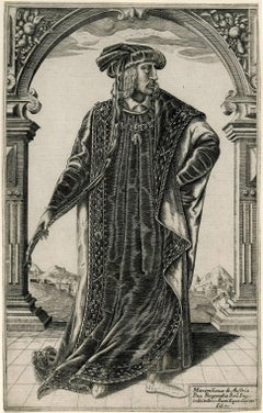
Maximillian I, Holy Roman Emperor
By William Rogers (b.1545)
Located in Fairlawn, OH
Reference: Hind 15 I/II
Category
Early 1600s Ifpda International Fine Print Dealers Association
Materials
Engraving
Related Items
View of Pisaro, Italy: A 16th Century Hand-colored Map by Braun & Hogenberg
By Franz Hogenberg
Located in Alamo, CA
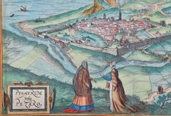
This is a 16th century original hand-colored copperplate engraved map of View of Pezaro (Pisaro), Italy entitled "Pisaurum vulgo Pezaro" by Georg Braun & Franz Hogenberg, from their famous city atlas "Civitates Orbis Terrarum", published in Augsberg, Germany in 1575.
The map depicts a view of Pesaro, Italy from the west looking over the town to the Adriatic Sea. The River Foglia flows into the Adriatic in the foreground. The only identifiable building is the cathedral of San Domenico, which rises above the other roofs with its tall spire. Two women, dressed in styles of the 16th century are in conversation on a hill in the foreground on the left. Pesaro is in the province of Pesaro and Urbino and lies on the Adriatic and east of Florence. The city, which was founded by the Etruscans and named Pisaurum by the Romans, belonged from AD 754 onwards to the Papal States, and after 1285 was controlled by the princely families of Malatesta, Sforza and della Rovere. Today it is the capital of the province of Pesaro and Urbino and has a population of about 92,000. Pesaro's most famous resident, composer Gioacchino Rossini, was born here in 1792.
The following is an English translation of an excerpt from Braun's description of the city: "We believe that the astonishingly short life of the inhabitants of Pesaro comes not only from the insalubrious air, but also from the great quantity of delectable and delicious fruits which they consume to excess. For this causes the production in their bodies of evil humours, which then lead to incurably fatal diseases. The area around the city is most charming and well planted with vineyards, fig trees, olive trees and other fruit-bearing trees."
References: Van der Krogt 4, 3369, state 1; Taschen, Braun and Hogenberg...
Category
16th Century Old Masters Ifpda International Fine Print Dealers Association
Materials
Engraving
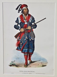
Tuko-See-Mathla, Seminole Chief: Original Hand-colored McKenney & Hall Engraving
By McKenney & Hall
Located in Alamo, CA
This is an original 19th century hand-colored McKenney and Hall engraving of a Native American entitled "Tuko-See-Mathla, A Seminole Chief, No. 106", published by Rice, Rutter & Co. in 1865.
This original McKenney and Hall engraving is presented in a cream colored mat, suitable for framing with a protective clear sleeve. The mat measures 13.88" x 11.75" and the sheet measures 10.63" x 7.38. There is minimal spotting in the periphery, but the print is otherwise in very good condition.
Col. Thomas J. McKenney was Superintendant of The Bureau of Indian Affairs from 1816 until 1830. He was one of a very few government officials to defend American Indian interests and attempt to preserve their culture. He travelled to Indian lands meeting the Native American leaders. He brought with him an accomplished artist, James Otto Lewis...
Category
Mid-19th Century Naturalistic Ifpda International Fine Print Dealers Association
Materials
Engraving
Frankfort, Germany: A 16th Century Hand-colored Map by Braun & Hogenberg
By Franz Hogenberg
Located in Alamo, CA
This is a 16th century original hand-colored copperplate engraved map of Frankfort, Germany entitled "Francenbergum, vel ut alij Francoburgum Hassiae Opp" by Georg Braun & Franz Hogenberg, from their famous city atlas "Civitates Orbis Terrarum", published in Cologne, Germany in 1595.
This is an English translation of an excerpt from the original text in the atlas:
"Frankenberg or, according to others, Francoburgum, a town in Hesse. Charlemagne vested the town of Frankenberg with many freedoms and privileges, which it still enjoys to this day, and on account of its valiant and victorious soldiers awarded a signet, upon which there formerly appeared a golden castle with a tower, together with the letter F and a golden crown.
Frankenberg, seen here from the northeast, lies on a hill above the River Eder. The hillside is covered with fields neatly separated by bushes and fences. Soaring above the town is the massive Liebfrauenkirche, which was modelled on St Elizabeth's church in Marburg. The New Town was founded in 1335 at the foot of the hill (right) and merged with the Old Town as late as 1556. Frankenberg was founded by Conrad of Thuringia in 1233/34 to prevent the archbishops of Mainz from expanding their sphere of influence...
Category
16th Century Old Masters Ifpda International Fine Print Dealers Association
Materials
Engraving
Not-Chi-Mi-Ne, An Ioway Chief: Original Hand-colored McKenney & Hall Engraving
By McKenney & Hall
Located in Alamo, CA
This is an original 19th century hand-colored McKenney and Hall engraving of a Native American entitled "Not-Chi-Mi-Ne, An Ioway Chief, No. 91", published by Rice, Rutter & Co. in 1865.
This original McKenney and Hall engraving is presented in a cream colored mat, suitable for framing with a protective clear sleeve. The mat measures 13.88" x 11.75" and the sheet measures 10.63" x 7.38. There is a spot in the lower left margin and tiny faint spots in the periphery, but the print is otherwise in very good condition.
Col. Thomas J. McKenney was Superintendant of The Bureau of Indian Affairs from 1816 until 1830. He was one of a very few government officials to defend American Indian interests and attempt to preserve their culture. He travelled to Indian lands meeting the Native American leaders. He brought with him an accomplished artist, James Otto Lewis...
Category
Mid-19th Century Naturalistic Ifpda International Fine Print Dealers Association
Materials
Engraving
Map of the World: An Original 18th Century Hand-colored Map by E. Bowen
Located in Alamo, CA
This is an original 18th century hand-colored map entitled "A New & Correct Chart of All The Known World Laid down according to Mercator's Projection" by Emanuel Bowen. It was published in 1744 in London in John Harris's "Navigantium atque Itinerantium Bibliotheca" or "A Complete Collection of Voyages and Travels". This highly detailed and colorful map depicts the world. as it was known in the mid 18th century. A majority of the northern and central portions of Canada and America are left blank due to the purity of knowledge at the time this map was published.
The map is embellished with four Compass Roses in the lower left, lower center, lower right and center, along with many rhumb lines. There a is a decorative title cartouche in the upper left. This colorful, attractive, historical and interesting 1744 map presents the entire world on Mercator's projection as it was understood in the middle part of the 18th century, before the landmark explorations of Captain’s Cook, Vancouver, Wilkes and others. It is an example of a nautical chart, a type of map that was designed specifically for use by mariners. The map is centered on the equator and includes both the Eastern and Western Hemispheres. The continents of North America, South America, Europe, Africa, and Asia are depicted, as well as various islands in the Atlantic, Pacific, and Indian Oceans. The map is laid out according to the Mercator projection, a type of cylindrical map projection that was developed in the 16th century by Flemish cartographer Gerardus Mercator. This projection has the advantage of preserving angles and shapes, making it useful for navigation. The map presents a paucity of inland detail, particularly for the Americas, but major cities, geographical landmarks, and regions are included. Ocean currents and Tradewinds are identified, as well as the magnetic declination lines or magnetic variance, which refers to the difference between true north and compass north. The continents are color coded, enhancing the beauty of this map. The three compass roses indicate the directions of the cardinal points.
The depiction of the western coast of America, the Pacific and Australia are interesting. There was very little exploration of Australia between the navigations of William Damper in 1699 and Tobias Furneaux in 1773. Most of the maps detail relies on the 17th century Dutch expeditions to Australia's western coast, by Abel Tasman and William Janszoon. Van Diemen's Land (Tasmania) and New Guinea appear connected to the Australian continent. New Zealand appears as a single landmass. North of New Zealand there is a landmass labelled 'Ter d' St. Esprit' which probably represents the New Hebrides Islands. This map precedes the accurate exploration of the South Pacific and east coast of Australia by Captain James Cook later in the 18th century. The map includes ‘Drakes' Port,' the site where Sir Francis Drake supposedly landed in 1579 during his 1579 circumnavigation of the globe. Here he claimed territory for England, restocked, and repaired his vessels. Drake named the region New Albion. The exact location of Drake's Port is a cartographic mystery. Drake's Harbor is believed to be in the region of San Francisco Bay, Bodega Bay, San Pablo Bay...
Category
Mid-18th Century Old Masters Ifpda International Fine Print Dealers Association
Materials
Engraving
Fabricius (Ponte Cestio) Bridge : Framed 18th C. Piranesi Architectural Etching
By Giovanni Battista Piranesi
Located in Alamo, CA
This framed 18th century etching by Giovanni Battista Piranesi is entitled "Dimostransi nella Tav. presente la Pianta, ed Elevazione del Ponte, oggi detto Quattro Capi egli è antichissimo, e chiamavasi Fabrizio da L. Fabrizio Presid. delle Strade, che lo fabbrico' nel fine della Repubblica. "(The Plan and Elevation of the Bridge, today called Quattro Capi. The architect is very ancient, and was called Fabrizio da L. Fabrizio Presid. delle Strade, who built it at the end of the Republic). This is plate 18 in volume 4 of Piranesi's "Le antichita romane opera di Giambatista Piranesi architetto veneziano" (Roman antiquities by Giambatista Piranesi Venetian architect). It was published in Rome in 1756-1757.
This etching depicts the plan and elevation of the bridge now called the Ponte dei Quattoro Capi or Ponte Cestio (Bridge of the Four Heads), which in antiquity was called the Bridge of Fabricius after L. Fabricius, the Superintendant of the Streets who built it at the end of the Republic, around 62 BC. It was also been known in the Middle Ages as ‘Ponte Giudeo’ (Bridge of the Jews). The bridge crossed from the left bank or northeast side of the Tiber River to Tiber Island...
Category
1750s Old Masters Ifpda International Fine Print Dealers Association
Materials
Etching
H 25.63 in W 30.5 in D 0.36 in
St. Peter's Square in Basel: 17th Century Engraving by Matthäus Merian
By Matthäus Merian the Elder
Located in Alamo, CA
"Campus Divi Petri qui est Basileae" (St. Peter's Platz in Basel) is a 17th century engraving by the old master engraver Matthäus Merian the Elder...
Category
1650s Old Masters Ifpda International Fine Print Dealers Association
Materials
Engraving
H 15.25 in W 19.94 in D 0.63 in
Piquier Allemand (German Pikeman) /// Old Masters Figurative Man Soldier Antique
Located in Saint Augustine, FL
Artist: Armand Joseph Lallemand (French, 1810-1871)
Title: "Piquier Allemand (German Pikeman)"
Portfolio: Gazette des Beaux-Arts
Year: 1866
Medium: Original Etching on cream laid pap...
Category
1860s Old Masters Ifpda International Fine Print Dealers Association
Materials
Intaglio, Etching, Laid Paper
The New Testament /// Old Masters Biblical Religious Engraving Dutch Angel Art
By Michael Burghers
Located in Saint Augustine, FL
Artist: Michael Burghers (Dutch, c.1647/1648-1727)
Title: "The New Testament"
Portfolio: Holy Bible
*Signed by Burghers in the plate (printed signature) lower left
Year: 1680
Medium: Original Etching and Engraving with recent Hand-Color on watermarked laid paper
Limited edition: Unknown
Printer: John Baskett, London?, UK
Publisher: Moses Pitt, Peter Parker, and Thomas Guy, London?, UK
Sheet size (irregular margins): 17.25" x 10.5"
Image size: 14.75" x 9.5"
Condition: Uneven trimming and light edgewear in margins. One small tear entering image lower right which has been skillfully repaired with added backing paper with archival tape from verso. It is otherwise a strong impression in very good condition with strong colors
Very rare
Notes:
Provenance: private collection - Cotswolds, UK. Comes from the 1685 "Holy Bible" portfolio. John Baskett was deemed printer to the King's most Excellent Majesty, for Great Britain and to the University of Oxford. Large unidentified watermark within center of sheet. There is an example of this work in the permanent collection of the British Museum in London, UK.
In the foreground, John the Evangelist, holding a pen and writing...
Category
1680s Old Masters Ifpda International Fine Print Dealers Association
Materials
Watercolor, Engraving, Etching, Laid Paper, Intaglio
Canterbury: An Original 16th C. Framed Hand-colored Map by Braun & Hogenberg
By Franz Hogenberg
Located in Alamo, CA
This is a framed 16th century map and city view of Canterbury, England entitled "Cantuarbury" by Braun & Hogenburg, from their famous landmark atlas of city views 'Civitates Orbis Terrarum' (Atlas of the Cities of the World), which was first published in Cologne, Germany in 1572. The map of Canterbury was first published in 1588. It depicts a detailed birdseye view of the completely walled and fortified city of Canterbury, with its cathedral the most prominent feature. The coat of arms of England, Canterbury, and the Archbishop of Canterbury are included.
This beautifully hand-colored map is presented in a gold-colored wood frame with a beaded inner trim and a paprika-colored mat that highlights details in the map. The frame measures 18.75" high by 22.25" wide by 0.875" deep. There is a central vertical fold, as issued. The map is in excellent condition.
Braun and Hogenberg's 'The Civitates Orbis Terrarum' was the second atlas of maps ever published and the first atlas of cities and towns of the world. It is one of the most important books published in the 16th century. Most of the maps in the atlas were engraved by Franz Hogenberg and the text, with its descriptions of the history and additional factual information of the cities, was written by a team of writers and edited by Georg Braun. The work contained 546 bird-eye views and map views of cities and towns from all over the world. It gave graphic representation of the main features of the illustrated cities and towns, including the buildings and streets. Although the ordinary buildings are stylized, the principal buildings are reproduced from actual drawings created on location. The principal landmarks and streets can still be recognized today. In addition, the maps often include the heraldic arms of the city, the nature of the surrounding countryside, the important rivers, streams and harbors, even depicting stone bridges, wooden pontoons, flat-bottomed ferries, ships and working boats, wharves and jetties, as well as land-based activities, including horsemen, pedestrians, wagons, coaches, and palanquins. Small vignettes are often included which illustrate the trade, occupations and habits of the local inhabitants, such as agriculture, paper-making and textiles, as well as local forms of punishment, such as gibbets, wheels, floggings etc. Large figures dressed in their local costume are often presented out of proportion in the foreground. The aim of the authors was to give as much information as possible in a pleasing visual form. They succeeded in creating maps that were both informative and decorative works of art. The atlas is a wonderful glimpse of life in medieval Europe.
Georg Braun (1541-1622) was German Catholic...
Category
16th Century Old Masters Ifpda International Fine Print Dealers Association
Materials
Engraving
H 18.75 in W 22.25 in D 0.88 in
View of Emden, Germany: A 16th Century Hand-colored Map by Braun & Hogenberg
By Franz Hogenberg
Located in Alamo, CA
This is a 16th century original hand-colored copperplate engraved map of a bird's-eye View of Embden, Germany entitled " Emuda, vulgo Embden vrbs Frisia orientalis primaria" by Georg Braun & Franz Hogenberg, in volume II of their famous city atlas "Civitates Orbis Terrarum", published in Cologne, Germany in 1575.
This is a beautifully colored and detailed map of Emden, a seaport in northwestern Germany, along the Ems River and perhaps portions of over Dollart Bay, near the border with the Netherland. The map depicts a bird's-eye view of the city from the southwest, as well as a view of the harbor and an extensive system of canals. Numerous ships of various sizes, as well as two rowboats containing numerous occupants are seen in the main waterway in the foreground and additional boats line two canals in the center of the city. Two men and two women are shown on a hill in the foreground on the right, dressed in the 16th century style of nobility. Two ornate crests are included in each corner. A title strap-work cartouche is in the upper center with the title in Latin. The crest on the right including Engelke up de Muer (The Little Angel on the Wall) was granted by Emperor Maximilian I in 1495.
This is an English translation of an excerpt of Braun's description of Embden: "In Emden, the capital of East Frisia, rich merchants live in very fine houses. The city has a broad and well-situated harbour, which in my opinion is unique in Holland. Frisia and the whole of the Netherlands, for the ships can anchor here right under the city walls. They have also extended the harbour as far as the New Town, so that up to 400 ships can now find shelter here when the sea is rough."
The emphasis on the harbor and waterways within the city highlights the importance of Emden's place as a seaport at this time. Embden developed from a Dutch/Flemish trading settlement in the 7th-8th centuries into a city as late as late 14th century. In 1494 it was granted staple rights, and in 1536 the harbour was extended. In the mid-16th century Emden's port was thought to have the most ships in Europe. Its population then was about 5,000, rising to 15,000 by the end of the 16th century. The Ems River flowed directly under the city walls, but its course was changed in the 17th century by the construction of a canal. Emden has canals within its city limits, a typical feature of Dutch towns, which also enabled the extension of the harbor. In 1744 Emden was annexed by Prussia and is now part of Germany. It was captured by French forces in 1757 during the Seven Years' War, but recaptured by Anglo-German forces in 1758. During the Napoleonic French era, Emden and the surrounding lands of East Frisia were part of the short-lived Kingdom of Holland.
References:Van der Krogt 4, 1230, State 2; Taschen, Braun and Hogenberg...
Category
16th Century Old Masters Ifpda International Fine Print Dealers Association
Materials
Engraving
Wa-Na-Ta, Chief of the Sioux: An Original Hand-colored McKenney & Hall Engraving
By McKenney & Hall
Located in Alamo, CA
This is an original 19th century hand-colored McKenney and Hall engraving of a Native American entitled "Wa-Na-Ta, Grand Chief of the Sioux, No. 74",...
Category
Mid-19th Century Naturalistic Ifpda International Fine Print Dealers Association
Materials
Engraving
