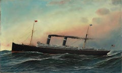
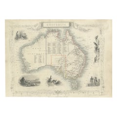
The American Steam-Sailer St. Louis
Located in Jacksonville, FL
owned by International Navigation Company (INC) and was sponsored by First Lady, Frances Clara (née
Category
19th Century Antique Navigation
Materials
Oil
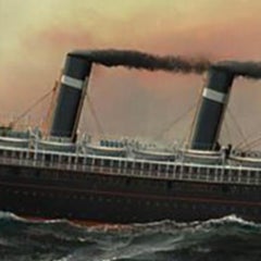
The American Steam-Sailer St. Louis
Located in Jacksonville, FL
owned by International Navigation Company (INC) and was sponsored by First Lady, Frances Clara (née
Oil
$341Sale Price|20% Off
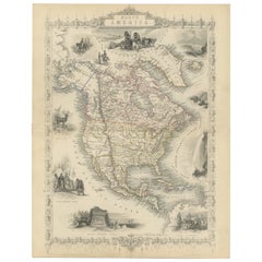
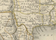
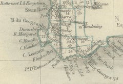
Victorian Visions of the New World: A Detailed Tallis Map of North America, 1851
Located in Langweer, NL
-century maps that were not only tools for navigation but also for education and display, reflecting the
Paper
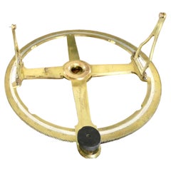
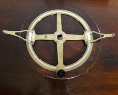
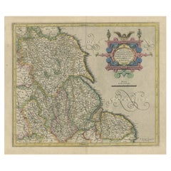
Fine Circular Protractor by William Cary, London c.1810
By Cary
Located in Norwich, GB
including mechanical calculators, measuring instruments, telescopes, microscopes and navigation and
Brass
$350Sale Price|20% Off
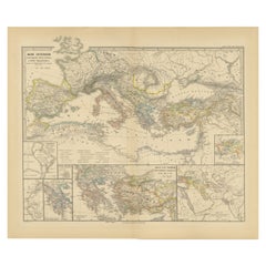
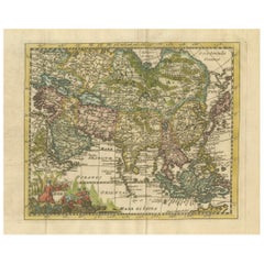
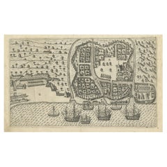
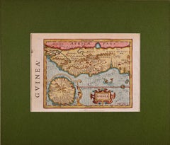
Mediterranean Encounters: From the Punic Wars to the Hannibalic War, 1880
Located in Langweer, NL
within the Empire. 8. **Navigation Lines**: Lines across the sea could represent major trade routes or
Paper
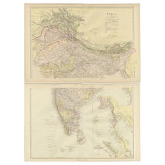
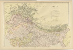
Cartographic Elegance: The British Raj's India, 1882 Atlas by Blackie and Son
Located in Langweer, NL
their navigational utility. The legends and notations, written in English, provide information about the
Paper
$265Sale Price|20% Off
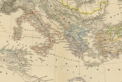
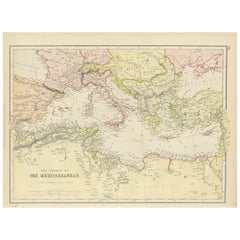
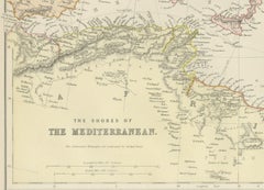
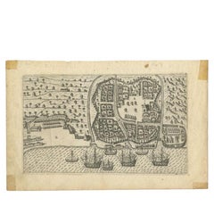
19th Century Antique Map of Mediterranean Shores by Blackie & Son
Located in Langweer, NL
throughout history. Routes and passages are marked, suggesting the lines of maritime navigation that have
Paper
$1,564Sale Price|20% Off
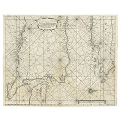
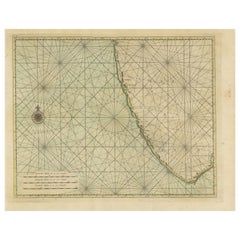
Rare Old English Sea Chart of Part of Indonesia with Java, Madura and Bali, 1711
Located in Langweer, NL
, Seller published an uncompleted book on 'Oriental navigation' in 1675. Unable to continue this Herculean
Paper
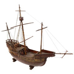
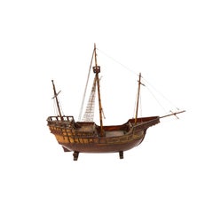
Late 19th century Antique Maritime Model of Cargo-Carrack Probably from Genoa
Located in Milan, IT
round. The carracks were the first ships in Europe used in ocean navigation, large enough to tackle the
Wood
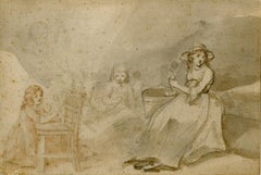
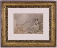
Family Group
By George Morland
Located in Fairlawn, OH
of children's sports, like 'Children Birdnesting,' 'Juvenile Navigation,' 'The Kite entangled
Ink
$341Sale Price|20% Off
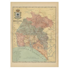
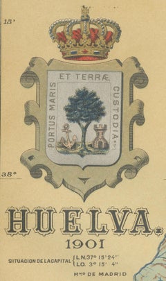
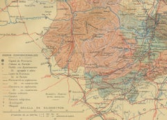
Huelva 1901: A Cartographic Presentation of Andalusia's Atlantic Frontier
Located in Langweer, NL
navigation; from its port, Christopher Columbus set sail on his first voyage to the New World.
Paper
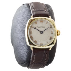
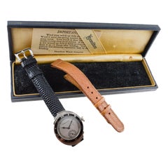
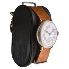
Waltham Yellow Gold Filled Art Deco Watch with Original Dial from 1926
By Waltham
Located in Long Beach, CA
designed timers, navigational devices, automobiles, aviation and nautical equipment. The Waltham Watch
Gold-filled

$12,447Sale Price|30% Off
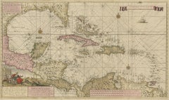
Engraving of a Map of Florida, the Gulf Coast, Caribbean & Central America, 1728
Located in Langweer, NL
as a navigational tool but also as a work of art, reflecting the skill and dedication of its creator
Paper
$626Sale Price|20% Off
Cartographic Elegance of the Mughal Dominion in a Hand-Colored Antique Map, 1705
Located in Langweer, NL
cartographic community. These maps would have been used for navigation, trade, and also to assert political
Paper
$1,111Sale Price|24% Off
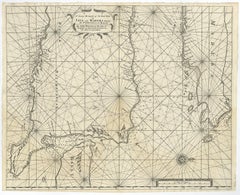
Detailed Map of the Madura Strait, between Java & Madura Island, Indonesia, 1825
Located in Langweer, NL
Fort d'Orange. This map originates from 'Journal de la navigation autour du globe de la frégate "la
Paper
Large Chart of the Gambier Islands, Tuamotu Archipelago, French Polynesia, 1838
Located in Langweer, NL
Aukena, set within a broad lagoon encircled by coral reefs. The chart is rich in navigational detail
Paper

$521Sale Price|20% Off
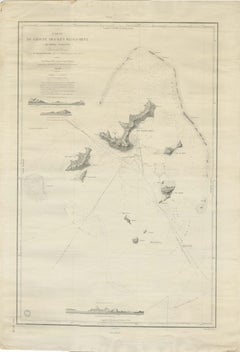
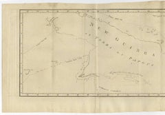
Antique Map of New Guinea and New Britain by P. Carteret, circa 1773
Located in Langweer, NL
discovery in 18th-century Pacific navigation. Dampier’s tracks through the Bismarck Archipelago further
Paper
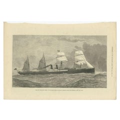

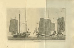
Antique Print of the New Steamship 'Orient', 1879
Located in Langweer, NL
Antique print titled 'The New Steam-Ship Orient, of the Orient Steam Navigation Company's Line, For
Paper

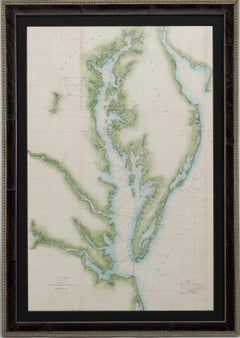
1856 U.S. Coast Survey Map of Chesapeake Bay and Delaware Bay
Located in Colorado Springs, CO
response to a need for accurate navigational charts of the new nation's coasts and harbors. Today, the
Paper
$606Sale Price|20% Off
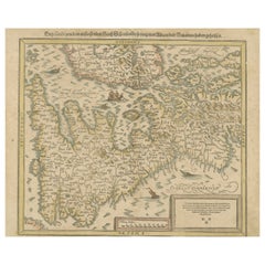
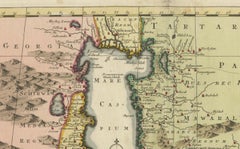
Sebastian Münster's 16th Century Map of the British Isles, ca.1590
Located in Langweer, NL
compass rose can be seen, aiding in navigation. 4. **Regions and Cities**: - Various regions and
Paper
$180Sale Price|20% Off
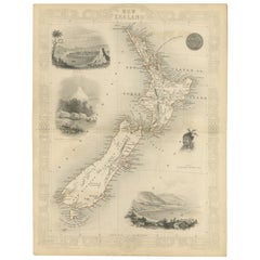
Map of New Zealand Showing Maori Culture and Early Colonial Settlements, 1851
Located in Langweer, NL
practical navigation but also to educate and enthrall the British public with the exotic appeal of their
Paper
$275Sale Price|20% Off
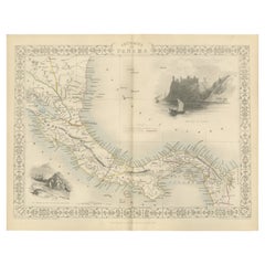
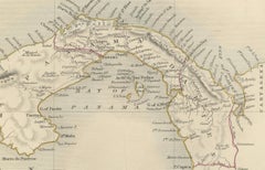
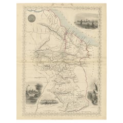
Crossroads of Empires: A John Tallis Map of the Isthmus of Panama, 1851
Located in Langweer, NL
, the area would be vital for global trade and navigation, hence its detailed cartography by the British
Paper
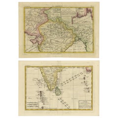
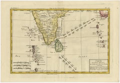
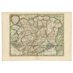
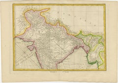
18th Century Cartographic Depiction of Upper India and Ceylon, 1835
Located in Langweer, NL
cartography. Such maps from Bonne's atlas would have been used for educational purposes, navigation, and by
Paper
$369Sale Price|20% Off
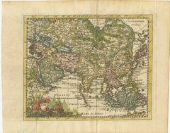
Cartographic Elegance: The Art and Science of 17th-Century Asian Maps, ca.1681
Located in Langweer, NL
period was characterized by significant advancements in navigational techniques and a growing European
Paper

A Voyage Round the World, In the Years MDCCXL, I, II, III, IV, By George Anson
Located in Middletown, NY
navigation charts, mutinies, but also with the successful capture of a Spanish galleon off the coast of the
Gold Leaf
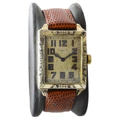
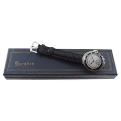
Hamilton White Gold Filled Art Deco Watch With "A.N to H.B" Engraved circa 1920s
By Hamilton
Located in Long Beach, CA
, with contracts for the Navy, they produced the world’s most accurate navigational chronometers. The
Gold-filled
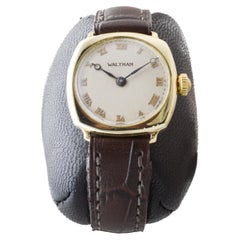
Waltham 14Kt Multi Colored 16 Size Hunters Case Pocket Watch from 1907
By Waltham Watch Company
Located in Long Beach, CA
and the Korean war they designed timers, navigational devices, automobiles, aviation and nautical
Gold
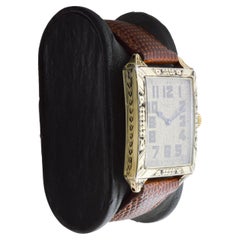
Waltham 14Kt Solid Gold Art Deco Cushion Shape Watch from 1911 Applied Numerals
By Waltham Watch Company
Located in Long Beach, CA
designed timers, navigational devices, automobiles, aviation and nautical equipment. The Waltham Watch
14k Gold
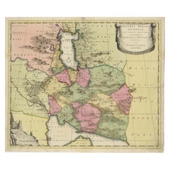
Imperii Persici Delineatio: A 1722 Cartographic Masterpiece of Persia by Schenk
Located in Langweer, NL
-European territories. - **Educational Value:** Maps like these were not only tools for navigation and
Paper

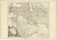
Detailed Original Antique Map of the Turkish Empire with Arabia, 1778
Located in Langweer, NL
monitoring the information published in geography texts, navigational tracts, and travel accounts.
Paper
$312Sale Price|20% Off
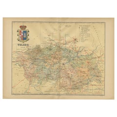
Toledo 1902: A Historical Cartographic Study of this Spanish Province
Located in Langweer, NL
roads, suggests the map's practical use for navigation and travel at the time of its creation. The
Paper
$265Sale Price|20% Off
Antique Print of the Malabar Coast of India showing the VOC establishments, 1726
Located in Langweer, NL
compass rose in the western expanse and scale bars for navigational guidance in the lower left. No text on
Paper
Gold Rush Era Masterpiece: The Tallis & Rapkin Rare Map of Pre-Queensland, 1851
Located in Langweer, NL
by J. B. Allen add a layer of craftsmanship to the map, making it not just a navigational tool but
Paper
$180Sale Price / item|20% Off
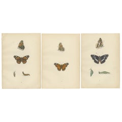
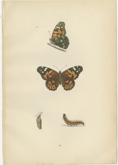
Wings of Elegance: A Victorian Exploration of British Butterfly Splendour, 1890
Located in Langweer, NL
across continents, showcasing an extraordinary feat of endurance and navigation for an insect. This
Paper
$265Sale Price|20% Off
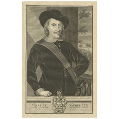
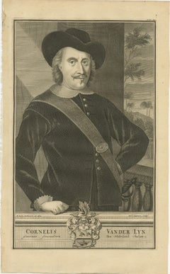
Governor-General Vander Lyn of the Dutch East Indies, Patron of Exploration 1724
Located in Langweer, NL
van der Lijn suggests his active role in the expansion of Dutch navigational knowledge and colonial
Paper
$360Sale Price|20% Off
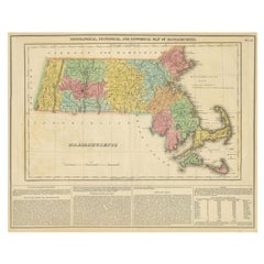
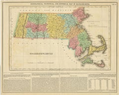
Antique Geographical, Historical and Statistical Map of Massachusetts, 1822
Located in Langweer, NL
. Several navigational hazards are also identified in the Atlantic. The bottom third of the sheet contains
Paper
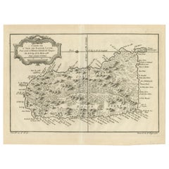
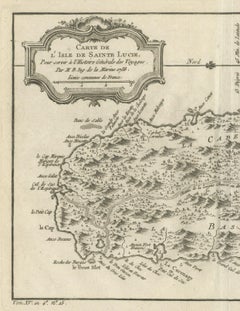
Original Engraved Map of Saint Lucia in the West Indies by Bellin, 1758
Located in Langweer, NL
of Saint Lucia, such as towns, topographical features, coastal landmarks, and even navigational
Paper
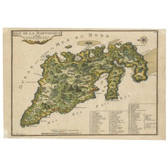

L'isle De La Martinique Caribbean Copper Engraving Original Handcoloring, 1704
Located in Langweer, NL
navigation. 2. **Geographical Features:** It meticulously outlines the island's landscape, including rivers
Paper
$464Sale Price / set|20% Off
Charting the Course of Empire: Bonne's 1770 Masterpiece Maps of the Indian Ocean
Located in Langweer, NL
navigation. The Atlas Moderne was a comprehensive collection of maps covering various parts of the world and
Paper

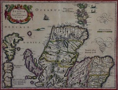
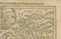
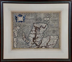
Northern Scotland: 17th Century Hand-colored Map by Mercator
By Gerard Mercator
Located in Alamo, CA
navigation. It is still referred to as The Mercator projection.
Engraving
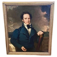
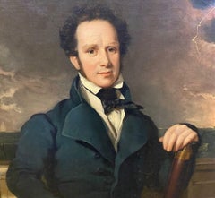
Early 19th Century Portrait of Naval Captain William Compton Bolton
Located in Nantucket, MA
navigational chart, leaning against the taffrail on the quarterdeck of his ship; there are other ships seen on
Canvas
$360Sale Price|20% Off
Antique Print of Bantam, Java, Indonesia by De Bry, c.1610
Located in Langweer, NL
from 'Indiae Orientalis Navigationes (..)' by J. Th. de Bry. Artists and Engravers: Johann Theodor
Paper
Hamilton 14Kt White Gold "Spur" Watch circa 1920's
By Hamilton
Located in Long Beach, CA
again. In addition, with contracts for the Navy, they produced the world’s most accurate navigational
White Gold
A Tallis Map of British Guiana with Colonial Vignettes and Other Landmarks, 1851
Located in Langweer, NL
were not only useful for navigation but also served an educational purpose and were often used to
Paper
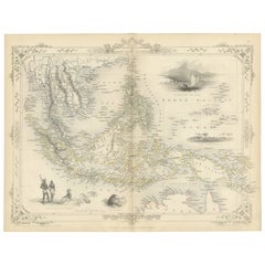
Antique Map of the Malay Archipelago with Images of Indigenous People, 1851
Located in Langweer, NL
of the British public. Tallis's maps are more than just navigational aids; they are visual
Paper

$493Sale Price|20% Off
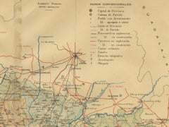
Topographical and Infrastructure Map of the Province of Valencia, 1901
Located in Langweer, NL
usefulness for navigation and understanding the region's geography during the early 20th century. The map
Paper

West Africa: A 17th Century Hand-Colored Map by Mercator/Hondius
By Gerard Mercator
Located in Alamo, CA
longitude calculation and navigational routes to be drawn using straight lines. This was an important
Engraving
Monumental Design with World Map Pillar – Engraving after Volckamer, c.1780
Located in Langweer, NL
symbolic intention as a monument to learning, navigation, or global awareness. This print is a compelling
Paper

Decorative Early Hand-Colored Map of the Northeast of England, ca.1620
Located in Langweer, NL
poles. This allowed for accurate latitude and longitude calculation and also allowed navigational routes
Paper
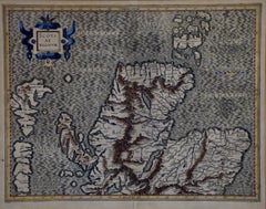
Northern Scotland: 16th Century Hand-colored Map by Mercator
By Gerard Mercator
Located in Alamo, CA
north up and south down, first described in 1569, became the standard map projection for navigation. It
Engraving
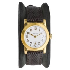
Waltham Nickel Campaign Watch
By Waltham Watch Company
Located in Long Beach, CA
the Korean war they designed timers, navigational devices, automobiles, aviation and nautical
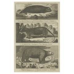
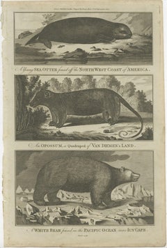
Antique Print of a Sea Otter, an Opossum, and a White Bear, c.1784
Located in Langweer, NL
for making discoveries in geography, navigation, astronomy in the southern and northern hemispheres
Paper
Antique Chart of Dundee, Aberdeen and Montrose in Scotland, C.1774
By Captain Greenvile Collins
Located in Langweer, NL
decorative title cartouche, numerous navigational rhumb lines and soundings. Artists and Engravers
Paper

$322Sale Price|35% Off
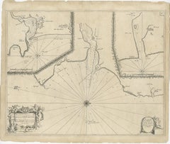
Islands of Diversity: Portugal's Atlantic Archipelagos in 1903
Located in Langweer, NL
maritime details are also provided, suggesting their importance in navigation and trade during that time
Paper
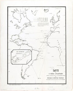
Carte de l'Ocean Atlantique - by F. A. de Varnhagen - 1865
Located in Roma, IT
moins authentiques), sa vie et ses navigations, avec une carte indiquant les routes, by Francisco Adolfo
Etching
$2,133Sale Price|20% Off
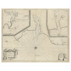
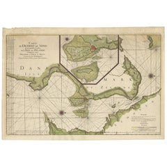
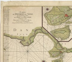
Antique Map: Carte du Détroit du Sond with Copenhagen Inset, 1693
Located in Langweer, NL
chart’s practical and aesthetic appeal. The map is enriched by finely engraved cartouches and navigational
Paper
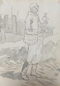
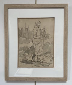
Paul Gavarni (1804-1866) The Puppeteer, "Janvier", original signed drawing
By Paul Gavarni
Located in Paris, FR
eagerly interested in the question of aerial navigation. It is said that he made experiments on a large
Ink
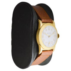
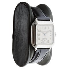
Waltham Gold Filled Art Deco Watch circa 1925 with Original Dial and Strap
By Waltham Watch Company
Located in Long Beach, CA
. Through WW 1, WW 2 and the Korean war they designed timers, navigational devices, automobiles, aviation
Gold-filled