Items Similar to Decorative Early Hand-Colored Map of the Northeast of England, ca.1620


Want more images or videos?
Request additional images or videos from the seller
1 of 5
Decorative Early Hand-Colored Map of the Northeast of England, ca.1620
About the Item
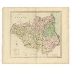
Antique map titled 'Eboracum, Lincolnia, Derbia, Staffordia, Notinghamia, Lecestria, Rutlandia et Norfolcia'.
Decorative early map of the northeast of England, comprising the counties of Yorkshire, Lincolnshire, Derbyshire, Staffordshire, Nottinghamshire, Leicestershire, Rutland and Norfolk. Originates from 'Atlas Sive Cosmographia' by G. Mercator.
Artists and Engravers: Gerard Mercator is one of the most famous cartographers of all time. Mercator was born in Flanders and educated at the Catholic University in Leuven. After his graduation in 1532, Mercator worked with Gemma Frisius, a prominent mathematician, and Gaspar a Myrica, a goldsmith and engraver. Together, these men produced globes and scientific instruments, allowing Mercator to hone his skills. Mercator’s most important contribution was the creation and popularization of a projection which now bears his name. On Mercator projection maps, all parallels and meridians are drawn at right angles to each other, with the distance between the parallels extending towards the poles. This allowed for accurate latitude and longitude calculation and also allowed navigational routes to be drawn using straight lines, a huge advantage for sailors as this allowed them to plot courses without constant recourse to adjusting compass readings.
Condition: Good, original/contemporary hand coloring. Age-related toning, minor wear and soiling. French text on verso, please study image carefully.
- Dimensions:Height: 18.9 in (48 cm)Width: 22.25 in (56.5 cm)Depth: 0 in (0.02 mm)
- Materials and Techniques:
- Period:1620-1629
- Date of Manufacture:circa 1620
- Condition:Wear consistent with age and use.
- Seller Location:Langweer, NL
- Reference Number:
About the Seller
5.0
Platinum Seller
These expertly vetted sellers are 1stDibs' most experienced sellers and are rated highest by our customers.
Established in 2009
1stDibs seller since 2017
1,933 sales on 1stDibs
Typical response time: <1 hour
- ShippingRetrieving quote...Ships From: Langweer, Netherlands
- Return PolicyA return for this item may be initiated within 14 days of delivery.
More From This SellerView All
- Antique Map of the Northeast of England by Mercator 'circa 1620'Located in Langweer, NLAntique map titled 'Eboracum Lincolnia, Derbia, Staffordia, Notinghamia, Lecestria, Rutlandia, et Norfolcia'. Decorative early map of the northeast of England, comprising the countie...Category
Antique Early 17th Century Maps
MaterialsPaper
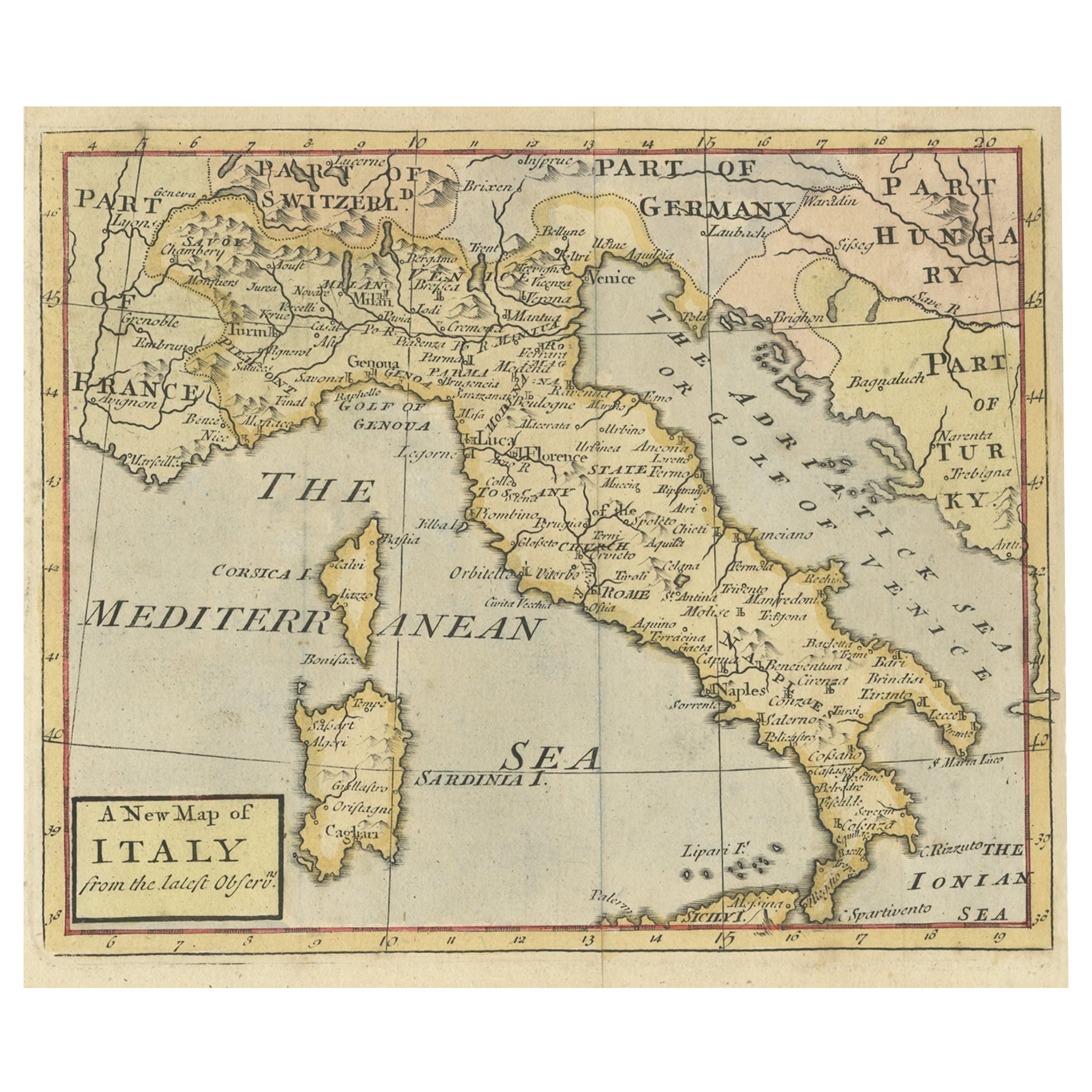
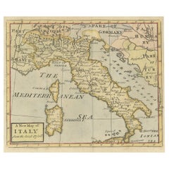
- Nice Decorative Hand-Colored Antique Map of Italy, ca.1745Located in Langweer, NLAntique map Italy titled 'A New Map of Italy from the lastest observations'. Antique map of Italy originating from 'Geography Anatomiz'd: or, The G...Category
Antique 1740s Maps
MaterialsPaper
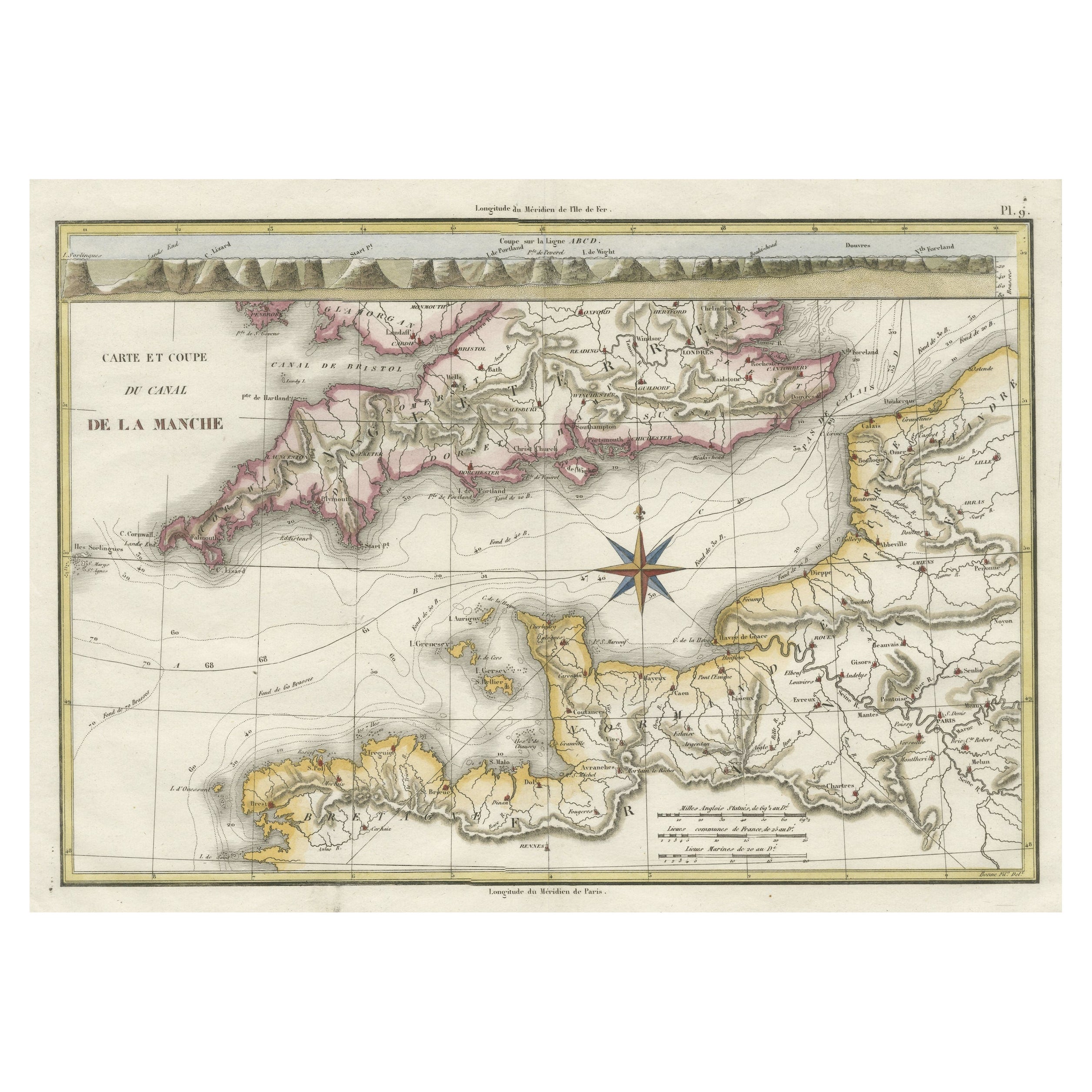
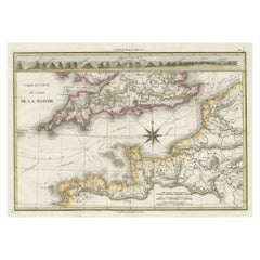
- Decorative Hand-Colored French Map of the English Channel, 1827Located in Langweer, NLAntique map titled 'Carte et Coupe du Canal de la Manche'. Original antique map of the English Channel. Relief shown by hachures; depths by isolines. Profile...Category
Antique Mid-19th Century Maps
MaterialsPaper
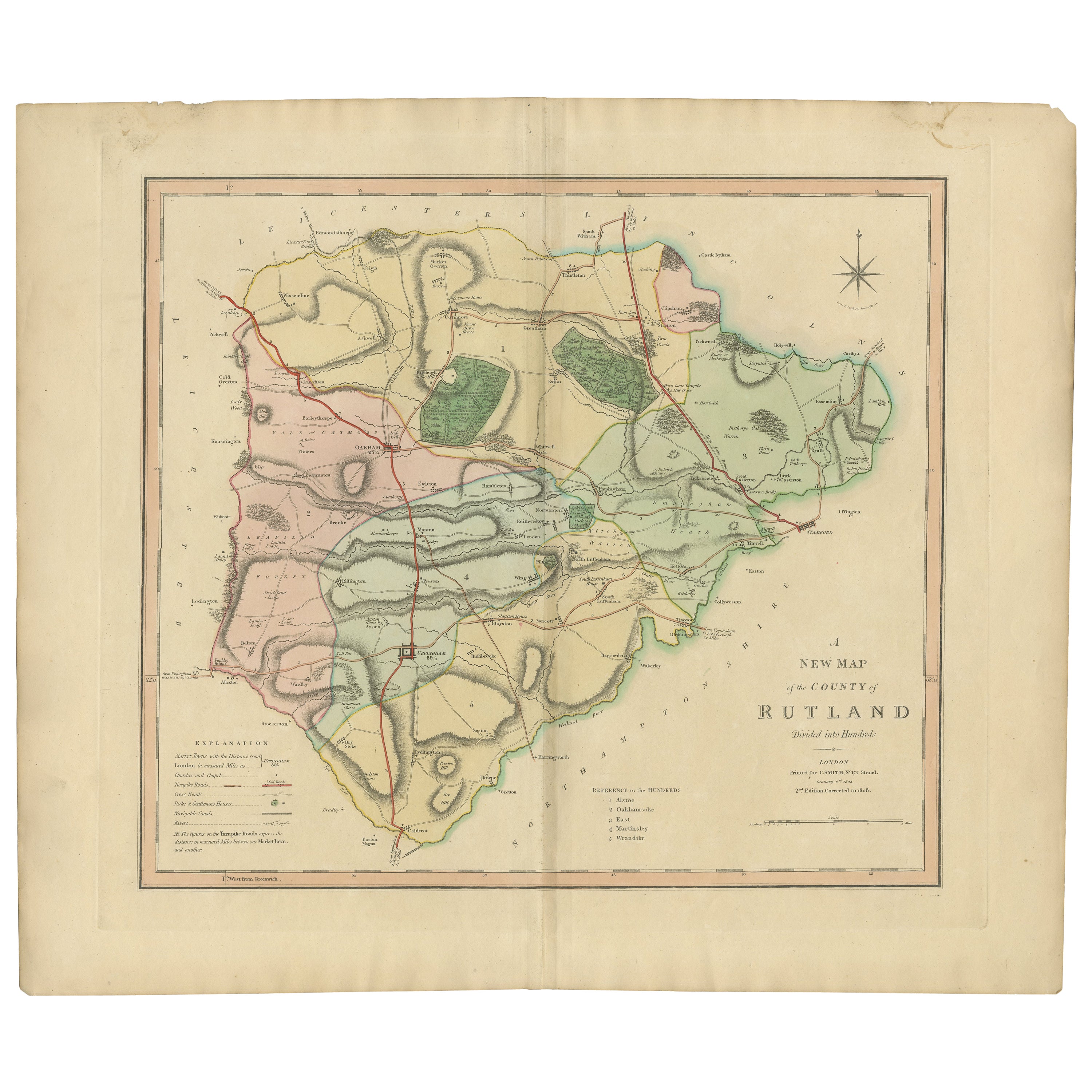
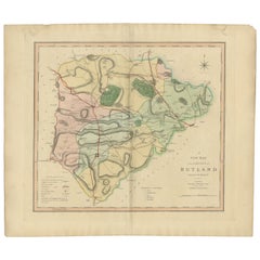
- Antique Hand-Colored County Map of Rutland, England, 1804Located in Langweer, NLAntique county map of Rutland first published c.1800. Villages, towns, and cities illustrated include Oakham, Uppingham, and Normanton. Charles ...Category
Antique Early 1800s Maps
MaterialsPaper
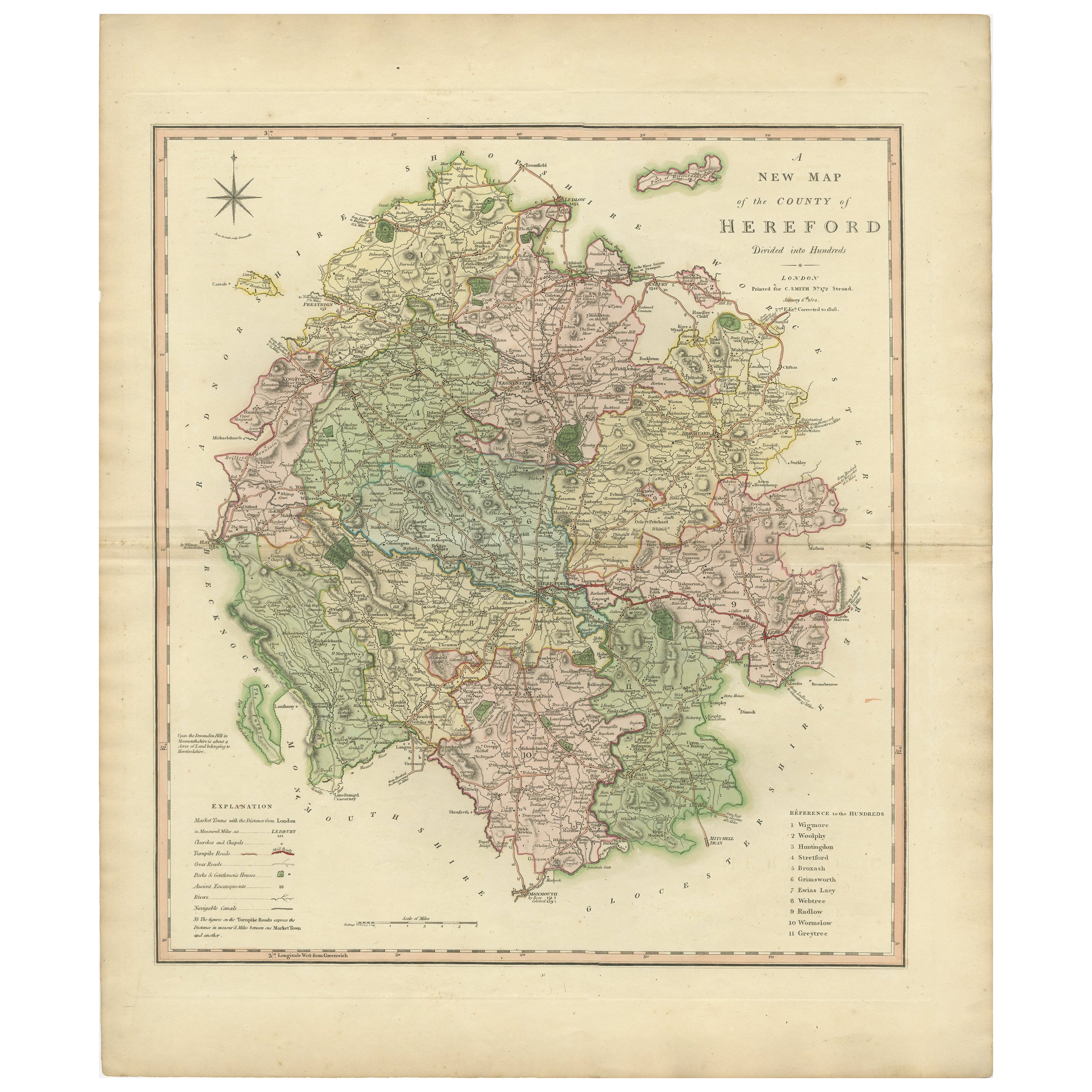
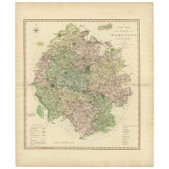
- Original Hand-Colored Antique Map of the County of Hereford in England, 1804Located in Langweer, NLAntique county map of Herefordshire first published c.1800. Villages, towns, and cities illustrated Avenbury, Ashpurton, Kineton, and Bromyard. ...Category
Antique Early 19th Century Maps
MaterialsPaper
- Original Hand-Colored Antique County Map of Durham, England, 1804Located in Langweer, NLAntique county map of Durham first published c.1800. Villages, towns, and cities illustrated include Gateshead, South Shields, and Darlington. C...Category
Antique Early 1800s Maps
MaterialsPaper

You May Also Like
- England, Scotland & Ireland: A Hand Colored Map of Great Britain by TirionBy Isaak TirionLocated in Alamo, CAThis is a hand-colored double page copperplate map of Great Britain entitled "Nieuwe Kaart van de Eilanden van Groot Brittannien Behelzende de Kon...Category
Antique Mid-18th Century Dutch Maps
MaterialsPaper
- Large 17th Century Hand Colored Map of England and the British Isles by de WitBy Frederick de WitLocated in Alamo, CAA large hand colored 17th century map of England and the British Isles by Frederick de Wit entitled "Accuratissima Angliæ Regni et Walliæ Principatus", published in Amsterdam in 1680. It is a highly detailed map of England, Scotland, the Scottish Isles...Category
Antique Late 17th Century Dutch Maps
MaterialsPaper
- 17th Century Hand-Colored Map of Southeastern England by Mercator and HondiusBy Gerard MercatorLocated in Alamo, CAA 17th century copperplate hand-colored map entitled "The Sixt Table of England" by Gerard Mercator and Jodocus Hondius, published in Amsterdam in 1635 in 'Cosmographicall Descriptio...Category
Antique Mid-17th Century Dutch Maps
MaterialsPaper
- Old Horizontal Map of EnglandBy TassoLocated in Alessandria, PiemonteST/520 - Old rare Italian map of England, dated 1826-1827 - by Girolamo Tasso, editor in Venise, for the atlas of M.r Le-Sage.Category
Antique Early 19th Century Italian Other Prints
MaterialsPaper
- Hand-Colored 18th Century Homann Map of the Danube, Italy, Greece, CroatiaBy Johann Baptist HomannLocated in Alamo, CA"Fluviorum in Europa principis Danubii" is a hand colored map of the region about the Danube river created by Johann Baptist Homann (1663-1724) in his 'Atlas Novus Terrarum', publish...Category
Antique Early 18th Century German Maps
MaterialsPaper
- 17th Century Hand Colored Map of the Liege Region in Belgium by VisscherBy Nicolaes Visscher IILocated in Alamo, CAAn original 17th century map entitled "Leodiensis Episcopatus in omnes Subjacentes Provincias distincté divisusVisscher, Leodiensis Episcopatus" by Nicolaes Visscher II, published in Amsterdam in 1688. The map is centered on Liege, Belgium, includes the area between Antwerp, Turnhout, Roermond, Cologne, Trier and Dinant. This attractive map is presented in a cream-colored mat measuring 30" wide x 27.5" high. There is a central fold, as issued. There is minimal spotting in the upper margin and a tiny spot in the right lower margin, which are under the mat. The map is otherwise in excellent condition. The Visscher family were one of the great cartographic families of the 17th century. Begun by Claes Jansz Visscher...Category
Antique Late 17th Century Dutch Maps
MaterialsPaper


