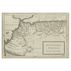

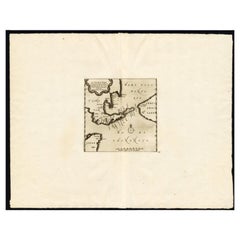
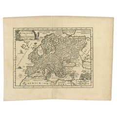
Rare Map of North Africa Depicting Numidia, Libia and Morocco, Published C.1740
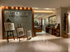
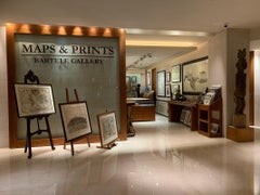
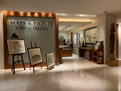
Located in Langweer, NL
Rare map of North Africa depicting Numidia, Libia and Morocco.
Category
1740s French Rare Antique Maps
Materials
Paper
Rare Map of North Africa Depicting Numidia, Libia and Morocco, Published C.1740
Located in Langweer, NL
Rare map of North Africa depicting Numidia, Libia and Morocco.
Paper
$505Sale Price|20% Off
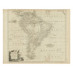
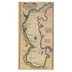
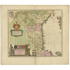
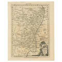
Rare Map of South America of Chili, La Plata, Paraguay, Brazil, Peru, c.1775
Located in Langweer, NL
Rare map of South America depicting Chili, La Plata, Paraguay, Brazil, Peru, the Amazon and surroundings.
Paper
$126Sale Price|20% Off
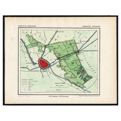
Rare Map of Dutch Municipality Noorddijk Near Groningen, 1865
Located in Langweer, NL
Groningen: Gemeente Engelbert, Middelbert, Noorddijk. These scarse detailed maps of Dutch Towns originate from the 'Gemeente-atlas' of Jacob Kuyper. This atlas of all towns in the Ne...
Paper
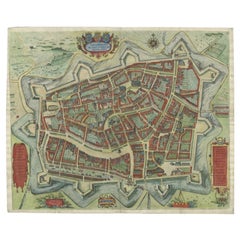

Handcolored Rare Map of Leeuwarden, Capital of Friesland, The Netherlands, 1622
Located in Langweer, NL
Rare and old map of the city of Leeuwarden, Friesland.
Paper
$786Sale Price|20% Off
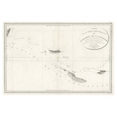
Uncommon Rare Map Showing The Louisiade Archipelago, Papua New Guinea, ca.1798
Located in Langweer, NL
Antique map titled 'Carte de la Partie Septentrionale de l'Archipel de la Louisiade'. Uncommon map showing the area around the Louisiade Archipelago, named for Louis XV by Louis ...
Paper

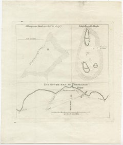
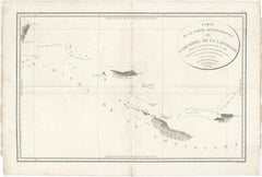
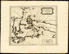
Rare Map of the Philippines; Joseph Freewills Island & Mindanao South End, 1773
Located in Langweer, NL
Three charts on one sheet titled '1) A Dangerous Shoal 2) Joseph Freewills Island 3) The South End of Mindanao'. It shows Captain Carteret's voyage: Saint George's Channel to Min...
Paper
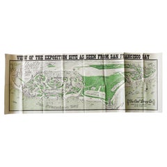
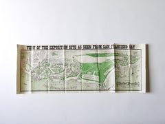
Rare Map San Francisco World’s Fair Exposition Site, 1911, The Owl Drug Co.
Located in Vienna, AT
SAN FRANCISCO View of the Exposition Site as Seen from San Francisco Bay The Owl Drug Co Rare poster map issued for the 1915 San Francisco World’s Fair.
Paper
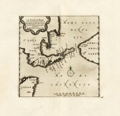
Extremely Rare Map of The land of Eso or Hokkaido in Japan, 1725
Located in Langweer, NL
Depending on the individual map, presentation, and context, a rare or antique map can be modern, traditional, abstract, figurative, serious or whimsical.
Paper
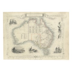
Gold Rush Era Masterpiece: The Tallis & Rapkin Rare Map of Pre-Queensland, 1851
Located in Langweer, NL
The image is an original historical map of Australia from the year 1851, created by John Rapkin with illustrations by J. Marchant and engravings by J. B. Allen. The map was published...
Paper
$1,077Sale Price|20% Off
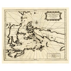
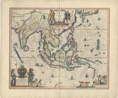
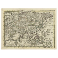
Extremely Rare Map of the East-Indies towards the South-East 'Indonesia', 1725
Located in Langweer, NL
Antique map titled 'La partie des Indes Orientales vers le Zud-Est, depuis Timor jusqu'a Midanao (...).'
Paper
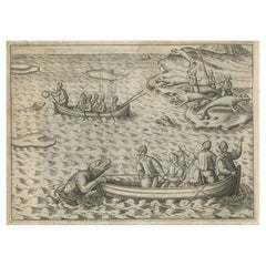
Rare Map of Kildin Island in Russia Plus Engraving of Seal Hunting, 1614
Located in Langweer, NL
Insula Kilduyn. Orig. copper-engraving after details from J. H. van Linschoten's map taken from his account of the three expeditions undertaken by Willem Barents in 1594, in an attem...
Paper

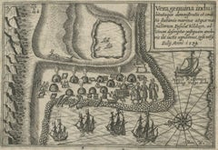
Rare Map of St. Louis on the Island of Hispaniola 'Santa Domingo', 1748
Located in Langweer, NL
Description: Antique map titled 'A New & Exact Planof the Harbour of Port Louis (..)'. Scarce early plan of the Harbor of St. Louis on the Island of Hispaniola (Santa Domingo), s...
Paper

$646Sale Price|20% Off
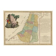
Original Rare Map of the Holy Land Showing the Twelve Tribes of Israel's, 1782
Located in Langweer, NL
Antique map titled 'Carte des Douze Tribus D'Israel (..).' Map of the Holy Land showing the twelve tribes of Israel's. Tribes are all named along with numerous place names, towns...
Paper

$683Sale Price|20% Off
Uncommon and Rare Map of the Caspian Sea by Order of the Czar, 1742
Located in Langweer, NL
Antique map, titled: 'Kaert van de Kaspische Zee volgens bevel van den Czaer (…).' Uncommon map of Caspian Sea. Source unknown, to be determined. Artists and Engravers: Made b...
Paper

$842Sale Price|20% Off
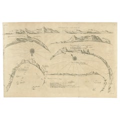
Rare Map of Six Coast Views and Anchorages of Sierra Leone and Indonesia, 1660
Located in Langweer, NL
This rare antique map includes six coastal elevation views of anchorages and bays favored by Dutch and French vessels on their way to Asia.
Paper
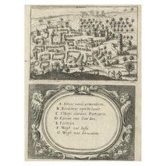
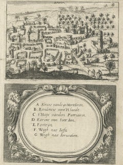
Rare Map of Rama or Ramma 'Ramallah?' in Palestine or the Holy Land, ca.1730
Located in Langweer, NL
Antique map titled 'Rama'. This maps shows a view of Ramma (Ramallah?) in Palestine or the Holy Land. With Dutch legend. Source unknown, to be determined. Artists and Engraver...
Paper
$646Sale Price|20% Off
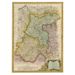
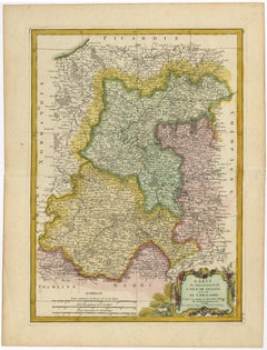
Decorative Rare Map of the French Regions of Isle De France and Orleans, ca.1780
Located in Langweer, NL
Antique map titled 'Carte du Gouvernment de L'Isle de France et de edlui de L'Orleanois (..).' A fine example of Rigobert Bonne's c. 1780 decorative map of the French regions of ...
Paper

$683Sale Price|20% Off
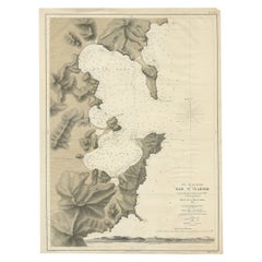
Rare Map of the Bay of St. Vladimir 'Russia' Showing the Route of J. Ward, 1869
Located in Langweer, NL
Antique map titled 'Côte est de Tartarie Baie St. Vladimir'. Map of the Bay of St. Vladimir (Russia) showing the route of J. Ward. Including a coastal view. Source unknown, to be...
Paper

$2,048Sale Price|50% Off
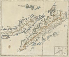
Antique Map of Sumatra, Indonesia 'c.1780'
Located in Langweer, NL
Antique map titled 'Neue Karte von der Insel Sumatra'. Extremely rare map of Sumatra, Indonesia.
Paper


Map Jersey Guernsey Scilly Islands Alderney
Located in BUNGAY, SUFFOLK
Rare map of The Islands of Guernsey and Jersey, including Alderney & the Scilly Islands just purchased more information to follow In the original cream mount and gilded frame.
Paper

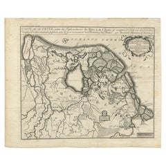
Antique Map of Central Sweden by J. Blaeu, 1662
Located in Langweer, NL
A striking, rare map with a cartouche dedicated to Gabriel Bengtsson Oxenstierna.
Paper


$526Sale Price|40% Off
Antique Map of the Arabian Peninsula by Franceschini, '1739'
Located in Langweer, NL
Antique map titled 'Conventus et Residentiae'. Rare map of the Arabian Peninsula.
Paper

$412Sale Price|20% Off
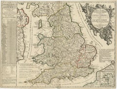
Original Antique Map of England and Wales with Large Cartouche
Located in Langweer, NL
Large and rare map of England and Wales by J.B. Nolin after Coronelli.
Paper

$505Sale Price|20% Off
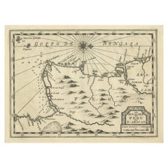
Rare Antique Copper Engraving of a Map of Pegu and Arakan, Burma (Myanmar), 1714
Located in Langweer, NL
Rare map of Pegu and Arakan made after a map engraved by Pieter van den Keere and published in the 1628 edition of the Mercator Atlas Minor.
Paper


Antique Map of the Island of Java, Indonesia by P. Van Der Aa, 1713
Located in Langweer, NL
This rare map shows the Indonesian island of Java. With compass rose and scale.
Paper
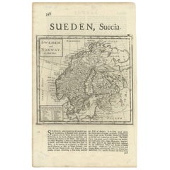

Antique Map of Sweden and Norway by H. Moll, circa 1715
Located in Langweer, NL
Beautiful and rare map of Sweden and Norway including English text.
Paper

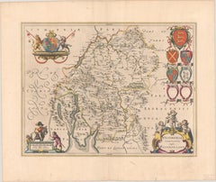
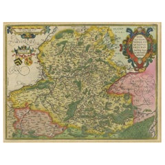
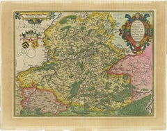
Rare Antique Map of Friesland in Roman Times, Published 1778
Located in Langweer, NL
Par Bernard Schotanus de Sterringa. Rare map illustrating Friesland (The Netherlands).
Paper

$1,123Sale Price|20% Off
Antique Map of the Province of Kilan by Olearius '1662'
Located in Langweer, NL
Rare map of the province of Kilan, near the Caspian Sea.
Paper


Antique Map of Portugal by P. Schenk, circa 1700
Located in Langweer, NL
Antique map titled 'Portugalliae et Algarbia'. Striking example of Schenk's rare map of Portugal, with the coats of arms of Portugal, Algarbia and a Spanish sailing vessell in the ca...
Paper
$2,107Sale Price|20% Off
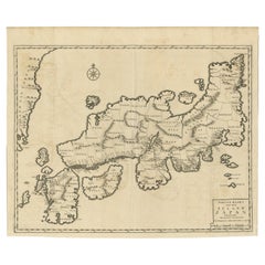
Rare Antique Map of Japan with Place Names Given in Dutch Nomenclature, 1726
Located in Langweer, NL
Rare map of Japan, it shows each of the Japanese provinces, with place names along the route from Nagasaki to Edo.
Paper
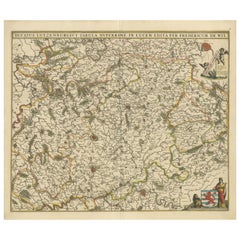
Antique Map of Celtic Europe by Cluver, 1678
Located in Langweer, NL
Rare map of Celtic Europe. Made after A. Ortelius, originates from 'Introductionis in universam geographicarum' by P.
Paper
$639Sale Price|30% Off
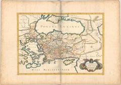
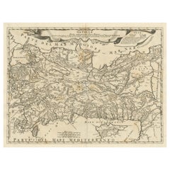
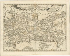
1667 Melchior Tavernier Map of the Patriarchate of Constantinople – Black Sea
Located in Langweer, NL
This rare map offers a unique perspective on the religious influence and historical geography of the Eastern Mediterranean during the late 17th century.
Paper

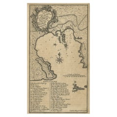
Antique Map of the Coromandel Peninsula, 1754
Located in Langweer, NL
Rare map of Coromandel printed for the London Magazine.
Paper


$324Sale Price|20% Off
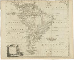
Antique Map of South America by Conder, c.1775
Located in Langweer, NL
Rare map of South America depicting Chili, La Plata, Paraguay, Brazil, Peru, the Amazon and surroundings.
Paper
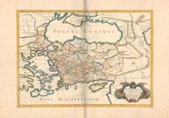
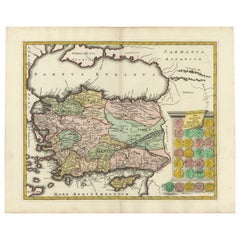
Original Italian Antique Map of Asia Minor, Cyprus, Neighboring Regions, 1686
Located in Langweer, NL
Rare map of Asia Minor (Turkey) and Cyprus and neighboring regions.
Paper

$421Sale Price|20% Off
Antique Map of the Pacific Ocean by Renneville, 1725
Located in Langweer, NL
Depending on the individual map, presentation, and context, a rare or antique map can be modern, traditional, abstract, figurative, serious or whimsical.
Paper


Antique Map of the Maluku Islands by Van der Aa, 1714
By Pieter Van Der Aa
Located in Langweer, NL
Antique Map Moluccas titled 'Les Isles Moluques'. Rare map of the Spice Islands made after a map engraved by Pieter van den Keere and published in the 1628 edition of the Mercator At...
Paper
$1,024Sale Price|30% Off
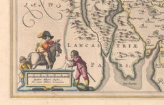
1645 Blaeu Map of Westmorland, Northern England – Hand Colored, Decorative
Located in Langweer, NL
Keywords: Willem Blaeu, Westmorland map, northern England, 17th-century map, antique map, English county map, John Speed, Windermere, decorative cartography, hand-colored map, rare m...
Paper
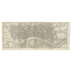

Antique Copper Engraving of Folding Plan of London, Published in 1804
Located in Langweer, NL
This rare map comes originally from the publication: Modern London: Being the History and Present State of the British Metropolis.
Paper

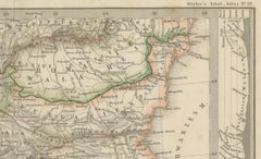
Small Antique Map of the European Turkey, Greece & Ionian Islands – c.1860
Located in Langweer, NL
Avoid glue; use archival corners or hinges for reversibility. Keywords: antique map Greece, Ottoman Empire map, European Turkey map, Ionian Islands, 19th century map, Stieler map, B...
Paper


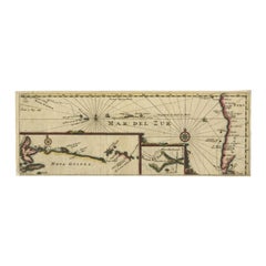
Antique Map of Mar del Sur, Chile, Peru, New Guinea and Tierra del Fuego, 1621
Located in Langweer, NL
Uncommon and rare map of Mar del Sur and the coast of Peru. With inset maps of part of New Guinea and Tierra del Fuego.
Paper
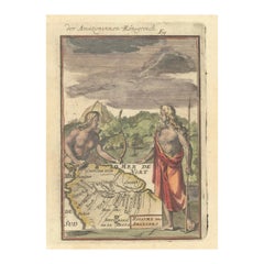
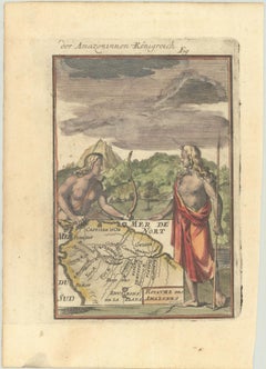
1684 Mallet Map of Amazon River & Kingdom of Amazons – Hand Colored, Miniature
Located in Langweer, NL
Keywords: Alain Manesson Mallet, 1684 map, Royaume des Amazones, Amazon River, South America, mythical maps, Amazon legend, antique map, hand-colored map, miniature map, native Amazo...
Paper


$805Sale Price|20% Off
Antique Map of the Sunda Islands Including Sumatra, Java, and Borneo, 1705
Located in Langweer, NL
Title: “Antique Map of the Sunda Islands Including Sumatra, Java, and Borneo” This print is a beautifully detailed and relatively rare map of Western Indonesia, encompassing the reg...
Paper
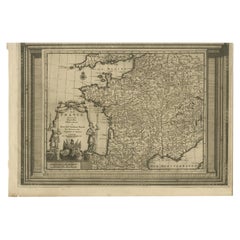

Antique Map of France with Beautiful Title Cartouche and Border, c.1740
Located in Langweer, NL
Rare map of France with beautiful title cartouche and decorative border.
Paper
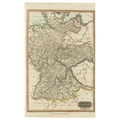
Antique Map of Germany c.1830 by Thomas Kelly – Hand-Coloured Copper Engraving
Located in Langweer, NL
Keywords for SEO: antique map, map of Germany, 1830s map, hand-colored map, Thomas Kelly map, old Germany map, Prussia map, cartography, engraved map, copperplate engraving, historic...
Paper
Original Antique Map of the Duchy of Luxembourg by De Wit, Amsterdam circa 1680
Located in Langweer, NL
Map of the Duchy of Luxembourg by De Wit, Amsterdam circa 1680 Rare original antique map of the Duchy of Luxembourg by Frederick de Wit, published in Amsterdam circa 1680.
Paper
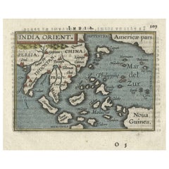
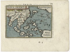
1601 Miniature Map of Southeast Asia & Nova Guinea by Ortelius, Vrients Edition
Located in Langweer, NL
The size and intricate details make it a fascinating and desirable piece for those interested in Ortelius’ work or the cartography of Southeast Asia and the Pacific during the Age of...
Paper

$19,500 / item
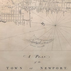
Rare 18th C. Newport Map
Located in Sandwich, MA
Rare 18th C, Map titled "A plan of the town of Newport in the province of Rhode Island".
Paper
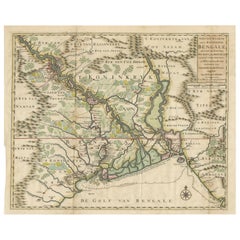
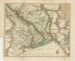
1726 Map of Bengal by Van der Aa after Valentijn – Dutch East Indies
Located in Langweer, NL
Keywords block for your listing: bengal map, van der aa, valentijn map, dutch east india company, voc map, 18th century india map, antique bengal map, orissa map, assam map, tripura ...
Paper
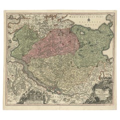
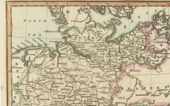
Historical Map of Holstein - Copperplate Engraving by Matthias Seutter, ca. 1730
Located in Langweer, NL
Archival-quality materials ensure the preservation of this rare map for future generations.
Paper

$515Sale Price|20% Off
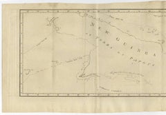
Antique Map of New Guinea and New Britain by P. Carteret, circa 1773
Located in Langweer, NL
Antique Map: A Chart of Captain Carteret's Discoveries at New Britain (1769) This rare and historically significant 18th-century map, titled *A Chart of Captn Carteret's Discoveri...
Paper
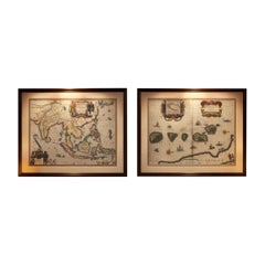
Antique Blaeu Maps, Indonesia & Moluccas – VOC Era, c.1642
Located in Langweer, NL
Antique Blaeu Maps, Indonesia & Moluccas – VOC Era, c.1642 A rare and highly decorative pair of original 17th-century maps by Willem Blaeu, depicting Indonesia and the Moluccas—...
Paper
Hainaut Map Ortelius 1590 – Rare Hand-Colored French-Belgian Border Map
Located in Langweer, NL
Decorative 16th Century Map of Northern France by Ortelius, circa 1590 This richly colored antique map titled *Nobilis Hannoniae Comitatus Descriptio* depicts the County of Hainaut ...
Paper
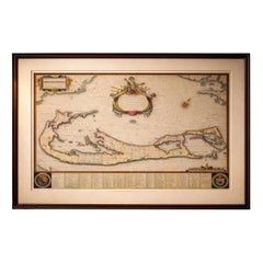
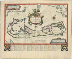
Blaeu Bermuda Map, Somers Isles, Atlantic Chart, Hand-Colored, c.1642
Located in Langweer, NL
The elongated format lends itself well to horizontal placement above a desk or console, or as a refined standalone focal point within a curated wall of early maps. Technique: Copper...
Paper

Rare Hand-Colored Antique Map of Asia, 1788
Located in Langweer, NL
Antique map titled 'Kaartje van Asia'. Original antique map of Asia. This map originates from 'Nieuwe Natuur- Geschied- en Handelkundige Zak- en Reisatlas' by N.T. Gravius, 1788....
Paper
$618Sale Price|20% Off
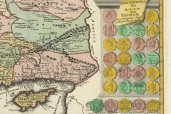
Decorative Antique Map of Cyprus and Asia Minor by Christoph Weigel, Circa 1720
Located in Langweer, NL
Title: Asiae Peninsula sive Asia Intra Taurum by Christoph Weigel, Circa 1720 – Decorative Antique Map of Cyprus and Asia Minor Description: This rare antique map, titled *Asiae Pen...
Paper
$824Sale Price|20% Off
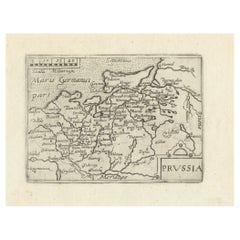
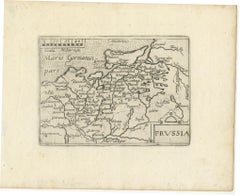
Extremele Rare, Original Miniature Map of Prussia, ca.1640
Located in Langweer, NL
Antique map titled 'Prussia'. Extremele rare, original miniature map of Prussia, a historically prominent German state that originated in 1525 with a duchy centered on the region of ...
Paper