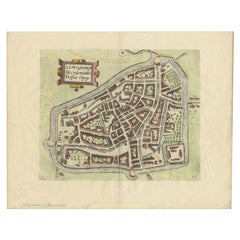

Antique Map of the City of Leeuwarden, The Netherlands, by Guicciardini, 1612
Located in Langweer, NL
We offer a wide range of authentic antique maps for any budget.
Category
17th Century Authentic Antique Maps
Materials
Paper
Antique Map of the City of Leeuwarden, The Netherlands, by Guicciardini, 1612
Located in Langweer, NL
We offer a wide range of authentic antique maps for any budget.
Paper
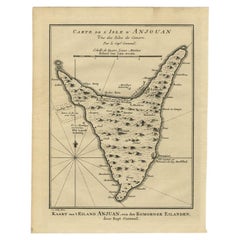

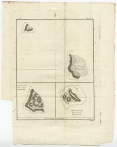
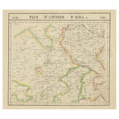
Antique Map of Anjouan or Ndzuani Island, Part of The Comoros, 1749
Located in Langweer, NL
We offer a wide range of authentic antique maps for any budget.
Paper


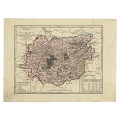
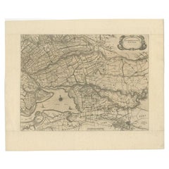
Early Antique Map of Gelderland and Overijssel in the Netherlands, c.1625
Located in Langweer, NL
We offer a wide range of authentic antique maps for any budget.
Paper
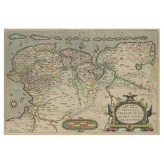
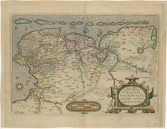
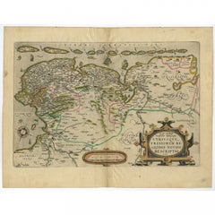
Antique Map of Friesland, Groningen and German East Friesland by Ortelius, 1603
Located in Langweer, NL
We offer a wide range of authentic antique maps for any budget.
Paper

Antique Map of Friesland with Elaborate Cartouche by Mapmaker Ortelius, c.1570
Located in Langweer, NL
We offer a wide range of authentic antique maps for any budget.
Paper


Antique Map of Cities in the Region of Hubei in China, 1758
Located in Langweer, NL
We offer a wide range of authentic antique maps for any budget.
Paper
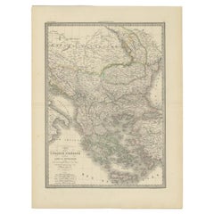
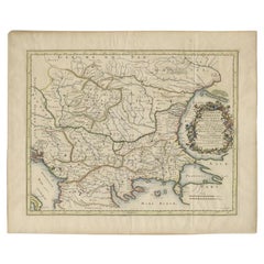
Antique 1842 Map of Turkey and Greece by Pierre M. Lapie, 68x50.5 cm
By Pierre M. Lapie
Located in Langweer, NL
We offer a wide range of authentic antique maps for any budget.
Paper
$205Sale Price|20% Off
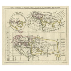
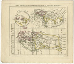
Antique Map of the Old World Projection, Entitled Orbis Terrarum Ad Mentem, 1825
Located in Langweer, NL
We offer a wide range of authentic antique maps for any budget.
Paper


$317Sale Price|20% Off
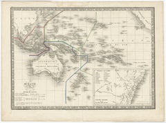
Antique Map of South Australia, Victoria, Queensland and New South Wales, c.1860
Located in Langweer, NL
We offer a wide range of authentic antique maps for any budget.
Paper
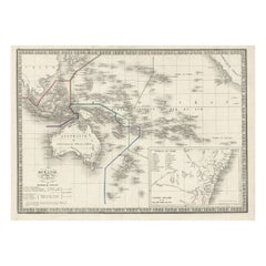
French Antique Map of Oceania with Details of the Australian Colonies, c.1840
Located in Langweer, NL
We offer a wide range of authentic antique maps for any budget.
Paper
$121Sale Price|20% Off
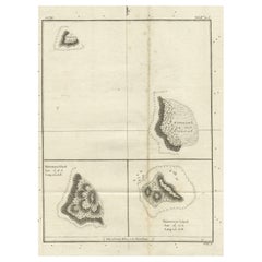
Old Map of the Cook Islands Takutea, Atiu, Mangaiac and Tubuai, Polynesia, 1781
Located in Langweer, NL
We offer a wide range of authentic antique maps for any budget.
Paper
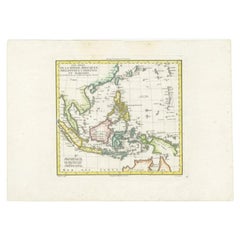

Antique Map of Dutch East Indies (Indonesia) by C.F. Delamarche, Circa 1806
Located in Langweer, NL
We offer a wide range of authentic antique maps for any budget.
Paper
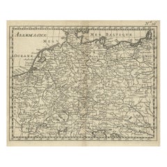
Antique Copper Engraved Map of Germany in the Early 18th Century, c.1740
Located in Langweer, NL
We offer a wide range of authentic antique maps for any budget.
Paper

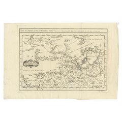
Antique Map of the Region Around the Baltic Sea by Cordier, c.1670
Located in Langweer, NL
We offer a wide range of authentic antique maps for any budget.
Paper

$186Sale Price|20% Off
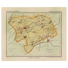
Antique Map of the Township of Ruinen, Drenthe in the Netherlands, circa 1865
Located in Langweer, NL
We offer a wide range of authentic antique maps for any budget.
Paper

$177Sale Price|20% Off
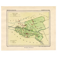
Antique Map of the Township of De Wijk, Drenthe in the Netherlands, 1865
Located in Langweer, NL
We offer a wide range of authentic antique maps for any budget.
Paper

$662Sale Price|20% Off
Large and Rare Antique Map of Northern India in Original Coloring, c.1825
Located in Langweer, NL
We offer a wide range of authentic antique maps for any budget.
Paper

Antique Map of Tibet, The Gobi Desert and China by Bellin, circa 1764
Located in Langweer, NL
We offer a wide range of authentic antique maps for any budget.
Paper
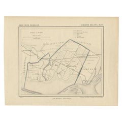

Antique Map of the Region of Rilland and Maire, Zeeland, the Netherlands, 1866
Located in Langweer, NL
We offer a wide range of authentic antique maps for any budget.
Paper
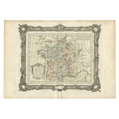

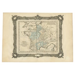
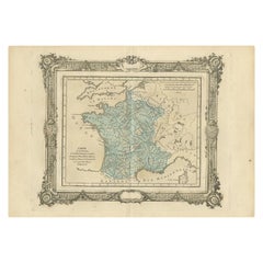
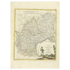
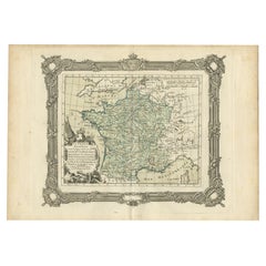
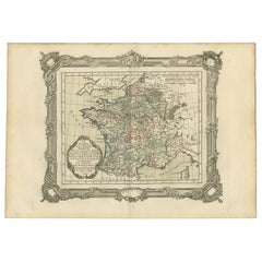
Antique Map of France under the Reign of Philip II by Zannoni, 1765
Located in Langweer, NL
We offer a wide range of authentic antique maps for any budget.
Paper

Antique Map of France under the Reign of Louis XIII by Zannoni, 1765
Located in Langweer, NL
We offer a wide range of authentic antique maps for any budget.
Paper
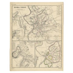
Detailed Original Antique Map of the Region of Rome in Italy, c.1870
By Heinrich Kiepert
Located in Langweer, NL
We offer a wide range of authentic antique maps for any budget.
Paper

Antique Map of the Region of Hainaut and Cambrésis by Reinhardt, c.1784
Located in Langweer, NL
We offer a wide range of authentic antique maps for any budget.
Paper

Antique Map of the Region of Bavaria and Austria by Tirion, c.1740
Located in Langweer, NL
We offer a wide range of authentic antique maps for any budget.
Paper


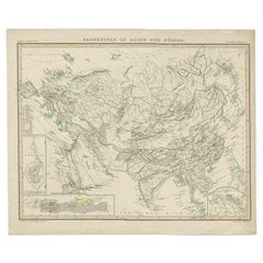
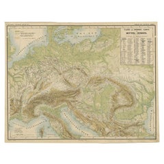
Antique Detailed Map of the Mountain Chains of Europe and Asia, c.1850
Located in Langweer, NL
We offer a wide range of authentic antique maps for any budget.
Paper

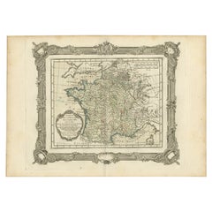
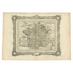
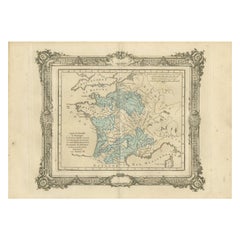
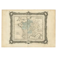
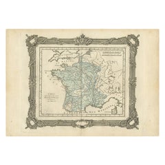
Antique Map of France under the Reign of Philip III by Zannoni, 1765
Located in Langweer, NL
We offer a wide range of authentic antique maps for any budget.
Paper

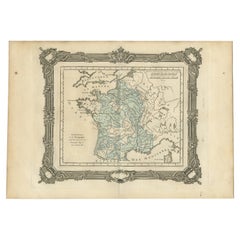
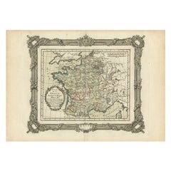
Antique Map of France under the Reign of Louis XI by Zannoni, 1765
Located in Langweer, NL
We offer a wide range of authentic antique maps for any budget.
Paper
Antique Map of France under the Reign of Louis XI by Zannoni, 1765
Located in Langweer, NL
We offer a wide range of authentic antique maps for any budget.
Paper

Antique Map of France under the Reign of Henry IV by Zannoni, 1765
Located in Langweer, NL
We offer a wide range of authentic antique maps for any budget.
Paper

Antique Map of France under the reign of Charles VII by Zannoni, 1765
Located in Langweer, NL
We offer a wide range of authentic antique maps for any budget.
Paper

Antique Map of the Mountain Ranges of Asia and Europe by Berghaus, 1849
Located in Langweer, NL
We offer a wide range of authentic antique maps for any budget.
Paper
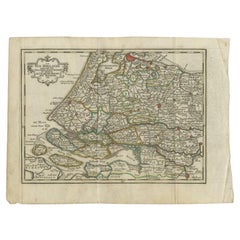

Antique Map of the Province of Zuid-Holland by Keizer & De Lat, 1788
Located in Langweer, NL
We offer a wide range of authentic antique maps for any budget.
Paper

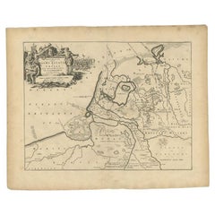
Antique Map of the Old Land of Batavia and Friesland by Halma, 1718
Located in Langweer, NL
We offer a wide range of authentic antique maps for any budget.
Paper

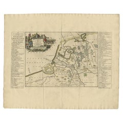
Antique Map of the Old Land of Batavia and FriesLand, The Netherlands, 1697
Located in Langweer, NL
We offer a wide range of authentic antique maps for any budget.
Paper
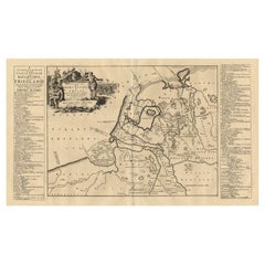

Antique Map of the Old Land of Batavia and Friesland by Halma, 1718
Located in Langweer, NL
We offer a wide range of authentic antique maps for any budget.
Paper
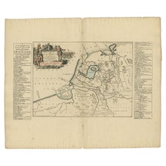

Antique Map of the Old Land of Batavia and FriesLand by Halma, 1718
Located in Langweer, NL
We offer a wide range of authentic antique maps for any budget.
Paper

Antique Map of the Province of Noord-Holland by Keizer & De Lat, 1788
Located in Langweer, NL
We offer a wide range of authentic antique maps for any budget.
Paper

Antique Map of the Province of Brabant in Belgium by Veelwaard, C.1840
Located in Langweer, NL
We offer a wide range of authentic antique maps for any budget.
Paper

Antique Map of the Routes of Jean-françois de Galaup to Asia, 1787
Located in Langweer, NL
We offer a wide range of authentic antique maps for any budget.
Paper

Nice Colourful Antique Map of the Rivers and Mountains of Europe c.1870
By Heinrich Kiepert
Located in Langweer, NL
We offer a wide range of authentic antique maps for any budget.
Paper
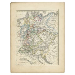

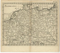
Antique Map of Germany and Switzerland from an Old Dutch School Atlas, 1852
Located in Langweer, NL
We offer a wide range of authentic antique maps for any budget.
Paper

Antique Map of the Region of Bolsward and Sneek by Von Reilly, 1791
Located in Langweer, NL
We offer a wide range of authentic antique maps for any budget.
Paper

$307Sale Price|20% Off
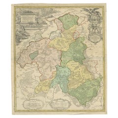
Antique Map of the Waldeck Region of Germany by Homann Heirs, circa 1733
By Homann Heirs
Located in Langweer, NL
We offer a wide range of authentic antique maps for any budget.
Paper
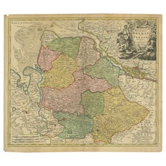

Antique Map of the Duchies of Bremen and Verden by Homann, c.1730
By Johann Baptist Homann
Located in Langweer, NL
We offer a wide range of authentic antique maps for any budget.
Paper

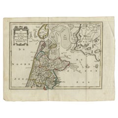
Original Antique Map of Zuid-Holland in the Netherlands by Blaeu, C.1645
Located in Langweer, NL
We offer a wide range of authentic antique maps for any budget.
Paper

Antique Map of the Region of Languedoc, Foix, Roussillon and Rouergue by Zatta
By Antonio Zatta
Located in Langweer, NL
We offer a wide range of authentic antique maps for any budget.
Paper
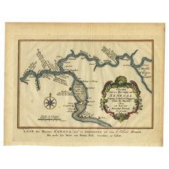

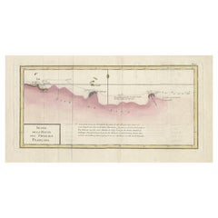
Antique Map of the Course of the Sanaga River by Van Schley, 1747
Located in Langweer, NL
We offer a wide range of authentic antique maps for any budget.
Paper

Antique Map of France under the Reign of Philip II by Zannoni, 1765
Located in Langweer, NL
We offer a wide range of authentic antique maps for any budget.
Paper

Antique Map of France under the Reign of Louis XV by Zannoni, 1765
Located in Langweer, NL
We offer a wide range of authentic antique maps for any budget.
Paper

Antique Map of France under the reign of Henry III by Zannoni, 1765
Located in Langweer, NL
We offer a wide range of authentic antique maps for any budget.
Paper

Antique Map of France under the Reign of Henry III by Zannoni, 1765
Located in Langweer, NL
We offer a wide range of authentic antique maps for any budget.
Paper

Antique Map of Estates of The Year 1669 in Amsterdam, Published c.1767
Located in Langweer, NL
We offer a wide range of authentic antique maps for any budget.
Paper

Antique Map of France under the Reign of Charles VII by Zannoni, 1765
Located in Langweer, NL
We offer a wide range of authentic antique maps for any budget.
Paper

$146Sale Price|20% Off
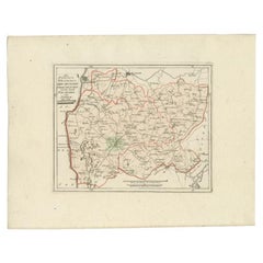
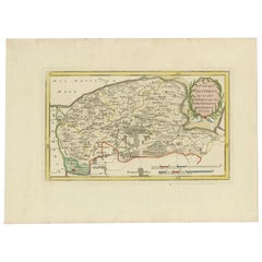
Antique Map of the Region of Leeuwarden and Dokkum in The Netherlands, 1791
Located in Langweer, NL
We offer a wide range of authentic antique maps for any budget.
Paper
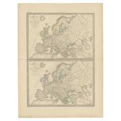
Antique Map of Europe in the Year 800 and 1500, Published in 1842
Located in Langweer, NL
We offer a wide range of authentic antique maps for any budget.
Paper
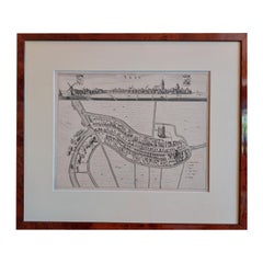
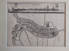
Antique City View and Map of IJlst, City in Friesland, Holland, Framed, 1664
Located in Langweer, NL
We offer a wide range of authentic antique maps for any budget.
Paper
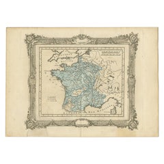

Antique Map of France under the Reign of Charles IX by Zannoni, 1765
Located in Langweer, NL
We offer a wide range of authentic antique maps for any budget.
Paper