Items Similar to Antique Map of Tibet, The Gobi Desert and China by Bellin, circa 1764


Want more images or videos?
Request additional images or videos from the seller
1 of 7
Antique Map of Tibet, The Gobi Desert and China by Bellin, circa 1764
About the Item
Antique map titled 'Carte de l'Empire de Hya et Partie de Tangut'. Old map of Tibet, Gobi desert and China depicting the Great Wall of China and caravan routes. Originates from Prevost d'Exiles influential travel book, 'L'Histoire Generale des Voyages'.
Artists and Engravers: Jacques-Nicolas Bellin (1703-1772) was among the most important mapmakers of the eighteenth century. In 1721, at age 18, he was appointed hydrographer (chief cartographer) to the French Navy. In August 1741, he became the first Ingénieur de la Marine of the Depot des cartes et plans de la Marine (the French Hydrographic Office) and was named Official Hydrographer of the French King.
Condition: Very good, please study image carefully.
Date: circa 1764
Overall size: 40.5 x 27 cm.
Image size: 31 x 22 cm.
We sell original antique maps to collectors, historians, educators and interior decorators all over the world. Our collection includes a wide range of authentic antique maps from the 16th to the 20th centuries. Buying and collecting antique maps is a tradition that goes back hundreds of years. Antique maps have proved a richly rewarding investment over the past decade, thanks to a growing appreciation of their unique historical appeal. Today the decorative qualities of antique maps are widely recognized by interior designers who appreciate their beauty and design flexibility. Depending on the individual map, presentation, and context, a rare or antique map can be modern, traditional, abstract, figurative, serious or whimsical. We offer a wide range of authentic antique maps for any budget.
- Dimensions:Height: 10.63 in (27 cm)Width: 15.95 in (40.5 cm)Depth: 0 in (0.01 mm)
- Materials and Techniques:
- Period:
- Date of Manufacture:circa 1764
- Condition:Condition: Very good, please study image carefully.
- Seller Location:Langweer, NL
- Reference Number:
About the Seller
5.0
Platinum Seller
These expertly vetted sellers are 1stDibs' most experienced sellers and are rated highest by our customers.
Established in 2009
1stDibs seller since 2017
1,929 sales on 1stDibs
Typical response time: <1 hour
- ShippingRetrieving quote...Ships From: Langweer, Netherlands
- Return PolicyA return for this item may be initiated within 14 days of delivery.
More From This SellerView All
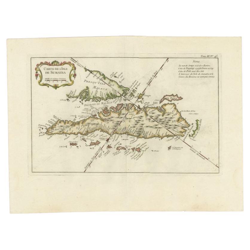
- Antique Map of Sumatra by Bellin, 1764Located in Langweer, NLAntique map Sumatra titled 'Carte de l'Isle de Sumatra'. Old map of Sumatra, Malaysia and the Straits of Malacca, including Singapore. This map originates ...Category
Antique 18th Century Maps
MaterialsPaper
- Antique Map of the Caspian Sea and Surroundings by Bellin, 1764Located in Langweer, NLAntique map titled 'Carte de la Mer Caspienne et ses Environs'. Old map depicting the region of the Caspian Sea. This map originates from 'Le Petit Atlas M...Category
Antique 18th Century Maps
MaterialsPaper
- Antique Map of the Mouth of the Yangtze River 'China' by J.N. Bellin, 1764Located in Langweer, NLThis detailed regional map of China is a historical cartographic work from the mid-18th century and is attributed to Antoine-François Prévost, a prominent French cartographer and geo...Category
Antique Mid-18th Century Maps
MaterialsPaper
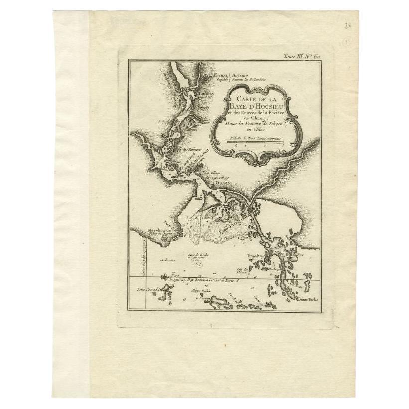
- Antique Map of the Mouth of the Chiang River by Bellin, 1764By Jacques-Nicolas BellinLocated in Langweer, NLAntique map titled ‘Carte de la Baye d'Hocsieu et des Entrees de la Riviere de Chang, Dans la Province de Fokyen en Chine’. This impressive map or sea chart d...Category
Antique 18th Century Maps
MaterialsPaper
- Antique Map of Boulogne-sur-Mer by Bellin '1764'Located in Langweer, NLAntique map titled 'Plan de la Ville de Boulogne'. Original antique map of Boulogne-sur-Mer, France. This map originates from 'Le petit atlas maritime: recueil de cartes et plans des...Category
Antique Mid-18th Century Maps
MaterialsPaper
- Antique Map of the Tonkin River ‘Vietnam’ by J.N. Bellin, 1764Located in Langweer, NLOne of the maps produced by Bellin for Prevost d'Exiles' influential travel book, ‘L'Histoire Generale des Voyages’. This map depicts part of Southeast Asia, most likely northern Vie...Category
Antique Mid-18th Century Maps
MaterialsPaper


You May Also Like
- Captain Cook's Exploration of Tahiti 18th C. Hand-Colored Map by BellinBy Jacques-Nicolas BellinLocated in Alamo, CAThis beautiful 18th century hand-colored copper plate engraved map is entitled "Carte de l'Isle de Taiti, par le Lieutenant J. Cook" was created by Jacques Nicolas Bellin and publish...Category
Antique Mid-18th Century French Maps
MaterialsPaper
- Super Rare Antique French Map of Chine and the Chinese Empire, 1780Located in Amsterdam, Noord HollandSuper Rare Antique French Map of Chine and the Chinese Empire, 1780 Very nice map of Asia. 1780 Made by Bonne. Additional information: Type: Map ...Category
Antique 18th Century European Maps
MaterialsPaper
- Original Antique Map of China by Thomas Clerk, 1817Located in St Annes, LancashireGreat map of China Copper-plate engraving Drawn and engraved by Thomas Clerk, Edinburgh. Published by Mackenzie And Dent, 1817 Unframed.Category
Antique 1810s English Maps
MaterialsPaper
- 1861 Topographical Map of the District of Columbia, by Boschke, Antique MapLocated in Colorado Springs, COPresented is an original map of Albert Boschke's extremely sought-after "Topographical Map of the District of Columbia Surveyed in the Years 1856 ...Category
Antique 1860s American Historical Memorabilia
MaterialsPaper
- Original Antique Map of China, Arrowsmith, 1820Located in St Annes, LancashireGreat map of China Drawn under the direction of Arrowsmith Copper-plate engraving Published by Longman, Hurst, Rees, Orme and Brown, 1820 Unfr...Category
Antique 1820s English Maps
MaterialsPaper
- "Clason's Guide Map of Montana" by The Clason Map Company, Circa 1920sLocated in Colorado Springs, COPresented is “Clason's Guide Map of Montana,” published in the early 1920s by the Clason Map Company. Issued as a folding map, this map identifies county boundaries, county seats, Na...Category
Vintage 1920s American Art Deco Maps
MaterialsPaper


Recently Viewed
View AllMore Ways To Browse
Vintage Butcher Shop Posters
Papua New Guinea Antique Map
Montenegro Antique Map
Australasia Antique Map
Buenos Ayres
Carte Egypte Antique
Charlotte Reine
The Grand Mogol
Antique Map Colorado
William Dampier
Antique Map Of Lapland
Mauritius Antique Map
Dan Rizzi
Antique Map Austro Hungarian
Formosa Vintage Map
Georgetown Map
Guatemala Antique Map
Manchester Antique Map