Items Similar to Antique Map of the Old World Projection, Entitled Orbis Terrarum Ad Mentem, 1825


Want more images or videos?
Request additional images or videos from the seller
1 of 6
Antique Map of the Old World Projection, Entitled Orbis Terrarum Ad Mentem, 1825
About the Item
Antique map titled 'Orbis Terrarum ad Mentem (..)'. Old map of the world originating from 'Atlas der Oude Wereld'.
Artists and Engravers: Published by C. Ph. Funke and W. van Boekeren, Groningen.
Condition: Very good, general age-related toning. Please study image carefully.
Date: 1825
Overall size: 24.8 x 21.6 cm.
Image size: 19.8 x 17.2 cm.
We sell original antique maps to collectors, historians, educators and interior decorators all over the world. Our collection includes a wide range of authentic antique maps from the 16th to the 20th centuries. Buying and collecting antique maps is a tradition that goes back hundreds of years. Antique maps have proved a richly rewarding investment over the past decade, thanks to a growing appreciation of their unique historical appeal. Today the decorative qualities of antique maps are widely recognized by interior designers who appreciate their beauty and design flexibility. Depending on the individual map, presentation, and context, a rare or antique map can be modern, traditional, abstract, figurative, serious or whimsical. We offer a wide range of authentic antique maps for any budget.
- Dimensions:Height: 8.51 in (21.6 cm)Width: 9.77 in (24.8 cm)Depth: 0 in (0.01 mm)
- Materials and Techniques:
- Period:
- Date of Manufacture:1825
- Condition:Condition: Very good, general age-related toning. Please study image carefully.
- Seller Location:Langweer, NL
- Reference Number:
About the Seller
5.0
Platinum Seller
These expertly vetted sellers are 1stDibs' most experienced sellers and are rated highest by our customers.
Established in 2009
1stDibs seller since 2017
1,928 sales on 1stDibs
Typical response time: <1 hour
- ShippingRetrieving quote...Ships From: Langweer, Netherlands
- Return PolicyA return for this item may be initiated within 14 days of delivery.
More From This SellerView All
- Antique Map of the World on Mercator's Projection, 1788Located in Langweer, NLAntique map titled 'Kaart van de Geheele Wereld (..)'. Uncommon small world map on Mercator's projection. Nice detail of the islands throughout the wor...Category
Antique Late 18th Century Maps
MaterialsPaper
- Antique Map of the World, Mercator Projection, by Wyld, '1845'Located in Langweer, NLAntique map titled 'The World'. Original antique world map, on Mercator's projection. This map originates from 'An Atlas of the World, Compr...Category
Antique Mid-19th Century Maps
MaterialsPaper
- Antique Map of the World with Polar Projections by Keizer & de Lat, 1788Located in Langweer, NLAntique map titled 'Schuine Ronde Aard-Klooten (..)'. Interesting double hemisphere world map with polar projections. In North America, there is a...Category
Antique Late 18th Century Maps
MaterialsPaper
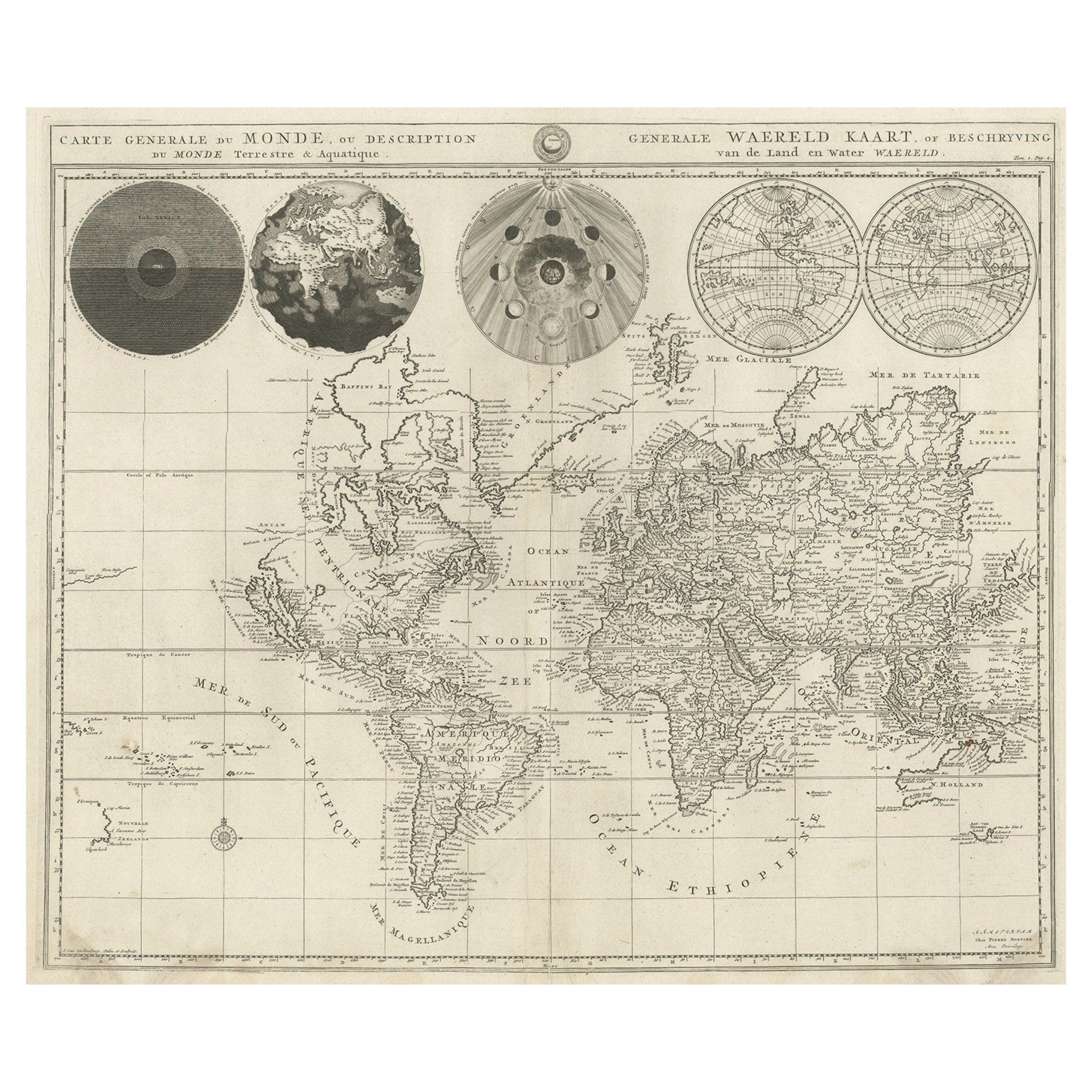
- Antique Detailed World Map Drawn on Mercator's Projection, 1700Located in Langweer, NLAntique world map titled 'Carte generale du monde, ou description du monde terrestre & Aquatique - Generale Waereld kaart, of beschryving van de land en water waereld'. This is Pierr...Category
Antique 17th Century Maps
MaterialsPaper
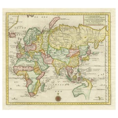
- Antique Map of the Eastern Part of the WorldLocated in Langweer, NLAntique map titled 'Nieuwe Kaart van het Oostelykste Deel der Weereld, diendende tot aanwyzing van de Scheepstogten der Nederlanderen Naar Oostindie'. This finely engraved map of the...Category
Antique Mid-18th Century Maps
MaterialsPaper
- Antique Map of the World by Balbi '1847'Located in Langweer, NLAntique map titled 'Planisphère'. Original antique map of the world. This map originates from 'Abrégé de Géographie (..)' by Adrien Balbi. Pub...Category
Antique Mid-19th Century Maps
MaterialsPaper


You May Also Like
- Original Antique Map of The World by Thomas Clerk, 1817Located in St Annes, LancashireGreat map of The Eastern and Western Hemispheres On 2 sheets Copper-plate engraving Drawn and engraved by Thomas Clerk, Edinburgh. Published by Mackenzie And Dent, 1817 ...Category
Antique 1810s English Maps
MaterialsPaper
- Old Nautical Map of CorsicaLocated in Alessandria, PiemonteST/556/1 - Old map of Corsica isle, surveyed by Captain Hell, of the French Royal Navy in 1824, engraved and published on 1874, with additions and corre...Category
Antique Early 19th Century English Other Prints
MaterialsPaper
- Old Horizontal Map of EnglandBy TassoLocated in Alessandria, PiemonteST/520 - Old rare Italian map of England, dated 1826-1827 - by Girolamo Tasso, editor in Venise, for the atlas of M.r Le-Sage.Category
Antique Early 19th Century Italian Other Prints
MaterialsPaper
- Novissima Totius Terrarum Orbis Tabula Map After Nicolaes Visscher Burled FrameBy Nicolaes Visscher IILocated in Dayton, OHA stately print after Nicolaes Visscher's Novissima Totius Terrarum Orbis Tabula Map. Neatly framed in burlwood. Dimensions: 39" x 1" x 33" / Sans Frame - 28" x 22" (Width x Dept...Category
Late 20th Century Prints
MaterialsPaper
- Map of the Republic of GenoaLocated in New York, NYFramed antique hand-coloured map of the Republic of Genoa including the duchies of Mantua, Modena, and Parma. Europe, late 18th century. Dimension: 25...Category
Antique Late 18th Century European Maps
- Antique Map of Principality of MonacoBy Antonio Vallardi EditoreLocated in Alessandria, PiemonteST/619 - "Old Geographical Atlas of Italy - Topographic map of ex-Principality of Monaco" - ediz Vallardi - Milano - A somewhat special edition ---Category
Antique Late 19th Century Italian Other Prints
MaterialsPaper


Recently Viewed
View AllMore Ways To Browse
Old World Furniture
Old World Design
Antique Old World
Antique Old World Furniture
Ad Design
Used Nautical Charts
Antique World Chart
Antique Char
Map Of Great Britain
Antique Furniture Depot
Hand Painted Antique Map
Antique Map Mexico
Hemisphere Antiques
Antique Mexico Map
17th Century Scottish
Antique Road Maps
Antique Road Map
Antique Map Of Mexico