
Mercator Map

to
33
83
42
104
78
25
22
22
21
18
14
10
10
9
7
5
4
4
3
2
2
2
2
2
2
1
1
1
1
1
1
44
2
2
2
1
Sort By
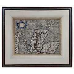
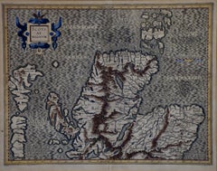
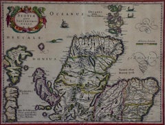
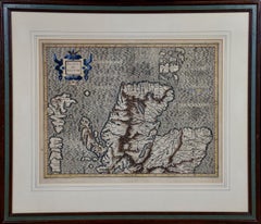
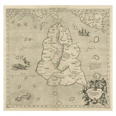
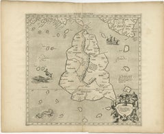
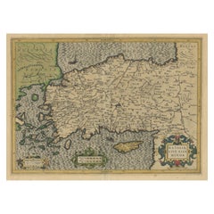
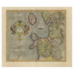
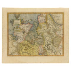
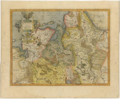
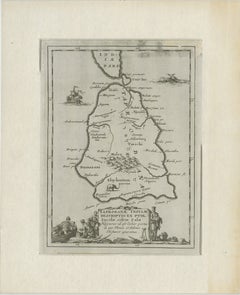
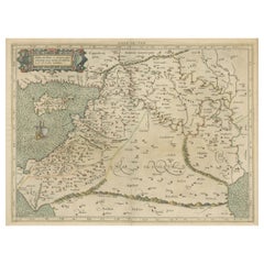
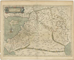
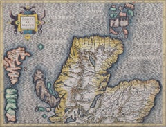
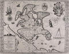
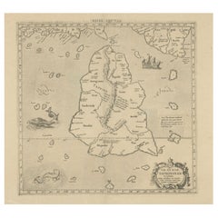
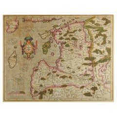
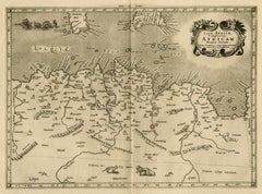
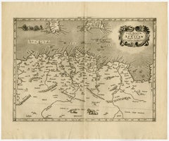
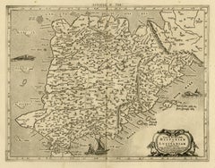
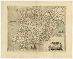
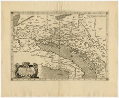
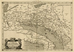
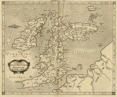
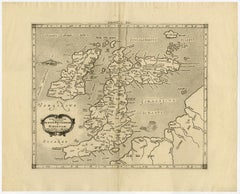
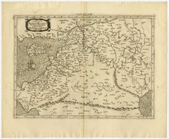
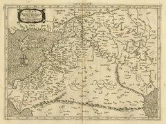
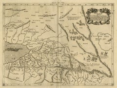
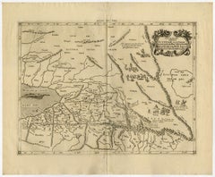
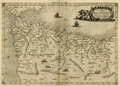
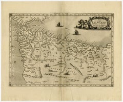
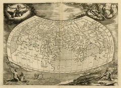
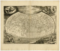
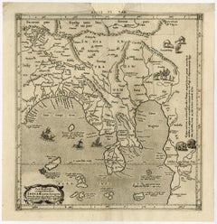
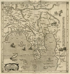
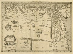
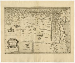
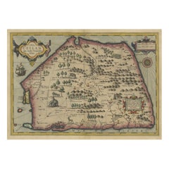
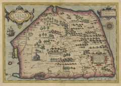
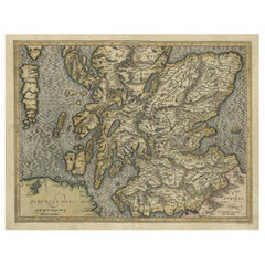
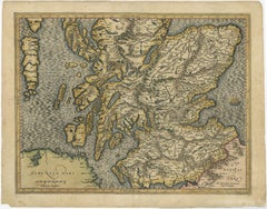
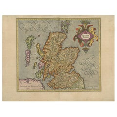
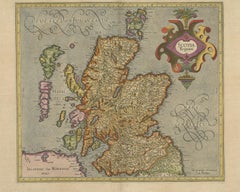
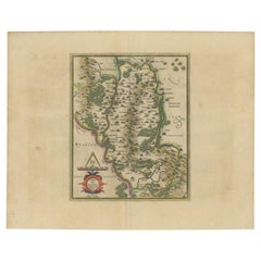
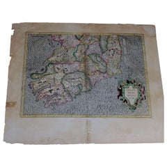
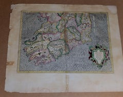
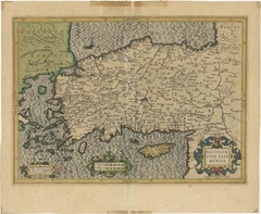
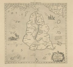
1585 Mercator Map of Ireland, Entitled "Irlandiae Regnvm, " Hand Colored Ric0006
Located in Norton, MA
1585 Mercator map of Ireland, entitled "Irlandiae Regnvm." Hand Colored Description
Category

Antique 16th Century Dutch Maps

Materials

Paper

1625 Mercator Map of the Provenience of Quercy, "Quercy Cadvrcivm Ric.0013
Located in Norton, MA
1625 Mercator map of the provenience of Quercy, entitled "Quercy Cadvrcivm," Ric.0013
Category

Antique 17th Century French Maps

Materials

Paper

1590 Mercator Map Entitled "France Picardie Champaigne, Ric.0001
Located in Norton, MA
Description: Published in Amsterdam by Mercator/Hondius ca. 1590. Ric.0001 Artists and
Category

Antique 16th Century Dutch Maps

Materials

Paper

Antique Map of the Southern Lorraine Region by Mercator, c.1625
By Gerard Mercator
Located in Langweer, NL
Antique map titled 'Lotharingiae Ducatus'. Old map of the southern portion of the Lorraine region
Category

Antique 17th Century Maps

Materials

Paper

Antique Map of the Southern Lorraine Region by Mercator, c.1625
$278 Sale Price
20% Off
H 18.12 in W 22.05 in D 0 in
Northern Scotland: 17th Century Hand-colored Map by Mercator
By Gerard Mercator
Located in Alamo, CA
This is a framed hand-colored 17th century map of Northern Scotland by Gerard Mercator entitled
Category

Mid-17th Century Other Art Style Landscape Prints

Materials

Engraving

Northern Scotland: 16th Century Hand-colored Map by Mercator
By Gerard Mercator
Located in Alamo, CA
This is a framed hand-colored 16th century map of Northern Scotland by Gerard Mercator entitled
Category

16th Century Other Art Style Landscape Prints

Materials

Engraving

Mercator's Ptolemaic map of Taprobana, (Ceylon) Sri Lanka
Located in Langweer, NL
Antique map titled 'Asiae XII Tab'. Mercator's Ptolemaic map of Taprobana. The map shows Ptolemy's
Category

Antique 16th Century Maps

Materials

Paper

Mercator's Ptolemaic map of Taprobana, (Ceylon) Sri Lanka
$557 Sale Price
20% Off
H 15.95 in W 20.01 in D 0.02 in
Framed Mercator Hondius Hispania Nova Atlas Minor Map
Located in Stamford, CT
a copy of the original german text on verso. The miniature version of the Mercator Hondius map of
Category

Antique 17th Century Dutch Spanish Colonial Maps

Materials

Glass, Wood, Paper

Antique Map of Styria by Mercator 'circa 1650'
Located in Langweer, NL
Antique map titled 'Stiria'. Original antique map of Styria, Austria. Published by G. Mercator
Category

Antique Mid-17th Century Maps

Materials

Paper

Antique Map of Styria by Mercator 'circa 1650'
$432 Sale Price
20% Off
H 16.15 in W 20.87 in D 0.02 in
Original Antique Map of Turkey, Asia Minor and Cyprus
By Gerard Mercator
Located in Langweer, NL
Antique map titled 'Natoliae sive Asia Minor'. Original old map of Turkey, Asia Minor and Cyprus
Category

Antique Early 17th Century Maps

Materials

Paper

Original Antique Map of Turkey, Asia Minor and Cyprus
$807 Sale Price
20% Off
H 17.13 in W 20.95 in D 0.02 in
Antique Map of Northeastern Spain by Mercator, 1634
Located in Langweer, NL
Antique map titled 'Biscaia, Guipiscoa, Navarra et Asturias de Santillana'. Charming map of
Category

Antique 17th Century Maps

Materials

Paper

Antique Map of Northeastern Spain by Mercator, 1634
$133 Sale Price
20% Off
H 7.05 in W 8.51 in D 0 in
Mercator's Ptolemaic Map of Ancient Assyria, Media, and Persia
Located in Langweer, NL
1595 by his family. This map is a vivid representation of Mercator’s craftsmanship and Ptolemy's
Category

Antique 16th Century Maps

Materials

Paper

Mercator's Ptolemaic Map of Ancient Assyria, Media, and Persia
$1,095 Sale Price
20% Off
H 15.36 in W 20.87 in D 0 in
Antique Map of England by Mercator/Hondius, circa 1600
Located in Langweer, NL
popularization of a projection which now bears his name. On Mercator projection maps, all parallels and meridians
Category

Antique 16th Century Maps

Materials

Paper

Antique Map of England by Mercator/Hondius, circa 1600
$913 Sale Price
20% Off
H 18.12 in W 21.66 in D 0.02 in
Antique Map of the World on Mercator's Projection, 1788
Located in Langweer, NL
Antique map titled 'Kaart van de Geheele Wereld (..)'. Uncommon small world map on Mercator
Category

Antique Late 18th Century Maps

Materials

Paper

Antique Map of the World on Mercator's Projection, 1788
$720 Sale Price
20% Off
H 8.08 in W 12.8 in D 0.02 in
Antique Mercator Projection World Map by Petri, c.1873
Located in Langweer, NL
Antique world map titled 'Wereldkaart naar Mercator's Projectie'. Old map of the world. This map
Category

Antique 19th Century Maps

Materials

Paper

Antique Mercator Projection World Map by Petri, c.1873
$120 Sale Price
20% Off
H 10.32 in W 12.84 in D 0 in
Map of Avenches Region Switzerland by Mercator, Original 1585 Engraving
Located in Langweer, NL
Map of Wiflispurgergov by Gerardus Mercator, Avenches Region, 1585 This rare and finely engraved
Category

Antique 16th Century Dutch Maps

Materials

Paper

1884 Antique Decorative World Map – Mercator Projection, Victorian Era Print
Located in Langweer, NL
Antique World Map on Mercator’s Projection – Black’s Atlas, 1884 This finely engraved and colored
Category

Antique 1880s Scottish Maps

Materials

Paper

1634 Mercator/Jansson Map: Eastern Austria with Vienna, Hand-Colored
Located in Langweer, NL
1634 Mercator/Jansson Map: Eastern Austria with Vienna, Hand-Colored This hand-colored map from
Category

Antique 1630s Maps

Materials

Paper

1634 Mercator/Jansson Map: Eastern Austria with Vienna, Hand-Colored
$538 Sale Price
20% Off
H 5.6 in W 7.4 in D 0.002 in
1698 Mercator Ptolemaic Map of Asia East of the Ganges
Located in Langweer, NL
historical companion to his modern atlas. **Artists and Engravers:** The map was created by Gerard Mercator
Category

Antique 1680s Maps

Materials

Paper

1698 Mercator Ptolemaic Map of Asia East of the Ganges
$903 Sale Price
20% Off
H 16.93 in W 15.83 in D 0.01 in
Antique Map of Westfalia, Germany by Mercator/Hondius, circa '1620'
Located in Langweer, NL
by Mercator/Hondius, circa '1620' 17th Century antique detailled map of Westphalia, East Friesland
Category

Antique 16th Century Maps

Materials

Paper

Antique Map of Westfalia, Germany by Mercator/Hondius, circa '1620'
$913 Sale Price
20% Off
H 17.72 in W 21.66 in D 0.02 in
Antique Map of the World, Mercator Projection, by Wyld, '1845'
Located in Langweer, NL
Antique map titled 'The World'. Original antique world map, on Mercator's projection. This map
Category

Antique Mid-19th Century Maps

Materials

Paper

Antique Map of the World, Mercator Projection, by Wyld, '1845'
$336 Sale Price
20% Off
H 10.24 in W 14.18 in D 0.02 in
World Map – Mercator Projection with Global Sea Routes, Published in 1857
Located in Langweer, NL
World Map – Mercator Projection with Global Sea Routes 1857 This attractive antique print shows a
Category

Antique Mid-19th Century German Maps

Materials

Paper

Colorful Detailed Antique Map of The World on Mercators Projection, 1882
Located in Langweer, NL
The 'World of Mercator's Projection' is a map with a stunning portrayal of global geography and
Category

Antique 1880s Maps

Materials

Paper

Colorful Detailed Antique Map of The World on Mercators Projection, 1882
$240 Sale Price
20% Off
H 14.97 in W 22.45 in D 0 in
Antique Map of the Northeast of England by Mercator 'circa 1620'
Located in Langweer, NL
Antique map titled 'Eboracum Lincolnia, Derbia, Staffordia, Notinghamia, Lecestria, Rutlandia, et
Category

Antique Early 17th Century Maps

Materials

Paper

Antique Map of the Northeast of England by Mercator 'circa 1620'
$528 Sale Price
20% Off
H 16.34 in W 21.07 in D 0.02 in
1864 Johnson's Map of the World on Mercator's Projection, Ric.B009
Located in Norton, MA
An 1864 Johnson's map of the World on Mercator's Projection Ric.b009 About this Item
Category

Antique 19th Century Dutch Maps

Materials

Paper

Antique Map of the World on Mercator Projection by Anson, 1749
Located in Langweer, NL
'. Original antique map of the world on Mercator's Projection from a Dutch edition of Anson's voyages. The map
Category

Antique 18th Century Maps

Materials

Paper

Antique Map of the World on Mercator Projection by Anson, 1749
$441 Sale Price
25% Off
H 10.63 in W 16.74 in D 0 in
Map of Zurich and Basel Region by Mercator, Uncolored Engraving c.1600
Located in Langweer, NL
Map of Zurich and Basel Region by Mercator, Uncolored Engraving c.1600 This original uncolored
Category

Antique Early 17th Century Maps

Materials

Paper

Antique World Map on Mercator's Projection, Ocean Currents and Trade Routes 1903
Located in Langweer, NL
Title: Antique World Map on Mercator's Projection, 1903, Showing Ocean Currents and Trade Routes
Category

Early 20th Century Maps

Materials

Paper

Mercator's Ptolemaic Map of the Holy Land, Cyprus and Syria, circa 1580
Located in Langweer, NL
Antique map titled 'Asiae IIII Tab'. Beautiful map of Mercator's Ptolemaic map of the Holy Land
Category

Antique 16th Century Maps

Materials

Paper

Mercator's Ptolemaic Map of the Holy Land, Cyprus and Syria, circa 1580
$663 Sale Price
20% Off
H 15.63 in W 19.77 in D 0.02 in
17th-Century Map of Sri Lanka (Ceylon) by Mercator & van den Keere, 1630
Located in Langweer, NL
Petrus Kaerius (van den Keere) and published in Mercator's "Atlas Minor," edited by Cloppenburgh. The map
Category

Antique 1630s Maps

Materials

Paper

Exploring Ancient Persia: Ptolemaic Map of Iran and Iraq by Ptolemy and Mercator
Located in Langweer, NL
verso with an alternate title: Asiae Tabula Quinta. Mercator originally published this map in his 1578
Category

Antique 1610s Maps

Materials

Paper

Ancient Course of the Ganges: A First Ptolemaic Map of India by Mercator, c.1584
Located in Langweer, NL
hallmark of the finest sixteenth and seventeenth-century Dutch maps, largely attributed to Mercator
Category

Antique 16th Century Maps

Materials

Paper

Antique Map of the Area Around Venice in Italy by H. Hondius, circa 1606
By Jodocus Hondius, Gerard Mercator
Located in Langweer, NL
Attractive and early map of the area around Venice, Italy. With South-Tirol in the North, areas of
Category

Antique Early 17th Century Dutch Maps

Materials

Paper

Map of the North of Scotland 17th century hand-coloured map by Gerardus Mercator
Located in London, GB
Gerardus Mercator (1512 - 1594) Map of the North of Scotland (1683) Engraving with later hand
Category

1680s Prints and Multiples

Materials

Engraving

West Africa: A 17th Century Hand-Colored Map by Mercator/Hondius
By Gerard Mercator
Located in Alamo, CA
A 17th century hand-colored map entitled "Guineae Nova Descriptio" by Gerard Mercator and Jodocus
Category

1630s Landscape Prints

Materials

Engraving

Original Antique Map of the Northern Baltic Region
Located in Langweer, NL
. Published by the renowned cartographer Gerardus Mercator circa 1620, this map offers valuable insights into
Category

Antique Early 17th Century Maps

Materials

Paper

Original Antique Map of the Northern Baltic Region
$951 Sale Price
20% Off
H 18.98 in W 23.15 in D 0.02 in
1633 Map Entitled "Beauvaisis Comitatus Belova Cium, Ric.0002
Located in Norton, MA
. To meet this competition Hondius added about 40 maps to Mercator\\\\\\\\\\\\\\\'s original number and
Category

Antique 17th Century Dutch Maps

Materials

Paper

Antique Ptolemaic Map of Ceylon or nowadays Sri Lanka
Located in Langweer, NL
book of maps, one of Mercator's life works was a corrected and improved edition of maps based upon the
Category

Antique Mid-18th Century Maps

Materials

Paper

Antique Ptolemaic Map of Ceylon or nowadays Sri Lanka
$663 Sale Price
20% Off
H 19.3 in W 22.92 in D 0.02 in
Circa 1659 Willem Blaeu Map: Southwestern Switzerland with Geneva & Lakes
Located in Langweer, NL
, Lake Biel, Bern, Freiburg, and Lake Thuner. Based on the work of Gerard Mercator, this map is
Category

Antique 1650s Maps

Materials

Paper

Circa 1659 Willem Blaeu Map: Southwestern Switzerland with Geneva & Lakes
$1,191 Sale Price
20% Off
H 15.1 in W 19.9 in D 0.002 in
Southeastern Ireland: A 17th Century Hand Colored Map by Mercator and Hondius
By Gerard Mercator
Located in Alamo, CA
Carlow. This region has an interesting history which led to Mercator producing a map focused on it. When
Category

1630s Landscape Prints

Materials

Engraving

Rugen Island, Germany: An Early 17th Century Map by Mercator and Hondius
By Gerard Mercator
Located in Alamo, CA
" (Map of Rugen Island, Germany) by Gerard Mercator and Henricus and Joducus Hondius, published in
Category

Early 17th Century Old Masters Landscape Prints

Materials

Engraving

Southeastern England: A 17th Century Hand-Colored Map by Mercator and Hondius
By Gerard Mercator
Located in Alamo, CA
A 17th century copperplate hand-colored map entitled "The Sixt Table of England" by Gerard Mercator
Category

1630s Landscape Prints

Materials

Engraving

1592 Abraham Ortelius Map "Lorraine: Lotharingiae Nova Descripti, Ric.A005
Located in Norton, MA
maps found in Mercator's "Galliae tabulae Geographicae." On the back of the map is a description in
Category

Antique 16th Century Dutch Maps

Materials

Paper

Antique Map of Delfland and Schieland by Hondius, c.1630
Located in Langweer, NL
. Henricus obtained the original plates of the Mercator 1569 world map, and published a 1606 version of it
Category

Antique 17th Century Maps

Materials

Paper

Antique Map of Delfland and Schieland by Hondius, c.1630
$793 Sale Price
20% Off
H 18.51 in W 22.64 in D 0 in
1616 Petrus Kaerius Map of Southern India and Ceylon – Narsinga et Ceylon
Located in Langweer, NL
scholars, preceding Blaeu’s and Mercator’s popular works. Maps from this series remain prized for their
Category

Antique Early 17th Century German Maps

Materials

Paper

1597 Abraham Ortelius Map Burgundy, France Entitled "Bvrgvndiae dvcatvs Ric.a010
Located in Norton, MA
maps found in Mercator's "Galliae tabulae Geographicae." On the back of the map is a description in
Category

Antique 16th Century Dutch Maps

Materials

Paper

Rare Original Antique Ptolemy Map of Ceylon, Present Day Sri Lanka
Located in Langweer, NL
Original antique map titled 'Tab XII Asiae Taprobanam (..)'. For this map of Toprobana (Sri Lanka
Category

Antique Late 17th Century Maps

Materials

Paper

Rare Original Antique Ptolemy Map of Ceylon, Present Day Sri Lanka
$740 Sale Price
20% Off
H 15.56 in W 20.67 in D 0.02 in
Decorative Early Hand-Colored Map of the Northeast of England, ca.1620
Located in Langweer, NL
popularization of a projection which now bears his name. On Mercator projection maps, all parallels and meridians
Category

Antique 1620s Maps

Materials

Paper

Decorative Early Hand-Colored Map of the Northeast of England, ca.1620
$644 Sale Price
20% Off
H 18.9 in W 22.25 in D 0 in
Map of Le Maine by H. Hondius, 1633, Hand-Colored, Decorative and Historic
Located in Langweer, NL
Mercator, this map belongs to the famous 'Atlas Novus'. Its combination of aesthetic beauty and historical
Category

Antique 1630s Maps

Materials

Paper

Very Attractive Antique Map of the World as Planisphere, Shows Cook's Voyages
Located in Langweer, NL
Antique map titled 'Chart of the World, according to Mercators Projection'. This world map shows
Category

Antique Late 18th Century Maps

Materials

Paper

Very Attractive Antique Map of the World as Planisphere, Shows Cook's Voyages
$1,351 Sale Price
25% Off
H 16.15 in W 20.08 in D 0.02 in
Antique World Map with Astronomical Spheres by Pierre Mortier, Amsterdam, c.1700
Located in Langweer, NL
Mortier in Amsterdam around 1700. It is a richly detailed and ambitious map engraved on Mercator
Category

Antique 17th Century French Maps

Materials

Paper

Antique Map of Australia, New Zealand and Oceania by F. von Stülpnagel, 1850
Located in Langweer, NL
Antique map titled 'Australien und Polynesien in Mercators Projection'. A map of Australia, New
Category

Antique Mid-19th Century Maps

Materials

Paper

Antique Map of Australia, New Zealand and Oceania by F. von Stülpnagel, 1850
$185 Sale Price
30% Off
H 15.16 in W 18.31 in D 0.02 in
1612 Abraham Ortelius, Entitled "Lorraine, Lotharingiae, Nova Desciptio, " Ric008
Located in Norton, MA
map of Lorraine is based on maps found in Mercator's "Galliae tabulae Geographicae." On the back of
Category

Antique 17th Century Dutch Maps

Materials

Paper

California: 18th Century Hand-colored Map by de Vaugondy
By Didier Robert de Vaugondy
Located in Alamo, CA
Mercator (1512-1594). The main portions of the map depicts the west coast of North America from Present
Category

1770s Landscape Prints

Materials

Engraving

North & South America: A 17th Century Hand-colored Map by Jansson & Goos
By Johannes Jansson
Located in Alamo, CA
Abraham Goos. The map is based on an earlier map by Gerardus Mercator. There are many misconceptions about
Category

1620s Landscape Prints

Materials

Engraving

Nova Totius Terrarum Orbis Geographica Ac Hydrographica Tabula
Located in New York, NY
. Image size 15.75 x 21.19 inches (40 x 53.9 cm). A classic example of a world map based on Mercator
Category

17th Century Other Art Style More Art

Materials

Engraving

Northern Scotland: A 17th Century Hand-colored Map by Mercator
By Gerard Mercator
Located in Alamo, CA
This is a framed hand-colored 17th century map of Northern Scotland by Gerard Mercator entitled
Category

Antique 1630s Dutch Maps

Materials

Paper

Northern Scotland: A 16th Century Hand-colored Map by Mercator
By Gerard Mercator
Located in Alamo, CA
A framed hand-colored 16th century map of Northern Scotland by Gerard Mercator entitled "Scotiae
Category

Antique 16th Century Dutch Maps

Materials

Paper

  • 1
Get Updated with New Arrivals
Save "Mercator Map", and we’ll notify you when there are new listings in this category.

Mercator Map For Sale on 1stDibs

Find many varieties of an authentic mercator map available at 1stDibs. Frequently made of paper, enamel and glass, every mercator map was constructed with great care. There are many kinds of the mercator map you’re looking for, from those produced as long ago as the 18th Century to those made as recently as the 20th Century. A well-made mercator map has long been a part of the offerings for many furniture designers and manufacturers, but those produced by Johannes Janssonius, Gerard Mercator and Abraham Ortelius are consistently popular.

How Much is a Mercator Map?

A mercator map can differ in price owing to various characteristics — the average selling price 1stDibs is $650, while the lowest priced sells for $136 and the highest can go for as much as $135,000.