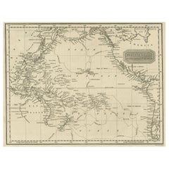
Antique Map of Captain Cook's Voyages, 1824
View Similar Items


Want more images or videos?
Request additional images or videos from the seller
1 of 6
Antique Map of Captain Cook's Voyages, 1824
About the Item
- Dimensions:Height: 8.27 in (21 cm)Width: 10.44 in (26.5 cm)Depth: 0 in (0.01 mm)
- Materials and Techniques:
- Period:
- Date of Manufacture:1824
- Condition:Condition: Good, few defects lower margin. General age-related toning, please study image carefully.
- Seller Location:Langweer, NL
- Reference Number:Seller: BGJC-1841stDibs: LU3054329625062
About the Seller
5.0
Platinum Seller
These expertly vetted sellers are 1stDibs' most experienced sellers and are rated highest by our customers.
Established in 2009
1stDibs seller since 2017
1,916 sales on 1stDibs
More From This SellerView All
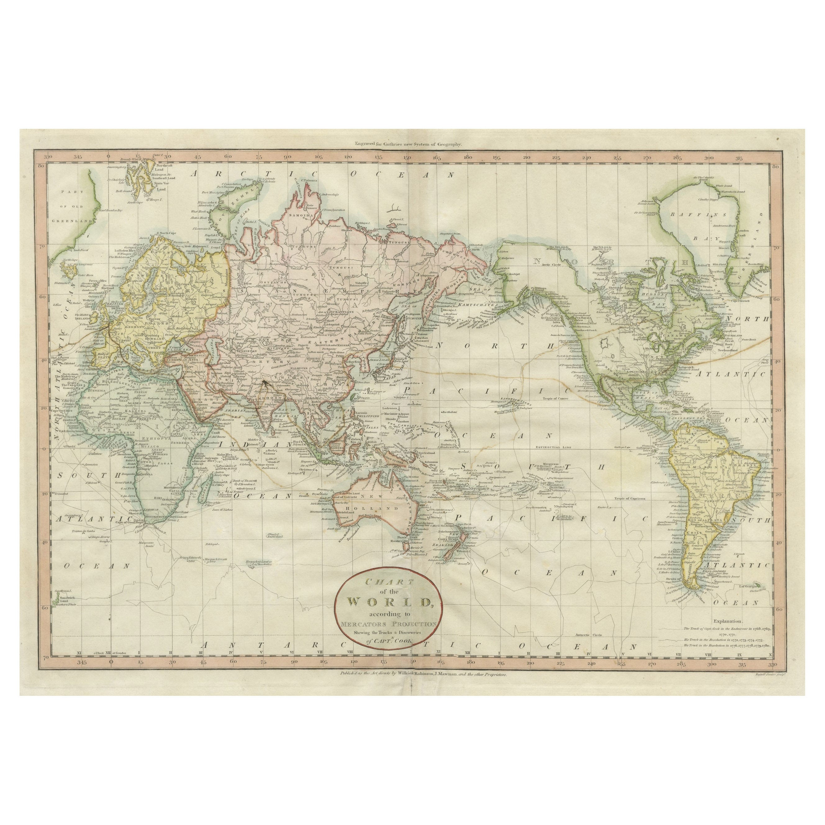
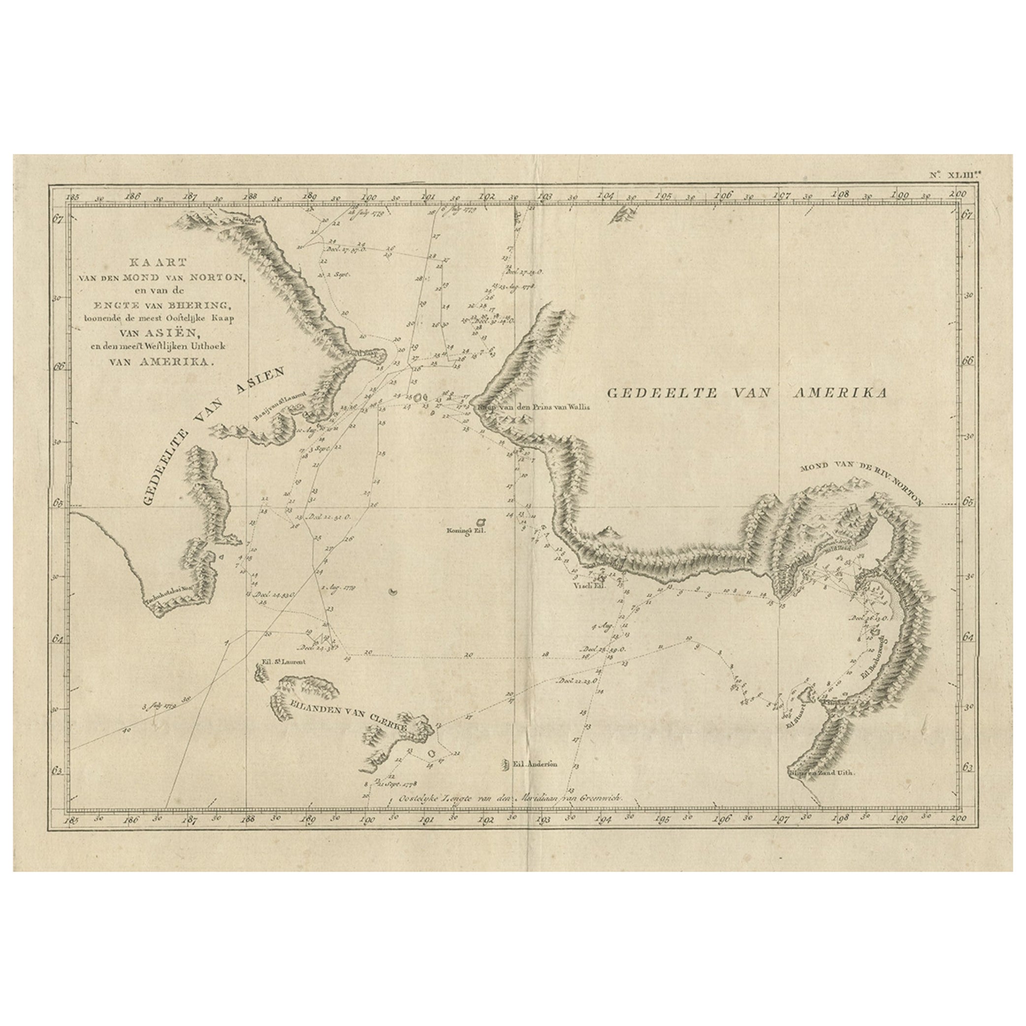
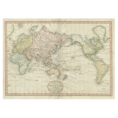
- Very Attractive Antique Map of the World as Planisphere, Shows Cook's VoyagesLocated in Langweer, NLAntique map titled 'Chart of the World, according to Mercators Projection'. This world map shows the various discoveries of Captain James Cook during his 3 voyages between 1768 and 1780, and the English and French Explorers who followed immediately thereafter, including Vancouver and La Perouse. This edition of the map is significantly revised from the editions issued immediately after the official report of Cook's Voyages were integrated into the map, showing better detail in New Zealand, Australia, the Northwest Coast of America and North East coast of Asia, along with Greenland. A new large lake also appears for the first time in the Western part of North America, shortly before the commencement of the Lewis...Category
Antique Late 18th Century Maps
MaterialsPaper
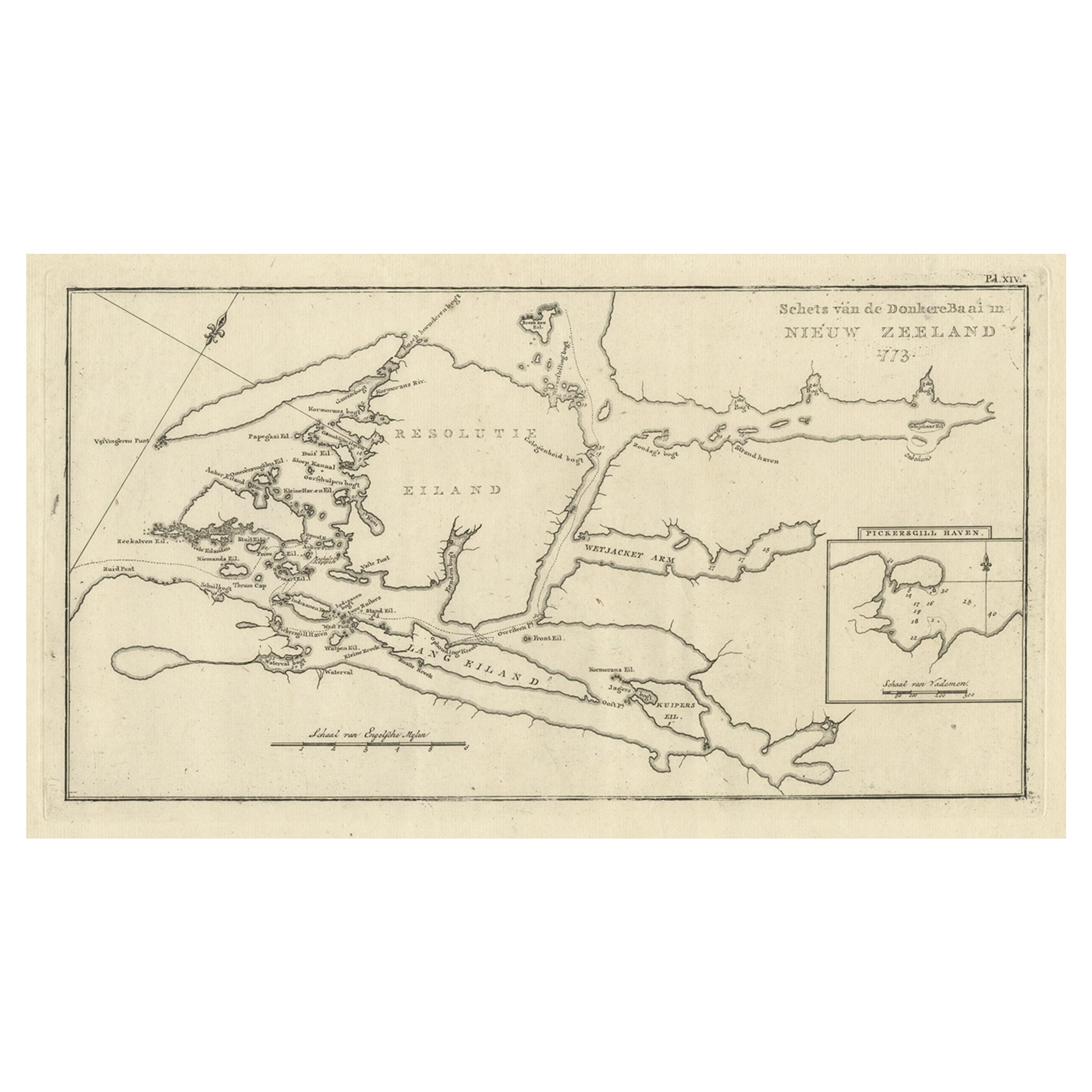
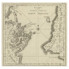
- Antique Map of Cook's Strait in New Zealand, 1803Located in Langweer, NLAntique map New Zealand titled 'Kaart van Cooks Straat in Nieuw Zeeland'. Antique map of Cook's Strait in New Zealand. Originates from 'Reizen ...Category
Antique 19th Century Maps
MaterialsPaper
 $567 Sale Price20% Off
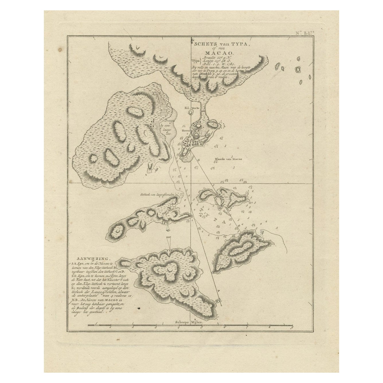
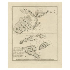
 - Antique Map of Macao and Surroundings by Captain Cook, 1803Located in Langweer, NLAntique map Macao titled 'Schets van Typa of van Macao'. Map of Macao and surrounding islands. Originates from 'Reizen Rondom de Waereld door James Cook (..)'. Artists and Engravers:...Category
Antique 19th Century Maps
MaterialsPaper
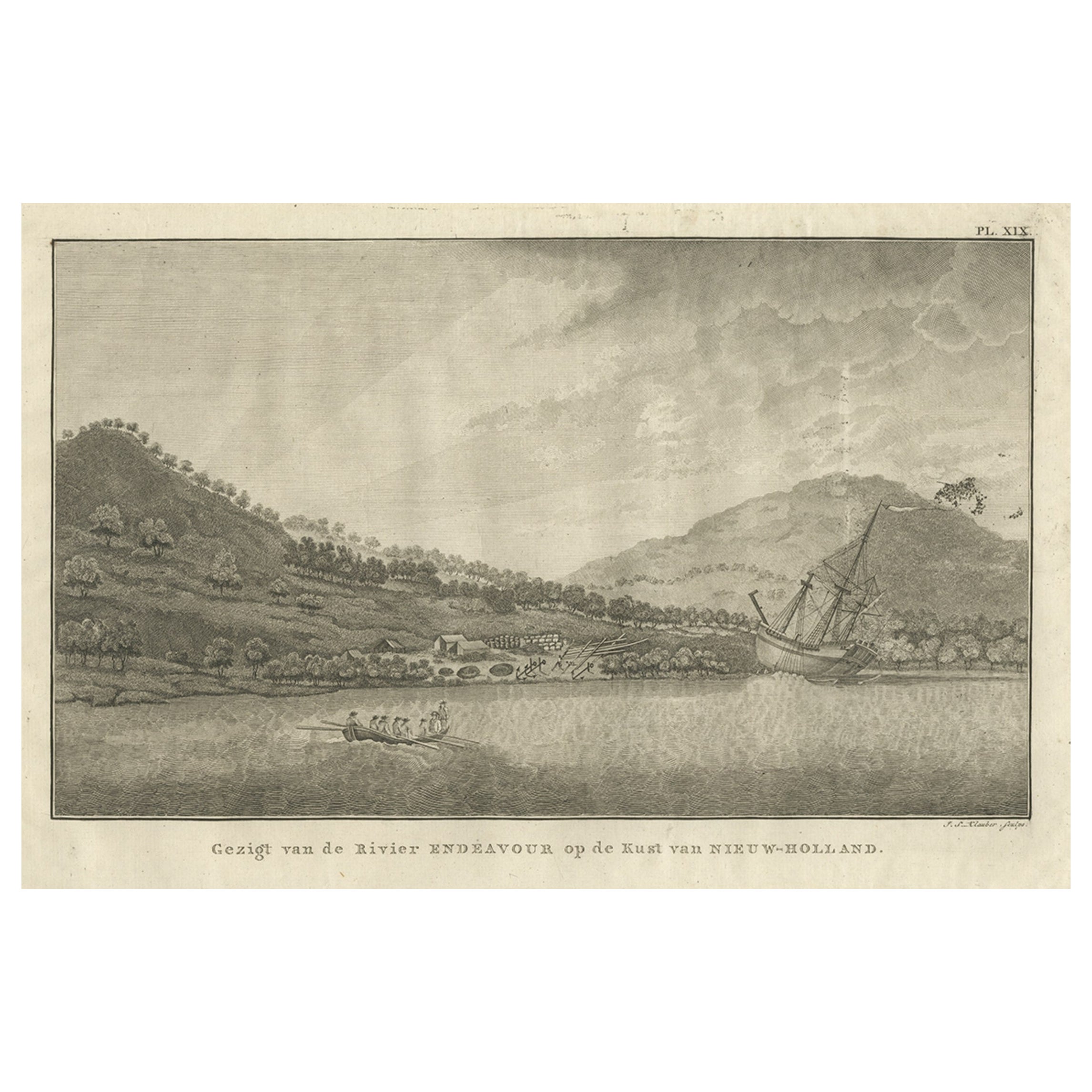
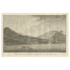
- Captain Cook's Encampment in Australia where The Endeavour was Beached, 1803Located in Langweer, NLAntique print Australia titled 'Gezigt van de Rivier Endeavour op de Kust van Nieuw-Holland'. View of an encampent on the shore of the Endeavour river on the coast of Australia where the Endeavour boat was beached. Originates from 'Reizen Rondom de Waereld door James Cook (..)'. HMS Endeavour was a British Royal Navy research vessel that Lieutenant James Cook commanded to Australia and New Zealand on his first voyage of discovery from 1768 to 1771. She was launched in 1764 as the collier Earl of Pembroke, with the Navy purchasing her in 1768 for a scientific mission to the Pacific Ocean and to explore the seas for the surmised Terra Australis Incognita or "unknown southern land". Commissioned as His Majesty's Bark Endeavour, she departed Plymouth in August 1768, rounded Cape Horn and reached Tahiti in time to observe the 1769 transit of Venus across the Sun. She then set sail into the largely uncharted ocean to the south, stopping at the islands of Huahine, Bora Bora, and Raiatea west of Tahiti to allow Cook to claim them for Great Britain. In September 1769, she anchored off New Zealand, becoming the first European vessel to reach the islands since Abel Tasman's Heemskerck 127 years earlier. In April 1770, Endeavour became the first European ship to reach the east coast of Australia, with Cook going ashore at what is now known as Botany Bay. Endeavour then sailed north along the Australian coast. She narrowly avoided disaster after running aground on the Great Barrier Reef, and Cook had to throw her guns overboard to lighten her. Endeavour was beached on the Australian mainland for seven weeks to permit rudimentary repairs to her hull. Resuming her voyage, she limped into port in Batavia in October 1770, her crew sworn to secrecy about the lands that they had visited. From Batavia Endeavour continued westward, rounded the Cape of Good Hope on 13 March 1771 and reached the English port of Dover on 12 July, having been at sea for nearly three years. The ship was largely forgotten after her Pacific voyage, spending the next three years hauling troops and cargo to and from the Falkland Islands. She was renamed in 1775 after being sold into private hands, and used to transport timber from the Baltic. Rehired as a British troop transport during the American War of Independence, she was finally scuttled in a blockade of Narragansett Bay, Rhode Island in 1778. Historical evidence indicates the ship was sunk just north of Goat Island in Newport Harbor, along with four other British transports. Relics from Endeavour are displayed at maritime museums worldwide, including an anchor and six of her cannon. A replica of Endeavour was launched in 1994 and is berthed alongside the Australian National Maritime Museum in Sydney Harbour. The NASA Space Shuttle...Category
Antique Early 1800s Prints
MaterialsPaper
 $597 Sale Price24% Off
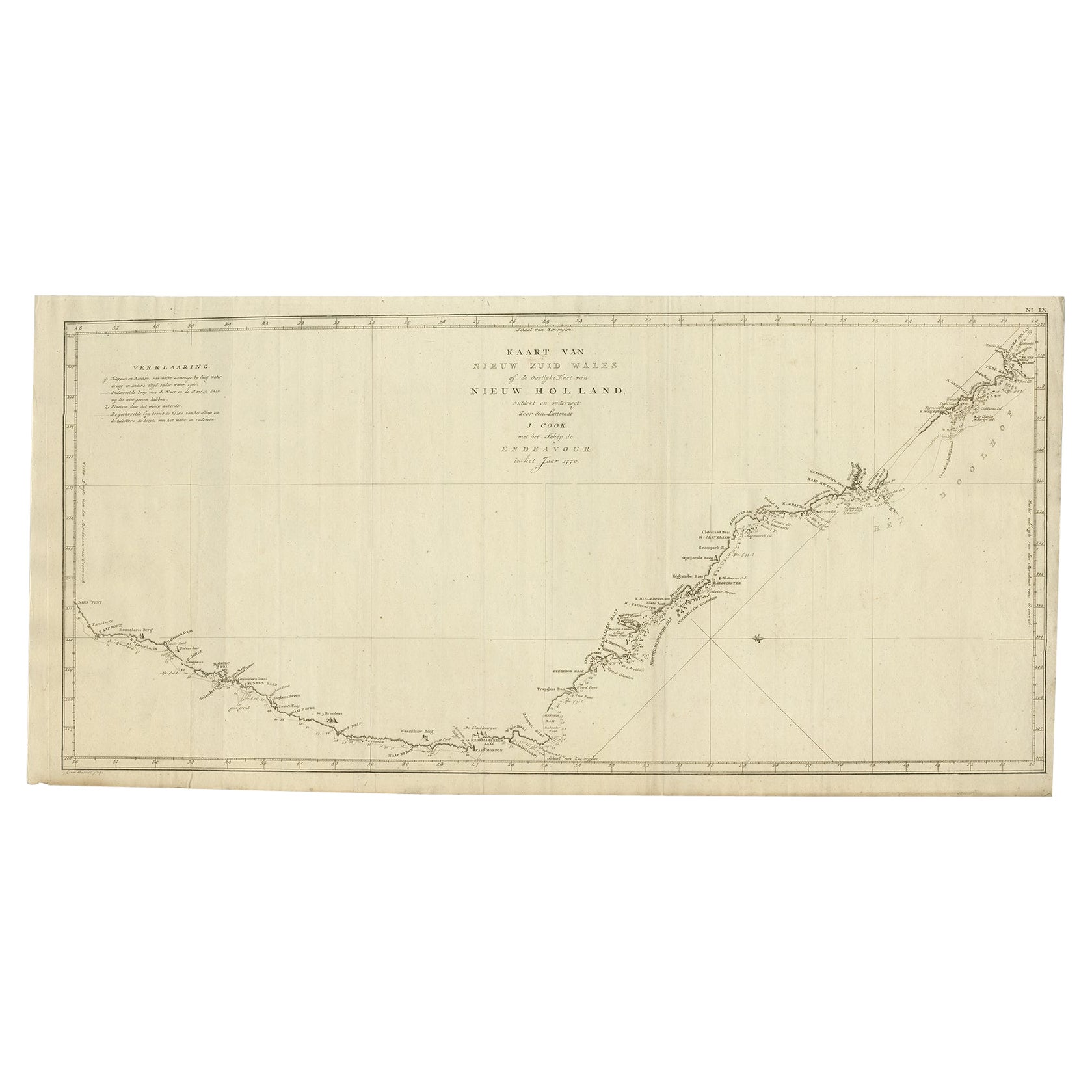
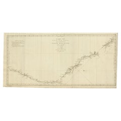
 - Old Map of Cook's Discovery and Charting of the East Coast of Australia, 1803Located in Langweer, NLAntique map titled 'Kaart van Nieuw Zuid Wales of de Oostlyke Kust van Nieuw Holland ontdekt en onderzogt door den Luitenant J. Cook met het Schip de Endeavour in het Jaar 1770'. ...Category
Antique Early 1800s Maps
MaterialsPaper
 $1,527 Sale Price20% Off
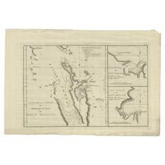
 - Detailed Map of New Zealand Showing the Route of Capt. Cook's First Voyage, 1803Located in Langweer, NLAntique map New Zealand titled 'De Rivier de Theems en Mercurius Baai in Nieuw Zeeland'. Detailed map of New Zealand showing the route of Capta...Category
Antique 19th Century Maps
MaterialsPaper
 $496 Sale Price30% Off
You May Also Like
- Captain Cook's Exploration of Tahiti 18th C. Hand-Colored Map by BellinBy Jacques-Nicolas BellinLocated in Alamo, CAThis beautiful 18th century hand-colored copper plate engraved map is entitled "Carte de l'Isle de Taiti, par le Lieutenant J. Cook" was created by Jacques Nicolas Bellin and publish...Category
Antique Mid-18th Century French Maps
MaterialsPaper
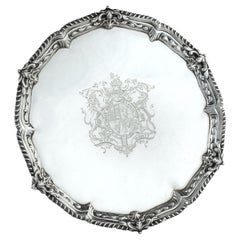
- Presentation silver to the Master Shipwright of Captain Cook’s EndeavourLocated in Lymington, HampshireA George III shaped circular silver salver, plain within a shell and scrolling wave border and outer gadrooned edge, engraved with the royal coat of arms, crest and motto (period 1714-1800) of King George III and, on the reverse with a presentation inscription: For the Launching of His Majestys sloop ‘Otter’ 14 Gunns 305 Tonns 26 October 1767 & His Majestys ship ‘Egmont’ 74 Gunns 1643 Tonns 29 August 1768 by Mr Adam Hayes Master Shipwright of his Majestys yard at Deptford; further monogrammed A*H P A*M. Hallmarked for Benjamin Cartwright, London, 1769 Adam Hayes (1710-1785) began his career as ship’s carpenter in Centurion during Commodore Anson’s famous voyage around the world...Category
Antique 1760s English George III Nautical Objects
MaterialsSilver
- Antique Map of Principality of MonacoBy Antonio Vallardi EditoreLocated in Alessandria, PiemonteST/619 - "Old Geographical Atlas of Italy - Topographic map of ex-Principality of Monaco" - ediz Vallardi - Milano - A somewhat special edition ---Category
Antique Late 19th Century Italian Other Prints
MaterialsPaper
 $226 Sale Price74% Off
 - Original Antique Map of Italy. C.1780Located in St Annes, LancashireGreat map of Italy Copper-plate engraving Published C.1780 Unframed.Category
Antique Early 1800s English Georgian Maps
MaterialsPaper

- Original Antique Map of Asia. C.1780Located in St Annes, LancashireGreat map of Asia Copper-plate engraving Published C.1780 Two small worm holes to right side of map Unframed.Category
Antique Early 1800s English Georgian Maps
MaterialsPaper

- Original Antique Map of India. C.1780Located in St Annes, LancashireGreat map of India Copper-plate engraving Published C.1780 Three small worm holes to right side of map and one bottom left corner Unframed.Category
Antique Early 1800s English Georgian Maps
MaterialsPaper


Recently Viewed
View AllMore Ways To Browse
T Kelly
Southern Pacific
Southern New And Used Furniture
Captains 19th
Antique Cook
Captain Antique
Kelly Go
Pacific Map
Antique Collectors Australia
Pacific Ocean Antique Map
Hand Painted Antique Map
Antique Furniture Depot
17th Century Scottish
Antique Road Maps
Antique Road Map
Antique Map Of Mexico
Antique Maps Of Mexico
Antique Style Atlas