The Great Republic
to
12
215
113
107
72
54
47
39
30
25
22
21
19
19
19
18
18
16
14
14
11
11
11
11
8
8
6
6
6
6
5
5
2
2
2
1
1
3
3
2
1
1
Period: Early 20th Century
Period: 1930s
Period: Mid-19th Century
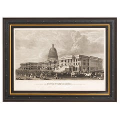
N.E. View of the United States Capitol, Washington, DC Antique Proof Print 1858
Located in Colorado Springs, CO
This engraved print shows a view of the United States Capitol Building, in Washington, D.C. The print depicts the neoclassical building from the northeast orientation, with a bustling street scene in front. The steel engraving is a proof printing, drawn and engraved by Henry Sartain and published in 1858.
Plans began in May 1854 to build a new cast-iron dome for the United States Capitol. The then-architect of the Capitol Thomas Walter and his team were sold on the aesthetics of a new dome, as well as the utility of a fire-proof one. A year later, on March 3, 1855, President Franklin Pierce...
Category
Antique 1850s American Prints
Materials
Paper
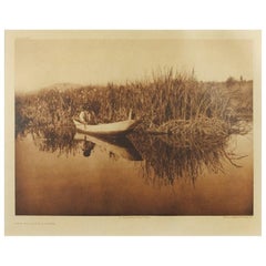
Original Edward S. Curtis Photogravure, "The Klamath Hunter" 1923
By Edward S. Curtis, 1868-1952
Located in Colorado Springs, CO
Presented is a beautiful photogravure showing a Klamath man hunting from a dugout canoe. This image is Plate 458 from Volume 13 of Edward Curtis' epic project The North American Indian. The photogravure was published in 1923 by Suffolk Engr. Co., in Cambridge, MA. The Klamath people are from the inland region of Northern California and Southern Oregon. Their oral history records the volcanic eruption that created Crater Lake over 7000 years ago
Edward S. Curtis created one of the most enduring and iconic visual records in the history of the photographic medium. He was an award-winning artist, a consummate craftsman, a visionary, an intrepid entrepreneur, and was highly regarded as a respected ethnographer and publisher.
Curtis began photographing Native Americans in the mid-1890s and selling these images in his successful downtown Seattle studio. One of his earliest models was Princess Angeline, the aged daughter of chief Sealth, the Suquamish Indian after whom Seattle is named. At the National Photographic Convention of 1899 Curtis was awarded the grand prize for three of his soft-focused, sepia-toned images of Puget Sound Native Americans: Evening on the Sound, The Clam Digger, and The Mussel Gatherer.
Curtis spent the summer of 1900 with George Bird Grinnell observing the Sun Dance at an encampment of Blood, Blackfeet, and Algonquin in Montana. This was a pivotal experience for Curtis, confirming his desire to study and photograph the Native tribes of North America. A trip to visit the Hopi reservation in Arizona a few months later further fueled his enthusiasm.
Curtis envisioned a plan to create a massive scholarly and artistic work that would document the tribes west of the Mississippi, their ceremonies, beliefs, daily life, and landscapes. In 1906, Curtis approached railroad tycoon J.P. Morgan to request financial assistance for his project. Morgan agreed to pay him a total of $75,000, or $15,000 a year for five years. Morgan and Curtis decided that Curtis' masterwork, The North American Indian, would be a set of 20 volumes of ethnographic text illustrated with high quality photoengravings taken from his glass plate negatives. Each of these volumes would be accompanied by a portfolio of large size images, all sumptuously bound in Moroccan leather. The papers used for printing would also be of the best quality: a Dutch etching stock by Van Gelder, a Japanese vellum, and for the most discerning subscribers, a translucent Japanese tissue paper. To fund publication, Curtis would sell subscriptions at approximately $3,000 per set, with a total of 500 sets to be published.
An ambitious and extensive project, Curtis spent much of his life documenting as many Native tribes as possible. The importance and the urgency of the task was clear to him, as he wrote in the introduction to his first volume of The North American Indians in 1907, "The information that is to be gathered ... respecting the mode of life of one of the great races of mankind, must be collected at once or the opportunity will be lost." In 1930, some 24 years after his initial request for funding, the last two volumes, Vol. 19 and Vol. 20, were published and The North American Indian project was finally completed. Curtis took over 40,000 photographs and made over 10,000 wax cylinder...
Category
Vintage 1920s American Photography
Materials
Paper
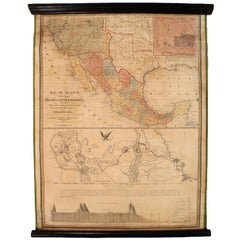
1847 Antique Map of Mexico, Texas and California by Samuel Augustus Mitchell
By Samuel Augustus Mitchell 1
Located in Colorado Springs, CO
Presented is the second edition of Samuel Augustus Mitchell's Map of Mexico, Including Yucatan & Upper California, an important map showing the progress of the Mexican-American War. ...
Category
Antique 1840s American Maps
Materials
Paper
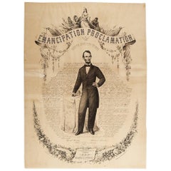
1865 Emancipation Proclamation, Antique Lithograph by P.S. Duval and Son
Located in Colorado Springs, CO
Presented is a lithographic broadside of the text of the Emancipation Proclamation issued on January 1, 1863. This broadside was published in...
Category
Antique 1860s American Historical Memorabilia
Materials
Paper
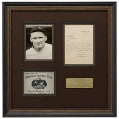
Walter Johnson, Washington Senators Hall of Fame Pitcher, Signed Letter, 1925
Located in Colorado Springs, CO
Offered is a collage featuring a typed letter signed by baseball’s Walter Johnson, a reproduction scorecard from the 1924 World Series, and a photo of Johnson in his uniform. All elements are framed and matted together in a custom-built frame.
The letter is dated November 7, 1925 and addressed to a Mr. Leo Bicher. In his letter, he explains how he missed the letter at first and will send a signed baseball to Bicher if there is another exposition in the future. At the bottom, Johnson signed his name in dark ink. The score card celebrates the Washington Base Ball Club as the 1924 World Series pennant winners. The Washington Senators...
Category
Vintage 1920s American Sports Equipment and Memorabilia
Materials
Paper
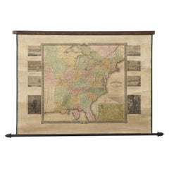
"The United States from the Latest Authorities" Antique Wall Map, 1835
Located in Colorado Springs, CO
This is a 1835 map of “The United States from the Latest Authorities” by Ezra Strong. A hand-colored engraved wall map of the eastern half of the United States, this map has a large inset of the "Oregon District" and several engraved city views and two portraits.
The primary map extends to Mexico Texas and the Missouri Territory, showing the course of the Missouri River to Ft. Mandan and Old Ft. Mandan, and noting many forts along the river. The territories to the east of Missouri Territory are separately delineated as Sioux District and Huron District. The western details of the map are very good for a map of this time period, with many Native American settlements, villages, forts and other details noted.
The map is bordered with vignettes of Boston, New York, Philadelphia, Hartford, Cincinnati, and Baltimore. Each vignette notes the date settled, primary settler, and the population as of 1830. Two portraits of LaFayette and George Washington are presented in full length with related biographical information.
A large inset map at lower right shows the Oregon District, centered on the Columbia River and extending to the Rocky Mountains. This is one of the earliest commercial appearances of a separate map of Oregon...
Category
Antique 1830s American Maps
Materials
Paper
"Join the Air Service" Vintage WWI Poster by J. Paul Verrees, 1917
Located in Colorado Springs, CO
This is very scarce WWI recruiting poster for the Army Air Service. The poster dramatically features a two-man open cockpit biplane with American and French markings flying against a red sky background. In the foreground, two uniformed spotters look on. The poster reads "Join the Air Service...
Category
Vintage 1910s American Posters
Materials
Paper
Army Air Service "Over There!" WW I Recruitment Poster by Louis Fancher, 1918
Located in Colorado Springs, CO
Offered is a 1918 WWI recruitment poster by Louis Fancher. This U.S. Army Signal Corps Recruitment Poster features an army serviceman raising one hand and...
Category
Vintage 1910s American Posters
Materials
Paper
1847 Ornamental Map of the United States & Mexico by H. Phelps
Located in Colorado Springs, CO
Offered is an original 1847 ornamental map of the U.S. entitled "Ornamental Map of the United States & Mexico" by Humphrey Phelps. The map was issued as an act of Congress by Phelps on Fulton Street, New York. The broadside is elaborately hand-colored.
This is a very detailed and graphic propaganda map of the United States expressing U.S. dominance of the North American continent. The hand-colored map proclaims the Manifest Destiny, with the recent acquisition of Upper California and Texas at the conclusion of the Mexican-American War. The newly acquired land is boldly colored, standing in stark contrast to the rest of the U.S. The map details a potential route for a railroad running from New York City, to Buffalo, to Chicago, then west along the Oregon Trail to Oregon City. This route anticipates the construction of the transcontinental railroad by nearly 20 years.
The map includes elaborately detailed renderings of George Washington, Hernan Cortez, and Montezuma at top to represent European expansion to the Americas. At bottom are four inset designs with text showing the following: a chronological history of the U.S. beginning from settlement to the U.S. victory in the Mexican-American war; an illustration of General Zachary Taylor with details on the Oregon Territory; an illustration of the Aztec Temple of the Sun in Tenochtitlan and a chronology of the Conquest of the Aztec Empire under Cortez; a portrait of General Antonio Lopez de Santa Anna...
Category
Antique 1840s American Maps
Materials
Paper
Antique Map of Paris, "Carte Routiere des Environs de Paris" 1841
Located in Colorado Springs, CO
This beautiful hand-colored road map of Paris was published in 1841. The map shows Paris and the surrounding area in a folding pocket map. Organized and detailed for travelers, this ...
Category
Antique 1840s French Maps
Materials
Paper
1855 "New-York City & County Map" by Charles Magnus
By Charles Magnus
Located in Colorado Springs, CO
This is a beautiful hand-colored map titled “New York City & County Map with Vicinity entire Brooklyn, Williamsburgh, Jersey City &c.” The work was published in 1855 by Charles Magnu...
Category
Antique 1850s American Maps
Materials
Paper
U.S. Navy League, "War Clouds Gather!" by Hazel Roberts, Vintage Poster, 1916
Located in Colorado Springs, CO
This propaganda poster was designed by Hazel Roberts (1883-1966) to encourage onlookers to join the U.S. Navy League. The poster was issued in 1916 and features a depiction of a Navy soldier facing the horizon and playing a bugle. The text at bottom reads "War Clouds Gather! Manhood willing but unarmed. Help the Navy-Join the Navy League/ Local Headquarters." The artist's signature from the lithograph...
Category
Vintage 1910s American Historical Memorabilia
Materials
Paper
"Taylor and His Generals, " First Edition, Published by E. H. Butler & Co., 1847
Located in Colorado Springs, CO
Taylor and his Generals. New York: E.H. Butler & Co., 1847. First Edition. Rebound in quarter leather and marble paper boards. Housed in custom slipcase.
Presented is the 1847 First Edition of Taylor and His Generals. Published by E.H. Butler & Company, the book has numerous portraits and engravings throughout. It has been beautifully rebound in quarter leather and marble paper boards. The spine has gilt embossed decoration stating that it’s a first edition. The book is housed in a custom-built archival slipcase with a photo of Taylor on the front.
Written and published before Taylor ran for the Presidency, this book would have been a powerful propaganda tool for the soon-to-be 12th President of the United States. The full title page describes the work as “Taylor and His Generals; A Biography of Major-General Zachary Taylor; And Sketches of the Lives of Generals Worth, Wool, and Twiggs with a full account of the Actions of their Various Divisions in Mexico Up to the Present Time; Together with a Sketch of the Major-General Winfield Scott and an Account of his Divisions in Mexico.”
Taylor fought and commanded troops in the War of 1812, Black Hawk War, and the Second of the Seminole Wars before playing a major role in the victory of the Mexican-American War. The book takes the reader through the early life of Taylor and his military career with a particular focus on his surprising victory at the Battle of Buena Vista. Generals Worth, Wool, and Twiggs that served under Taylor and Major-General Scott each get a chapter dedicated to their own history and military careers
The Battle of Buena Vista took place in February of 1847 during the Mexican-American War. With only about 5,000 soldiers, Taylor repelled General Antonio Lopez de Santa Anna...
Category
Antique 1840s American Books
Materials
Paper
1908 Artillery & Musician Infantry Uniforms by Ogden, Antique Chromolithograph
Located in Colorado Springs, CO
This colorful lithograph by H. A. Ogden was published in 1908 by Brigadier General J. B. Allshire. Originally published as a comprehensive series of U. S. military uniforms, this pri...
Category
Antique Early 1900s American Historical Memorabilia
Materials
Paper
U.S. Navy WWI Poster "We Clear the Way for Your Fighting Dollars, " 1918
Located in Colorado Springs, CO
This WWI poster features a US sailor after disembarking from a ship and ready for battle. In the background are powerful warships setting the scene. Below th...
Category
Vintage 1910s American Historical Memorabilia
Materials
Paper
Lindbergh His Story in Pictures by Francis Miller, Signed Limited Copy 70 of 250
Located in Colorado Springs, CO
Miller, Francis Trevelyan (Charles A Lindbergh). Lindbergh: His Story in Pictures. New York and London: G.P. Putnam's Sons (Knickerbocker Press), 1929. Collector's Edition. Octavo, o...
Category
Vintage 1920s Books
Materials
Paper
"Lady Washington's Reception, " Engraved by A. H. Ritchie, Antique Print, 1865
Located in Colorado Springs, CO
This 1865, hand-colored engraving by A. H. Ritchie is entitled Lady Washington's Reception and is based on Daniel F. Huntington's original painting "Th...
Category
Antique 1860s American Prints
Materials
Paper
Antique Horse Print "The Stone Faceder" Signed by Snaffles, 1934
Located in Colorado Springs, CO
This is a hand-colored, remarked and signed Charles Johnson Payne lithographic print, entitle: The Stone Faceder. The border area of the art is sign by the artist using his known pseudonym - Snaffles. The print depicts equestrian style riding in the Irish countryside. The art also features a hand-drawn fox running through brush leading one to believe this is an Irish fox hunting print.
Born January 17, 1884 at Leamington Spa, Warwickshire, Charlie was the fourth of a boot-maker’s eight children and from his youth developed a passion for all things military. He tried to enlist in the army to fight in the Boer war, but was rejected on the grounds that he was too young. Eventually, he joined the Royal Garrison Artillery at the age of 18 as a gunner...
Category
Vintage 1930s British Prints
Materials
Paper
"The Bicester & Warden Hill" by Frank Stewart, Vintage Signed Print, 1935
By Frank Algernon Stewart
Located in Colorado Springs, CO
Presented is an original fox hunting print signed by the artist, Frank Algernon Stewart (1877-1945). This print depicts one of England’s most famous fox hunting events, the Bicester and Warden Hill Hunt. The scene depicts six men on horseback galloping across a field in mid-hunt. All coloring is still intact, with lush green fields and bright riders’ jackets. As evidenced here, Stewart’s renderings of horseback hunts are some of the most celebrated and collected in the world.
The beginnings of the Bicester Hunt started around the 1790s when John Warde Esq. bought a set of hounds and hunted in the Bicester area, with the main kennels located at Bainton. He hunted for 18 seasons. The first master of the Bicester Hunt was Sir Thomas Mostyn...
Category
Vintage 1930s English Prints
Materials
Paper
1864 Map of North America, Antique Hand-Colored Map, by Adolphe Hippolyte Dufour
Located in Colorado Springs, CO
Offered is a map of North America entitled Amerique du Nord from 1864. This rare, separately published wall map was produced by Adolphe Hippolyte Dufour. This map includes vibrant an...
Category
Antique 1860s French Maps
Materials
Paper
