Items Similar to Early 19th Century Hand Colored Map of the United States and Caribbean Islands


Want more images or videos?
Request additional images or videos from the seller
1 of 6
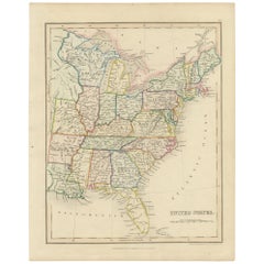
Early 19th Century Hand Colored Map of the United States and Caribbean Islands
About the Item
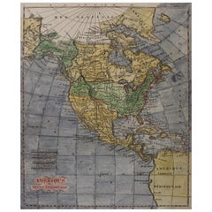
Hand coloured early 19th century map by Giraldon of France titled "Etats Unis et Grandes Antilles" (United States and Greater Antilles).
- Creator:Giraldon (Maker)
- Dimensions:Height: 13.5 in (34.29 cm)Width: 10 in (25.4 cm)Depth: 0.975 in (2.48 cm)
- Materials and Techniques:
- Place of Origin:
- Period:
- Date of Manufacture:circa 1810
- Condition:Wear consistent with age and use. Foxing to paper.
- Seller Location:Hamilton, CA
- Reference Number:1stDibs: LU1355214145611
About the Seller
5.0
Platinum Seller
These expertly vetted sellers are 1stDibs' most experienced sellers and are rated highest by our customers.
Established in 2010
1stDibs seller since 2015
1,218 sales on 1stDibs
Typical response time: <1 hour
- ShippingRetrieving quote...Ships From: Hamilton, Canada
- Return PolicyA return for this item may be initiated within 3 days of delivery.
More From This SellerView All
- Early 19th Century Hand Coloured Map of North America by Aaron ArrowsmithBy Aaron ArrowsmithLocated in Hamilton, OntarioHand coloured map in French by English cartographer Aaron Arrowsmith (1750–1823) titled "Amerique Septentionale" (North America). Map size: 9.5" x 8" Mat size: 20.5" x 14.25".Category
Antique Early 19th Century English Maps
MaterialsPaper
- Vintage United States Post Office Department Enamel Advertising SignLocated in Hamilton, OntarioThis vintage metal sign has no maker's marks, but presumed to have originated from the United States and dates to approximately 1976 and done in a traditional American Colonial style...Category
Mid-20th Century American American Colonial Historical Memorabilia
MaterialsBrass, Cut Steel
- 18th Century Map of the Southern Balkans by Giovanni Maria CassiniBy Giovanni Maria CassiniLocated in Hamilton, Ontario18th century map by Italian engraver Giovanni Maria Cassini (Italy 1745-1824). Map of the Southern Balkans: Rome. Hand colored and copper engraved print done in the year 1788. It in...Category
Antique 18th Century Italian Maps
MaterialsPaper
- Negretti and Zambra Aneroid Barometer, 19th CenturyLocated in Hamilton, Ontario19th century Negretti & Zambra aneroid barometer. Large English oak, Gothic style barometer. Free shipping within the United States and Canada.Category
Antique 19th Century Great Britain (UK) Gothic Scientific Instruments
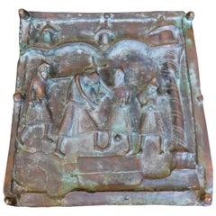
- 19th Century Italian Bronze Church Door Panel "Stations of the Cross" OrtiseiLocated in Hamilton, OntarioThis 19th century Italian bronze panel is a section from a church door in Italy. This religious icon is a depiction of the "Stations of the Cross". It was produced from the now defun...Category
Antique 19th Century Italian Classical Roman Wall-mounted Sculptures
MaterialsBronze
- Map of the Kingdom of Sardinia and Part of the Kingdom of Genoa, RomeBy Giovanni Maria CassiniLocated in Hamilton, Ontario18th century map by Italian engraver Giovanni Maria Cassini (Italy 1745-1824). Map of Part of the Kingdom of Sardinia and Part of the Kingdom of Genoa: Rome. This is a hand colored a...Category
Antique 18th Century Italian Maps
MaterialsPaper


You May Also Like
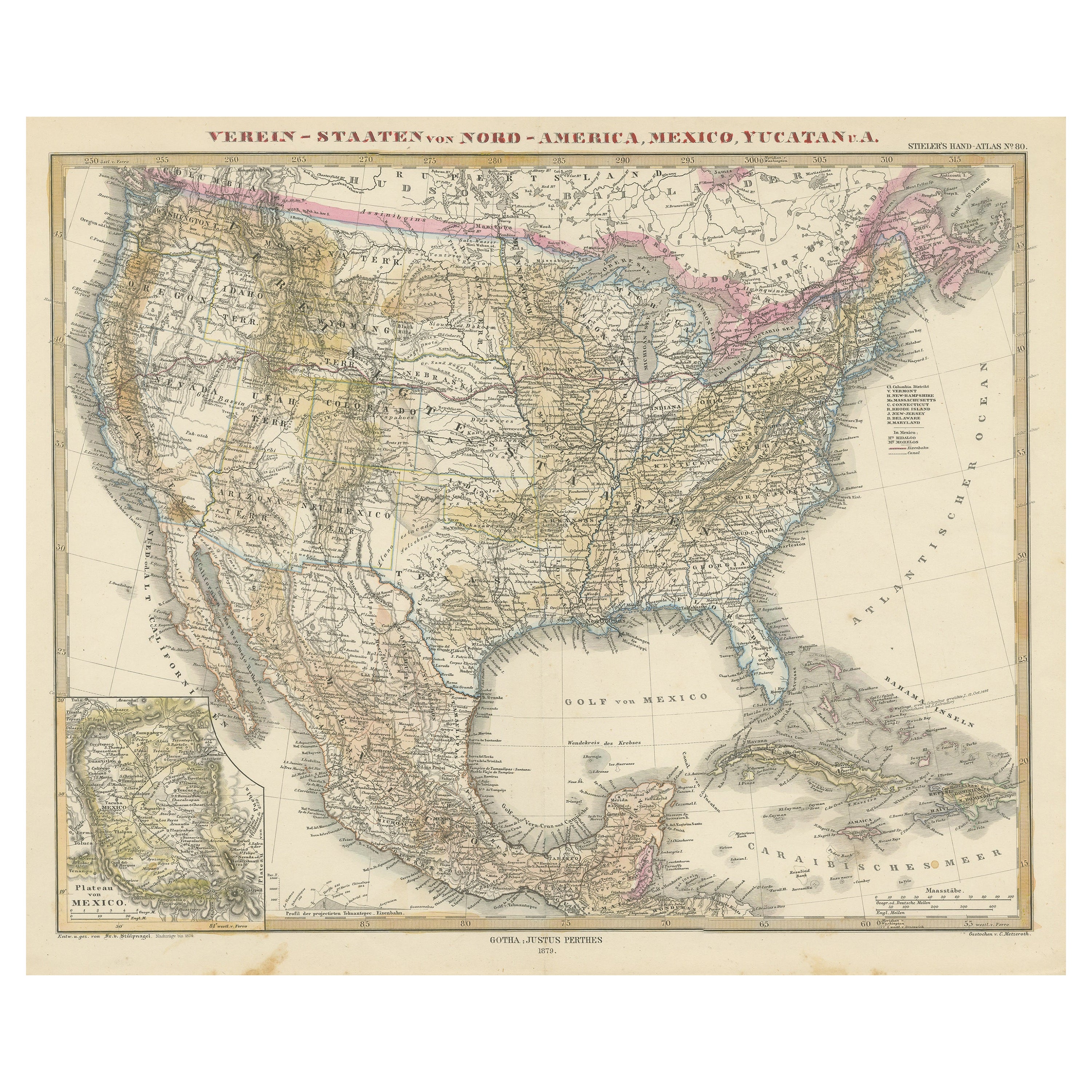
- Antique Map with Hand Coloring of the United States and the CaribbeanLocated in Langweer, NLAntique map titled 'Verein-Staaten von Nord-America, Mexico, Yucatan u.a.'. Very detailed map of the United States of America showing the Caribbean. With an inset map of the surround...Category
Antique Late 19th Century Maps
MaterialsPaper
- Framed 1839 Hand Colored Map of the United StatesLocated in Stamford, CTFramed hand colored map of the United States of America from 1839. Newly framed in a giltwood frame.Category
Antique 1830s American American Classical Maps
MaterialsGiltwood, Paper, Glass
- Framed 1820s Hand Colored Map of the United StatesLocated in Stamford, CTFramed 1820s hand colored map photos of North America and South America. As found framed in giltwood frame.Category
Antique 1820s American Spanish Colonial Maps
MaterialsGiltwood, Paper, Glass
- Antique Map of the United States of America, also showing the CaribbeanLocated in Langweer, NLAntique map titled 'Verein-Staaten von Nord-America, Mexico, Yucatan u.a.'. Very detailed map of the United States of America showing the ...Category
Antique Mid-19th Century Maps
MaterialsPaper
- Original Antique Hand-colored Map of the United States, circa 1845Located in Langweer, NLAntique map titled 'United States'. Old map of the United States, includes the last part of the North West Territory (present day Wisconsin and part of Minnesota). It also marks Ft. Crawford at the confluence of the Mississippi River and the Ouisconsin River (present day Wisconsin River). Published by Orr & Company; Amen Corner...Category
Antique Mid-19th Century Maps
MaterialsPaper
- Small Map of the United StatesLocated in Langweer, NLAntique map titled 'Amérique septe. Physique'. Small map of the United States. lithographed by C. Callewaert brothers in Brussels circa 1870.Category
Antique Mid-19th Century Maps
MaterialsPaper


Recently Viewed
View AllMore Ways To Browse
Antique Furniture United States
United States Map
Map Of United States
The United States Map
Map Of The United States
Islands Of Caribbean
Hand Colored Map
Antique United States Maps
Antique Map United States
Antique United States Map
United States Map Antique
Antique Maps Of United States
Antique Map Of The United States
Antique Maps Of The United States
Antique Caribbean
Antique Caribbean Furniture
19th Caribbean
Antique Island Caribbean