Wildness An Ode to Newfoundland and Labrador
View Similar Items

Wildness An Ode to Newfoundland and Labrador
About the Item
- Dimensions:Height: 2 in (5.08 cm)Width: 9.88 in (25.1 cm)Length: 2 in (5.08 cm)
- Materials and Techniques:
- Place of Origin:
- Period:
- Date of Manufacture:2019
- Production Type:New & Custom(Current Production)
- Estimated Production Time:Available Now
- Condition:
- Seller Location:New York, NY
- Reference Number:Seller: 97807148782321stDibs: LU1878317200631

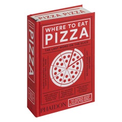
Phaidon
More From This Seller
View All2010s Italian Books
Paper
21st Century and Contemporary Books
Paper
2010s Chinese Books
Paper
21st Century and Contemporary European Books
Paper
2010s American Books
Paper
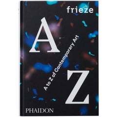
The ultimate guide to 25 years of contemporary art, as seen through the filter of the world's leading contemporary art magazine
frieze A to Z of Contemporary Art charts the dynamic, changing landscape of the contemporary art and culture of the past quarter century. Drawing on frieze magazine’s exceptional back catalogue of articles, this book brings together a curated collection of over fifty engaging highlights. It features artist interviews; essays on subjects as varied as museums, photography, pre-historic art and television; and think pieces on broader cultural topics, such as fame, gentrification, nostalgia, and style. The book's content - selected from throughout the magazine's history - offers a guide to this dynamic era of visual culture, revealing the increasing internationalism, popularity, and market dominance of contemporary art.
frieze magazine was set up in 1991 and is the leading magazine of contemporary art and culture. frieze includes essays, reviews, and columns by today's most forward-thinking writers, artists, and curators.
Published to coincide with the 25th anniversary of frieze, the world's foremost magazine focusing on contemporary art and culture Presents the most prescient and stimulating articles from the extensive frieze archive in one neat, stylishly designed and fully illustrated package, creating an accessible and insightful guide to contemporary art Organized alphabetically by topic, from Avant-garde to Zeitgest, it can be enjoyed cover-to-cover from A to Z or dipped into New texts by frieze editors Dan Fox, Jorg Heiser, and Jennifer Higgie, look back at the magazine's history and reflect on how the cultural landscape has changed The book brings together two trusted brands in international art publishing...21st Century and Contemporary Books
Paper
You May Also Like
Antique 1740s Maps
Paper
Antique 19th Century Maps
Paper

Antique Mid-19th Century English Other Books
Paper
Antique 1850s Maps
Paper
Antique 1820s Maps
Paper
Antique 1820s Maps
Paper