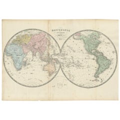
Antique Map of the World by A. Vuillemin, 1854
View Similar Items


Want more images or videos?
Request additional images or videos from the seller
1 of 2
Antique Map of the World by A. Vuillemin, 1854
About the Item
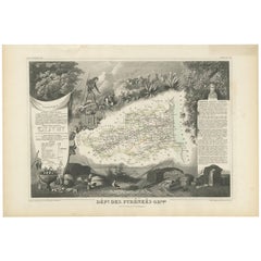
- Creator:Victor Levasseur (Artist)
- Dimensions:Height: 20.48 in (52 cm)Width: 29.53 in (75 cm)Depth: 0.02 in (0.5 mm)
- Period:
- Date of Manufacture:1854
- Condition:General age-related toning. Some marginal tears. Please study image carefully.
- Seller Location:Langweer, NL
- Reference Number:Seller: BG-05614/11stDibs: LU3054310738923
About the Seller
5.0
Platinum Seller
These expertly vetted sellers are 1stDibs' most experienced sellers and are rated highest by our customers.
Established in 2009
1stDibs seller since 2017
1,916 sales on 1stDibs
More From This SellerView All
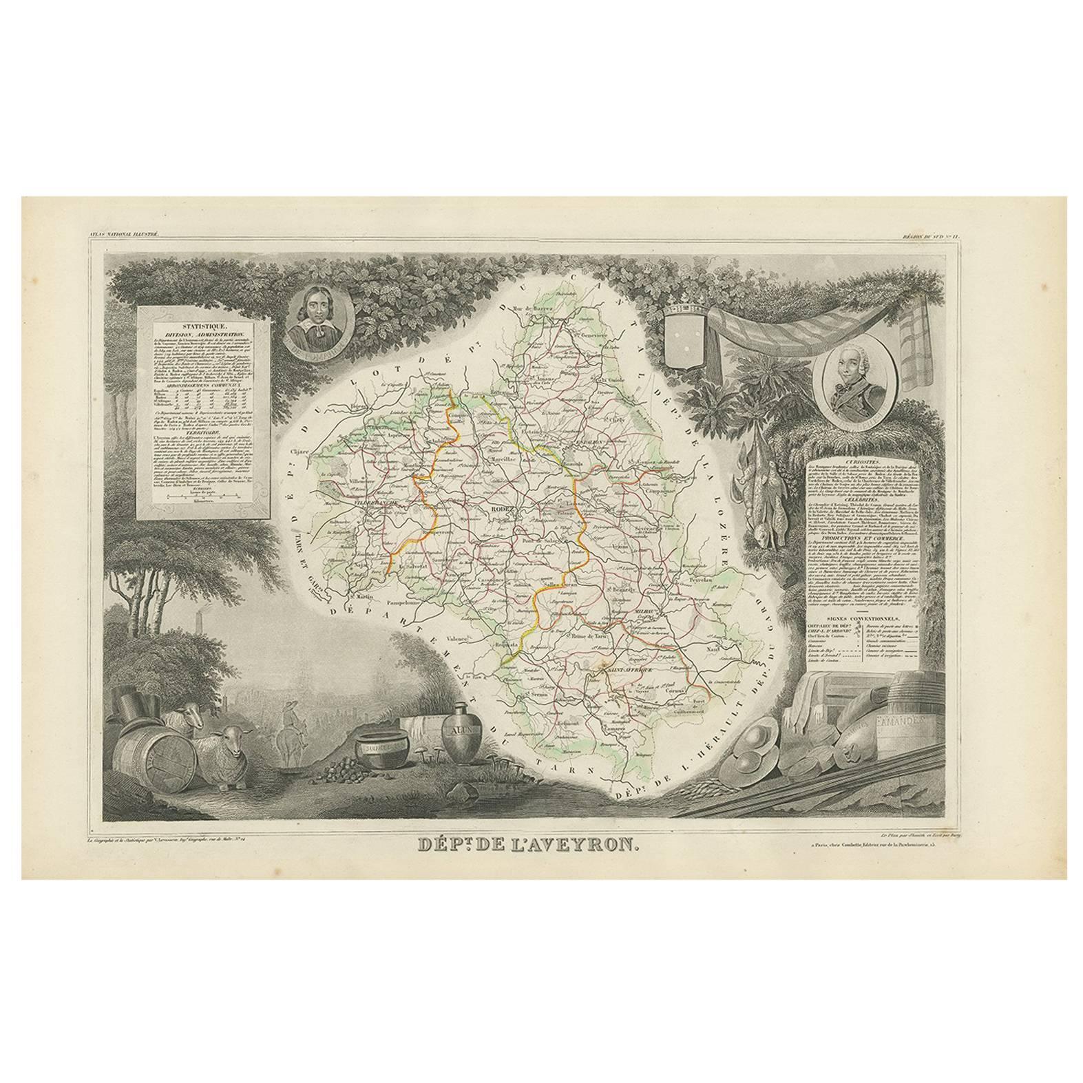
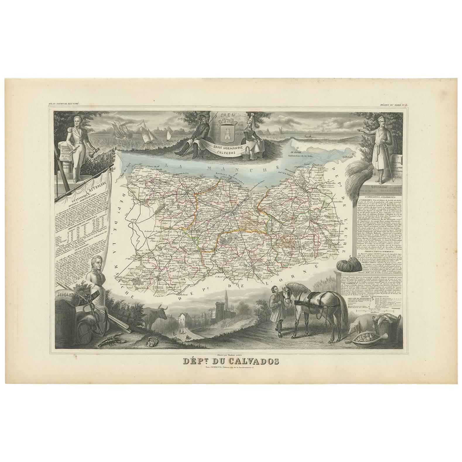
- Antique Map of the World by A. Vuillemin, 1854By Victor LevasseurLocated in Langweer, NLThis map originates from ‘Atlas National de la France Illustré’. Published by A. Combette, Paris, 1854.Category
Antique Mid-19th Century Maps
MaterialsPaper
 $307 Sale Price25% Off
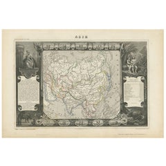
 - Antique Map of Asia by V. Levasseur, 1854By Victor LevasseurLocated in Langweer, NLAntique map titled 'Asie'. Map of the main Asian continent. The decorated border shows various images, as well as two blocks of statistical text on the continent, including populatio...Category
Antique Mid-19th Century Maps
MaterialsPaper
 $218 Sale Price27% Off
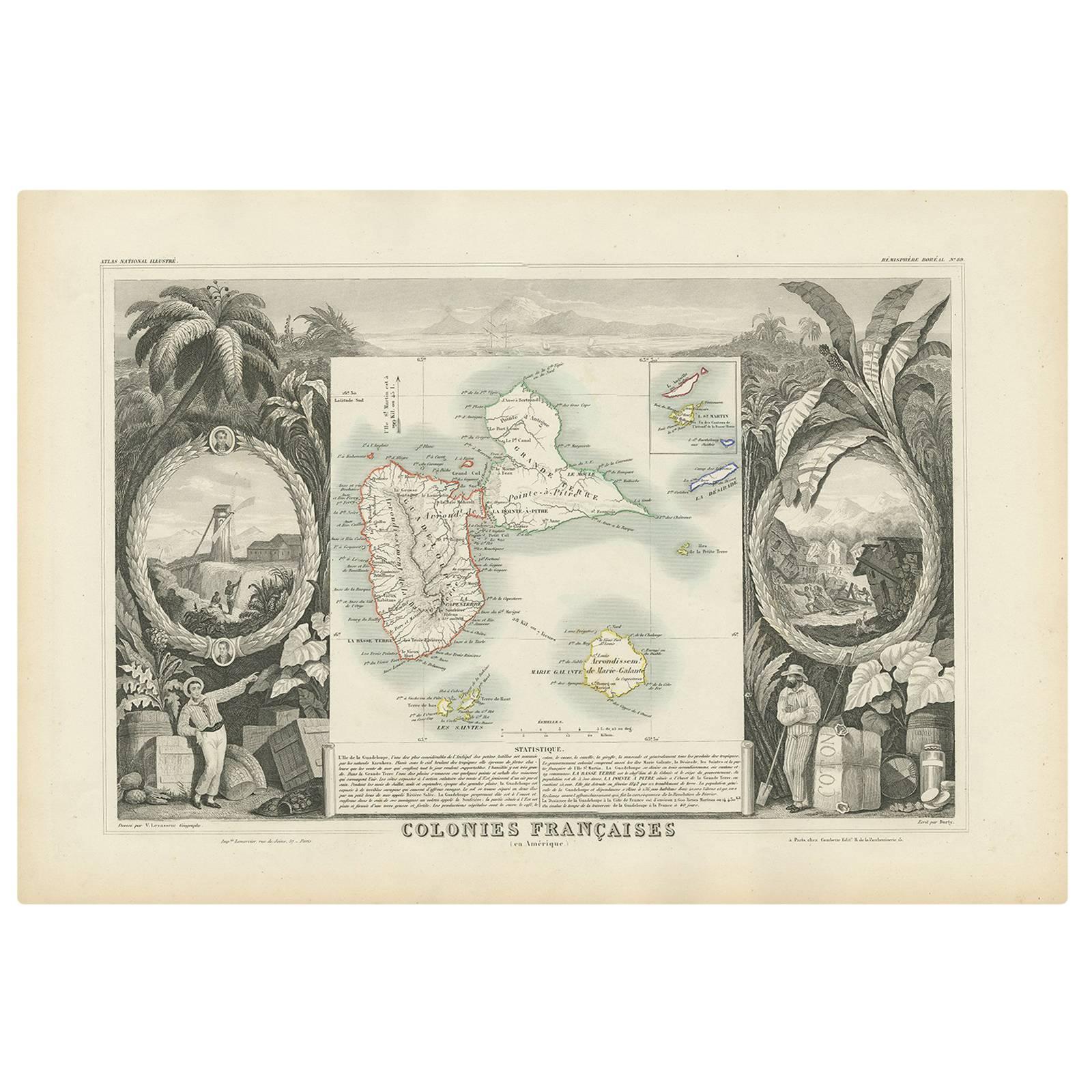
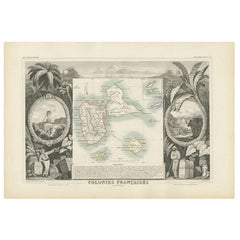
 - Antique Map of the French Colony Guadeloupe by V. Levasseur, 1854By Victor LevasseurLocated in Langweer, NLAntique map titled 'Colonies Françaises (en Amerique). Detailed map of the island of Guadeloupe in the Caribbean Sea, with decorative frame containing views of the island. This map o...Category
Antique Mid-19th Century Maps
MaterialsPaper
 $164 Sale Price25% Off
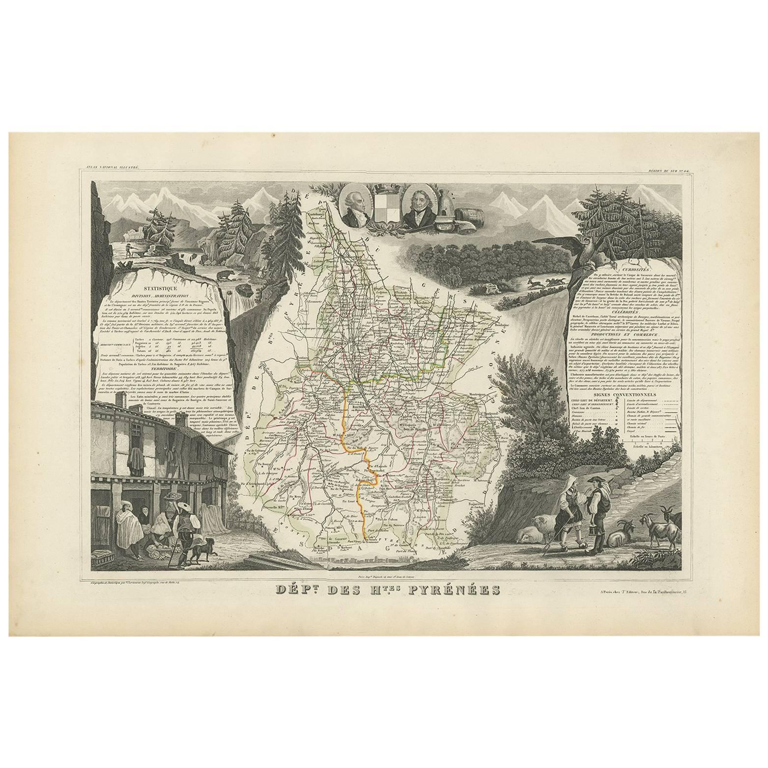
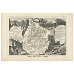
 - Antique Map of the Hautes Pyrenees 'France' by V. Levasseur, 1854By Victor LevasseurLocated in Langweer, NLAntique map titled 'Dépt. des Htes. Pyrénées'. Map of the French department of Hautes Pyrenees, France. This area is home to the wine producing region, Madiran. Madrian is best known...Category
Antique Mid-19th Century Maps
MaterialsPaper
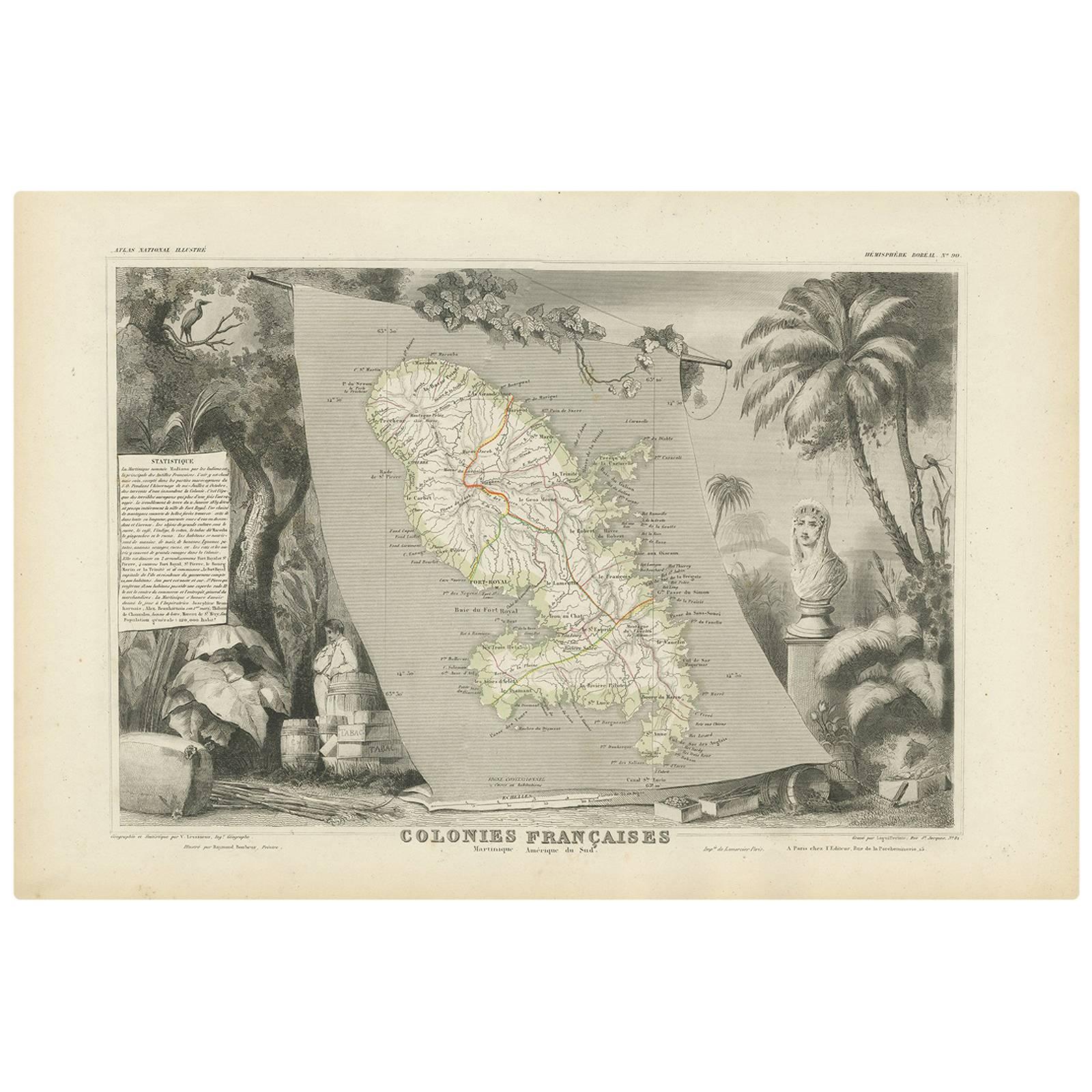
- Antique Map of the French Colony Martinique by V. Levasseur, 1854By Victor LevasseurLocated in Langweer, NLAntique map titled 'Colonies Françaises. Martinique, Amérique du Sud'. This map originates from ‘Atlas National de la France Illustré’. Published by A. Combette, Paris, 1854.Category
Antique Mid-19th Century Maps
MaterialsPaper
 $164 Sale Price25% Off
 - Antique Map of the Pyrenees Orientales 'France' by V. Levasseur, 1854By Victor LevasseurLocated in Langweer, NLAntique map titled 'Dépt. des Pyréneés Orles'. Map of the French department of Pyrenees Orientales, France. This area is a well-known wine producing region. A wide variety of wines c...Category
Antique Mid-19th Century Maps
MaterialsPaper
You May Also Like
- Plan of Paris, France, by A. Vuillemin, Antique Map, 1845Located in Colorado Springs, COThis large and detailed plan of Paris was published by Alexandre Vuillemin in 1845. The map conveys a wonderful amount of information and is decorated throughout with pictorial vigne...Category
Antique 1840s American Maps
MaterialsPaper
- Original Antique Map of The World by Thomas Clerk, 1817Located in St Annes, LancashireGreat map of The Eastern and Western Hemispheres On 2 sheets Copper-plate engraving Drawn and engraved by Thomas Clerk, Edinburgh. Published by Mackenzie And Dent, 1817 ...Category
Antique 1810s English Maps
MaterialsPaper
- Map, Exploring The WorldLocated in New York City, NY300 stunning maps from all periods and from all around the world, exploring and revealing what maps tell us about history and ourselves. Selected by an international panel of cartographers, academics, map dealers and collectors, the maps represent over 5,000 years of cartographic innovation drawing on a range of cultures and traditions. Comprehensive in scope, this book features all types of map from navigation and surveys to astronomical maps, satellite and digital maps, as well as works of art inspired by cartography. Unique curated sequence presents maps in thought-provoking juxtapositions for lively, stimulating reading. Features some of the most influential mapmakers and institutions in history, including Gerardus Mercator, Abraham Ortelius, Phyllis Pearson, Heinrich Berann...Category
21st Century and Contemporary Hong Kong Books
MaterialsPaper
 $60 / item
 - Large Original Antique Map of The World, Fullarton, C.1870Located in St Annes, LancashireGreat map of the World. Showing both hemispheres From the celebrated Royal Illustrated Atlas Lithograph. Original color. Published by Fullarton, Edinburgh, C.1870 Unframed. Rep...Category
Antique 1870s Scottish Maps
MaterialsPaper
- Colored wall map of the WORLDBy ChambonLocated in ZWIJNDRECHT, NL“Mappe Monde, contenant les Parties Connues du Globe Terrestre” CHAMBON, Gobert-Denis (France, 17.. - 1781) Paris, Longchamps et Janvier, 1754 Size H. 115 x W. 145 cm. Gobert-Denis Chambon made copper engraving after the work of Guillaume De L’Isle, published in 1754 by Jean Janvier and S.G. Longschamps. A huge wall map of the world in two hemispheres printed on two sheets, depicting the Eastern and Western hemispheres supported by two male figures, decorated at the bottom right and left with two celestial hemispheres (boreal and southern) and at the bottom in the middle with an armillary sphere, in addition. This map is most notable for its depiction of the Sea of Japan labeled "Mer de Corée" and of "Mer de L'Ouest" or Sea of the West - a great sea, easily the size of the Mediterranean, to flow from the then-known Strait of Juan de Fuca...Category
Antique Mid-18th Century French French Provincial Maps
MaterialsWood, Paper

- 1854 Map of Massachusetts, Connecticut and Rhode Island, Antique Wall MapLocated in Colorado Springs, COThis striking wall map was published in 1854 by Ensign, Bridgman & Fanning and has both full original hand-coloring and original hardware. This impression is both informative and highly decorative. The states are divided into counties, outlined in red, green, and black, and subdivided into towns. Roads, canals, and railroad lines are prominently depicted, although they are not all labeled. The mapmakers also marked lighthouses, banks, churches, and prominent buildings, with a key at right. The map is an informative and comprehensive overview of the infrastructural development of New England prior to the Civil War. Physical geographies depicted include elevation, conveyed with hachure marks, rivers and lakes. The impression features an inset map of Boston...Category
Antique 19th Century American Maps
MaterialsPaper


