Items Similar to Batavia 1733 - Hand-Colored Antique Harbor Map of Nowadays Jakarta in Indonesia

Want more images or videos?
Request additional images or videos from the seller
Batavia 1733 - Hand-Colored Antique Harbor Map of Nowadays Jakarta in Indonesia
About the Item
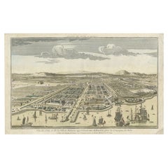
A historical print depicting the city of Batavia (present-day Jakarta during the Dutch colonial period). The view is from the sea, looking towards the city. The skyline is dominated by European-style buildings, indicative of colonial architecture, with a mountain range in the background. In the foreground, various sailing ships, representative of the 17th-century naval technology, dominate the harbor. Some are anchored, while others are under sail, with a few small boats scattered between them. The sea is rendered with careful lines to suggest waves, and the sky is filled with clouds, possibly suggesting a bustling port city with a dynamic maritime culture.
The text "Guiseppe Filosi Sculp. Vin." indicates the artist who engraved the print (Guiseppe Filosi) and may suggest a place associated with the artist or the creation of the print (possibly Venice, abbreviated as "Vin."). The presence of such text usually indicates the printmaker’s signature and is common in historical prints.
More research needed. Possibly published by Tirion on the early 18th century.
- Dimensions:Height: 7.09 in (18 cm)Width: 12.21 in (31 cm)Depth: 0 in (0.02 mm)
- Materials and Techniques:Paper,Engraved
- Period:1730-1739
- Date of Manufacture:1733
- Condition:Good. There are visible central vertical folds, which is common in old maps that were originally bound in books. Later hand-coloring. Tight margin on the top, but image is intact. Ideal for framing.
- Seller Location:Langweer, NL
- Reference Number:Seller: BG-13454-61stDibs: LU3054337747602
About the Seller
5.0
Platinum Seller
These expertly vetted sellers are 1stDibs' most experienced sellers and are rated highest by our customers.
Established in 2009
1stDibs seller since 2017
1,956 sales on 1stDibs
Typical response time: <1 hour
- ShippingRetrieving quote...Ships From: Langweer, Netherlands
- Return PolicyA return for this item may be initiated within 14 days of delivery.
More From This SellerView All
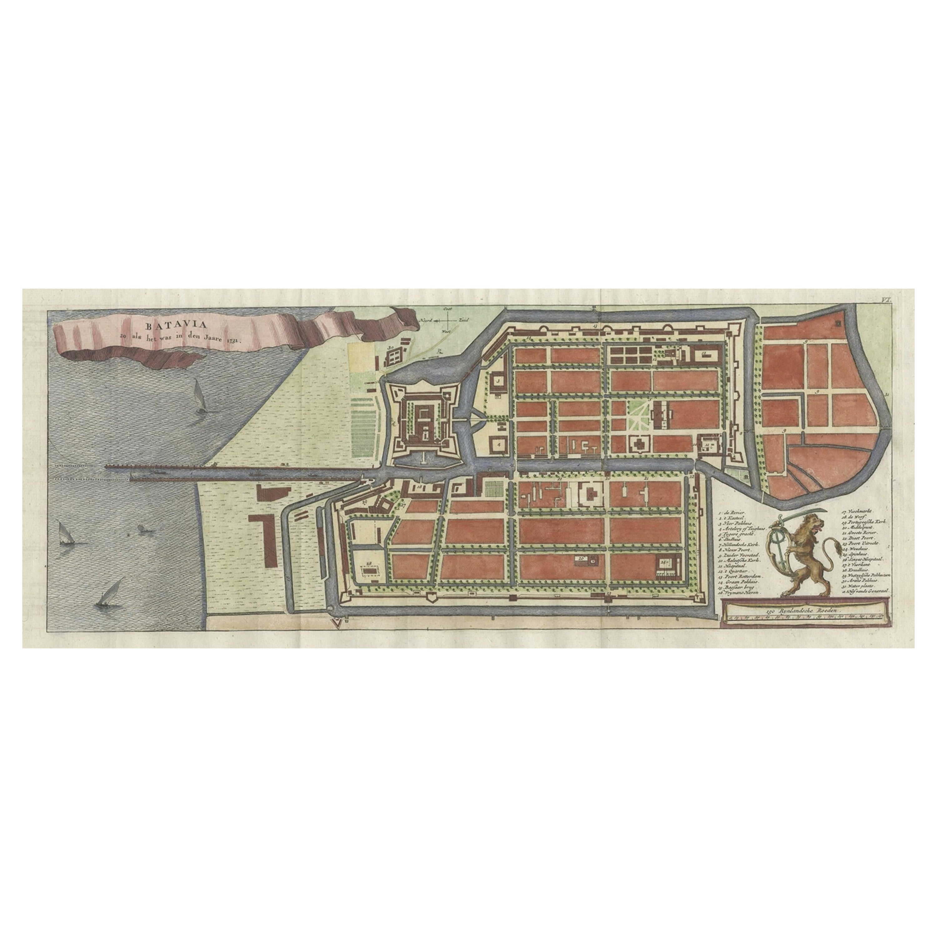
- Antique Map of Batavia, Nowadays Jakarta, the Capital of Indonesia, 1782Located in Langweer, NLAntique map Batavia titled 'Batavia zo als het was in den Jaare 1731'. Old map of the city of Batavia (Jakarta) in Indonesia. Originates from 'Batavia, de Hoofdstad van Neerlands O. ...Category
Antique 18th Century Maps
MaterialsPaper
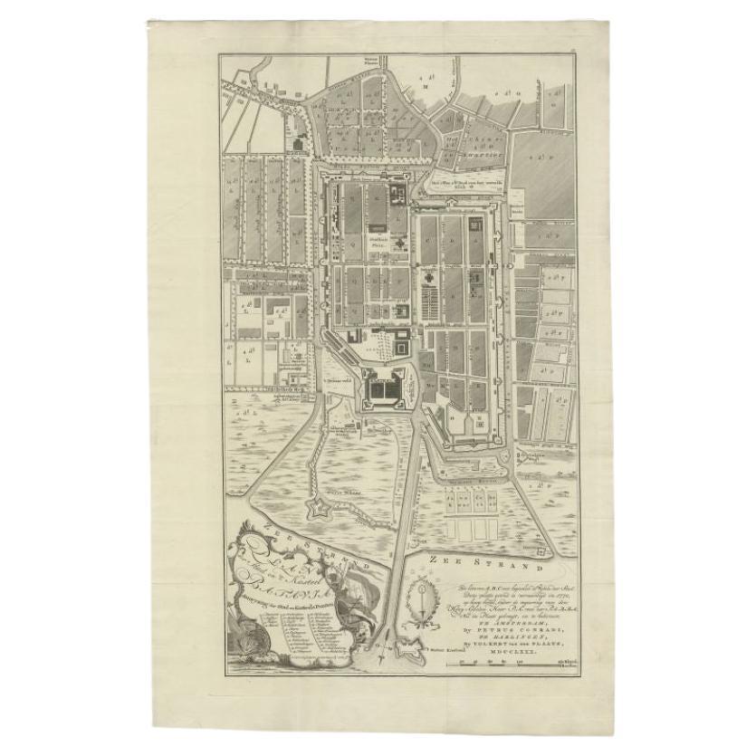
- Antique Plan of Batavia, Nowadays Jakarta, Indonesia, 1780Located in Langweer, NLAntique map titled 'Plan der Stad en 't Kasteel Batavia'. A very rare late 18th century detailed plan of Batavia with an alpha-numeric key showing the main areas and buildings (only ...Category
Antique 18th Century Maps
MaterialsPaper
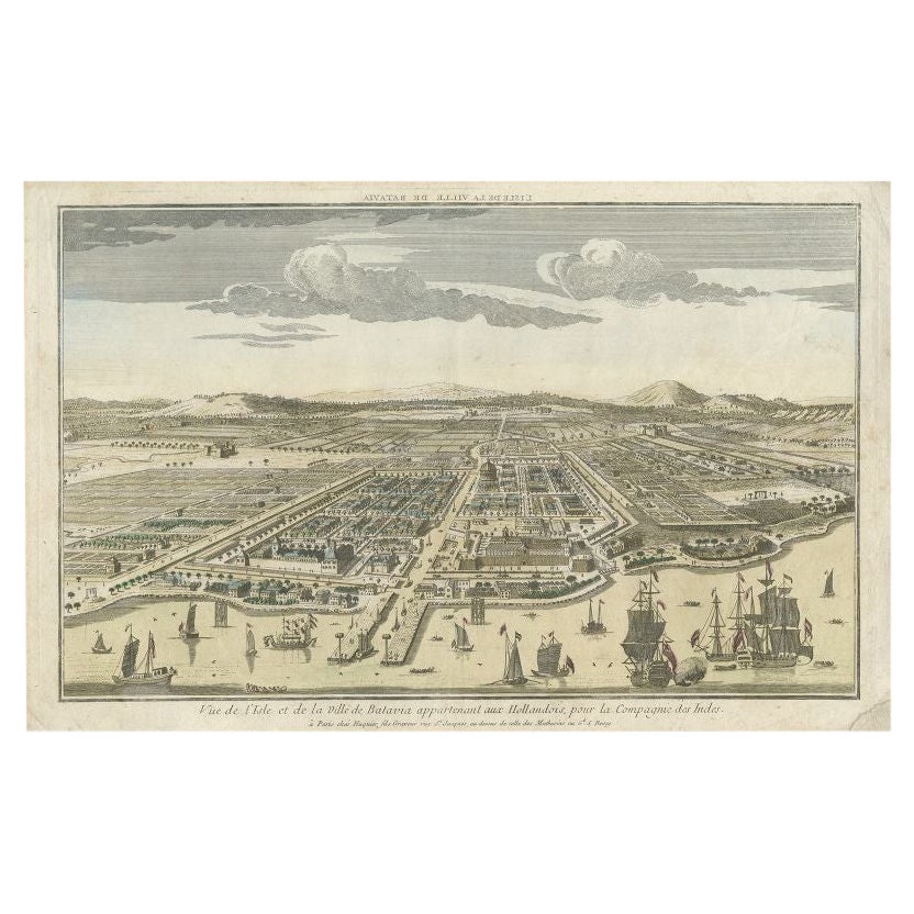
- Antique Print of Batavia or nowadays Jakarta, Indonesia, c.1755Located in Langweer, NLAntique print titled 'Vue de l'Isle et de la ville de Batavia appartenant aux Hollandois'. Beautiful view of the island and the city of Batavia belonging to the Dutch, for the India ...Category
Antique 18th Century Prints
MaterialsPaper
- Antique Map of Batavia, Dutch East Indies, Nowadays Jakarta, Indonesia, ca.1669Located in Langweer, NLAntique map titled 'Ware afbeeldinge wegens het Casteel ende Stadt Batavia gelegen opt groot Eylant Java Anno 1679. Plan de la Ville et du Chateau de Batavia en l'Isle de Iava. 1679....Category
Antique 1660s Maps
MaterialsPaper
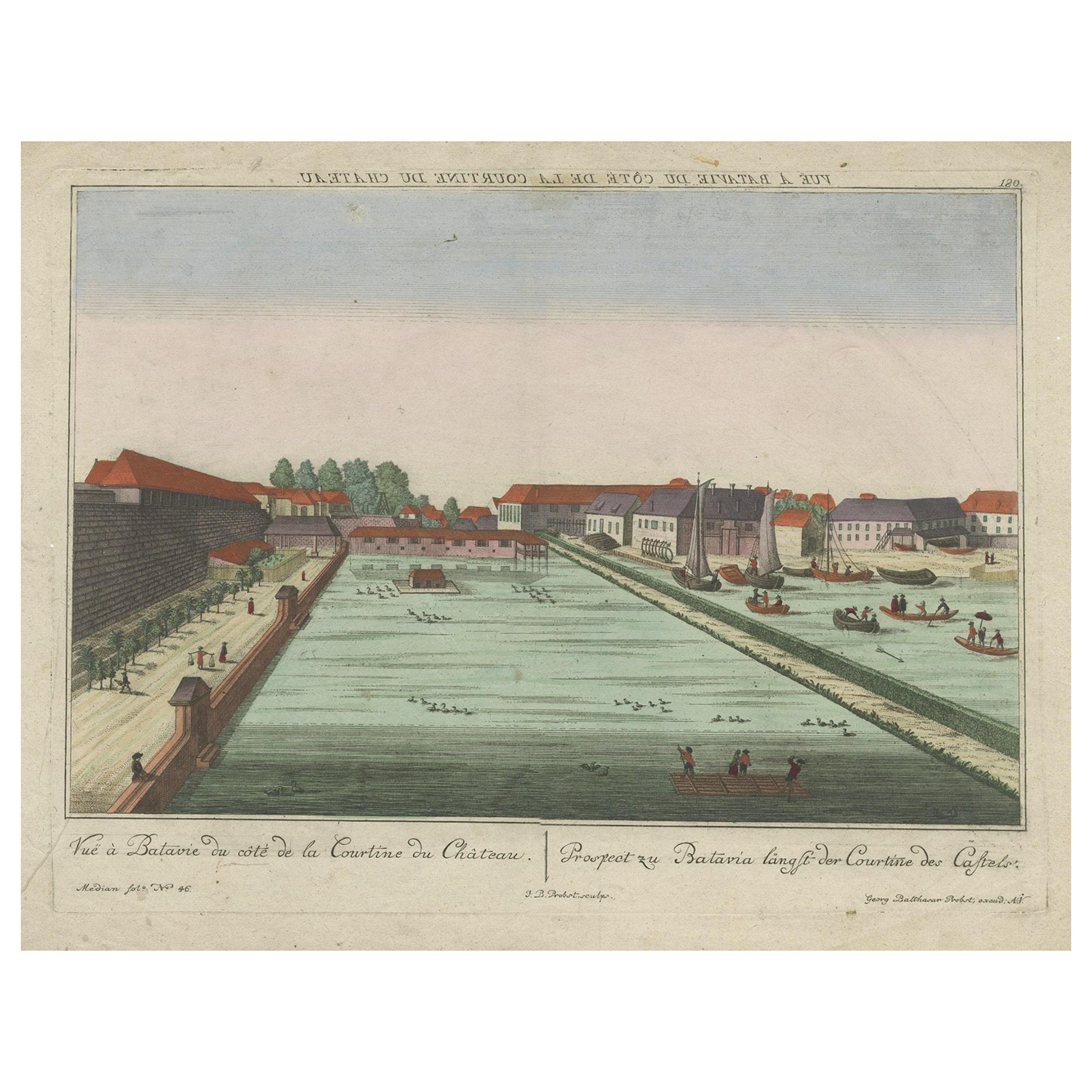
- Antique Print of Batavia Castle in Nowadays Jakarta, Indonesia, circa 1770Located in Langweer, NLAntique print titled 'Vue a Batavie du côte de la Courtine du Château - Prospect zu Batavia längst der Courtine des Castels'. Scarce view of Batavia Castle, present day Djakarta, Ind...Category
Antique 18th Century Prints
MaterialsPaper
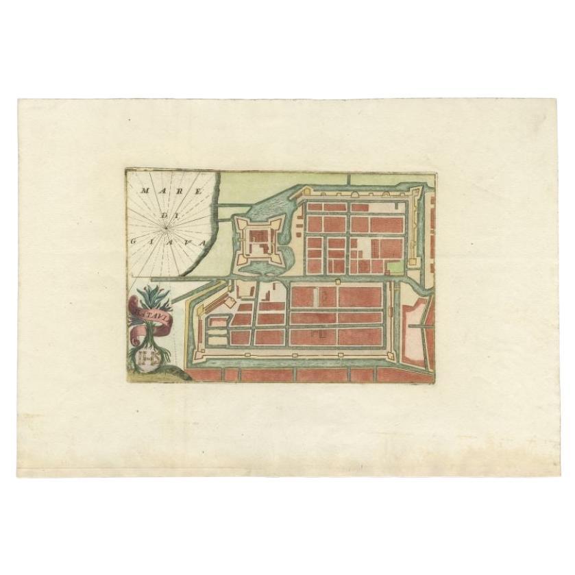
- Antique Plan of Batavia in the Dutch East Indies or Nowadays Jakarta, IndonesiaLocated in Langweer, NLRare plan of Batavia titled 'Batavia'. With 'IHS' monogram, symbolizing Jesus Christ. Source unknown, to be determined. Artists and Enrgavers: Anonymous. Condition: Very good,...Category
Antique 18th Century Maps
MaterialsPaper


You May Also Like
- Antique Hand Colored Framed Map of EuropeLocated in West Palm Beach, FLAntique reproduction copied from an edition dated 1595 by Ortelius.Category
Antique Late 19th Century Maps
- Original Antique Map of Indonesia, 1861Located in St Annes, LancashireGreat map of Indonesia Drawn and engraved by Edward Weller Original color Published in The Weekly Dispatch Atlas, 1861 Repairs to minor e...Category
Antique 1860s English Victorian Maps
MaterialsPaper

- 1864 Map of North America, Antique Hand-Colored Map, by Adolphe Hippolyte DufourLocated in Colorado Springs, COOffered is a map of North America entitled Amerique du Nord from 1864. This rare, separately published wall map was produced by Adolphe Hippolyte Dufour. This map includes vibrant an...Category
Antique 1860s French Maps
MaterialsPaper
- Staffordshire 1645 Hand Colored Antique Print Staffordiensis Comitatvs MapLocated in GBWe are delighted to offer for sale this lovely antique Atlas page map of Staffordshire printed in 1645 Amsterdam Staffordiensis Comitatvs Vulgo This o...Category
Antique Early 1800s English Georgian Maps
MaterialsPaper
- Framed 1839 Hand Colored Map of the United StatesLocated in Stamford, CTFramed hand colored map of the United States of America from 1839. Newly framed in a giltwood frame.Category
Antique 1830s American American Classical Maps
MaterialsGiltwood, Paper, Glass
- Framed 1820s Hand Colored Map of the United StatesLocated in Stamford, CTFramed 1820s hand colored map photos of North America and South America. As found framed in giltwood frame.Category
Antique 1820s American Spanish Colonial Maps
MaterialsGiltwood, Paper, Glass


Recently Viewed
View AllMore Ways To Browse
Map Of Lebanon
Bad Bentheim
Wenceslas Hollar
English County Maps By Blaeu
Von Meer
Minature Map
Anguilla Map
James Calvert Smith
Herefordshire Antique Map
Hertfordshire Antique Map
Antique Map Of Alabama
Australasia Antique Map
Huntingdonshire Antique Map
Moldova Antique Map
Montreal Map
Tennessee Map
Antique Furniture Perth Australia
Antique Maps Perth