Spanish Maps
Recent Sales
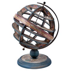
Spanish Armillary Sphere of Polychrome Wood, Paper and Iron, Early 20th Century
By Europa Antiques
Located in Madrid, ES
Spanish armillary sphere of polychrome wood, paper and iron,
Early 20th century
Measures: 35 x 26cm
Good condition.
Category
20th Century Modern Spanish Maps
Materials
Iron
H 13.78 in Dm 10.24 in
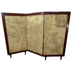
Arts & Crafts Wooden Screen with Madrid Map Engraving
Located in Valladolid, ES
An amazing wooden screen, Arts & Crafts, circa 1900, with an engraving. A Madrid map, from the same epoca. The original engraving was made in 1656 by Pedro ...
Category
Early 20th Century Arts and Crafts Spanish Maps
Materials
Hardwood, Parchment Paper
Decorative World Ball with Wooden Foot, 20th Century
Located in Mombuey, Zamora
Beautiful and elegant ball of the world to decorate any studio, living room or bedroom, it is small, with the base about 26 cm high and 10 wide.
Category
Mid-20th Century Other Spanish Maps
Materials
Wood
Terrestrial Globe Ice Bucket, 20th Century
Located in Mombuey, Zamora
Beautiful ice bucket in the shape of a world ball
It has an eagle with open wings at the top
Beautiful and elegant piece
Serve your cocktail with e...
Category
Mid-20th Century Other Spanish Maps
Materials
Wood
Decorative World Ball with Wooden Foot, 20th Century
Located in Mombuey, Zamora
Beautiful and elegant ball of the world to decorate any studio, living room or bedroom, it is small, with the base about 26 cm high and 10 wide.
Category
Mid-20th Century Other Spanish Maps
Materials
Wood
19th Century Map Imperial Court of Austria Habsburgs
Located in London, GB
This is an antique map of the State of the Imperial Court and the hereditary states of the House of Austria, with their various chancelleries, circa 1820.
The map is very detailed and shows the various branches of the Habsburgs territory.
It is very clean and in good condition and is in a beautiful gilded frame.
Provenance:
I bought this on my last buying trip to Madrid, and it bears the stamp, on the rear, of the " Libreria Margarita de Dios" of Madrid.
Condition:
In excellent condition, please see photos for confirmation of condition.
Dimensions in cm:
Height 61 x width 69.5 x depth 3
Dimensions in inches:
Height 2 feet, 0 inches x width 2 feet, 3 inches x depth 1 inch
The House of Habsburg, also spelled Hapsburg, was one of the most important royal houses of Europe. The throne of the Holy Roman Empire was continuously occupied by the Habsburgs between 1438 and 1740. The house also produced emperors and kings of the Kingdom of Bohemia, Kingdom of England, Kingdom of France, Kingdom of Germany, Kingdom of Hungary, Empire of Russia, Kingdom of Croatia, Second Mexican Empire...
Category
1820s Antique Spanish Maps
1768 Map of Texas by Josef Antonio de Alzate y Ramirez
Located in San Francisco, CA
Map of Texas titled Nuevo Mapa Geografico de la America Septentrional by Josef Antonio de Alzate y Ramirez (1737-1799.) A corresponding member of the Fren...
Category

