Items Similar to Boat Blueprint Showing the Sand Piper


Want more images or videos?
Request additional images or videos from the seller
1 of 13
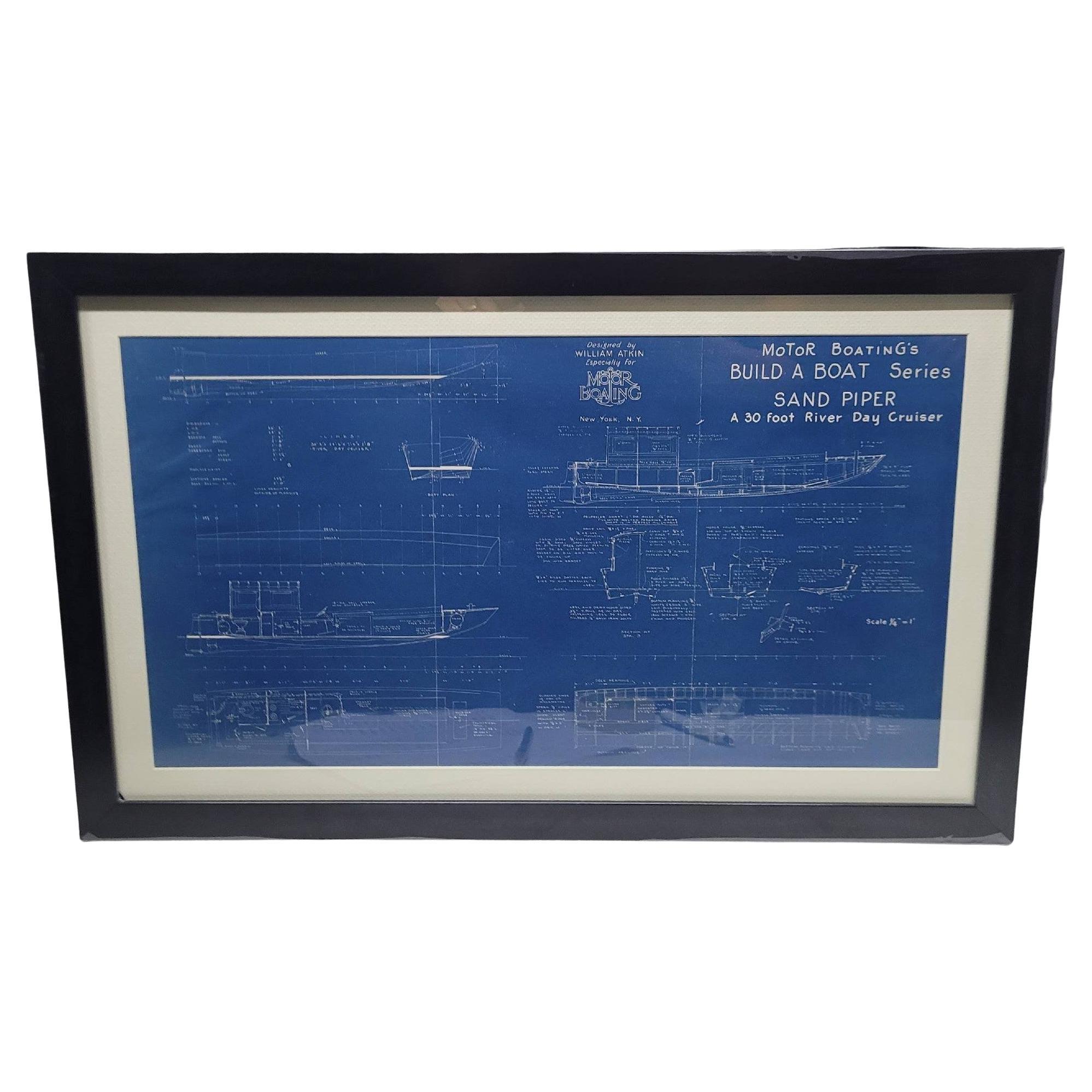
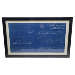
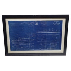
Boat Blueprint Showing the Sand Piper
$930
£706.49
€813.52
CA$1,330.46
A$1,459.39
CHF 752.55
MX$17,430.90
NOK 9,544.62
SEK 8,953.94
DKK 6,079.39
About the Item
Motor Boating Publishing plan for a thirty foot day cruiser. Designd by William Atkin. The vessel is shown in great detail. Circa 1937 matted and framed.
Weight: 7 lbs.
Overall Dimensions: 19"H x 28"W
Made: America
Material: Paper
Date: 1937
- Dimensions:Height: 19 in (48.26 cm)Width: 28 in (71.12 cm)Depth: 1 in (2.54 cm)
- Materials and Techniques:
- Place of Origin:
- Period:
- Date of Manufacture:1937
- Condition:
- Seller Location:Norwell, MA
- Reference Number:Seller: 86471stDibs: LU1741238675032
About the Seller
5.0
Vetted Professional Seller
Every seller passes strict standards for authenticity and reliability
Established in 1967
1stDibs seller since 2015
418 sales on 1stDibs
Typical response time: 1 hour
- ShippingRetrieving quote...Shipping from: Norwell, MA
- Return Policy
Authenticity Guarantee
In the unlikely event there’s an issue with an item’s authenticity, contact us within 1 year for a full refund. DetailsMoney-Back Guarantee
If your item is not as described, is damaged in transit, or does not arrive, contact us within 7 days for a full refund. Details24-Hour Cancellation
You have a 24-hour grace period in which to reconsider your purchase, with no questions asked.Vetted Professional Sellers
Our world-class sellers must adhere to strict standards for service and quality, maintaining the integrity of our listings.Price-Match Guarantee
If you find that a seller listed the same item for a lower price elsewhere, we’ll match it.Trusted Global Delivery
Our best-in-class carrier network provides specialized shipping options worldwide, including custom delivery.More From This Seller
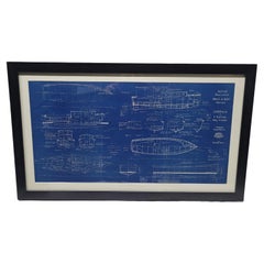
View AllBoat Blueprint of the "Sand Piper" from Motor Boating Publications
Located in Norwell, MA
Boat blueprint from Motor Boating's build a boat series. This blueprint shows a William Atkin design of the "Sand Piper", A 30 foot river day cruiser. Atkin designed more than 700 bo...
Category
Vintage 1930s North American Nautical Objects
Materials
Paper
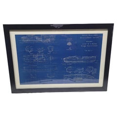
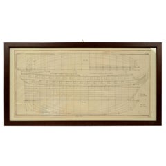
Boat Blueprint of the "Melody" from Motor Boating Publications
Located in Norwell, MA
Boat blueprint from Motor Boating's Build a Boat series. This blueprint shows a William Atkin design of the thirty seven foot bridge deck cruiser "Melody."...
Category
Vintage 1970s North American Nautical Objects
Materials
Paper
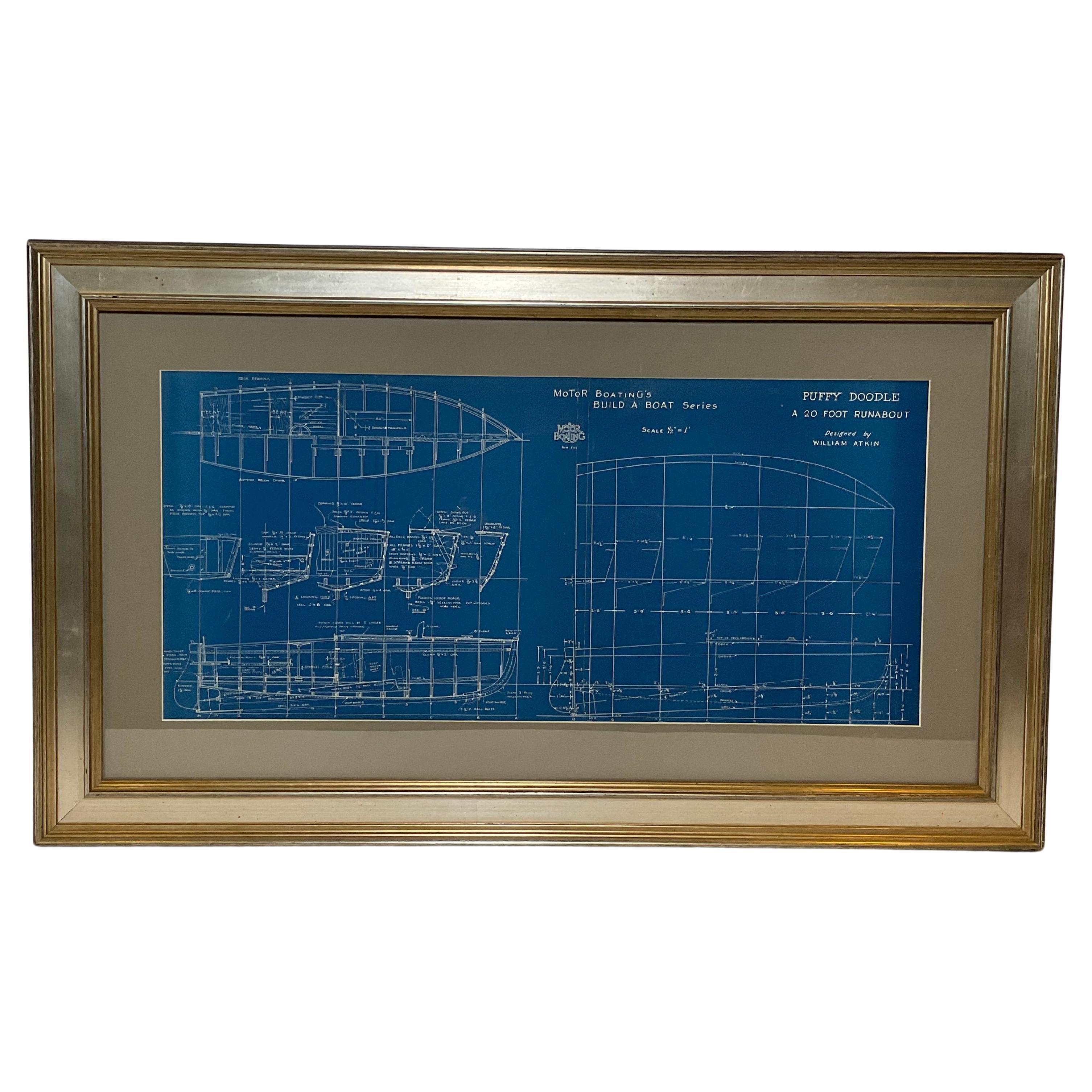
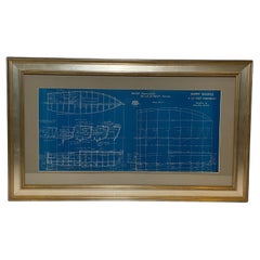
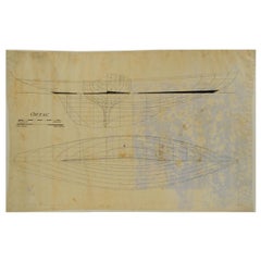
Boat Blueprint of the Runabout "Puffy Doodle"
Located in Norwell, MA
Speedboat plan by William Atkin of "Puffy Doodle", A 20 foot runabout designed by William Atkin. The hull lines and offset are shown in great detail. Printed by Motor Boating Publish...
Category
Vintage 1930s North American Nautical Objects
Materials
Paper
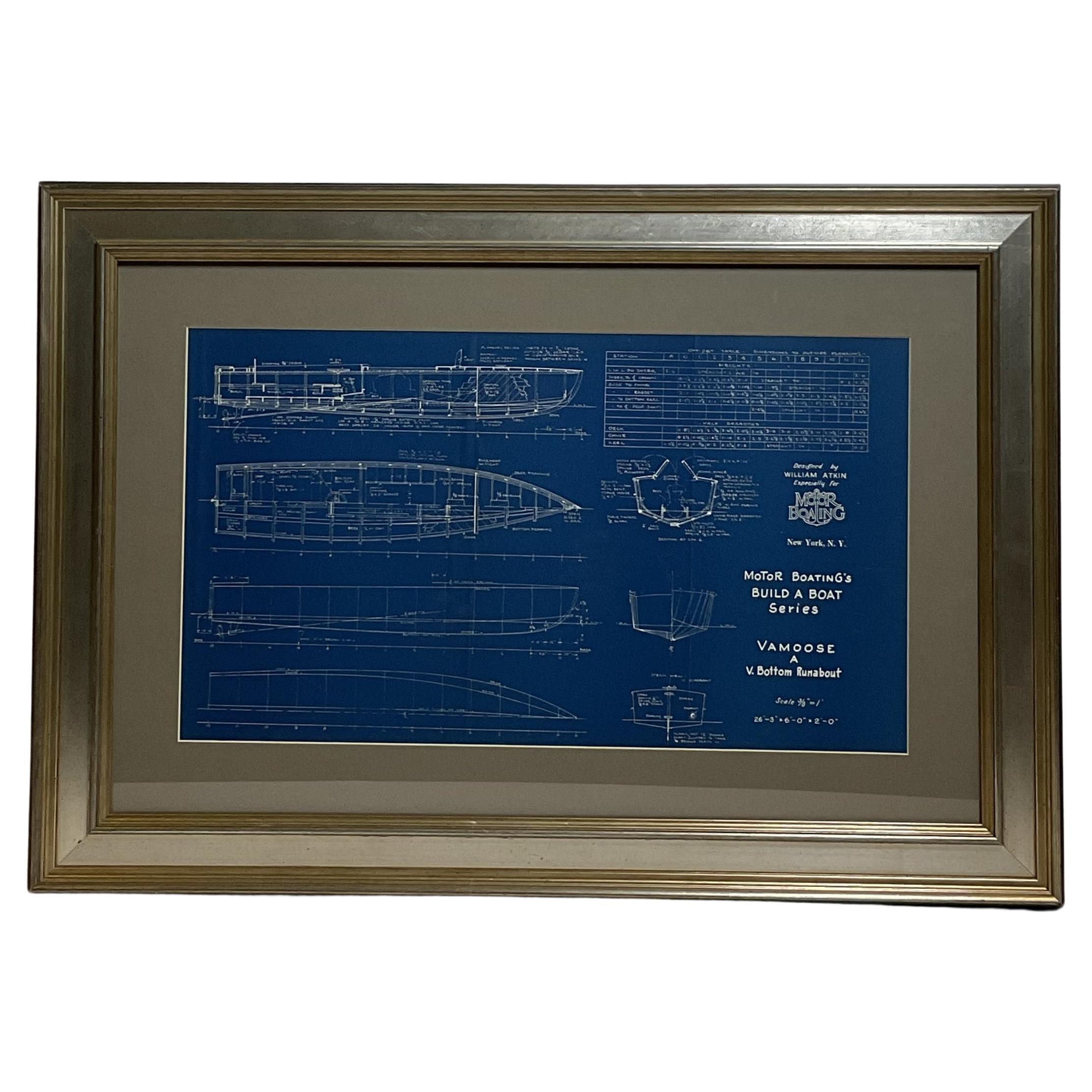
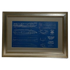
Boat Blueprint of the Runabout Vamoose
Located in Norwell, MA
1930's boat plan by Naval Architect William Atkin of the V bottom runabout "Vamoose". The plan is in great detail showing hull lines, profile, deck plan, et...
Category
Vintage 1930s North American Nautical Objects
Materials
Paper
Boat Blueprint of the "Slopoke" from Motor Boating Publications
Located in Norwell, MA
Boat blueprint from Motor Boating's build a boat series. This blueprint shows a William Atkin design of the "Slopoke", A 44 foot cruising house boat. Atkin designed more than 700 boa...
Category
Vintage 1930s North American Nautical Objects
Materials
Paper
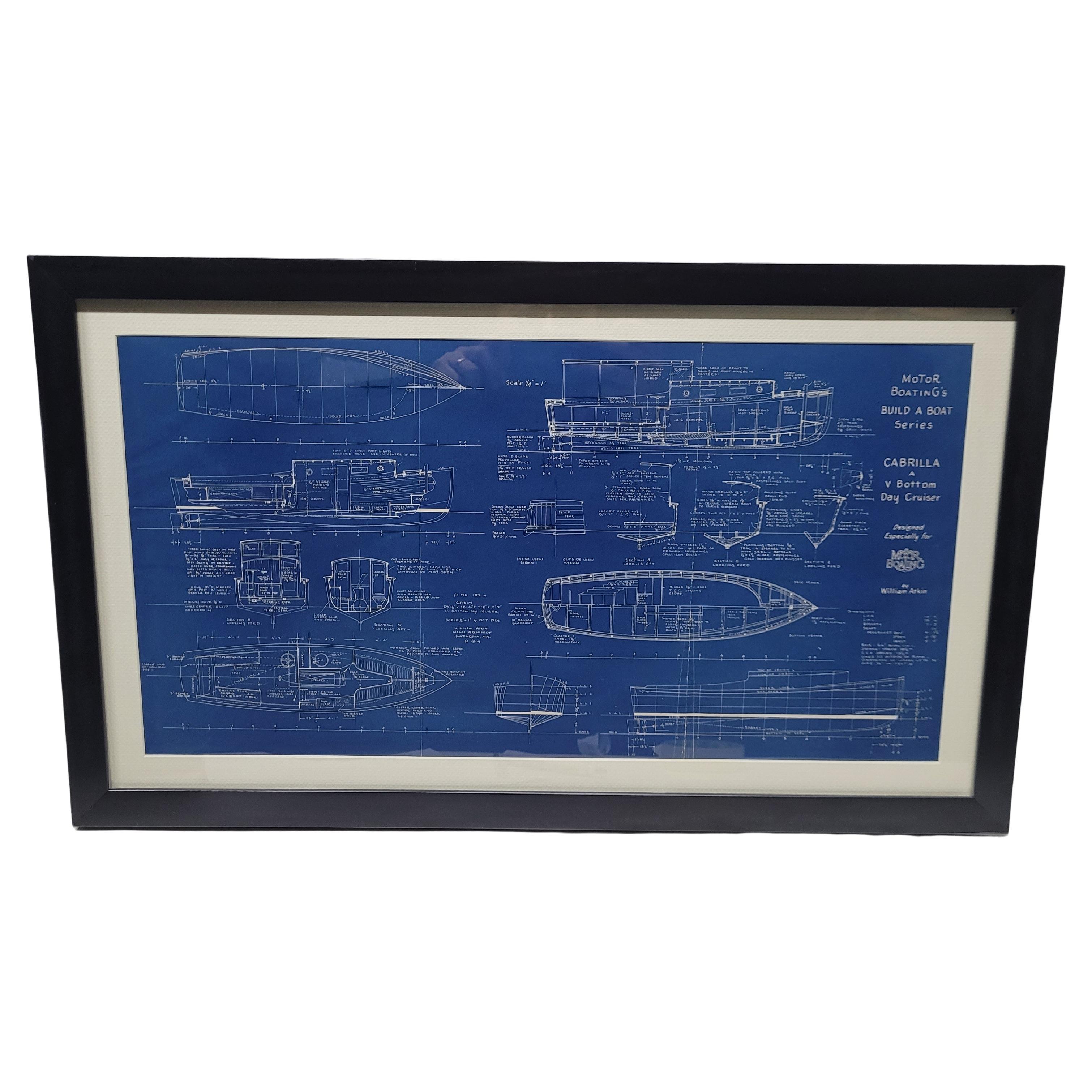
Boat Blueprint of the "Cabrilla" from Motor Boating Publications
Located in Norwell, MA
Boat blueprint from Motor Boating's Build a Boat series. This blueprint shows a William Atkin design of the V bottom day cruiser "Cabrilla." Atkin designed more than 700 boats. Lloyd...
Category
Vintage 1970s North American Nautical Objects
Materials
Paper
You May Also Like
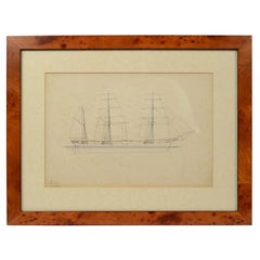
Old Nautical Print by Engraving on Copper Plate from the Panckoucke Encyclopédie
Located in Milan, IT
Print by engraving on copper plate from the Panckoucke Encyclopédie méthodique, end of the 18th century, volume Marine Planches (more than 1,500 figures dealing with all subjects on the marina: planes, construction, carpentry, tree trunks, armaments of maneuvers, ropes, sails, artillery, ship maneuvers and combat tactics). This is the plate n. 149, page. 166 fig. 1209-1212; with frame cm 57.8 x 31.8. The prospect of the side of a ship is depicted. The Print has the "Benard direxit...
Category
Antique 1790s French Prints
Materials
Paper
1930s Nautical Old Ship Project Ortac Morgan Giles shipyard Uffa Fox archives
Located in Milan, IT
Project of the ship Ortac; launched in 1937 at the Morgan Giles shipyard, length 10.68m overall, width 3.39m, it has a mast rather tail-heavy and it won many races of RORC class.
Me...
Category
Vintage 1930s British Nautical Objects
Materials
Paper

1930s Vintage Project of the Ship Ortac Morgan Giles shipyard Uffa Fox archives
Located in Milan, IT
Project of the ship Ortac; launched in 1937 at the Morgan Giles shipyard, length 10.68m overall, width 3.39m, it has a mast rather tail-heavy and it won many races of RORC class. Mea...
Category
Vintage 1930s British Prints
Materials
Paper
Print No. 1 of 400 Depicting a Nautical Schooner Made in the Mid-19th Century
Located in Milan, IT
Print depicting a schooner, no. 1 of 400 copies signed Z21, made in the mid-19th century. Non-coeval briarwood frame; measures with frame 50 x 40 cm.
Category
Antique 1850s British Nautical Objects
Materials
Paper
"Ships of War - Screw Gun Boat" lithograph by Day & Son, 1864
Located in London, GB
A Victorian framed print of "SHIPS OF WAR - Screw Gun Boat" by Day and Son, Lithographers to the Queen. Plate 84: The Modern System of Naval Architecture, Joh...
Category
Antique Mid-19th Century English Nautical Objects
Materials
Paper
1930s Antique Project of the Ship Ortac Morgan Giles Shipyard Uffa Fox archives
Located in Milan, IT
Project of the ship Ortac; launched in 1937 at the Morgan Giles shipyard, length 10.68m overall, width 3.39m, it has a mast rather tail-heavy and it won many races of RORC class. Mea...
Category
Vintage 1930s British Nautical Objects
Materials
Paper
More Ways To Browse
Boat Plans
Nautical Antiques Ships Wheel
Sea Captains Furniture
Ships Brass Compass
Yacht Club Burgee
Antique Brass Portholes
Wood Pulley Block
Antique Pond Yachts
Pond Boat
Pond Boats
Vintage Framed Flag
Vintage Gaff
Yacht Plates
Antique Nautical Portholes
Antique Scrimshaw
Antique Ships Porthole
Antique Tiller
Used Bronze Propeller