Items Similar to Cosmgraphy and Astrology, 1686 by Richard Blome from the First Edition

Want more images or videos?
Request additional images or videos from the seller
1 of 12
Cosmgraphy and Astrology, 1686 by Richard Blome from the First Edition
$4,025.43
£3,000
€3,472.14
CA$5,657.14
A$6,151.33
CHF 3,241.15
MX$74,720.86
NOK 40,747.83
SEK 38,197.80
DKK 26,055.41
About the Item
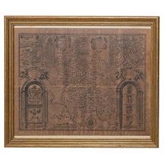
Cosmography & Astrology
Large oval engraved plate with inscriptions outlining the various parts of cosmography and astronomy; below, two emblematic figures with scientific instruments either side. Lettered with title, dedication, and various inscriptions. To his Excellency Roger Palmer, Earle of Castelmain and Baron of Limerick in Ireland, Embassador Extraordinary from his majesty King James II to his Holyness Pope Innocent 11th anno dom 1686. This plate is humbly DD by Richard Blome. On paper and retaining its original coloring.
Sheet width 26 ½ cm., 10 ½ in., height 41 ½ cm., 16 ½ in.,
In a part-gilded Sansovino frame, carved with moons and suns
Frame Length 43 cm., 17 in., Height 58 cm., 23 in.
This engraving is an illustration from the first part of the first edition of The Gentleman’s Recreation, published by S. Roycroft in 1686, which was Blome’s best known work outside the realm of cartography and includes some of the earliest published illustrations of a globe and aspects of cosmography & astrology.
Literature: Related to : Engraving 1847,0306.275 in the British Museum, Department of Prints & Drawings, acquired in 1847
The Gentleman's Recreations In Three Parts was comprised of First Part: Introduction to the Liberal Arts, Second Part: Of Horsemanship, Hawking, Hunting.Fowling, Fishing, etc. and Third Part: Laws of the Forest and Game. The first part has 31 plates illustrating liberal arts subjects, 19 of which were oval plates with tables in the center and decorative borders depicting people engaged in activities such as Rhetoric, Logic, Astronomy, Astrology, Cosmography, Navigation and Geography. The second part includes 50 copperplate engravings on horses and different types of hunting activities, including shooting, fishing and falconry.
Richard Blome was among the most active publishers of cartographic and illustrated books in late 17th century London. He was the first publisher in England for 40 years to prepare a new folio world atlas, the first in over 60 years to publish a new set of folio county maps, the first to seriously plan an illustrated description of London, and the first to plan a series of volumes related to the various world continents. In the 1680s, Blome issued some illustrated books, including The Gentleman's Recreation, The History of The Old Testament and a three-volume translation of the works of French philosopher Rene Descartes.
Blome included fortification in his vast compendium of the arts and sciences recommended to the English gentleman, and he had the relevant section written by George Leslie. A variety of alternative methods and systems are presented, indicating different authorities and traditions of practice within the developing domain of fortification.
Signed/Inscribed: 1686.
- Creator:Richard Blome (Maker)
- Dimensions:Height: 16.34 in (41.5 cm)Width: 10.44 in (26.5 cm)Depth: 0.04 in (1 mm)
- Style:Charles II (Of the Period)
- Materials and Techniques:Paper,Glazed
- Place of Origin:
- Period:1680-1689
- Date of Manufacture:1686
- Condition:
- Seller Location:BUNGAY, GB
- Reference Number:1stDibs: LU3867315797902
About the Seller
5.0
Vetted Professional Seller
Every seller passes strict standards for authenticity and reliability
Established in 1985
1stDibs seller since 2018
102 sales on 1stDibs
Typical response time: 13 hours
- ShippingRetrieving quote...Shipping from: BUNGAY, United Kingdom
- Return Policy
Authenticity Guarantee
In the unlikely event there’s an issue with an item’s authenticity, contact us within 1 year for a full refund. DetailsMoney-Back Guarantee
If your item is not as described, is damaged in transit, or does not arrive, contact us within 7 days for a full refund. Details24-Hour Cancellation
You have a 24-hour grace period in which to reconsider your purchase, with no questions asked.Vetted Professional Sellers
Our world-class sellers must adhere to strict standards for service and quality, maintaining the integrity of our listings.Price-Match Guarantee
If you find that a seller listed the same item for a lower price elsewhere, we’ll match it.Trusted Global Delivery
Our best-in-class carrier network provides specialized shipping options worldwide, including custom delivery.More From This Seller
View AllRoad Map Britannia No 25 London to the Lands End, John Ogilby Brown Gilded Frame
By John Ogilby
Located in BUNGAY, SUFFOLK
The road from London to the lands end. Commencing at the Standard in Cornhill and extending to Senan in Cornwall. By John Ogilby His Majesties Cosmographer. A road map from Britannia, 1675/6. No 25.
Continuing 308 miles, 3 furlongs.
London Southwark to Brentford, to Hampton Court, to Hounslow, to Windsor, to Cobham, to Farnham, to Basingstoke to Winchester
The handcoloured sheet free floated. In a brown painted and gilded, ogee moulded frame. Some foxing and creasing, uneven edge of sheet, all commensurate with age
Provenance : purchased as pair from a collector with no 15 London to St David's. Framed as a pair.
Sheet width 48cm., 19 ”., height 38cm., 15 “
Frame width 66.5cm., 26”., height 56cm., 22 ”
In a remarkable life John Ogilby pursued, several careers, each ending in misfortune, and yet he always emerged undeterred, to carry on. His modern reputation is based on his final career, started i
Black Linear Border around Map Length 44cm., 17 1/8" Height 32cm., 12 1/2"
Full Sheet Length 58cm., 22 3/4" Height 38cm., 15"
Frame Length 66cm., 26"., Height 56cm., 22"
In a remarkable life John Ogilby pursued, several careers, each ending in misfortune, and yet he always emerged undeterred, to carry on. His modern reputation is based on his final career, started in his sixty-sixth year, as a publisher of maps and geographical accounts.
Ogilby was born outside Dundee, in 1600, the son of a Scottish gentleman. While he was still a child, the family moved to London. When the elder Ogilby was imprisoned for debt, the young John invested his savings in a lottery, won a minor prize, and settled his father's debts. Unfortunately, not enough money was left to secure John a good apprenticeship; instead, he was apprenticed to a dance master. Ogilby was soon dancing in masques at court but, one day, while executing a particularly ambitious leap, he landed badly. The accident left him with a permanent limp, and ended his dancing career. However, he had come to the attention of Thomas Wentworth, later Earl of Strafford, Charles I's most senior minister. Ever one to exploit his contacts, Ogilby became a dance instructor in Strafford's household.
When Strafford was sent to Ireland, Ogilby accompanied him as Deputy-Master of the Kings Revels, and then Master of Revels. In Dublin, he built the New Theatre, in St. Werburgh Street, which prospered at first, but the Irish Rebellion, in 1641, cost Ogilby his fortune, which he estimated at £2,000, and almost his life. After brief service as a soldier, he returned to England, survived shipwreck on the way, and arrived back penniless.
On his return, Ogilby turned his attention to the Latin classics, as a translator and publisher. His first faltering attempt, in 1649, was a translation of the works of Virgil, but after his marriage to a wealthy widow the same year, his publishing activities received a considerable boost. One means by which Ogilby financed these volumes was by subscription, securing advance payments from his patrons, in return for including their name and coats-of-arms on the plates of illustrations. Another approach was to secure a patron, preferably in the court circle. Ogilby's first patron was Strafford, who found out too late that all leading ministers are dispensable when Charles I assented to his execution in 1641. As he re-established himself, Ogilby sought a new patron, the King himself.
In 1661, Ogilby was approached to write poetry for Charles II's coronation procession; he later published 'The Relation of His Majesties Entertainment Passing Through the City of London', and a much enlarged edition the following year, which included a fine set of plates depicting the procession. Royal favour was bestowed in 1674 when John Ogilby received the title of 'His Majesty's Cosmographer and Geographick Printer' with a salary of £13.6s.8d per annum.
In 1665, Ogilby left London to avoid the Plague then ravaging the capital. The following year, in the Great Fire of London, Ogilby claimed that he lost his entire stock of books valued at some £3,000, as well as his shop and house, leaving him worth just £5.
As he sought to restore his fortunes, Ogilby was already looking in new directions. The initial opportunity he seized on was the reconstruction of London's burnt-out centre. He secured appointment as a "sworn viewer", whose duty was to establish the property boundaries as they existed before the Fire. Ogilby was assisted in the project by his step-grandson, William Morgan...
Category
Antique Late 17th Century British Charles II Maps
Materials
Paper
Road Map Britannia No 15 London to St Davids John Ogilby Brown Gilt Frame
By John Ogilby
Located in BUNGAY, SUFFOLK
The continuation of the road from London to St Davids, commencing at Abingdon Com Berks and extending to Monmouth By John Ogilby Esq, His Majesties Cosmographer. From Abingdon to Farringdon, to Lechlade, to Fairford, to Barnsley to Gloucester showing Monmouth as the destination. A road map from Britannia, 1675/6. No 15.
Hand coloured and floated on a cream mount within a brown painted and gilded ogee frame. Some foxing and creasing, uneven edge of sheet, all commensurate with age
Provenance : purchased as pair from a collector with no 25 London to Lands End. Framed as a pair.
Sheet width 46.5cm., 18 ¼ ”., height 37.5cm., 14 ¾ “
Frame width 66.5cm., 26”., height 56cm., 22 ”
In a remarkable life John Ogilby pursued, several careers, each ending in misfortune, and yet he always emerged undeterred, to carry on. His modern reputation is based on his final career, started in his sixty-sixth year, as a publisher of maps and geographical accounts.
Ogilby was born outside Dundee, in 1600, the son of a Scottish gentleman. While he was still a child, the family moved to London. When the elder Ogilby was imprisoned for debt, the young John invested his savings in a lottery, won a minor prize, and settled his father's debts. Unfortunately, not enough money was left to secure John a good apprenticeship; instead, he was apprenticed to a dance master. Ogilby was soon dancing in masques at court but, one day, while executing a particularly ambitious leap, he landed badly. The accident left him with a permanent limp, and ended his dancing career. However, he had come to the attention of Thomas Wentworth, later Earl of Strafford, Charles I's most senior minister. Ever one to exploit his contacts, Ogilby became a dance instructor in Strafford's household.
When Strafford was sent to Ireland, Ogilby accompanied him as Deputy-Master of the Kings Revels, and then Master of Revels. In Dublin, he built the New Theatre, in St. Werburgh Street, which prospered at first, but the Irish Rebellion, in 1641, cost Ogilby his fortune, which he estimated at £2,000, and almost his life. After brief service as a soldier, he returned to England, survived shipwreck on the way, and arrived back penniless.
On his return, Ogilby turned his attention to the Latin classics, as a translator and publisher. His first faltering attempt, in 1649, was a translation of the works of Virgil, but after his marriage to a wealthy widow the same year, his publishing activities received a considerable boost. One means by which Ogilby financed these volumes was by subscription, securing advance payments from his patrons, in return for including their name and coats-of-arms on the plates of illustrations. Another approach was to secure a patron, preferably in the court circle. Ogilby's first patron was Strafford, who found out too late that all leading ministers are dispensable when Charles I assented to his execution in 1641. As he re-established himself, Ogilby sought a new patron, the King himself.
In 1661, Ogilby was approached to write poetry for Charles II's coronation procession; he later published 'The Relation of His Majesties Entertainment Passing Through the City of London', and a much enlarged edition the following year, which included a fine set of plates depicting the procession. Royal favour was bestowed in 1674 when John Ogilby received the title of 'His Majesty's Cosmographer and Geographick Printer' with a salary of £13.6s.8d per annum.
In 1665, Ogilby left London to avoid the Plague then ravaging the capital. The following year, in the Great Fire of London, Ogilby claimed that he lost his entire stock of books valued at some £3,000, as well as his shop and house, leaving him worth just £5.
As he sought to restore his fortunes, Ogilby was already looking in new directions. The initial opportunity he seized on was the reconstruction of London's burnt-out centre. He secured appointment as a "sworn viewer", whose duty was to establish the property boundaries as they existed before the Fire. Ogilby was assisted in the project by his step-grandson, William Morgan...
Category
Antique Late 17th Century British Charles II Maps
Materials
Paper
Road Map No43 London to Kings Lynn, Royston to Downham, John Ogilby, Britannia
By John Ogilby
Located in BUNGAY, SUFFOLK
John Ogilby (British 1600-1676) Cosmographer and Geographick Printer to Charles II.
A road map from Britannia, 1675/6. The road from London to Kings Lynn, showing Royston to Downham. In oak and gilded frame.
In a remarkable life John Ogilby pursued, several careers, each ending in misfortune, and yet he always emerged undeterred, to carry on. His modern reputation is based on his final career, started in his sixty-sixth year, as a publisher of maps and geographical accounts.
Ogilby was born outside Dundee, in 1600, the son of a Scottish gentleman...
Category
Antique Late 17th Century British Charles II Maps
Materials
Paper
Map Holy Land La Terre Sainte Engraved van Loon Published N de Fer 1703 French
Located in BUNGAY, SUFFOLK
La Terre Sainte, The Holy Land, Tiree Des Memoires De M.De.La Rue. Par N. de Fer. Geographe de Sa Majeste Catoliq et de Monseigneur le Dauphin. Avec Privil du Roi 1703
Detailed map of the Holy Land from Nicholas de Fer's L'Atlas Curieux ou le Monde. East is oriented at the top.
MAKER Nicolas de Fer 1646-1720
The French cartographer and engraver, Nicolas de Fer, was a master at creating maps that were works of art. The maps that he published were printed during the Baroque period when the decorative arts were characterized by ornate detail. De Fer’s detailed maps and atlases were valued more for their decorative content than their geographical accuracy.
Nicolas de Fer was born in 1646. His father, Antoine de Fer, owned a mapmaking firm. At the age of twelve, Nicolas was apprenticed to a Parisian engraver named Louis Spirinx. The family business was starting to decline when his father died in 1673. Nicolas de Fer’s mother, Genevieve, took over the business after the death of her husband. In 1687 the business was passed on to Nicolas and the profits increased after he took over the firm. Nicolas de Fer was a prolific cartographer who produced atlases and hundreds of single maps. He eventually became the official geographer to King Louis XIV of France and King Philip V...
Category
Antique Early 1700s French Louis XIV Maps
Materials
Paper

Buckingham Both Shyre and Shire John Speed 1610 Gilded Frame
Located in BUNGAY, SUFFOLK
Just purchased more information to follow.
In unrestored condition, the sheet can be cleaned.
Category
Antique 17th Century English Baroque Maps
Materials
Paper
Map Holy Promise Land Canaan Richard Palmer Richard Blome 1687 Joseph Moxon
Located in BUNGAY, SUFFOLK
Canaan comonly called the Holy Land or the Land of Promise, being the Possesion of the Israelites & travelled through by Our Lord & Saviour Iesus Christ and his Apostles. Engraven by Richard Palmer for Richard Blome. 1687
Blome, Richard, 1641-1705. London. 283 x 452 mm. Copperplate.
Probably from an English Bible...
Category
Antique 17th Century British Baroque Maps
Materials
Paper

You May Also Like
Italian Renaissance Style Framed Print Of A Celestial Map "Tychonic Planisphere"
Located in Queens, NY
Italian Renaissance style framed print of a celestial map depicting the beliefs of the Earth is stationary at the center of the planetary system with the Sun and Moon revolving the E...
Category
20th Century Italian Renaissance Paintings
Materials
Brass
Italian Renaissance Style Framed Print of Andreas Cellarius' Celestial Map, Titl
Located in Queens, NY
Italian Renaissance style framed print of a celestial map depicting how the Sun, Moon and other planets revolves around the Earth
Category
20th Century Italian Renaissance Paintings
Materials
Ceramic
Decorative Antique Celestial Map – Zodiac, Stars & Hemel Globe, 1720
Located in Langweer, NL
Antique Celestial Map – Hemel Globe, Zodiac & Constellations by Halma, 1720
This striking double-hemisphere celestial chart, titled Hemel Globe...
Category
Antique Early 18th Century Dutch Maps
Materials
Paper
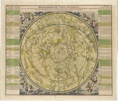
1730 Southern Hemisphere Celestial Chart with Zodiac Signs and Decorative Putti
Located in Langweer, NL
Title: 1730 Southern Hemisphere Celestial Chart with Zodiac Signs and Decorative Putti
Description: This stunning 1730 celestial map, "Hemisphaerium Coeli Australe," showcases the S...
Category
Antique 1730s Prints
Materials
Paper
Theories of Planetary Orbits: A Framed 18th C. Celestial Map by Doppelmayr
By Johann Gabriel Doppelmayr 1
Located in Alamo, CA
This 18th century hand-colored copperplate celestial map by Johann Doppelmayr entitled "Astronomia Comparativa in qua Planetarum Primaria Phaenomena" (Co...
Category
Early 18th Century Landscape Prints
Materials
Engraving

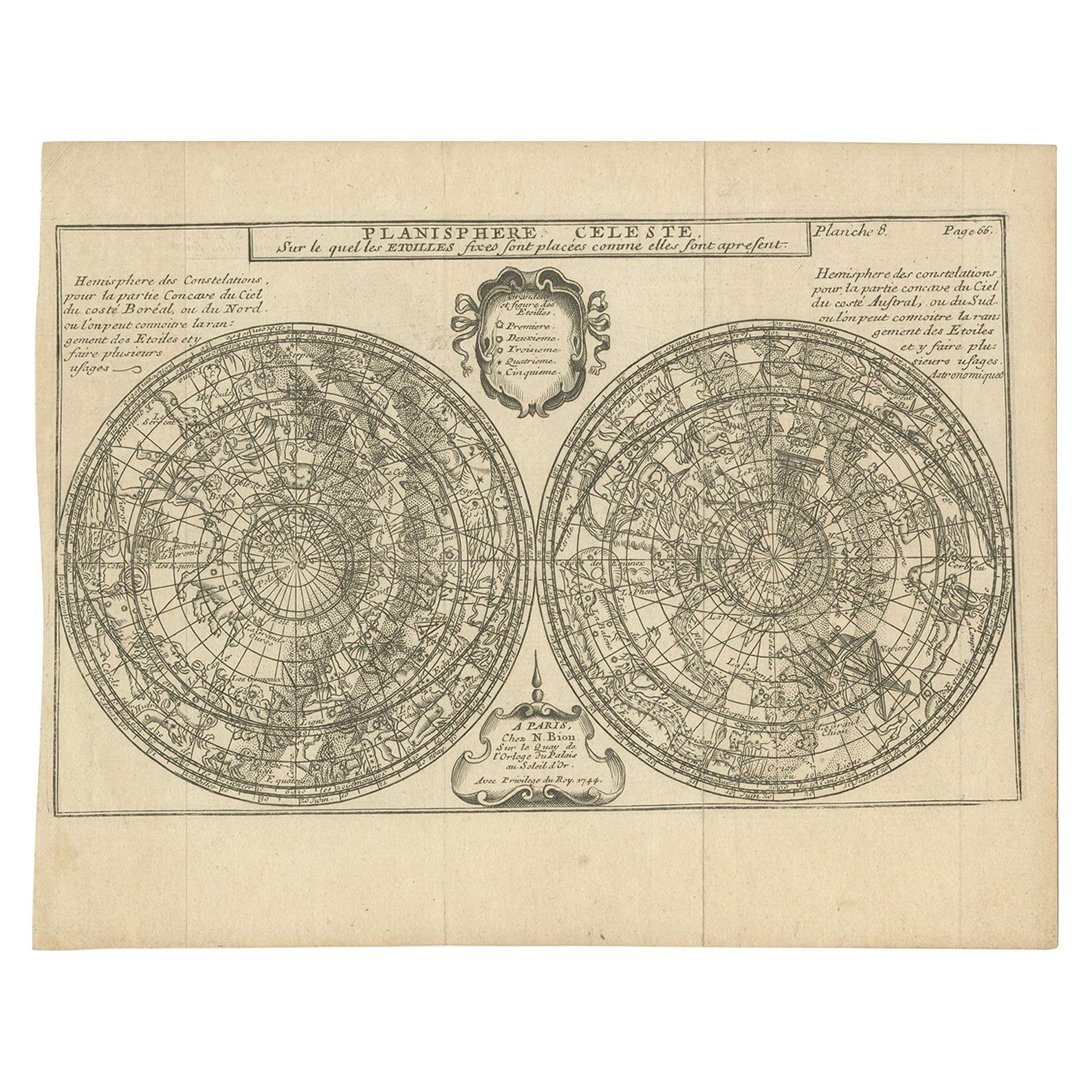
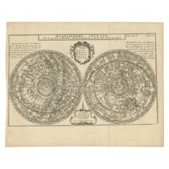
Antique Planisphere with Constellations by Bion, 1751
Located in Langweer, NL
Antique map titled 'Planisphere Celeste'. Planisphere with various constellations. This map originates from 'L'Usage des globes célestes et terrestres et des sphères (..)' by N. Bion...
Category
Antique Mid-19th Century Maps
Materials
Paper
$189 Sale Price
20% Off
More Ways To Browse
Engraving Horses
Astrology Furniture
Antique Falconry
Rene Descartes
Astrology Plate
Astrology Wall Art
Japanese Wall Panels
Abstract Metal Wall Art
Chinese Decorative Panels
English Wall Panels
Grand Tour Plaque
Japanese Wall Plate
Large Ceramic Wall Plates
Palissy Fish Platter
Spanish Tile Art
Terracotta Cherubs
Vintage Ceramic Wall Decor
Antique Wall Pictures