Items Similar to Vintage Mural Wall Chart Treaty of Locarno Weimar Republic End of World War I


Want more images or videos?
Request additional images or videos from the seller
1 of 6
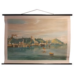
Vintage Mural Wall Chart Treaty of Locarno Weimar Republic End of World War I
About the Item
The vintage pull-down wall chart shows a scene at the signing of the Treaty of Locarno, Weimar Republic, end of the First World War. Colorful print on paper reinforced with canvas.
Measurements:
Width 76 cm (29.92 inch)
Height 55 cm (21.65 inch)
The measurements shown refer just to the canvas and do not include the poles.
Background information on the history of school wall charts:
The idea to upgrade every day school life by using pictures was supported in the late 18th century by Johann Bernhard Basedow. In 1774 he published a four-volume book "Elementarwerk" which combined pictures, text and information with merely hundred copperplates. Modern printing methods enabled the spread from rich private schools to rural grade schools. From 1820-1836 the oldest mentioned series of wall charts were published with the range of six booklets including 63 large sized charts. The rising 20th century was the golden age for publishers printing wall charts. Artists Masterly performed pictures which combined the subject-specific standards of a scientist with the standards given by an educator and finally created a magnificent art work.
artfour is an owner-managed trading company dealing in Black Forest woodcarvings, antler furniture and an impressive variety of unique decorative items. Our antiques are displayed in a 100 years old barn in southern Germany which we have remodeled ourselves. Antique pieces have been our passion since the 1980s. We ship worldwide, perfectly packed and with money back guarantee. This qualifies us as your preferred partner for Black Forest and antique art.
- Dimensions:Height: 21.66 in (55 cm)Width: 29.93 in (76 cm)Depth: 0.79 in (2 cm)
- Style:Country (In the Style Of)
- Materials and Techniques:
- Place of Origin:
- Period:
- Date of Manufacture:1970
- Condition:Wear consistent with age and use. The wall chart has been utilised and therefore shows age-related traces of usage. During storage the chart might partly be fissured, stained, sometimes smells and may have some old repairs. Please contact us for a detailed report .
- Seller Location:Berghuelen, DE
- Reference Number:Seller: r23511stDibs: LU988731270442
About the Seller
5.0
Platinum Seller
Premium sellers with a 4.7+ rating and 24-hour response times
Established in 1989
1stDibs seller since 2013
627 sales on 1stDibs
Typical response time: 5 hours
- ShippingRetrieving quote...Shipping from: Berghuelen, Germany
- Return Policy
Authenticity Guarantee
In the unlikely event there’s an issue with an item’s authenticity, contact us within 1 year for a full refund. DetailsMoney-Back Guarantee
If your item is not as described, is damaged in transit, or does not arrive, contact us within 7 days for a full refund. Details24-Hour Cancellation
You have a 24-hour grace period in which to reconsider your purchase, with no questions asked.Vetted Professional Sellers
Our world-class sellers must adhere to strict standards for service and quality, maintaining the integrity of our listings.Price-Match Guarantee
If you find that a seller listed the same item for a lower price elsewhere, we’ll match it.Trusted Global Delivery
Our best-in-class carrier network provides specialized shipping options worldwide, including custom delivery.More From This Seller
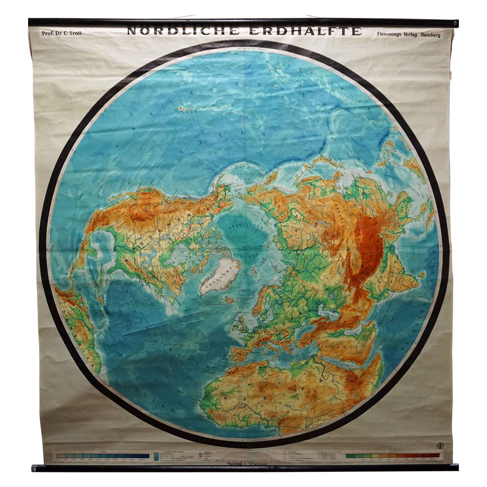
View AllNorthern Hemisphere of the Earth Rollable Map Vintage Wall Chart World Mural
Located in Berghuelen, DE
A great pull-down map or vintage wall chart illustrating the northern hemisphere of the earth. Published by Prof. Dr. C. Troll, Flemmings Verlag Ha...
Category
Mid-20th Century German Country Prints
Materials
Canvas, Wood, Paper
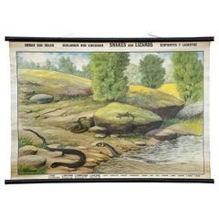
Animal Mural Vintage Rollable Wall Chart Snakes and Lizards
Located in Berghuelen, DE
The vintage pull-down wall chart depicts snakes and lizards e.g. snake, grass snake, lizard and slow worm. Description in English, Swedish and Portugu...
Category
Vintage 1970s German Country Prints
Materials
Canvas, Wood, Paper
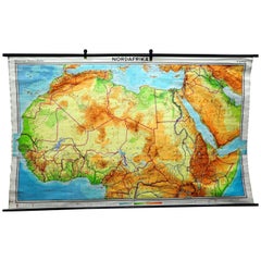
Vintage Mural Map of North Africa Countrycore African Wall Chart Decoration
Located in Berghuelen, DE
The wall map shows North Africa. It was published by Westermann-Schulwandkarten. Used as teaching material in German schools. Colorful print on paper reinforced with canvas,
Measurem...
Category
Late 20th Century German Country Prints
Materials
Canvas, Wood, Paper
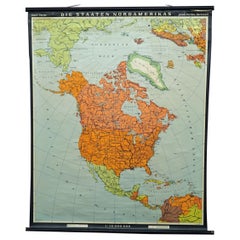
Vintage Map Wall Chart Countries of North America Rollable Mural Poster
Located in Berghuelen, DE
The vintage pull-down school map illustrates the countries / states of North America. Published by Haack-Painke Justus Perthes Darmstadt. Colorful print on paper reinforced with canv...
Category
Late 20th Century German Country Prints
Materials
Canvas, Wood, Paper
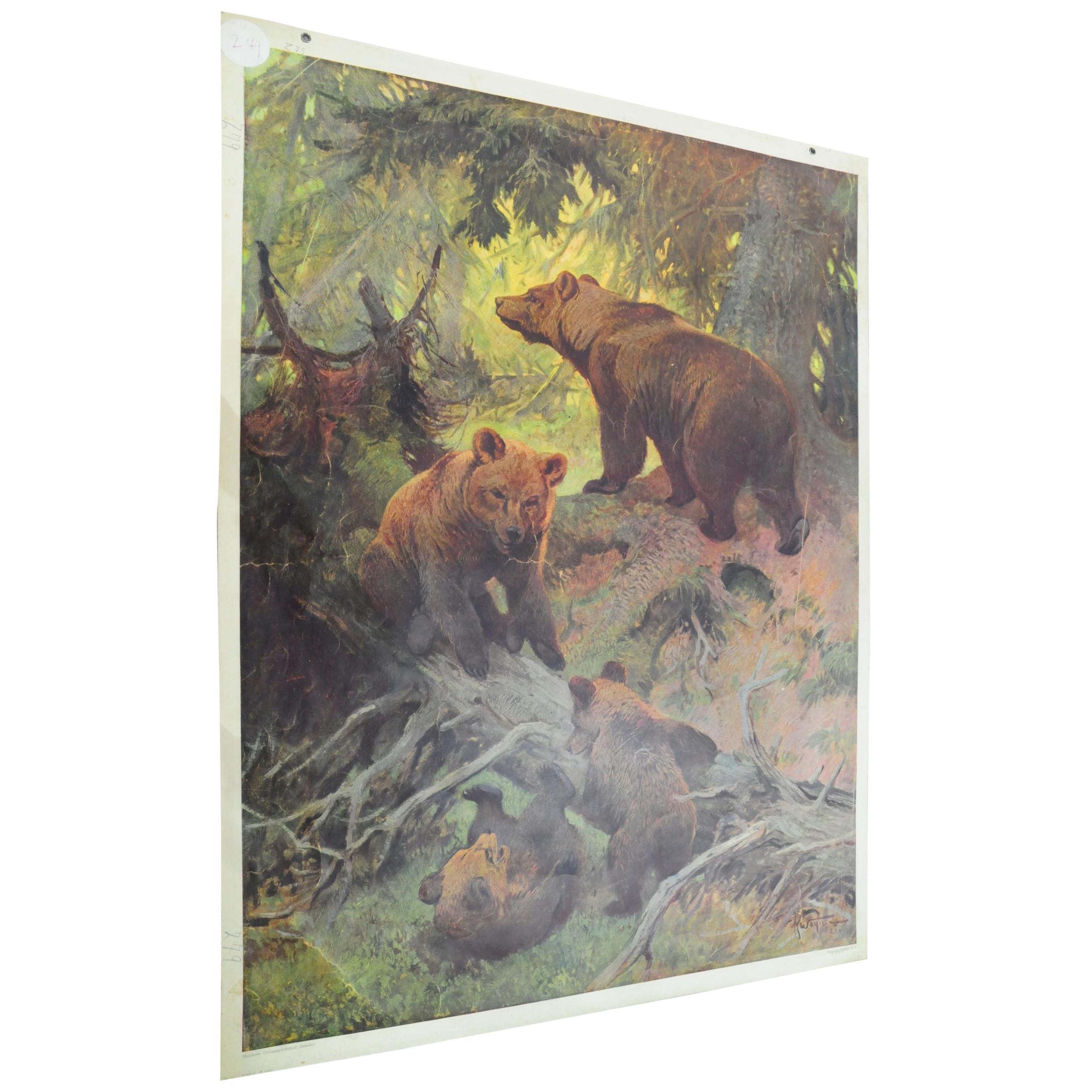
Countrycore Mural Vintage Cottagecore Printed Wall Chart Family of Brown Bears
Located in Berghuelen, DE
The old vintage-style wall shows a lovely scenery of two brown bears with two younger bears. It was published by the Meinhold Verlagsgesellschaft, Dresden. Colorful print on thick pa...
Category
Mid-20th Century German Country Prints
Materials
Paper

$224 Sale Price
30% Off
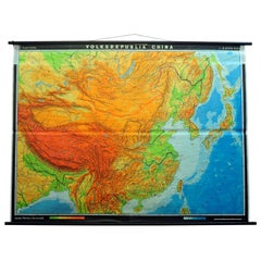
Vintage Picture Poster Wall Chart Rollable Large Map Peoples Republic of China
Located in Berghuelen, DE
A vintage wall chart illustrating a map of people's republic of china. Used as teaching material in German schools. Colorful print on paper reinforce...
Category
Late 20th Century German Country Prints
Materials
Canvas, Wood, Paper
You May Also Like
Vintage Wall Chart of Balikpapan 'Indonesia'
Located in Langweer, NL
Vintage wall chart titled 'Balikpapan'. View of Balikpapan, a seaport city in East Kalimantan, Indonesia. Published circa 1920.
The vintage wall ch...
Category
Early 20th Century Prints
Materials
Paper
$930 Sale Price
20% Off
Vintage Wall Chart of Australia, 1949
Located in Langweer, NL
Vintage wall chart of Australia and surroundings. Published by R. Bos and K. Zeeman, 1949.
Category
Mid-20th Century Prints
Materials
Paper

$697 Sale Price
25% Off
Vintage Wall Chart of a Landscape and Geographic Map, circa 1955
Located in Langweer, NL
Vintage wall chart titled 'Kaart en Landschap'. This wall chart shows a mountain range and geographic map. Published by J.B. Wolters, circa 1955.
Category
Mid-20th Century Prints
Materials
Paper

$558 Sale Price
20% Off
Vintage Anatomy Wall Chart of the Upper Body, circa 1960
Located in Langweer, NL
Vintage wall chart of the upper body. Sticker on verso reads '2008 Deutsches Hygiene Museum Dresden'. Published circa 1960.
Category
Mid-20th Century Prints
Materials
Paper

$884 Sale Price
20% Off
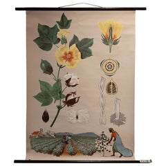
Vintage Botany Wall Chart of a Cotton Plant and Cotton Cultivation, circa 1960
Located in Langweer, NL
The vintage botany wall chart of a cotton plant and cotton cultivation by Jung, Koch, and Quentell, published around 1960, is an excellent example of educ...
Category
Mid-20th Century Prints
Materials
Paper
$1,628 Sale Price
20% Off
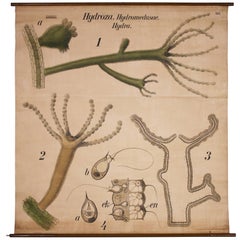
Vintage Wall Chart Lithograph Hydra by Paul Pfurtscheller for Martinus Nijhoff
Located in Oakville, CT
Antique educational wall chart lithograph - "Hydroza, Hydromedusae, Hydra" by Paul Pfurtscheller for Martinus Nijhoff. Wooden dowel measures 53" in...
Category
Early 20th Century European Prints
Materials
Wood, Paper, Linen