Items Similar to Antique Battle Scene of the Attack on Split on the Adriatic Coast
Want more images or videos?
Request additional images or videos from the seller
1 of 6
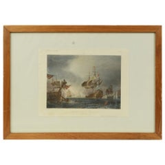
Antique Battle Scene of the Attack on Split on the Adriatic Coast
$614.65
$768.3120% Off
£451.01
£563.7620% Off
€512
€64020% Off
CA$837.51
CA$1,046.8820% Off
A$943.31
A$1,179.1420% Off
CHF 488.51
CHF 610.6420% Off
MX$11,456.19
MX$14,320.2320% Off
NOK 6,205.19
NOK 7,756.4920% Off
SEK 5,886.15
SEK 7,357.6920% Off
DKK 3,896.63
DKK 4,870.7920% Off
Shipping
Retrieving quote...The 1stDibs Promise:
Authenticity Guarantee,
Money-Back Guarantee,
24-Hour Cancellation
About the Item
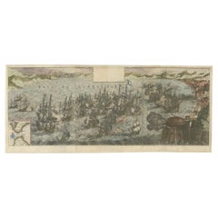
Antique print titled 'Abbildung der Statt und Vestung Sovazchi, so von den Venetianern, durch den H. G. Lazaro Mocenigo, erobert und Demolirt worden den 18. May 1657'. Great battle scene of the attack on Split on the Adriatic coast, on May 18, 1657. The bay is filled with ships shrouded in clouds of smoke and armies are shown throughout the countryside. German text explanation in banner at bottom. Published circa 1660 by M. Merian.
Mathaus Merian (1593-1650) was the father of engraver Matthäus the Younger, and of the painter, engraver, and naturalist Maria Sibylla Merian. He was born in Basel, Switzerland and trained in engraving in Zurich. After a time in Nancy, Paris and Strasbourg, he settled in Frankfurt. While there, he worked for Johann Theodor de Bry, the publisher and son of the travel writer. In 1617, he married Maria Magdalena de Bry, Johann Theodor’s daughter. In 1623, Merian took over the de Bry publishing house upon the death of his father-in-law. Merian’s best known works are detailed town views which, due to their accuracy and artistry, form a valuable record of European urban life in the first half of the sixteenth century.
- Dimensions:Height: 11.5 in (29.2 cm)Width: 12.25 in (31.1 cm)Depth: 0.02 in (0.5 mm)
- Materials and Techniques:
- Period:Mid-17th Century
- Date of Manufacture:circa 1660
- Condition:Strong toning, original folding line. Shows overall wear/creasing and soiling, blank verso. Please study image carefully.
- Seller Location:Langweer, NL
- Reference Number:Seller: BG-133801stDibs: LU3054333071662
About the Seller
5.0
Recognized Seller
These prestigious sellers are industry leaders and represent the highest echelon for item quality and design.
Platinum Seller
Premium sellers with a 4.7+ rating and 24-hour response times
Established in 2009
1stDibs seller since 2017
2,484 sales on 1stDibs
Typical response time: <1 hour
- ShippingRetrieving quote...Shipping from: Langweer, Netherlands
- Return Policy
Authenticity Guarantee
In the unlikely event there’s an issue with an item’s authenticity, contact us within 1 year for a full refund. DetailsMoney-Back Guarantee
If your item is not as described, is damaged in transit, or does not arrive, contact us within 7 days for a full refund. Details24-Hour Cancellation
You have a 24-hour grace period in which to reconsider your purchase, with no questions asked.Vetted Professional Sellers
Our world-class sellers must adhere to strict standards for service and quality, maintaining the integrity of our listings.Price-Match Guarantee
If you find that a seller listed the same item for a lower price elsewhere, we’ll match it.Trusted Global Delivery
Our best-in-class carrier network provides specialized shipping options worldwide, including custom delivery.More From This Seller
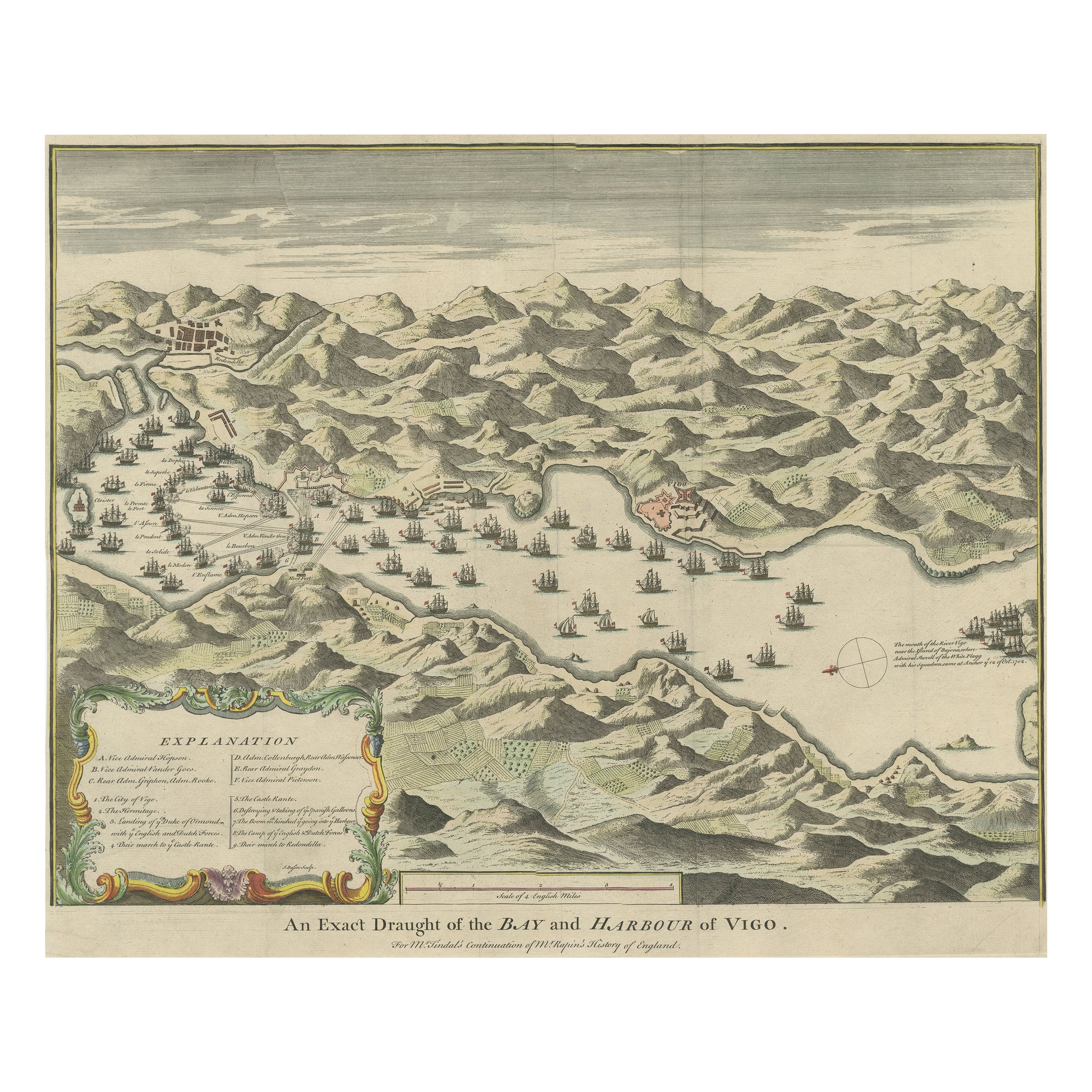
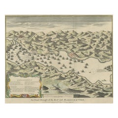
View AllAntique Print of the Battle in 1702 of Vigo Bay or Rande, Galicia, Spain
Located in Langweer, NL
Antique print titled 'An Exact Draught of the Bay and Harbour of Vigo'. The Battle of Vigo Bay was an engagement that saw a combined Dutch/English naval force successfully capture on...
Category
Antique Mid-18th Century Prints
Materials
Paper
$845 Sale Price
20% Off
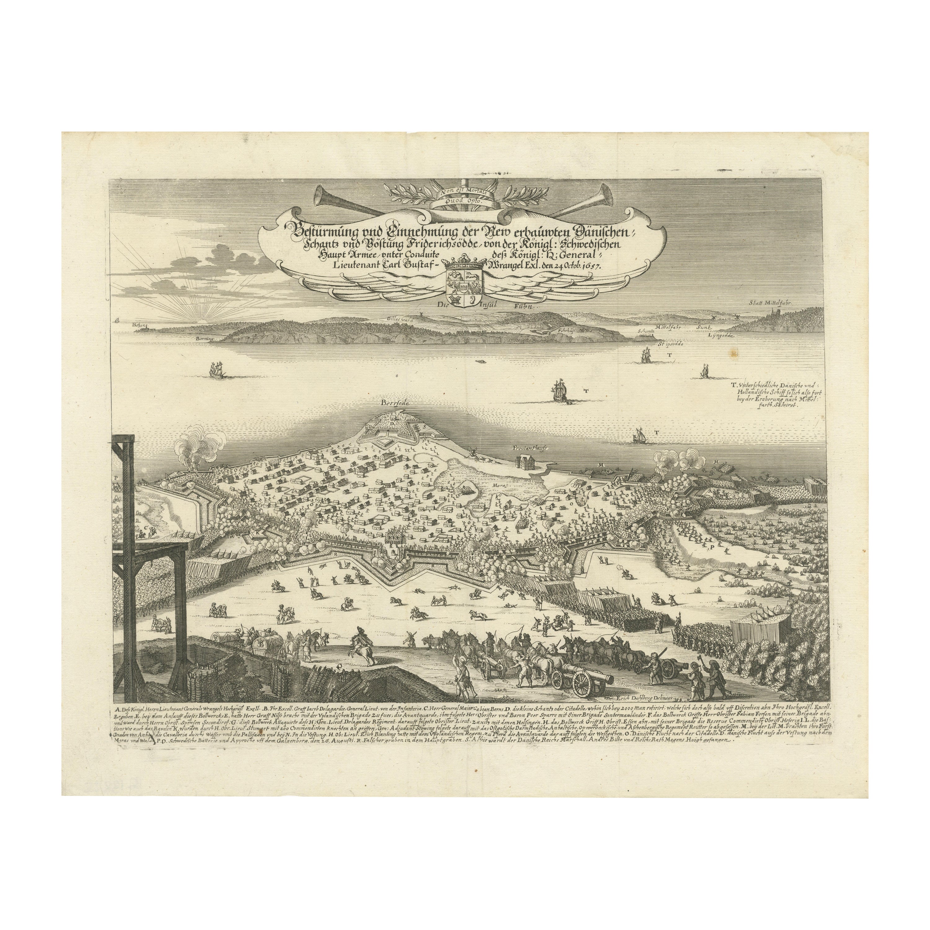
Prince Henry's Naval and Land Battle during the Seven Years' War Engraved, 1667
Located in Langweer, NL
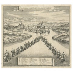
The engraving depicts the assault and capture of the Danish fortress Friderichsodde (now known as Fredericia) located on the island of Fyn. The scene, captured on October 24, 1657, vividly illustrates the Swedish main army's takeover under the command of General Carl Gustaf Wrangel. This historical event is meticulously documented in the artwork, which showcases not only the military action but also the strategic landscape and fortifications characteristic of the time.
Erik Jönsson Graf von Dahlberg, the artist behind this work, was a prominent Swedish field marshal, architect, and fortress builder. Born in 1625 and passing in 1703, Dahlberg's contributions to military and architectural fields were significant. He was renowned for his detailed and artistically valuable drawings which served as the basis for large-scale copperplate engravings. These engravings are of substantial topographical and architectural historical importance as they provide a detailed visual account of Swedish territories during the era.
In 1661, Dahlberg began work on his magnum opus—a comprehensive geographical and historical depiction of Swedish territories, which received royal privileges. His journey in 1667-1668 to Paris for the engraving of the initial plates reflects the international scope and ambition of his project. However, the work was intermittently paused when Dahlberg was tasked in 1674 with overseeing all Swedish fortress constructions, a role that significantly impacted his career and works. The project resumed and was published in 1684, highlighting a significant period of Swedish history and military achievements under his visual documentation.
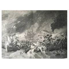
MORE ABOUT THE BATTLE:
The image is an intricate engraving depicting a battle scene. Based on the details and the text in the cartouche, the scene illustrates a significant historical battle involving Prussian forces. The presence of multiple ships and extensive fortifications suggests a combined land and naval engagement.
Key Features in the Engraving:
1. Land Battle: The forefront of the image shows numerous troops, artillery pieces, and cavalry in action, depicting the intensity and scale of the land combat.
2. Naval Elements: Ships in the background indicate that this battle had a naval component, which would have been crucial for controlling trade routes or strategic waterways.
3. Fortifications: Extensive fortifications, including bastions and protective walls, suggest a well-defended location, possibly a city or a significant stronghold.
Historical Context:
From the text, it appears the battle involves "Prinz Heinrich," referring to Prince Henry of Prussia, who was an influential military leader during the reign of his brother, Frederick the Great. Under Frederick’s rule, Prussia engaged in several key conflicts, including the Seven Years' War (1756-1763), which saw major battles across Europe and involved complex alliances.
Given the level of detail and the era suggested by the style of ships and fortifications, the battle was of the significant engagements during the Seven Years' War, where Prince Henry played a critical role. His campaigns often involved maneuvering to protect Prussia from multiple fronts, including naval engagements in the Baltic.
Interpretation:
This engraving serves not only as a historical document but also as a piece of propaganda, likely glorifying the prowess and strategic capabilities of the Prussian military...
Category
Antique 1670s Prints
Materials
Paper
$441 Sale Price
20% Off
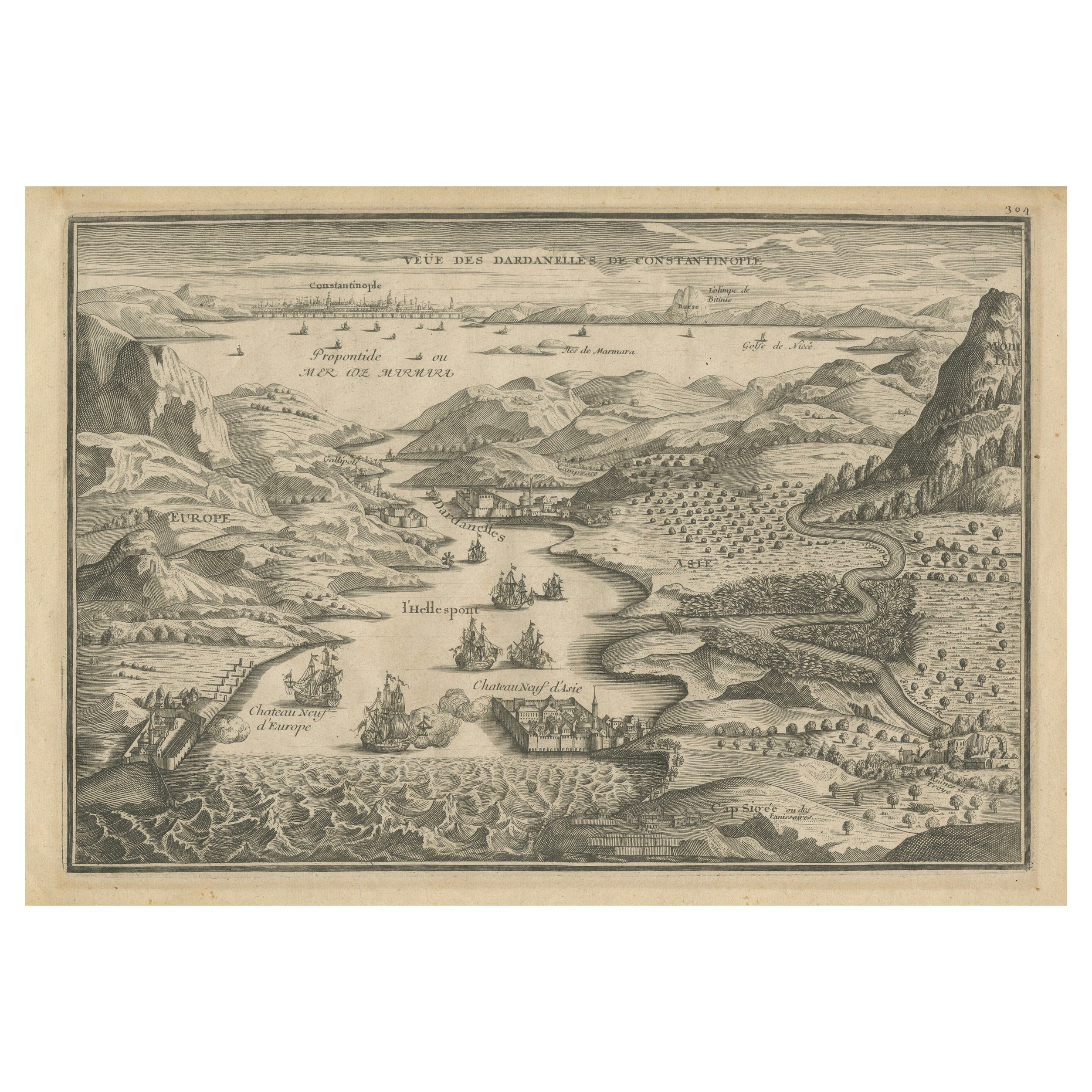
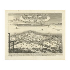
Dardanelles Strait, with a Perspective of the City of Constantinople, 1693
Located in Langweer, NL
Title: "Veue des Dardanelles de Constantinople, 1693"
Description: This historical copper engraving, crafted by Nicholas de Fer between 1646 and 1720 in Paris, is a remarkable depic...
Category
Antique 1690s Prints
Materials
Paper

$326 Sale Price
20% Off
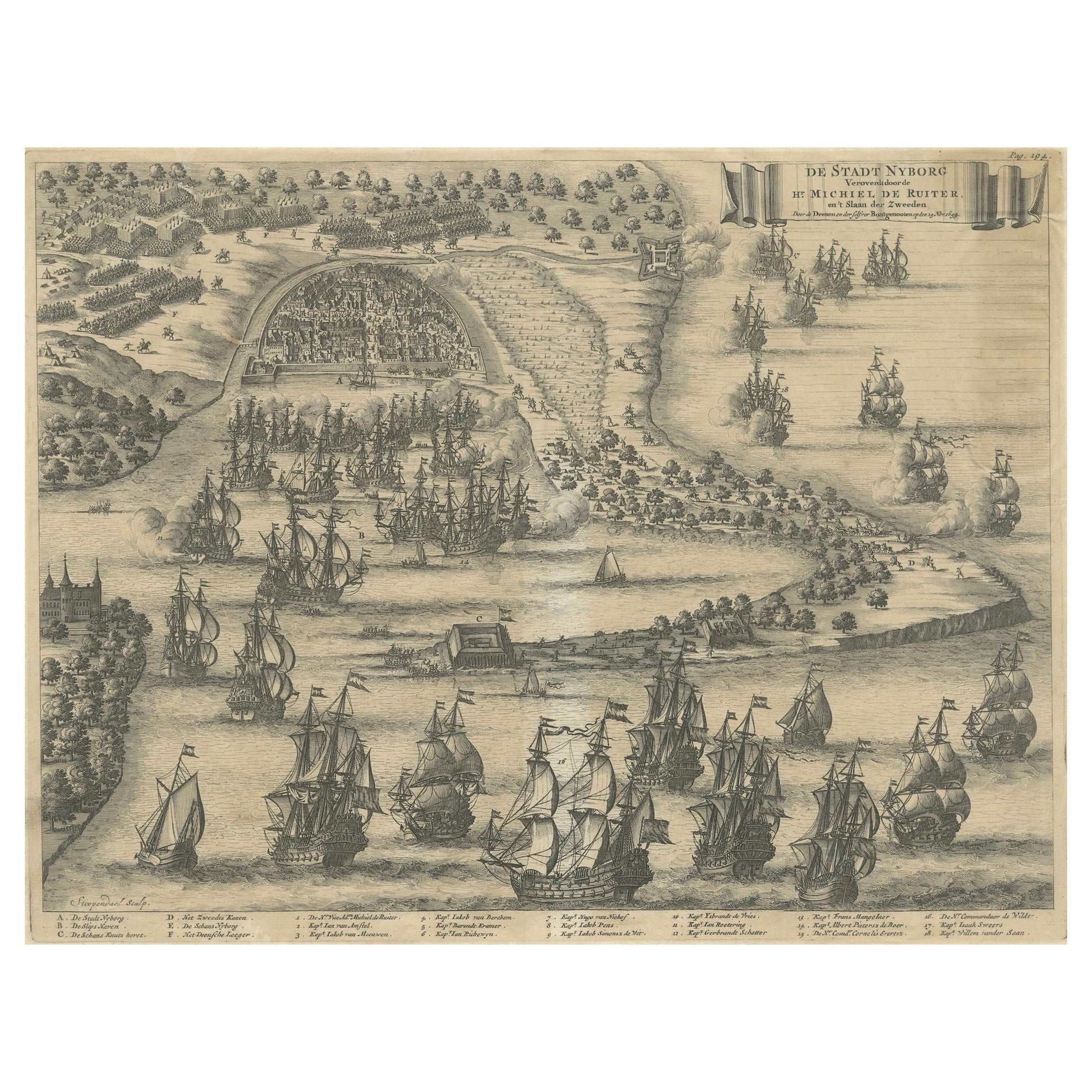
The Siege of Nyborg, 1659: A Strategic Battle of the Dano-Swedish War, 1746
Located in Langweer, NL
Title: "The Siege of Nyborg, 1659: A Strategic Battle of the Dano-Swedish War"
Translated text (From Dutch) on copper engraving: "The city of Nyborg captured by the lord Michiel de ...
Category
Antique 1740s Prints
Materials
Paper

$211 Sale Price
20% Off
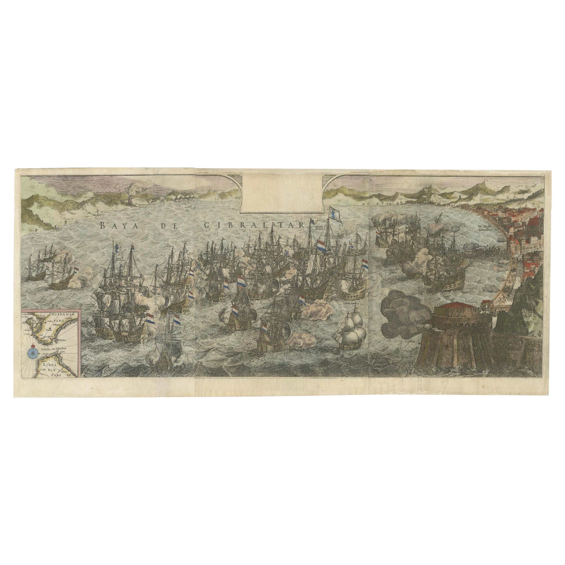
Rare Large 1650 Copper Engraving Depicting the Naval Battle of Gibraltar, 1607
Located in Langweer, NL
Title: Rare Large 1650 Copper Engraving Depicting the Naval Battle of Gibraltar, 1607
Description: This rare and exceptionally large copper engraving, measuring 32 x 85 cm, capture...
Category
Antique 1650s Prints
Materials
Paper
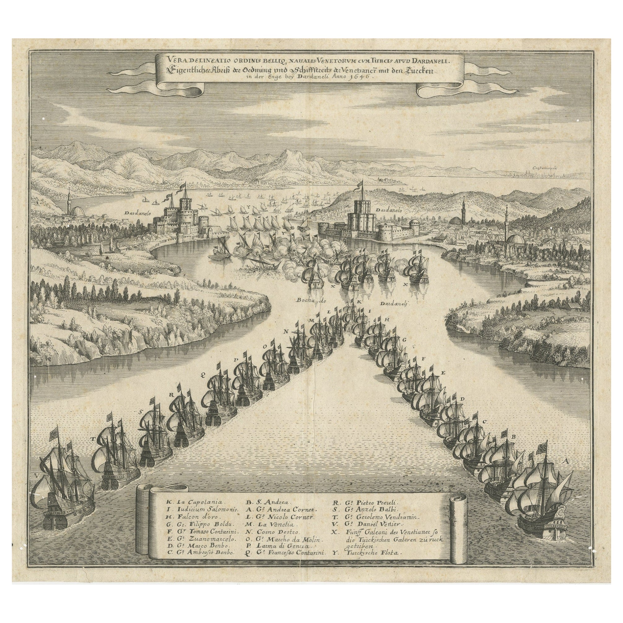
Copper Engraving by Merian of The Battle Fleet off Constantinople, 1646
Located in Langweer, NL
An engraving by Matthäus Merian senior depicting the "Sea battle of the Venetians against the Turks in the Dardanelles" from 1646 . It presents a dramatic and detailed scene capturi...
Category
Antique 1640s Prints
Materials
Paper
$441 Sale Price
20% Off
You May Also Like
B.West Engraving "Naval Battle, Battle of the Houge" 18th Century
Located in Beuzevillette, FR
This magnificent engraving is entitled "Battle of La Hougue" by the engraver E.C Voysard after Benjamin West.
It depicts the Battle of Barfleur- La Hougue,...
Category
Antique 18th Century French Prints
Materials
Paper
Battles of Montebello and Casteggio in Antique Frame
Located in Alessandria, Piemonte
Antique French print of Battles of Montebello and Casteggio in antique frame. Under the print there is the whole description in French language.
"Painted by Naudet - Lebeau sculpsit ...
Category
Antique Early 19th Century French Neoclassical Prints
Materials
Fruitwood, Paper
18th Century French Map and City View of Joppe/Jaffa (Tel Aviv) by Sanson
By Nicholas Sanson d'Abbeville
Located in Alamo, CA
An original antique engraving entitled "Joppe; in ’t Hebreeusch by ouds Japho; hedendaags Japha, of Jaffa; volgens d’aftekening gedaan 1668", by Nicholas Sanson d'Abbeville (1600 - 1667). This is a view of the city of Joppe (in Hebrew Japho), now called Japha or Jaffa, the harbor portion of modern day Tel Aviv, Israel as it appeared in 1668 . It depicts a very busy harbor with numerous boats. A large ship on the left appears to be firing its canons and a small ship on the right appears to be sitting very low in the water, either heavily loaded with cargo or sinking. The town is seen on the far shore with a fortress on a hill across in the background. The map is printed from the original Sanson copperplate and was published in 1709 by his descendants.
The map is presented in an ornate brown wood frame embellished by gold-colored leaves and gold inner trim with a double mat; the outer mat is cream-colored and the inner mat is black. There is a central vertical fold, as issued. There are two small spots in the lower margin and one in the upper margin, as well as two tiny spots adjacent to the central fold. 1717 is written below the date 1668 in the inscription. The map is otherwise in very good condition.
Another map of the "Holy Land" (by Claes Visscher in 1663), with an identical style frame and mat is available. This pair of maps would make a wonderful display grouping. Please see Reference #LU117324709892.
Artist: Nicholas Sanson d'Abbeville (1600 - 1667) and his descendents were important French cartographer's active through the 17th century. Sanson started his career as a historian and initially utilized cartography to illustrate his historical treatises. His maps came to the attention of Cardinal Richelieu and then King Louis XIII of France, who became a supporter and sponsor. He subsequently appointed Sanson 'Geographe Ordinaire du Roi' the official map maker to the king. Sanson not only created maps for the king, but advised him on geographical issues and curated his map collection...
Category
Early 1700s Prints and Multiples
Materials
Engraving

1900s Vintage Lithographic Print of the Naval Battle of Beziers, Oak Wood Frame
Located in Milan, IT
Lithographic print of the Naval Battle of Beziers on 10th July 1690, taken from the book Historical Gallery of Versailles 319bis. Skelton is the engraver. Original print by Victor Gilbert Théodore Gudin...
Category
Early 20th Century French Nautical Objects
Materials
Paper
Naval Battle Engagement at Sea Large Busy Battle Scene Many Ships, Signed Oil
Located in Cirencester, Gloucestershire
English School, early 20th century
signed
oil painting on canvas, unframed
canvas: 17 x 24 inches
provenance: private collection, Eng;and
condition: good and sound condition, minor ...
Category
Early 20th Century Old Masters Landscape Paintings
Materials
Oil, Canvas
$1,362 Sale Price
30% Off
Daniel Marot's The Siege of the Dutch Fortified City of Ypres by Louis XIV
By Daniel Marot
Located in Alamo, CA
"Ypres, Grand Ville Riche & Marchande" is an engraving and etching by Daniel Marot (le Vieux) (1661–1752). It depicts a view of the siege of the city of Ypres and its citadel on the left in the Spanish Netherlands by Louis XIV's troops. This battle took place between March 18 and March 25, 1678, as part of the Franco-Dutch War. Marot illustrated in great detail (best appreciated with magnification) the French attack on the strong pentagonal citadel on the extreme left, which had been built recently in anticipation of a French attack. The trenches built by the French approaching the town are seen on the right. King Louis XIV can be seen in the foreground surveying the battle mounted on his white horse, surrounded by his officers and troops.
The print is presented in an attractive ornate black wood frame with a cream-colored double mat with a black inner trim. It is glazed with plexiglas. The frame measures 25.38" x 22.63" x .88". The engraving, frame, mat and glazing are in excellent condition.
Artist: Daniel Marot (1661–1752) was also called "Le Vieux". He was the son of the famous architect, Jean Marot. Marot had diverse interests and talents. In addition to his art, he designed garden projects, architectural ornaments, furniture, and even upholstery. Marot as a Huguenot protestant was forced to leave France in 1685 following the revocation of the Edict of Nantes. He emigrated to Holland, where he worked for William of Orange (an arch enemy of his former employer Louis XIV). Marot was largely responsible for the interiors of Williams palace at the Loo. In 1694 he went Britain as William had married Queen Mary and he had become King William III of England. He later returned to Holland in about 1698 and died in the Hague in 1752. He left a lasting legacy on the decorative arts in the Netherlands, where his grand version of the Louis XIV style remained popular into the 1730s.
Historical Background: In October 1677, Mary Stuart, niece and possible successor of Charles II of England, married Louis XIV's arch enemy William III of Orange...
Category
Late 17th Century Old Masters Landscape Prints
Materials
Engraving, Etching
More Ways To Browse
Battle Scene
Vintage Bone Rings
Vintage Cooking Photos
Vintage Crystal Display Cabinet
Vintage Embroidered Tablecloth
Vintage Film Reel
Vintage Gas Signs
Vintage Glass Jar Lids
Vintage Round Outdoor Dining Table
Vintage Suitcase Table
Vintage Teak Buffet
Vintage Theatre Spotlight
Vintage Venetian Masks
Vintage Wine Corkscrew
Vintage Wood Canoes
Wheeler Sight Light
Wiener Werkstatte Glazed
William And Mary Oyster Veneer