Items Similar to Antique Print of Franeker, Friesland, the Netherlands by Guicciardini, 1616
Want more images or videos?
Request additional images or videos from the seller
1 of 6
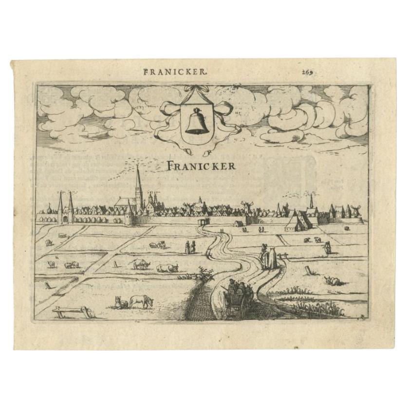
Antique Print of Franeker, Friesland, the Netherlands by Guicciardini, 1616
$105.89
$132.3720% Off
£78.40
£9820% Off
€88
€11020% Off
CA$146.62
CA$183.2720% Off
A$160.07
A$200.0920% Off
CHF 83.92
CHF 104.9020% Off
MX$1,944.14
MX$2,430.1720% Off
NOK 1,048.02
NOK 1,310.0220% Off
SEK 989.61
SEK 1,237.0120% Off
DKK 669.96
DKK 837.4520% Off
About the Item
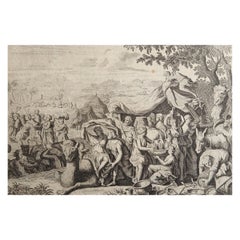
Antique print titled 'Franicker'. View of the city of Franeker, Friesland, the Netherlands. This print originates from 'Omnium Belgii sive Inferioris Germaniae (..)' by L. Guicciardini.
Artists and Engravers: Lodovico Guicciardini (1521-1589), Italian merchant from aristocratic descent. He was born in Florence, a son of Jacopo Guicciardini. His uncle was the famous author Francesco Guicciardini (1483-1540) who wrote 'La historia di Italia'. The Guicciardini family established a presence in Antwerp and in 1541 Lodovico arrived to work with his uncle. At the same time they functioned as informents for the Medici's back home. He stayed until his death. At one point he was accused with his brother Giovan Battista of killing Gaspare Ducci, who they held resposible for their bancruptcy in 1543. Lodovico apparently started writing in 1552 and in 1556 he published his first work 'Comentarii della......', about European history. In 1567 he got the 'Descrittione....' published. He wrote a few more works. In 1569 he landed in jail because he critisized Alva's policies. In 1582 he landed in jail again because he apparently knew Jean Jaureguy, who tried to kill William of Orange, but he was released soon. Although he had been prosperous at times he ended a poor man. Plates engraved by the very skilled Pieter van den Keere or Petrus Kaerius (1571-1646), a Flemish engraver, publisher and globe maker.
Condition: Fair/good, age-related toning. Shows some wear. Latin text on verso, please study image carefully.
Date: 1616
Overall size: 23.5 x 15.5 cm.
Image size: 19.5 x 14 cm.
We sell original antique maps to collectors, historians, educators and interior decorators all over the world. Our collection includes a wide range of authentic antique maps from the 16th to the 20th centuries. Buying and collecting antique maps is a tradition that goes back hundreds of years. Antique maps have proved a richly rewarding investment over the past decade, thanks to a growing appreciation of their unique historical appeal. Today the decorative qualities of antique maps are widely recognized by interior designers who appreciate their beauty and design flexibility. Depending on the individual map, presentation, and context, a rare or antique map can be modern, traditional, abstract, figurative, serious or whimsical. We offer a wide range of authentic antique maps for any budget.
- Dimensions:Height: 6.11 in (15.5 cm)Width: 9.26 in (23.5 cm)Depth: 0 in (0.01 mm)
- Materials and Techniques:
- Period:
- Date of Manufacture:1616
- Condition:Condition: Fair/good, age-related toning. Shows some wear. Latin text on verso, please study image carefully.
- Seller Location:Langweer, NL
- Reference Number:Seller: BG-119441stDibs: LU3054329586762
About the Seller
5.0
Recognized Seller
These prestigious sellers are industry leaders and represent the highest echelon for item quality and design.
Platinum Seller
Premium sellers with a 4.7+ rating and 24-hour response times
Established in 2009
1stDibs seller since 2017
2,641 sales on 1stDibs
Typical response time: <1 hour
- ShippingRetrieving quote...Shipping from: Langweer, Netherlands
- Return Policy
Authenticity Guarantee
In the unlikely event there’s an issue with an item’s authenticity, contact us within 1 year for a full refund. DetailsMoney-Back Guarantee
If your item is not as described, is damaged in transit, or does not arrive, contact us within 7 days for a full refund. Details24-Hour Cancellation
You have a 24-hour grace period in which to reconsider your purchase, with no questions asked.Vetted Professional Sellers
Our world-class sellers must adhere to strict standards for service and quality, maintaining the integrity of our listings.Price-Match Guarantee
If you find that a seller listed the same item for a lower price elsewhere, we’ll match it.Trusted Global Delivery
Our best-in-class carrier network provides specialized shipping options worldwide, including custom delivery.More From This Seller
View AllAntique Print of Franeker, City in Friesland, the Netherlands, 1613
Located in Langweer, NL
Antique print titled 'Franicker'. View of the city of Franeker, Friesland, the Netherlands. This print originates from the scarse French edition of 'Description de touts les Pays-Bas...
Category
Antique 17th Century Prints
Materials
Paper
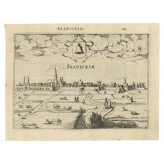
$259 Sale Price
20% Off
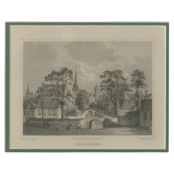
Antique Print of Franeker, Friesland, The Netherlands, 'c.1860'
Located in Langweer, NL
Antique print titled 'Franeker'. View of the city hall of Franeker, Friesland, the Netherlands. This print originates from 'Het Koningrijk der Nederlanden voorgesteld in eene reeks v...
Category
Antique 19th Century Prints
Materials
Paper
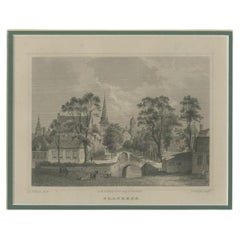
$259 Sale Price
20% Off
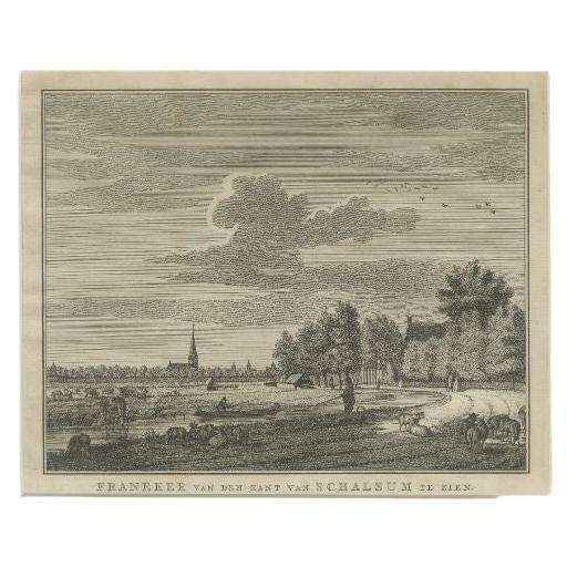
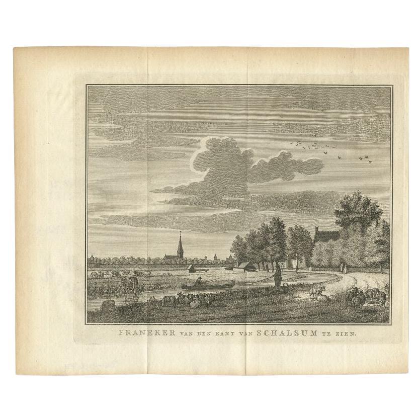
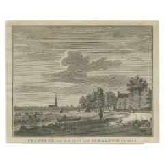
Antique Print of the Old University Town Franeker in the Netherlands '1786'
Located in Langweer, NL
Antique print titled 'Franeker van den kant van Schalsum te zien'. Old print with a view on the city of Franeker, as seen from Schalsum. This print originates from 'Hedendaagsche His...
Category
Antique 18th Century Dutch Prints
Materials
Paper
$259 Sale Price
20% Off
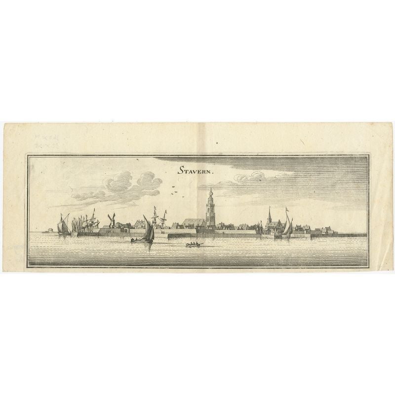
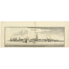
Antique Print of the City of Stavoren, Friesland, the Netherland by Merian, 1659
Located in Langweer, NL
Antique print titled 'Stavern'. Panoramic view of the city of Stavoren, Friesland. This print originates from 'Topographia Germaniae Inferioris'.
Artists and Engravers: Matthaus M...
Category
Antique 17th Century Prints
Materials
Paper
$211 Sale Price
20% Off
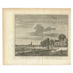
Antique Print of Franeker in Friesland, the Netherlands, '1786'
Located in Langweer, NL
Antique print titled 'Franeker van den kant van Schalsum te zien'. Old print with a view on the city of Franeker, as seen from Schalsum. This print originates from 'Hedendaagsche His...
Category
Antique 18th Century Prints
Materials
Paper
$134 Sale Price
20% Off
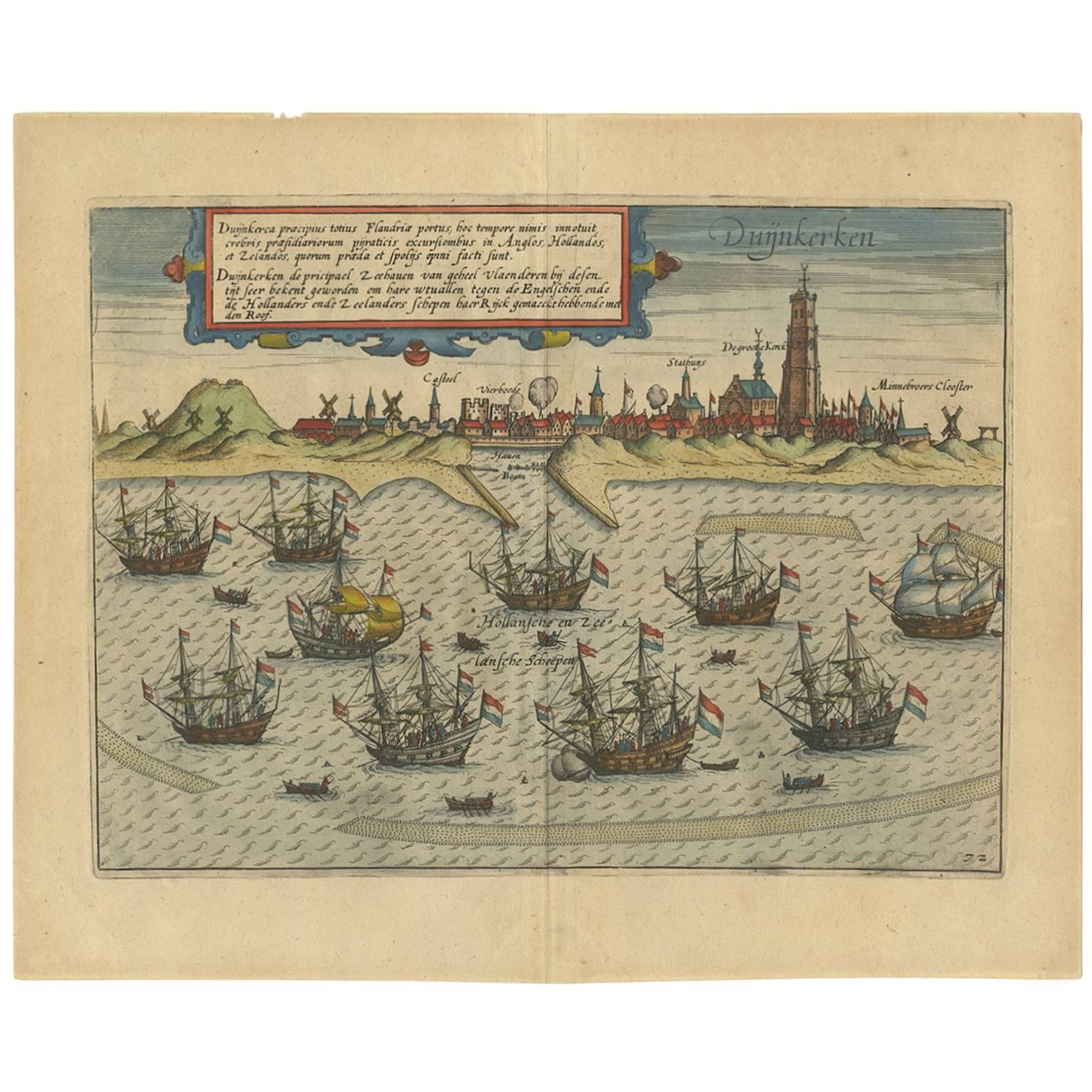
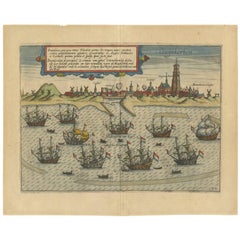
Antique Print of the Town of Duinkerken ‘France’ by L. Guicciardini, 1613
Located in Langweer, NL
Beautiful bird's eye-view plan of the town of Duinkerken. From Ludovico Guicciardini.'s description of the Netherlands 'Beschrijvinghe van alle de Nederlanden anderssins ghenoemt Ned...
Category
Antique Early 17th Century Prints
Materials
Paper
$543 Sale Price
20% Off
You May Also Like
17th Century Topographical Engraving Nantes & St. Malo, France, by Iohan Peeters
Located in New York, NY
The ancient city of Saint Malo in North Western France has long been associated with adventure on the high seas, piracy and exploration. It was the birthplace of several important in...
Category
Antique 17th Century Dutch Maps
Materials
Paper

Map of Kampen, Netherlands - by G. Braun and F. Hogenberg - Late 16th Century
By Franz Hogenberg
Located in Roma, IT
This map of Kampen (the ancient Campensis) is an original etching realized by George Braun and Franz Hogenberg as part of the famous Series "Civitates Orbis Terrarum".
The “Civita...
Category
16th Century Figurative Prints
Materials
Etching

Map of Antwerp - Etching by G.Braun and F. Hogenberg -Late 16th century
By Franz Hogenberg
Located in Roma, IT
This Map of Anverpia is an original etching hand colored realized by George Braun and Franz Hogenberg as part of the famous Atlas "Civitates Orbis Ter...
Category
16th Century Old Masters Figurative Prints
Materials
Etching

Map of Dordrecht - Etching by G. Braun/F. Hogenberg - Late 16th Century
Located in Roma, IT
Map od Dordrecht is an artwork realized by Braun and Hogemberg in the late 16th century.
Hand watercolored etching.
40x54 cm.
Good conditions.
Braun Hoghemberg (1541-1622) was a ...
Category
16th Century Old Masters Figurative Prints
Materials
Etching

Original Antique Print After Jan Luyken, Amsterdam, Genesis XXXI, 1724
Located in St Annes, Lancashire
Wonderful copper-plate engraving after Jan Luyken
Published by Marten Schagen, Amsterdam. 1724
Text on verso
The measurement given is the paper size.
Category
Antique 1720s Dutch Renaissance Prints
Materials
Paper
Map of Groningen - Etching by George Braun - Late 16th Century
Located in Roma, IT
This map of Groninga is an original etching realized by George Braun and Franz Hogenberg, and part of the series "Civitates Orbis Terrarum".
The state of preservation of the artwork...
Category
16th Century Figurative Prints
Materials
Etching

More Ways To Browse
Sword Guard
The President Furniture
Thomas Taylor
Tiger Print Fabric
Tobacco Pot
Torquato Tasso
Usa Stoneware
Used Corian
Used Ethan Allen
Used Hospitality Furniture
Victorian 8 Day Mantel Clock
Victorian Cupid
View In Room
Vintage Childrens Chairs
Vintage Glass Grapes
Vintage Gracie
Vintage Italy Calendar
Vintage Martial Arts