Items Similar to Dutch Infantry Fighting Against the British Army in the Dunes in 1799

Want more images or videos?
Request additional images or videos from the seller
1 of 5
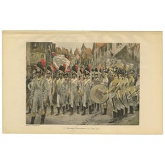
Dutch Infantry Fighting Against the British Army in the Dunes in 1799
About the Item
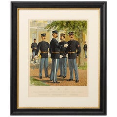
Antique print, titled: '5e Halve Brigade Infanterie en 1e Bataljon Jagers 1799.' - This plate shows the fighting of the Dutch infantry against the British army in the dunes of the province of Noord-Holland, The Netherlands, 1799. From ´De uniformen van de Nederlansche Zee- en Landmacht hier te lande en in de kolonien, naar aquarellen of teekeningen van J. Hoynck van Papendrecht, W.C. Staring en J.P. de Veer´. Published in The Netherlands 1900.
Artists and Engravers: Made by 'P. W. van de Weyer' after 'J. Hoynck van Papendrecht'. Jan Hoynck van Papendrecht (1858 - 1933) was a Dutch painter and illustrator, famed for his military art. In 1900, the famous book The Uniforms of the Dutch Navy and Army appeared in two parts, in which many of the illustrations were contributed by van Papendrecht.
Technic: Chromolithograph on vellin (wove) paper.
Condition: Good, given age. Edges slightly browned, not affecting image. Tiny tear right edge. General age-related toning and/or occasional minor defects from handling. Please study scan carefully.
Date: 1900
Overall size: 19.1 x 12.2 inch
Image size: 0.001 x 14.1 x 10.6 inch
We also offer thousands of antique prints covering fields of interest as diverse as architecture, natural history, religion, ethnology and many more. Antique prints have long been appreciated for both their aesthetic and investment value. They were the product of engraved, etched or lithographed plates. These plates were handmade out of wood or metal, which required an incredible level of skill, patience and craftsmanship. Whether you have a house with Victorian furniture or more contemporary decor an old engraving can enhance your living space.
- Dimensions:Height: 12.2 in (30.99 cm)Width: 19.1 in (48.52 cm)Depth: 0.001 in (0.03 mm)
- Materials and Techniques:
- Period:
- Date of Manufacture:1900
- Condition:
- Seller Location:Langweer, NL
- Reference Number:
About the Seller
5.0
Platinum Seller
These expertly vetted sellers are 1stDibs' most experienced sellers and are rated highest by our customers.
Established in 2009
1stDibs seller since 2017
1,916 sales on 1stDibs
Typical response time: <1 hour
- ShippingRetrieving quote...Ships From: Langweer, Netherlands
- Return PolicyA return for this item may be initiated within 14 days of delivery.
More From This SellerView All
- Infantry Battalion of the Dutch Army in 1807, Published in 1900Located in Langweer, NLAntique print, titled: '7e Regiment Infanterie van Linie, 1807.' - This plate shows the 7th Line Infantry Battalion of the Dutch army in 1807. From ´De uniformen van de Nederlansche ...Category
20th Century Prints
MaterialsPaper
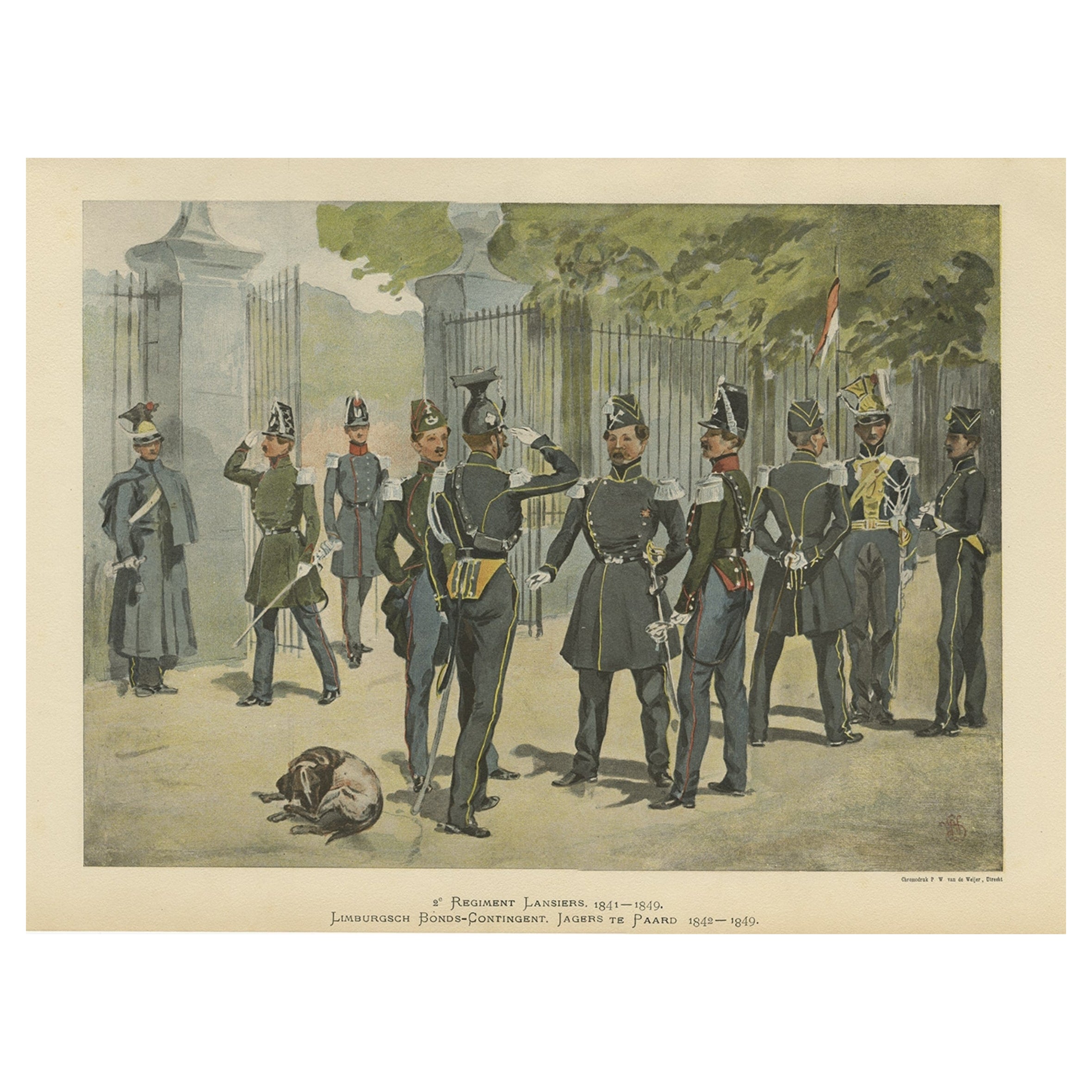
- The Cavalry of the Dutch-Belgian Army 1841-1849, Published in 1900Located in Langweer, NLAntique print, titled: '2e Regiment Lansiers 1841-1849. Limburgsch Bonds-Contingent. Jagers te paard 1842-1849.' - This plate shows the 2nd. Regiment Lanciers (Cavalry) of the Dutch/Belgian army...Category
20th Century Prints
MaterialsPaper
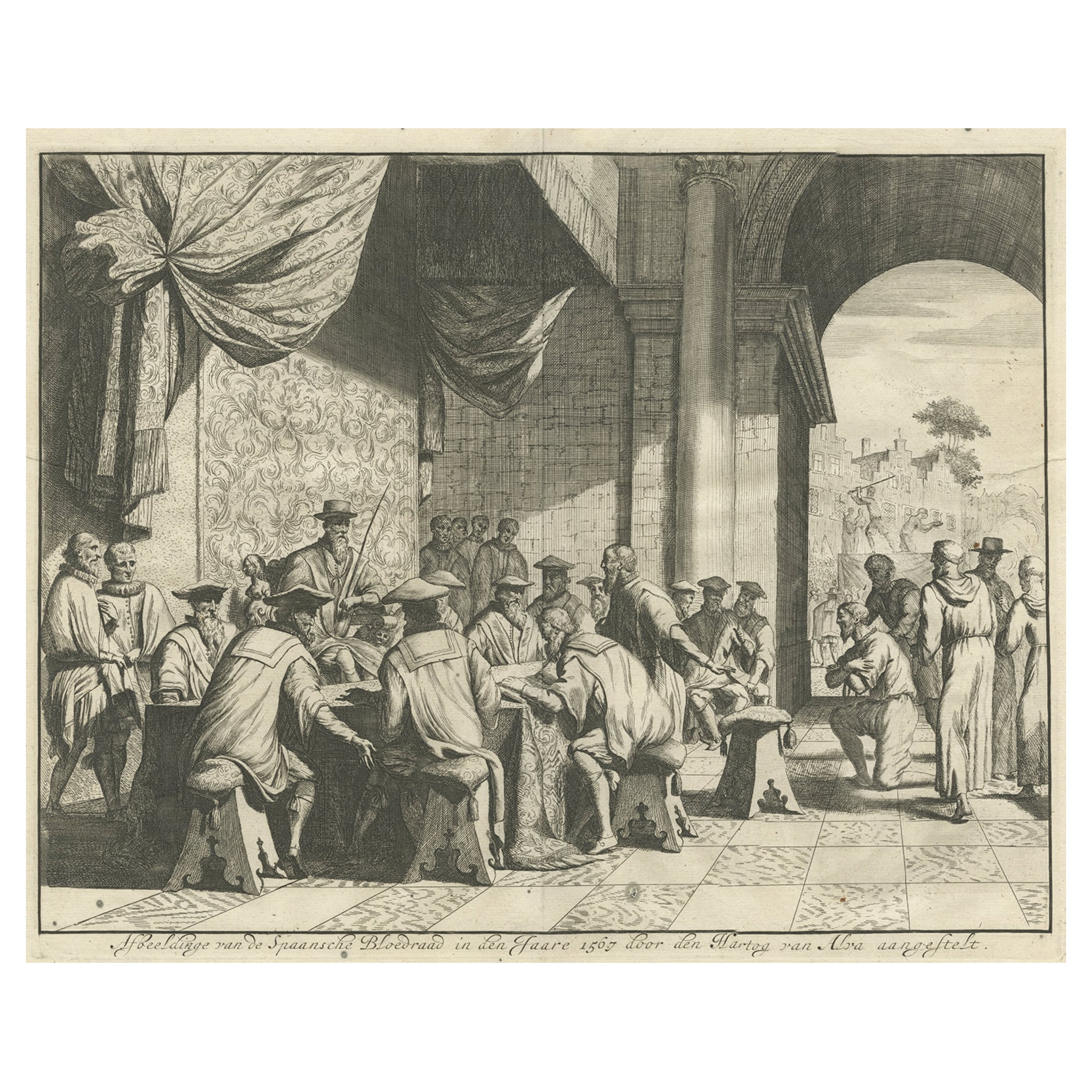
- The Iron Duke of Alva of Spain Planning the Atrocities Against the Dutch, c.1680Located in Langweer, NLAntique print titled ‘Afbeeldinge van de Spaansche Bloedraad in den Jaare 1567 door den Hartog van Alva aangestelt’. The Duke of Alva and his entourage seated at a table planning...Category
Antique 1680s Prints
MaterialsPaper
- Antique Print of Generals of the Dutch/Belgian Army 1855-1860, Published in 1900Located in Langweer, NLAntique print, titled: 'Generaal. Generale Staf 1855-1860.' - This plate shows Generals of the Dutch/Belgian army 1855-1860. From ´De uniformen van de Nederlansche Zee- en Landmacht hier te lande en in de kolonien, naar aquarellen of teekeningen van J. Hoynck van Papendrecht, W.C. Staring en J.P. de Veer´. Published in The Netherlands 1900. Artists and Engravers: Made by 'P. W. van de Weyer' after 'J. Hoynck van Papendrecht'. Jan Hoynck van Papendrecht (1858 - 1933) was a Dutch painter and illustrator, famed for his military art. In 1900, the famous book The Uniforms of the Dutch Navy...Category
Antique Early 1900s Prints
MaterialsPaper
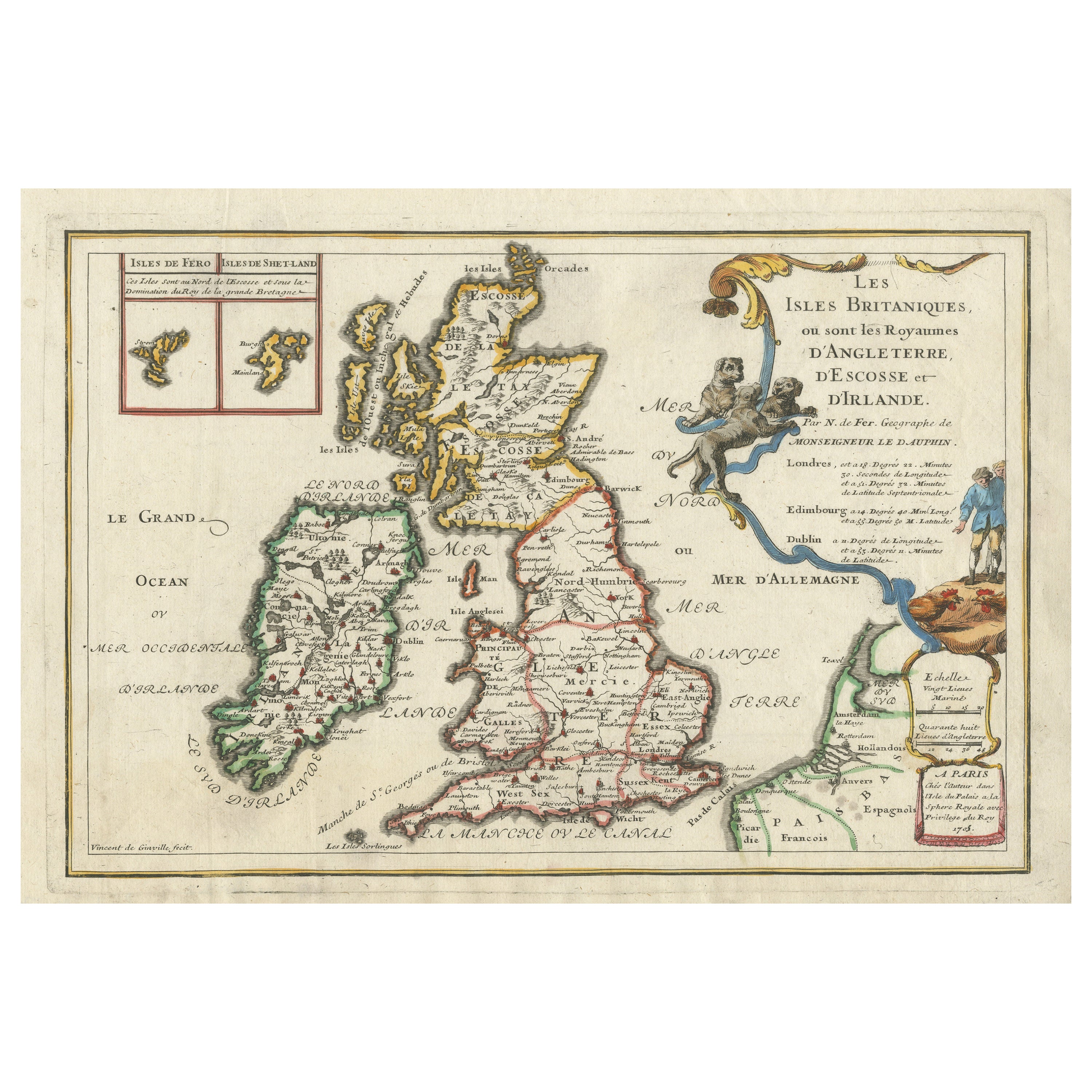
- Old Map of the British Isles with the Faroes and Shetlands, Showing Cock FightsLocated in Langweer, NLAntique map titled 'Les Isles Britaniques ou sont les Royaumes d'Angleterre (..)'. Original old map of the British Isles with inset maps of the Faroes and Shetlands. The title cartouche depicts dog...Category
Antique Early 18th Century Maps
MaterialsPaper
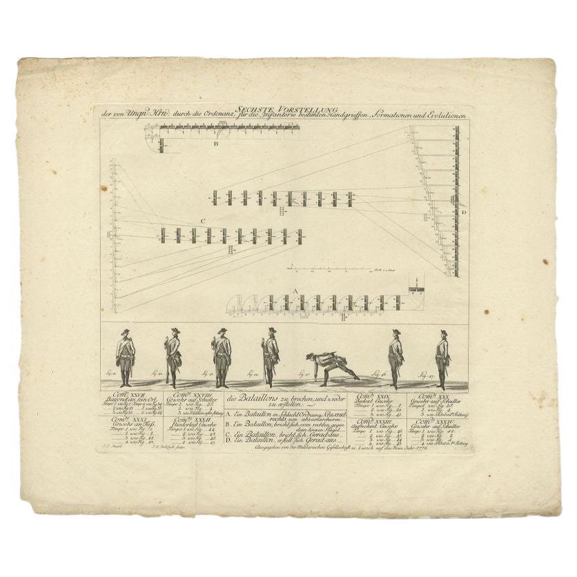
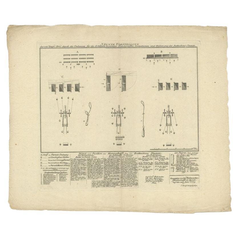
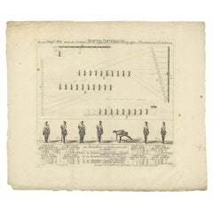
- Antique Military Print of Infantry Warfare and Infantry Training, 1773Located in Langweer, NLAntique print titled 'Sechste Vorstellung'. Old military print published by 'Militarischen Gesellschaft in Zurich'. This society published a series of prints mainly dealing with the ...Category
Antique 18th Century Prints
MaterialsPaper


You May Also Like
- 1908 Artillery & Musician Infantry Uniforms by Ogden, Antique ChromolithographLocated in Colorado Springs, COThis colorful lithograph by H. A. Ogden was published in 1908 by Brigadier General J. B. Allshire. Originally published as a comprehensive series of U. S. military uniforms, this pri...Category
Antique Early 1900s American Historical Memorabilia
MaterialsPaper
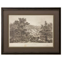
- "Army of the Potomac" by John Bachelder, Civil War Era Lithograph, circa 1863Located in Colorado Springs, COFully-entitled: Army of the Potomac. The Wagon Trains of the Army of the Potomac en Route from Chickahominy to James River VA. During the Seven...Category
Antique 19th Century American Prints
MaterialsPaper
- The Holy Land at the Time of Jesus: A 17th Century Dutch Map by VisscherBy Nicolaes Visscher IILocated in Alamo, CAThis detailed Dutch map entitled "Het Beloofe de Landt Canaan door wandelt van onsen Salichmaecker Iesu Christo, nessens syne Apostelen" by Nicolaes Visscher was published in Amsterd...Category
Antique Mid-17th Century Dutch Maps
MaterialsPaper
- Hampshire County, Britain/England: A Map from Camden's" Britannia" in 1607By John NordenLocated in Alamo, CAAn early hand-colored map of Britain's Hampshire county, published in the 1607 edition of William Camden's great historical description of the British Isles, "Britannia". This map was drawn by cartographer John Norden (c. 1547-1625) and engraved by William Hole (active 1607-1624) and William Kip...Category
Antique Early 17th Century English Maps
MaterialsPaper
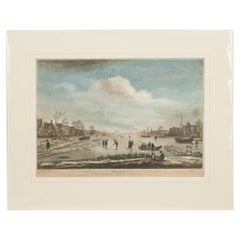
- Dutch Kolf Print, Winter, Golf EngravingLocated in Oxfordshire, GBDutch golf engraving by J. Boydell, Winter. Rare 18th century Dutch golf engraving by J. Boydell depicting Dutchman playing the early form of golf on the ice, titled 'Winter'. The s...Category
Antique 18th Century Dutch Prints
MaterialsPaper
- Large 17th Century Hand Colored Map of England and the British Isles by de WitBy Frederick de WitLocated in Alamo, CAA large hand colored 17th century map of England and the British Isles by Frederick de Wit entitled "Accuratissima Angliæ Regni et Walliæ Principatus", published in Amsterdam in 1680. It is a highly detailed map of England, Scotland, the Scottish Isles...Category
Antique Late 17th Century Dutch Maps
MaterialsPaper


Recently Viewed
View AllMore Ways To Browse
Old Dutch Houses
Vintage British Military
British Army Military
Dutch Navy
Victorian Uniform
Engraving Navy
Dutch Military
Victorian Vintage Illustrations
Victorian Vintage Illustration
Art Lande
Vintage Green Suit
Midcentury Wall Hooks
Antique Garden Decorations
Rustic Diamond
Chinese Chest Antique
Antique Chinese Chests Chests
Antique Chinese Chest
Chinese Antique Chest