Items Similar to The Iron Duke of Alva of Spain Planning the Atrocities Against the Dutch, c.1680
Want more images or videos?
Request additional images or videos from the seller
1 of 6
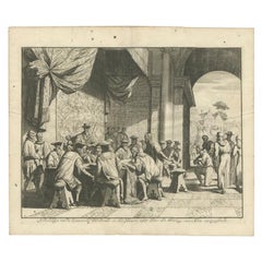
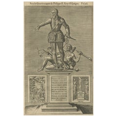
The Iron Duke of Alva of Spain Planning the Atrocities Against the Dutch, c.1680
About the Item
Antique print titled ‘Afbeeldinge van de Spaansche Bloedraad in den Jaare 1567 door den Hartog van Alva aangestelt’.
The Duke of Alva and his entourage seated at a table planning the atrocities against the Dutch in 1567; a bound victim kneels at the right; illustration to Pieter Bor's "Nederlandsche Oorlogen" (Widow of Joannes van Someren, Abraham Wolfgangh & Hendrick en Dirck Boom, Amsterdam: 1679-1684).
Artists and Engravers: Author: Pieter Bor.
- Dimensions:Height: 12.6 in (32 cm)Width: 14.97 in (38 cm)Depth: 0 in (0.02 mm)
- Materials and Techniques:
- Period:1680-1689
- Date of Manufacture:circa 1680
- Condition:Condition: Very good, given age. Minor spots. Please study image carefully.
- Seller Location:Langweer, NL
- Reference Number:
About the Seller
5.0
Platinum Seller
These expertly vetted sellers are 1stDibs' most experienced sellers and are rated highest by our customers.
Established in 2009
1stDibs seller since 2017
1,932 sales on 1stDibs
Typical response time: <1 hour
- ShippingRetrieving quote...Ships From: Langweer, Netherlands
- Return PolicyA return for this item may be initiated within 14 days of delivery.
More From This SellerView All
- Duke of Alva Planning the Atrocities Against the Dutch in 1567, Ca 1680Located in Langweer, NLAntique print titled ‘Afbeeldinge van de Spaansche Bloedraad in den Jaare 1567 door den Hartog van Alva aangestelt’. The Duke of Alva and his entourage seated at a table planning the...Category
Antique 17th Century Prints
MaterialsPaper
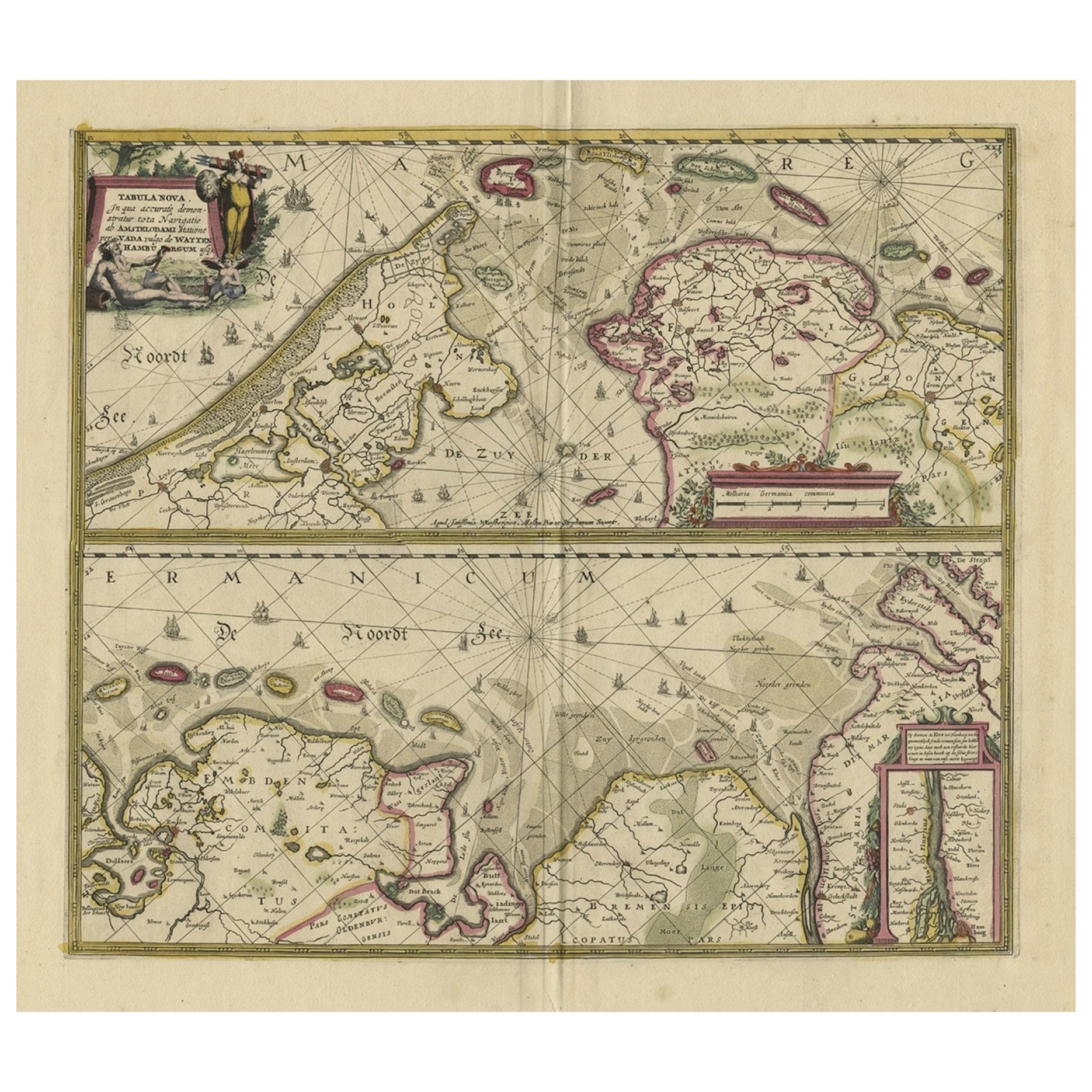
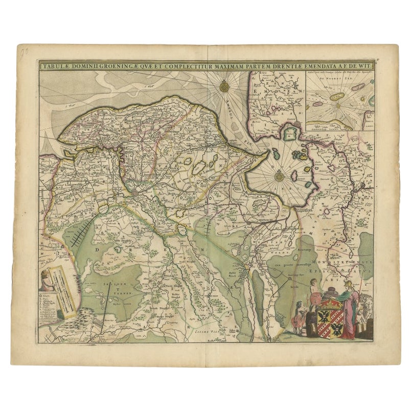
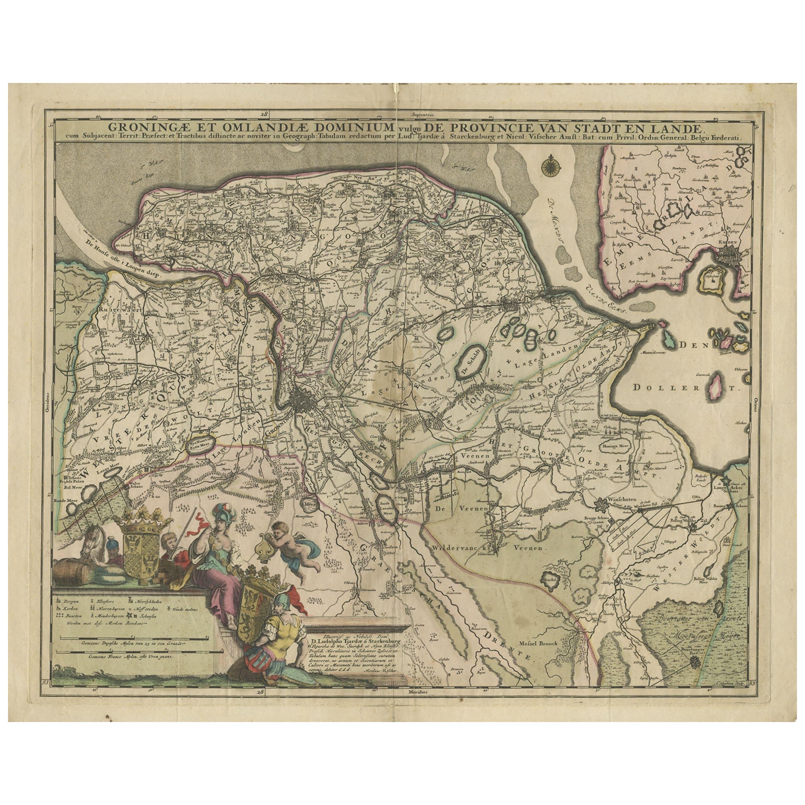
- Antique Map of The Dutch Province of Groningen by De Wit, c.1680Located in Langweer, NLAntique map titled 'Tabulae dominii Groeningae quae et complecitur maximam partem Drentiae Emendata'. Old map of the province of Groningen, the Netherlands. With an inset map of th...Category
Antique 17th Century Maps
MaterialsPaper
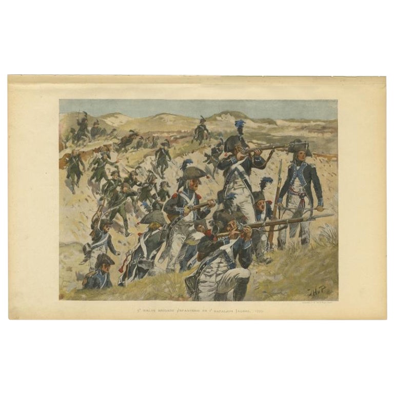
- Dutch Infantry Fighting Against the British Army in the Dunes in 1799Located in Langweer, NLAntique print, titled: '5e Halve Brigade Infanterie en 1e Bataljon Jagers 1799.' - This plate shows the fighting of the Dutch infantry against the British army in the dunes of the pr...Category
20th Century Prints
MaterialsPaper
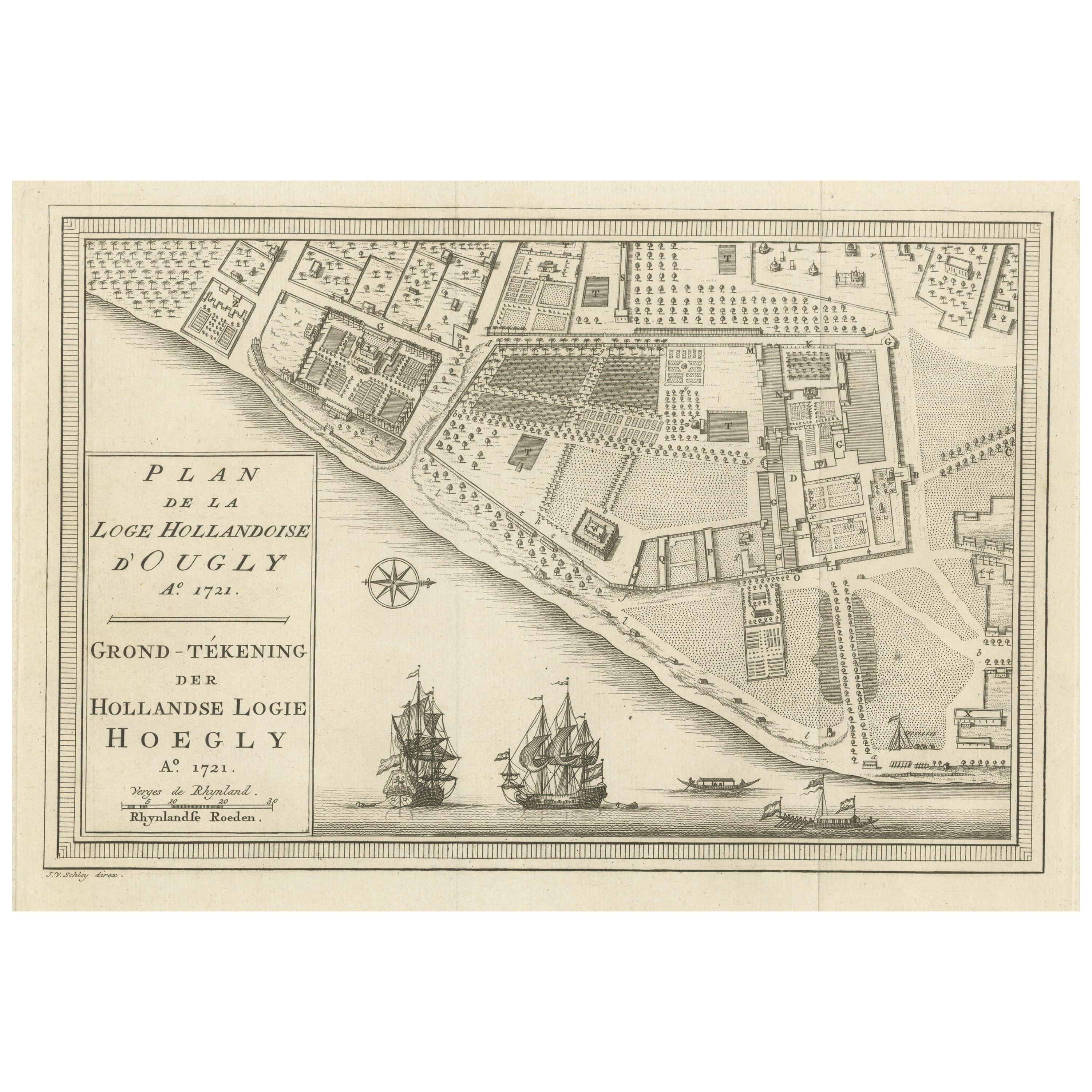
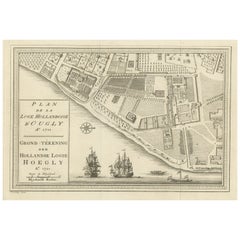
- Original Antique Plan of the Dutch Settlement at Chinsura-Hooghly, India, 1746Located in Langweer, NLAntique print, titled: 'Plan de la Loge Hollandoise d'Ougly'. A plan of the Dutch settlement at Chinsura-Hooghly, India. This print originates from Prevost's 'Histoire Generale d...Category
Antique 1740s Maps
MaterialsPaper
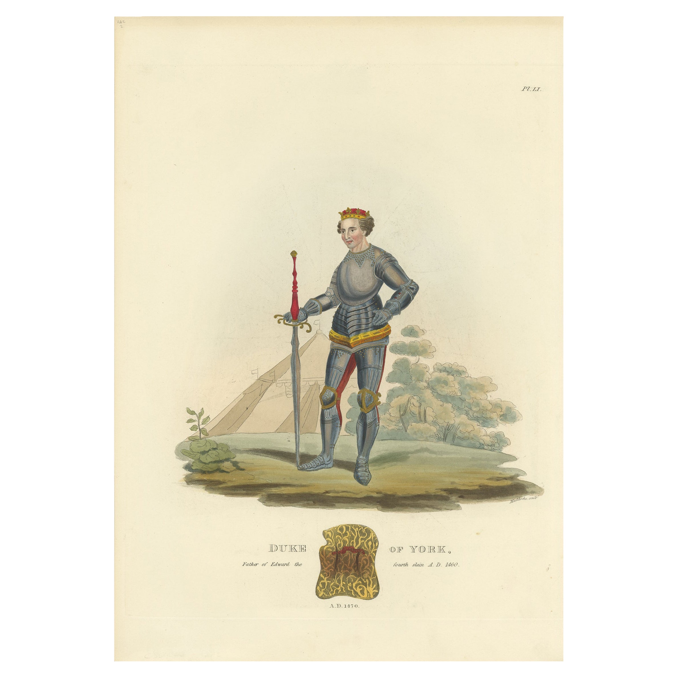
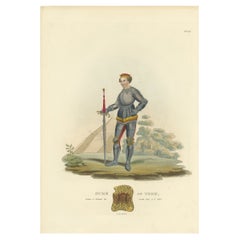
- Antique Print of the Duke of York, 1842Located in Langweer, NLAntique print titled 'Duke of York, father of Edward the fourth slain A.D. 1460'. Old print of the Duke of York. This print originates from 'A critical in...Category
Antique 19th Century Prints
MaterialsPaper
- The Spanish Grand Duke of Alba or Iron Duke in the Netherlands, 1618Located in Langweer, NLAntique portrait titled 'Ferdinando Alvares a Toledo (..)'. Old portrait of Fernando Alvarez de Toledo y Pimentel or Ferdinandus Toletanus Dux Albanus (1507 - 1582), known as the Grand Duke of Alba...Category
Antique 1610s Prints
MaterialsPaper

You May Also Like
- Dutch Map and City Plan of La Roche-sur-Foron, France, 17th Century Hand ColoredBy Coenraet DeckerLocated in Alamo, CA"Rupes Allobrogum vulgo La Roche" by Dutch engraver Coenraet Decker (1650-1685) is from the atlas Theatrum Statuum Regiae Celestudinis Sabaudiae Ducis, published in 1682. This richly...Category
Antique Late 17th Century Dutch Maps
MaterialsPaper
- Set of Twelve Colored Engravings of the Defeat of the Spanish Armada by J. PineLocated in Essex, MABy John Pine considered the foremost heraldic and decorative engraver of his generation. Depicting the defeat of the Spanish by the English Fleet in 1588. These are after a set of tapestries that hung in the House of Commons...Category
Antique 1740s English Prints
MaterialsPaper
- The Holy Land at the Time of Jesus: A 17th Century Dutch Map by VisscherBy Nicolaes Visscher IILocated in Alamo, CAThis detailed Dutch map entitled "Het Beloofe de Landt Canaan door wandelt van onsen Salichmaecker Iesu Christo, nessens syne Apostelen" by Nicolaes Visscher was published in Amsterd...Category
Antique Mid-17th Century Dutch Maps
MaterialsPaper
- Original Antique Map / City Plan of Brussels by Tallis, circa 1850Located in St Annes, LancashireGreat map of Brussels. Steel engraving. Published by London Printing & Publishing Co. (Formerly Tallis), C.1850 Free shipping.Category
Antique 1850s English Maps
MaterialsPaper
- Catalogue of Engraved Views, Plans, Etc., Of New York City, 1st EdLocated in valatie, NYA catalogue of engraved views, plans, etc., Of New York City, (The Collection of Percy R. Pyne II). Privately Printed by The De Vinne Press, New York, 1912. Limited to 100 copies. Gr...Category
Early 20th Century American Books
MaterialsPaper
- Original Antique Map of Spain and Portugal, Engraved By Barlow, 1806Located in St Annes, LancashireGreat map of Spain And Portugal Copper-plate engraving by Barlow Published by Brightly & Kinnersly, Bungay, Suffolk. 1806 Unframed.Category
Antique Early 1800s English Maps
MaterialsPaper


Recently Viewed
View AllMore Ways To Browse
Spanish Wall Table
Iron Bound
Spanish Antique Seat
Antique Table Plans
Antique Booms
Boom Wall
Antique Aubusson Tapestries
Antique Aubusson Tapestry
Designer Wallpaper
Laura Antiques
French Display Shelf
Enamel Glass Box
Swan Cabinet
Aesthetic Vintage Green
Antique Glass Cabinet Cabinets And Cupboards
Midcentury Wool Tapestry
Vintage Black Cabinet Hardware
Antique Commode Chest Marble Top