Items Similar to Old Print of a Boxing Fight Between Two Natives of Hapaee, Tonga Islands, 1803

Want more images or videos?
Request additional images or videos from the seller
1 of 6
Old Print of a Boxing Fight Between Two Natives of Hapaee, Tonga Islands, 1803
About the Item
Antique print titled 'Vuist-Gevegt van de Inboorlingen van Hapaee'.
Antique print depicting a fight between two natives of Hapaee. Originates from 'Reizen Rondom de Waereld door James Cook (..)'.
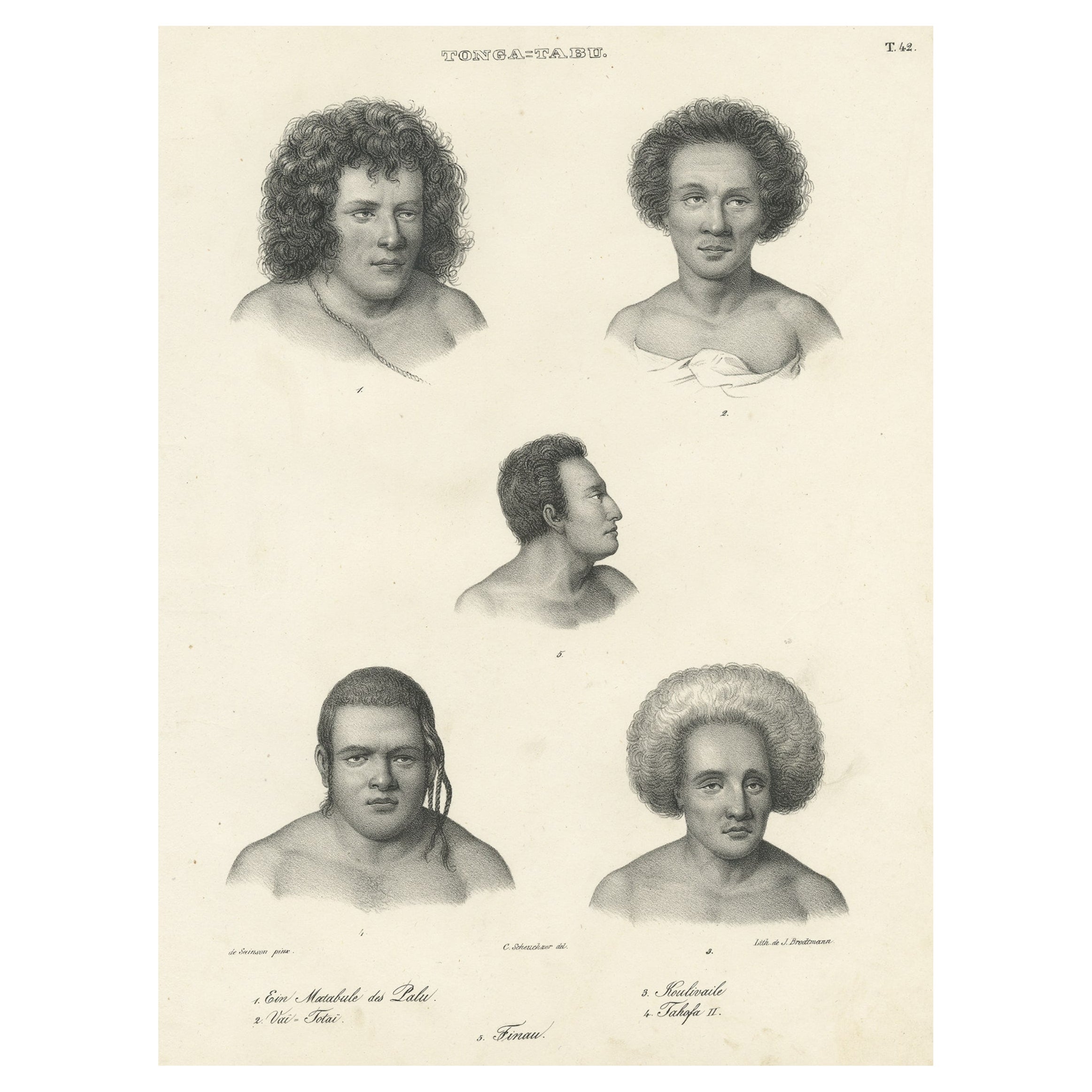
Ha'apai is one of the islands of Tonga, where Webber sketched the locals and their customs. The entertainment was provided for Cook and his crew on the beach upon his arrival on the Island. Cook remarked in his account that the boxing closely resembled that of England and the wrestling matches that also occurred were of the "same manner" as seen in Tahiti.
Artists and Engravers: Translated by J.D. Pasteur. Published by Honkoop, Allart en Van Cleef.
- Dimensions:Height: 9.06 in (23 cm)Width: 5.91 in (15 cm)Depth: 0 in (0.02 mm)
- Materials and Techniques:
- Period:1800-1809
- Date of Manufacture:1803
- Condition:Wear consistent with age and use. Condition: Very good, please study image carefully.
- Seller Location:Langweer, NL
- Reference Number:
About the Seller
5.0
Platinum Seller
These expertly vetted sellers are 1stDibs' most experienced sellers and are rated highest by our customers.
Established in 2009
1stDibs seller since 2017
1,922 sales on 1stDibs
Typical response time: <1 hour
- ShippingRetrieving quote...Ships From: Langweer, Netherlands
- Return PolicyA return for this item may be initiated within 14 days of delivery.
More From This SellerView All
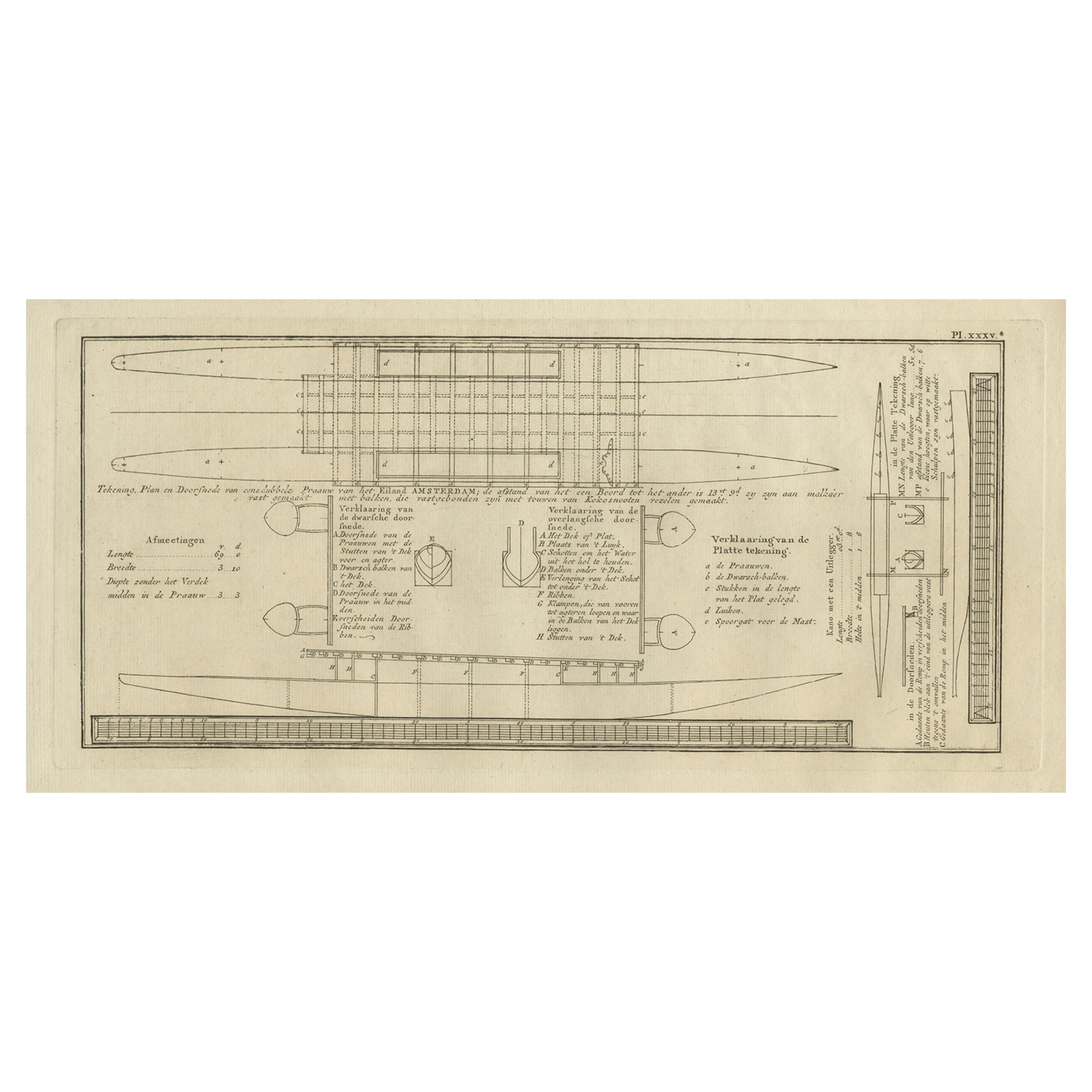
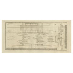
- Old Drawing or Plan of a Proa of Amsterdam Island, Now Tongatapu, Tonga, 1803Located in Langweer, NLAntique print titled 'Tekening, Plan en Doorsnede van eene dubbele Praauw (..)'. Antique print depicting a drawing, plan and cross-section of a proa of Amsterdam Island. Amsterda...Category
Antique Early 1800s Prints
MaterialsPaper
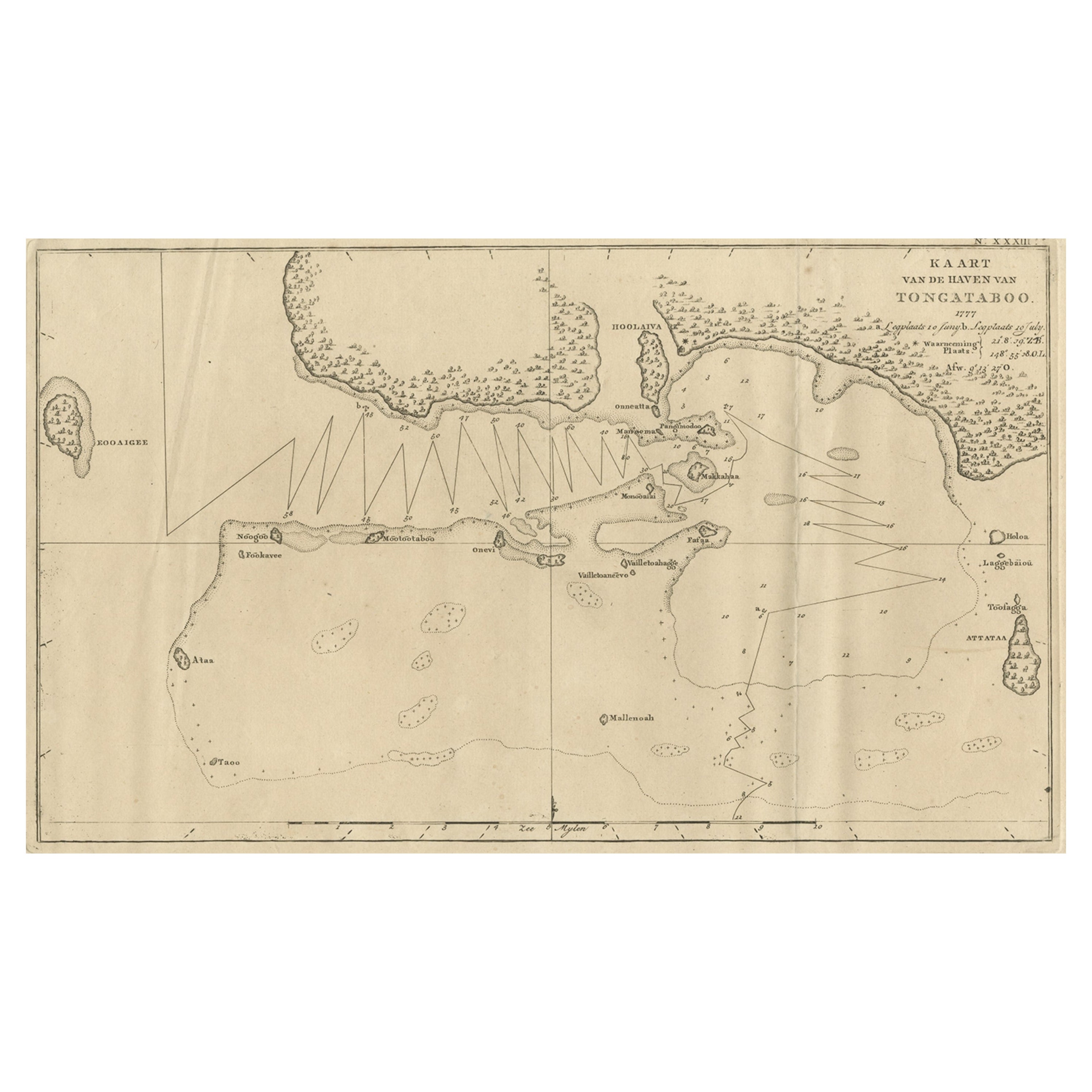
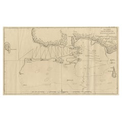
- Antique Map of the Harbour of Tongatabu, One of the Tonga Islands, 1803Located in Langweer, NLAntique map Tonga titled 'Kaart van de Haven van Tongataboo'. Antique map of the harbour of Tongatabu, one of the Tonga Islands. Originates from 'Reizen Rondom de Waereld door Ja...Category
Antique Early 1800s Maps
MaterialsPaper
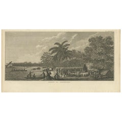
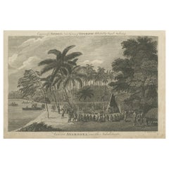
- Antique Print of Annamooka, Tonga Islands, by Cook '1803'Located in Langweer, NLAntique print titled 'Gezigt op Annamooka'. This print depicts the Harbour of Annamooka, now Nomuka, part of the Ha’apai group of Tonga. Originates from 'Reizen rondom de Waereld' by...Category
Antique Early 19th Century Dutch Prints
MaterialsPaper
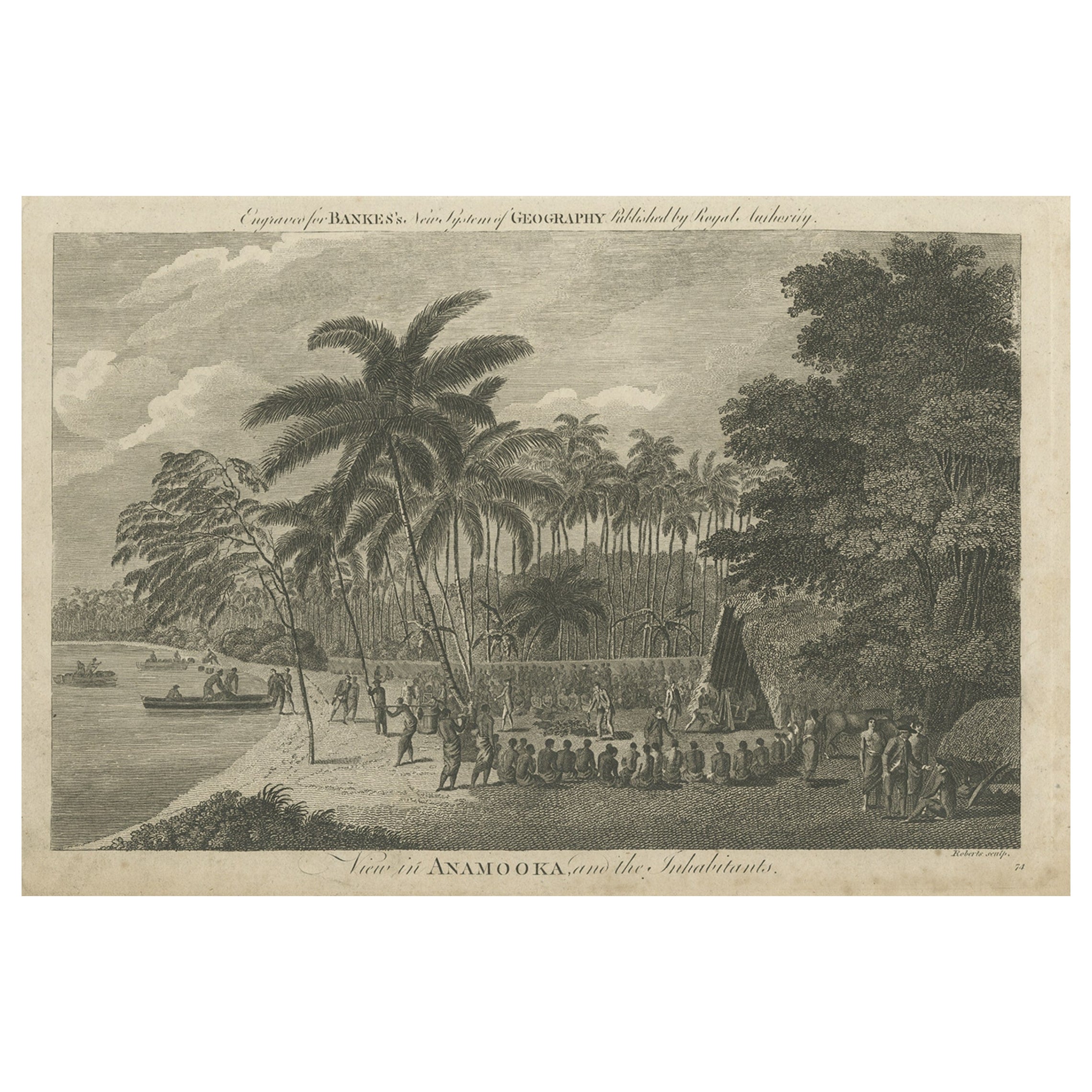
- Antique Print of the Marketplace in Anamooka, Tonga Islands, c.1790Located in Langweer, NLAntique print titled 'View in Anamooka and the Inhabitants'. Depicts the marketplace that was established in a ring in front of the main house in Anamooka, Tonga - named the Friendly Islands because of his reception when James Cook's third Pacific voyage arrived there in May 1777. Artists and Engravers: Engraved for Bankes's 'New System of Geography'. Published by Royal Authority. Condition: Good, age-related toning. Please study image carefully. Date: c.1790 Overall size: 38.6 x 23.2 cm. Image size: 30.6 x 21.5 cm. A View at Anamooka This engraving after a drawing comes from the official account of Cook's third voyage, 'A voyage to the Pacific Ocean'. Captain James Cook (1728-1779) made three separate voyages to the Pacific (with the ships Endeavour, Resolution, Adventure, and Discovery) and did more than any other voyager to explore the Pacific and Southern Ocean. Cook not only encountered Pacific cultures for the first time, but also assembled the first large-scale collections of Pacific objects to be brought back to Europe. He was killed in Hawaii in 1779. Cook was in Nomuka (Annamooka), Tonga or Friendly Isles from May 1-14, 1777. "On May 2 1777 the expedition reached Nomuka and anchored in the harbour on the north side of the island, which Cook had already used in June 1774. Both ships were in want of refreshments. A camp was erected on shore both as a trading post and a workshop for repairs. Watering, cutting wood...Category
Antique 18th Century Prints
MaterialsPaper
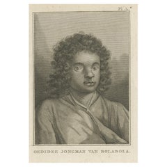
- Antique Print of Oedidee, a Native from Bora Bora, 1803Located in Langweer, NLAntique print titled 'Oedidee Jongman van Bolabola'. Antique print of Oedidee, a native from Bora Bora. Originates from 'Reizen Rondom de Waereld door James Cook (..)'. Artis...Category
Antique Early 1800s Maps
MaterialsPaper
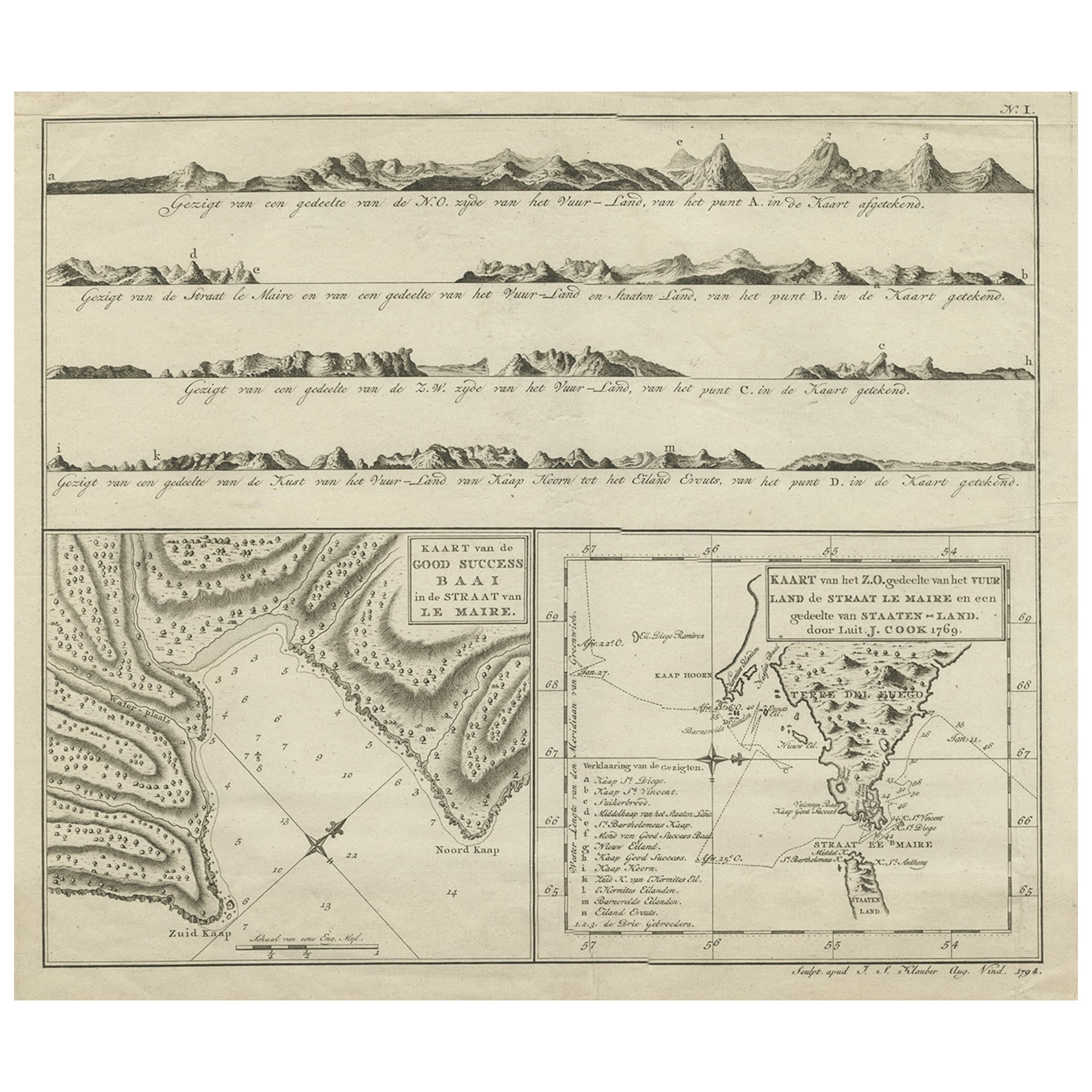
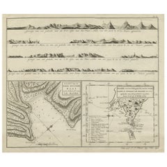
- Antique Map of the Strait of Le Maire Between Terra Fuego & Staten Island, 1803Located in Langweer, NLAntique map titled 'Kaart van de Good Success Baai in de Straat van Le Maire (..)'. Antique map of the Strait of Le Maire between Terra Fuego and Staten Island. On top, various c...Category
Antique Early 1800s Maps
MaterialsPaper
You May Also Like
- Old Nautical Print Depicting the Bombardment of Cadiz by the French Navy 1823Located in Milan, ITPrint by engraving on copper plate of the first half of the 19th century, depicting the bombardment of Cadiz by the French Navy, 23 September 1823. The print is signed peint par Crep...Category
Antique 1830s French Nautical Objects
MaterialsPaper
- Old Nautical Map of CorsicaLocated in Alessandria, PiemonteST/556/1 - Old map of Corsica isle, surveyed by Captain Hell, of the French Royal Navy in 1824, engraved and published on 1874, with additions and corre...Category
Antique Early 19th Century English Other Prints
MaterialsPaper
- Old Horizontal Map of EnglandBy TassoLocated in Alessandria, PiemonteST/520 - Old rare Italian map of England, dated 1826-1827 - by Girolamo Tasso, editor in Venise, for the atlas of M.r Le-Sage.Category
Antique Early 19th Century Italian Other Prints
MaterialsPaper
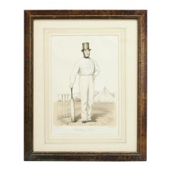
- Antique Cricket Print of Joseph Guy of NottinghamLocated in Oxfordshire, GBCricket print of Joseph Guy of Nottingham. A framed, tinted and hand colored lithographic portrait of the All- England cricketer Joseph Guy (1813 - 187...Category
Antique 1850s British Sporting Art Sports Equipment and Memorabilia
MaterialsPaper
- Oleo-print "Mary Mother of God"Located in Chorzów, PLDimensions: Frame: height 71.5 cm / width 55 cm Oleo printing: 63 cm high.Category
Vintage 1960s Polish Other Religious Items
MaterialsCanvas, Beech
- Hand-Colored 18th Century Homann Map of Denmark and Islands in the Baltic SeaBy Johann Baptist HomannLocated in Alamo, CAAn 18th century copper plate hand-colored map entitled "Insulae Danicae in Mari Balthico Sitae utpote Zeelandia, Fionia, Langelandia, Lalandia, Falstria, Fembria Mona" created by Joh...Category
Antique Early 18th Century German Maps
MaterialsPaper


Recently Viewed
View AllMore Ways To Browse
Antique Entertainment
Van Cleef Between
Antique Wrestling
Gray Cleef
Van Cleef Gray
Antique Print Beach
Antique Ha
Boxing Match
The Two Wrestlers
Antique Boxing Prints
Antique Tapestry Framed
Framed Antique Tapestry
Pair Of Chest Nightstand
Wall Hook Hand
Tapestry Border
Vintage Suit Pink
Black Silk Rug
Large Antique Wood Doors