Items Similar to Old Drawing or Plan of a Proa of Amsterdam Island, Now Tongatapu, Tonga, 1803

Want more images or videos?
Request additional images or videos from the seller
1 of 5
Old Drawing or Plan of a Proa of Amsterdam Island, Now Tongatapu, Tonga, 1803
About the Item
Antique print titled 'Tekening, Plan en Doorsnede van eene dubbele Praauw (..)'.
Antique print depicting a drawing, plan and cross-section of a proa of Amsterdam Island. Amsterdam Island was discovered by Abel Tasman in 1643 and named as such because of it's abundance of supplies. It is now named Tongatapu, the main island of the Kingdom of Tonga. Originates from 'Reizen Rondom de Waereld door James Cook (..)'.
Artists and engravers: Translated by J.D. Pasteur. Published by Honkoop, Allart en Van Cleef.
- Dimensions:Height: 10.24 in (26 cm)Width: 16.54 in (42 cm)Depth: 0 in (0.02 mm)
- Materials and Techniques:
- Period:
- Date of Manufacture:1803
- Condition:Condition: Very good, general age-related toning. Please study image carefully.
- Seller Location:Langweer, NL
- Reference Number:
About the Seller
5.0
Platinum Seller
These expertly vetted sellers are 1stDibs' most experienced sellers and are rated highest by our customers.
Established in 2009
1stDibs seller since 2017
1,929 sales on 1stDibs
Typical response time: <1 hour
- ShippingRetrieving quote...Ships From: Langweer, Netherlands
- Return PolicyA return for this item may be initiated within 14 days of delivery.
More From This SellerView All
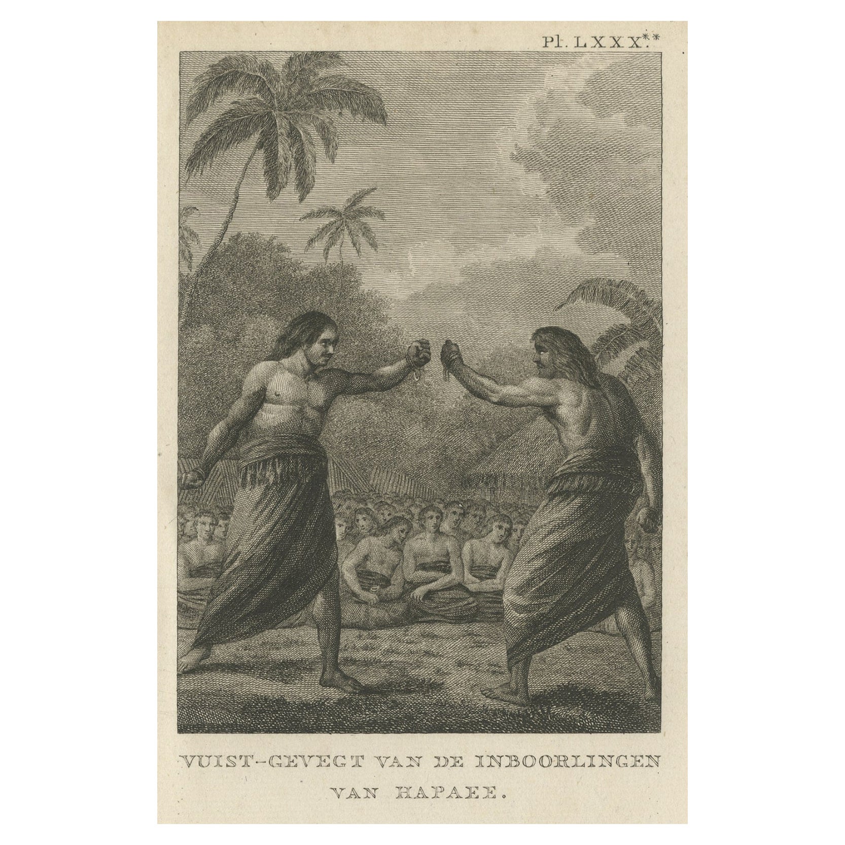
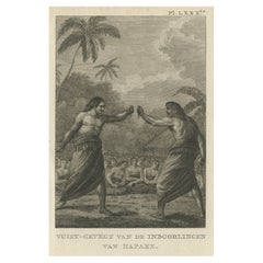
- Old Print of a Boxing Fight Between Two Natives of Hapaee, Tonga Islands, 1803Located in Langweer, NLAntique print titled 'Vuist-Gevegt van de Inboorlingen van Hapaee'. Antique print depicting a fight between two natives of Hapaee. Originates from 'Reizen Rondom de Waereld door ...Category
Antique Early 1800s Prints
MaterialsPaper
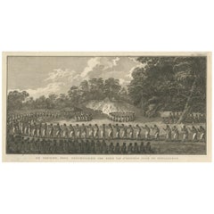
- Ceremony for the Son of the King in the Village of Mua on Tongatapu, Tonga, 1803Located in Langweer, NLAntique print titled 'De Natsche, eene plechtigheid ter eere van 's Konings Zoon op Tongataboo'. Antique print depiciting a ceremony for the son of the King of Tonga in the villa...Category
Antique Early 1800s Prints
MaterialsPaper
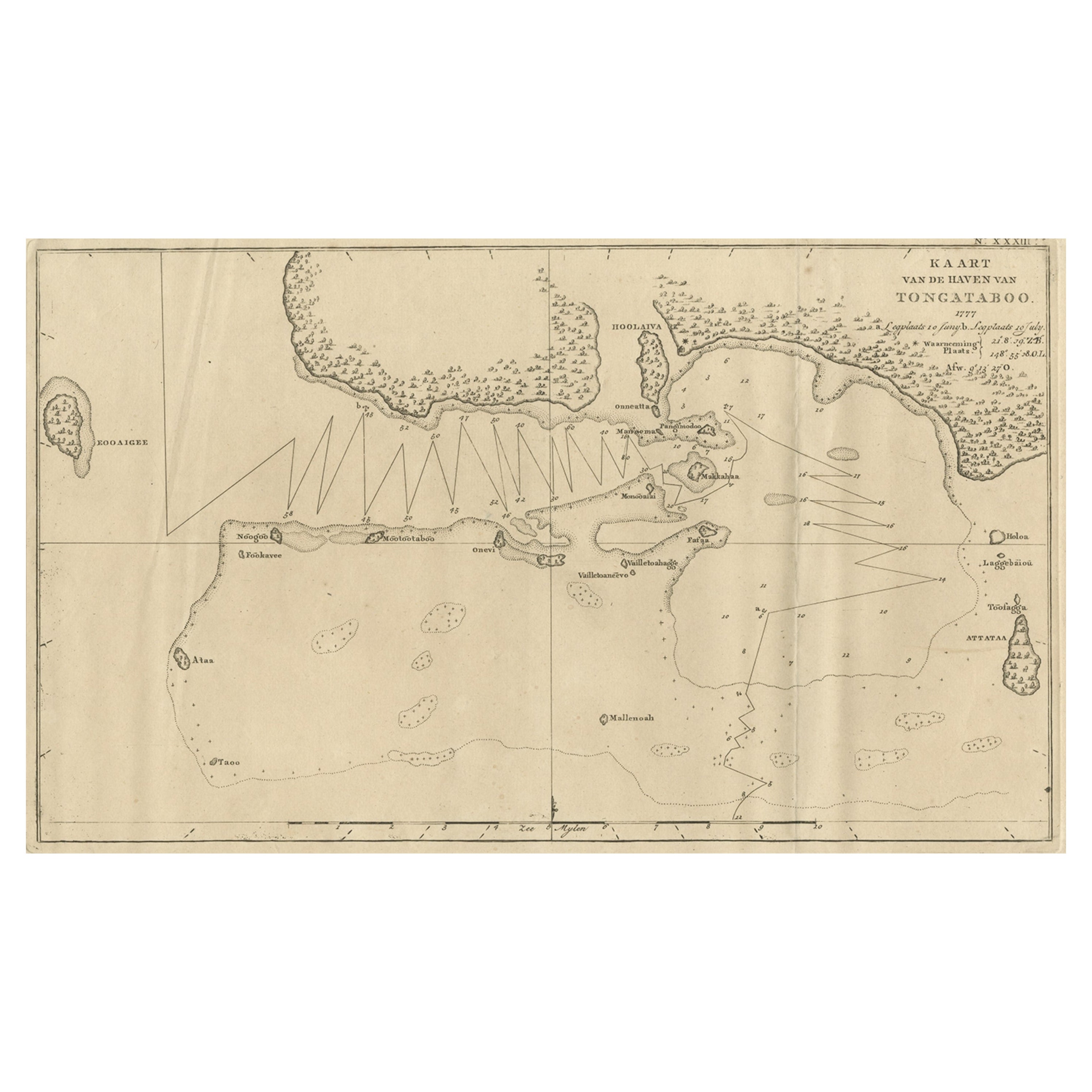
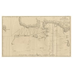
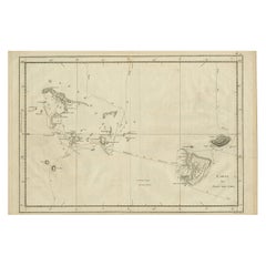
- Antique Map of the Harbour of Tongatabu, One of the Tonga Islands, 1803Located in Langweer, NLAntique map Tonga titled 'Kaart van de Haven van Tongataboo'. Antique map of the harbour of Tongatabu, one of the Tonga Islands. Originates from 'Reizen Rondom de Waereld door Ja...Category
Antique Early 1800s Maps
MaterialsPaper
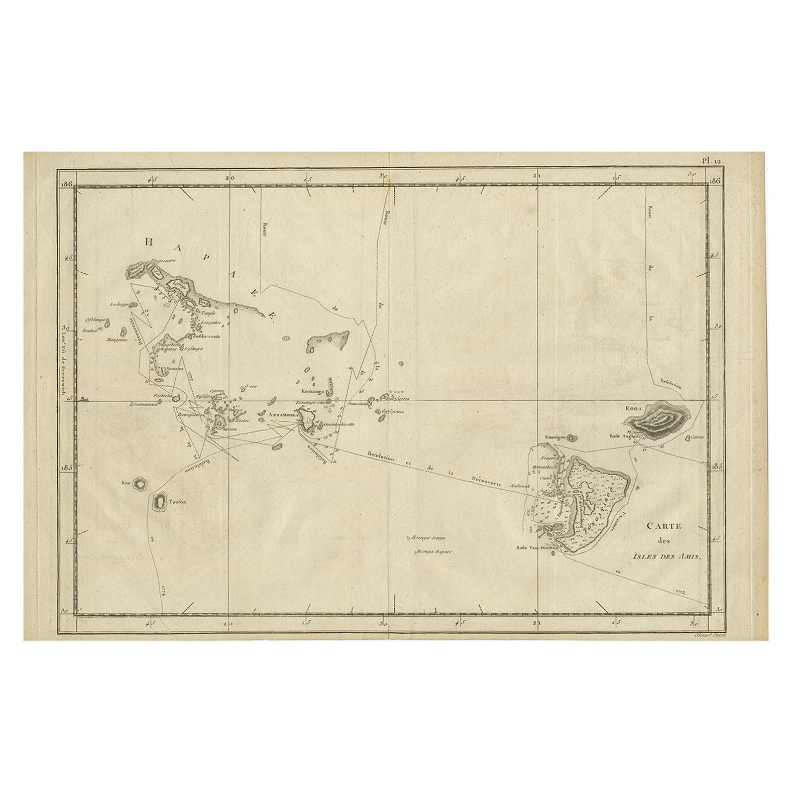
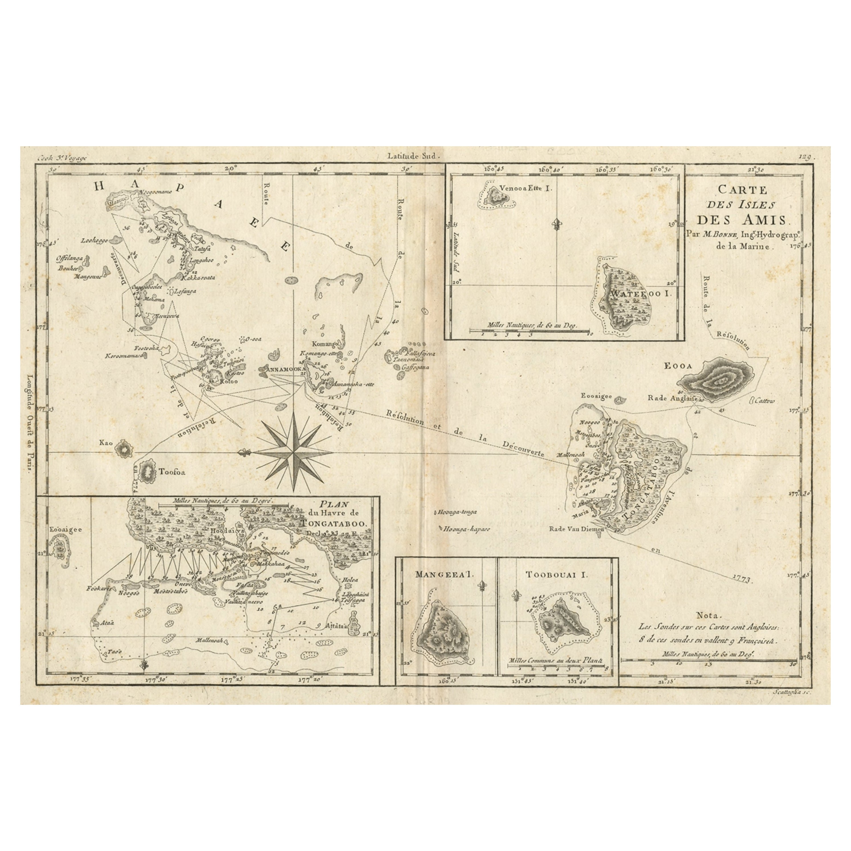
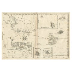
- Antique Engraved Map of the Friendly Islands or Tonga, ca.1785Located in Langweer, NLAntique map titled 'Carte des Isles des Amis'. Map of the Friendly Islands / Tonga. The Tongan people first encountered Europeans in 1616 when the Dutch vessel Eendracht, captain...Category
Antique 1780s Maps
MaterialsPaper
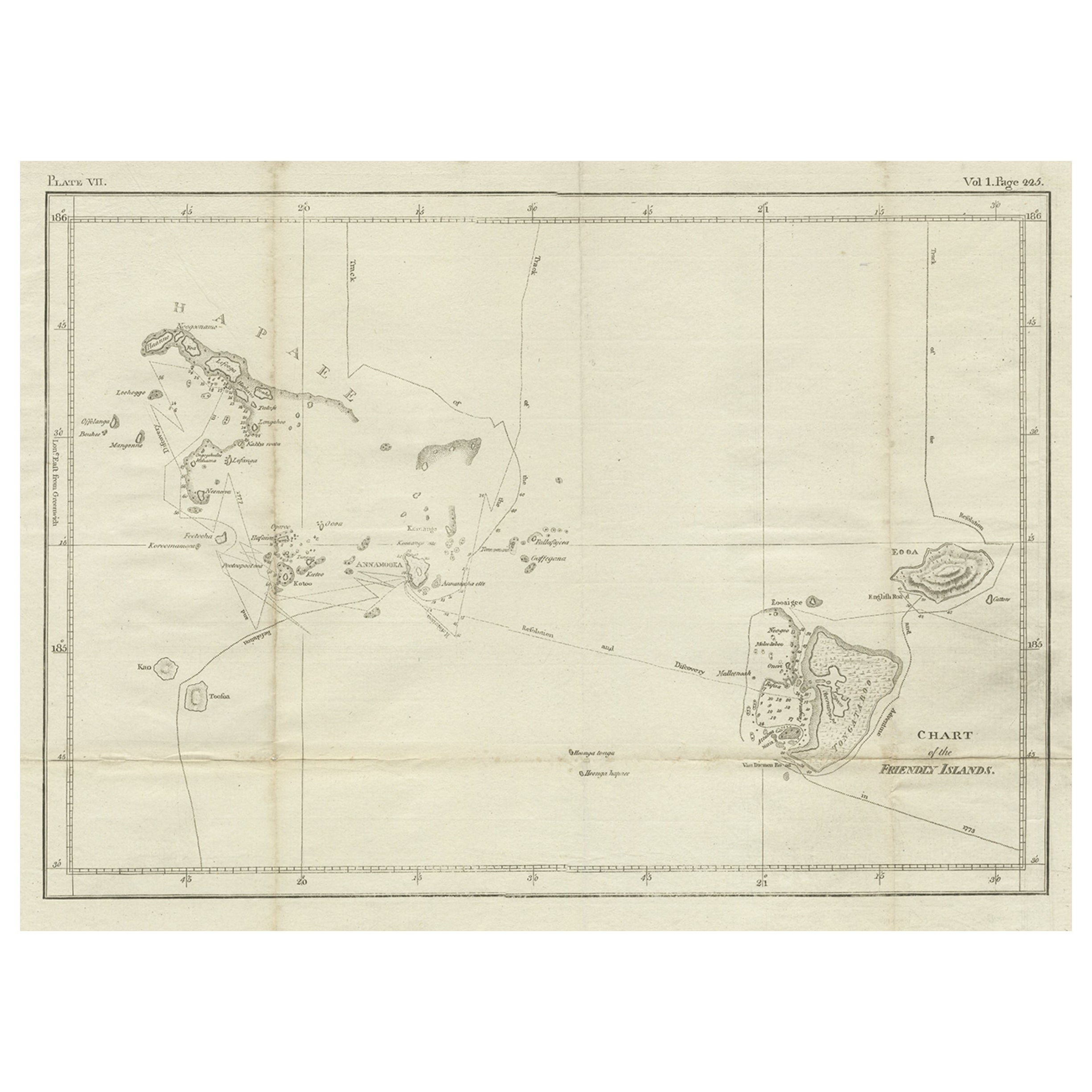
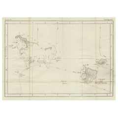
- Antique Chart of the Friendly Islands or Nowadays Tonga, by Cook, 1784By James CookLocated in Langweer, NLAntique print titled 'Chart of the Friendly Islands'. Antique map of the Friendly Islands depicting Rotterdam or Anamocka, Middelburg or Eaoowe and Amsterdam or Tongatabu. Originates...Category
Antique 18th Century Prints
MaterialsPaper
- Old Map of the Kingdom of Tonga, Also Known as the Friendly Islands, ca.1780Located in Langweer, NLAntique print, titled: 'Carte des Isles des Amis.' Map of the Kingdom of Tonga, also known as the Friendly Islands, and one of the last hereditary monarchies. Cook named this gro...Category
Antique 1780s Maps
MaterialsPaper
You May Also Like
- Old Nautical Map of CorsicaLocated in Alessandria, PiemonteST/556/1 - Old map of Corsica isle, surveyed by Captain Hell, of the French Royal Navy in 1824, engraved and published on 1874, with additions and corre...Category
Antique Early 19th Century English Other Prints
MaterialsPaper
- Old Horizontal Map of EnglandBy TassoLocated in Alessandria, PiemonteST/520 - Old rare Italian map of England, dated 1826-1827 - by Girolamo Tasso, editor in Venise, for the atlas of M.r Le-Sage.Category
Antique Early 19th Century Italian Other Prints
MaterialsPaper
- Catalogue of Engraved Views, Plans, Etc., Of New York City, 1st EdLocated in valatie, NYA catalogue of engraved views, plans, etc., Of New York City, (The Collection of Percy R. Pyne II). Privately Printed by The De Vinne Press, New York, 1912. Limited to 100 copies. Gr...Category
Early 20th Century American Books
MaterialsPaper
- Original Antique Map / City Plan of Brussels by Tallis, circa 1850Located in St Annes, LancashireGreat map of Brussels. Steel engraving. Published by London Printing & Publishing Co. (Formerly Tallis), C.1850 Free shipping.Category
Antique 1850s English Maps
MaterialsPaper
- Dutch Map and City Plan of La Roche-sur-Foron, France, 17th Century Hand ColoredBy Coenraet DeckerLocated in Alamo, CA"Rupes Allobrogum vulgo La Roche" by Dutch engraver Coenraet Decker (1650-1685) is from the atlas Theatrum Statuum Regiae Celestudinis Sabaudiae Ducis, published in 1682. This richly...Category
Antique Late 17th Century Dutch Maps
MaterialsPaper
- Hand-Colored 18th Century Homann Map of Denmark and Islands in the Baltic SeaBy Johann Baptist HomannLocated in Alamo, CAAn 18th century copper plate hand-colored map entitled "Insulae Danicae in Mari Balthico Sitae utpote Zeelandia, Fionia, Langelandia, Lalandia, Falstria, Fembria Mona" created by Joh...Category
Antique Early 18th Century German Maps
MaterialsPaper


Recently Viewed
View AllMore Ways To Browse
Antique Supplies
D Abel
Silk Antique Tapestries Silk Tapestries
Antique Silk Tapestry
20th Century French Tapestry
Antique Wall Shelf
Single Glass Door Cabinet
Wall Shelf Antique
Vintage Wood Corner Cabinet
Antique Ladies Sign
Leaves Dress
Hand Slicer
Oak Tall Cabinet
Retro Country Kitchen
Sculptural Fashion Design
Round Deco Bar
Unique Front Door
Antique French Wall Tapestry