Want more images or videos?
Request additional images or videos from the seller
1 of 11
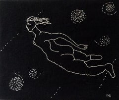
Unknown"The Bermudas Hand-Stitched c1938 Island Map"1938
1938
$1,200List Price
About the Seller
4.8
Vetted Professional Seller
Every seller passes strict standards for authenticity and reliability
Established in 2000
1stDibs seller since 2019
135 sales on 1stDibs
Typical response time: 1 hour
Authenticity Guarantee
In the unlikely event there’s an issue with an item’s authenticity, contact us within 1 year for a full refund. DetailsMoney-Back Guarantee
If your item is not as described, is damaged in transit, or does not arrive, contact us within 7 days for a full refund. Details24-Hour Cancellation
You have a 24-hour grace period in which to reconsider your purchase, with no questions asked.Vetted Professional Sellers
Our world-class sellers must adhere to strict standards for service and quality, maintaining the integrity of our listings.Price-Match Guarantee
If you find that a seller listed the same item for a lower price elsewhere, we’ll match it.Trusted Global Delivery
Our best-in-class carrier network provides specialized shipping options worldwide, including custom delivery.You May Also Like
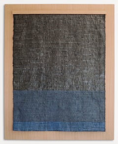
Leather woven artwork with sunset color gradient
Located in San Francisco, CA
"Sunset" by Cécilia Lusven is handwoven from linen and off-cut leathers. Lusven's signature style involves hand-cutting the leather scraps into same size fringe pieces that are then ...
Category
2010s Abstract More Art
Materials
Leather, Linen, Textile, Wood
$9,500
H 48.5 in W 35.5 in D 2.75 in
Leather woven artwork with grey fringes on wood
Located in San Francisco, CA
"Horizon" by Cécilia Lusven is handwoven from linen and off-cut leathers. Lusven's signature style involves hand-cutting the leather scraps into same size fringe pieces that are then...
Category
2010s Abstract More Art
Materials
Leather, Textile, Linen, Wood
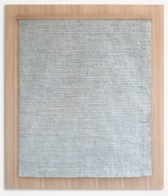
$9,500
H 46.5 in W 40 in D 2.75 in
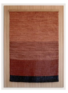
Leather woven artwork with blue and black color gradient on wood
Located in San Francisco, CA
"Abyss" by Cécilia Lusven is handwoven from linen and off-cut leathers and discarded bicycle inner tubes, Lusven's signature style involves hand-cutting the leather scraps into same ...
Category
2010s Abstract More Art
Materials
Leather, Textile, Linen, Wood
$11,000
H 49.5 in W 40 in D 2.75 in
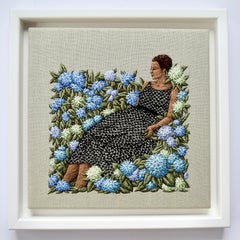
The Earth Will Open Up for Us
By Michelle Kingdom
Located in Santa Monica, CA
45.72 x 58.42 cm
Category
21st Century and Contemporary More Art
Materials
Linen
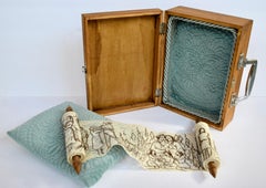
We tell each other stories
By Michelle Kingdom
Located in Santa Monica, CA
rolled scroll, hand embroidered on vintage lace Placed in a lined wood box with pillow
Category
21st Century and Contemporary More Art
Materials
Linen
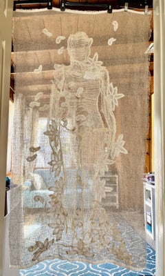
Full of Sleep
By Michelle Kingdom
Located in Santa Monica, CA
Hand embroidery and applique using cheesecloth and vintage lace on linen
Category
21st Century and Contemporary More Art
Materials
Linen

Full of Sleep
By Michelle Kingdom
Located in Santa Monica, CA
Hand embroidery and applique using cheesecloth and vintage lace on linen
Category
21st Century and Contemporary Art Nouveau More Art
Materials
Linen
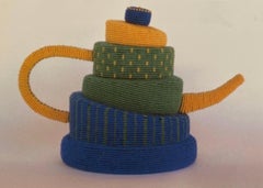
Topsy Turvy II
Located in Santa Monica, CA
C-lon thread, waxed linen, styrofoam.
Category
2010s More Art
Materials
Linen, Thread
Shelter In Space
By Peg Grady
Located in Santa Monica, CA
Thread on linen
Category
2010s Contemporary More Art
Materials
Linen, Thread
3rd to 5th Century Coptic Egyptian Textile fragment beige dark blue Brocade
Located in Austin, TX
Textile size 8.5 x 10 in.
Frame size 13.5 x 15 in.
This piece is an ancient Coptic Egyptian textile fragment, dating from the 3rd to 5th century CE. It is composed of a coarse, plai...
Category
15th Century and Earlier More Art
Materials
Textile, Linen, Dye
More From This Seller
View All"Golden Eye Decoy" Oil on Linen by Albert Edward Sandecki (American, b.1935-)
Located in Bristol, CT
Art Sz: 15 1/2"H x 19 1/2"W
Frame Sz: 19 3/8"H x 23"W
"Golden Eye Decoy", oil on linen, signed lower left, titled verso,
with his Haddonfield, NJ address
and label from James Graham...
Category
20th Century Paintings
Materials
Linen, Oil

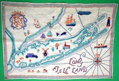
"Long Isle Land c1930s Crewelwork Linen Embroidered Map"
Located in Bristol, CT
Sz: 18"H x 26"W
Category
1930s Mixed Media
Materials
Linen
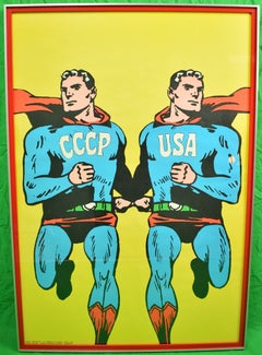
Superpowers
By Roman Cieslewicz
Located in Bristol, CT
Iconic original parchment linen poster 'Superpowers' c1968 by noted Polish graphic artist Roman Cieslewicz (1930-1996)
Poster Sz: 31 1/4"H x 21"W
Frame Sz: 32 1/2"H x 22 1/2"W
w/ ...
Category
1960s Other Art Style Portrait Prints
Materials
Linen, Parchment Paper
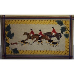
Hand-Needlepoint Fox-Hunt Bench/ Table Signed: MT 98
Located in Bristol, CT
Sz: 45 1/2"W x 28"L x 20"H
Category
20th Century More Art
Materials
Wool, Wood
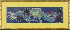
Chinese Needlepoint Dragon
Located in Bristol, CT
c1960s needlepoint depicting a Chinese dragon
Panel Sz: 6"H x 21"W
Frame Sz: 10 7/8"H x 25 7/8"W
w/ yellow matte & gilt bamboo frame
Category
1960s More Art
Materials
Wool
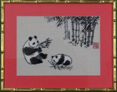
Needlepoint Pandas
Located in Bristol, CT
c1960s mum & cub pandas
Art Sz: 9 1/2"H x 13 1/2"W
Frame Sz: 14 7/8"H x 18 3/4"W
w/ coral mat & gilt bamboo frame
Category
1960s More Art
Materials
Wool