Items Similar to 1864 Original illustrated planisphere - World Map - Geography


Want more images or videos?
Request additional images or videos from the seller
1 of 7
Charpentier1864 Original illustrated planisphere - World Map - Geography1864
1864
$4,112.46
£3,139.05
€3,500
CA$5,800.83
A$6,371.96
CHF 3,330.03
MX$75,990.91
NOK 42,167.14
SEK 39,282.24
DKK 26,676.72
About the Item
Immerse yourself in the epic journey of the past with the Illustrated Historical Planisphere of 1864 by Charpentier! 🗺️ This cartographic treasure transports you through the intricacies of history, with meticulous details and captivating illustrations. Explore ancient empires, trace trade routes, and relive the great discoveries that shaped our world. A true collector's item, this cartographic masterpiece will delight history enthusiasts and lovers of beautiful objects alike. Add a touch of elegance and wonder to your interior with this unique Historical Planisphere. 📜✨
Map - Geography
Edit : Danlos
Print : Goyer Paris
- Creator:Charpentier
- Creation Year:1864
- Dimensions:Height: 32.29 in (82 cm)Width: 44.49 in (113 cm)
- Medium:
- Period:
- Condition:Good condition, slight soiling, on linen.
- Gallery Location:PARIS, FR
- Reference Number:1stDibs: LU1792212680932
About the Seller
5.0
Gold Seller
Premium sellers maintaining a 4.3+ rating and 24-hour response times
Established in 2021
1stDibs seller since 2022
192 sales on 1stDibs
Typical response time: 3 hours
- ShippingRetrieving quote...Shipping from: PARIS, France
- Return Policy
More From This Seller
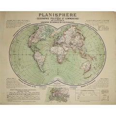
View AllCirca 1900 original poster Planisphère de géographie politique et commercial
Located in PARIS, FR
This circa 1900 original poster, "Planisphère de Géographie Politique et Commerciale," is a fascinating artifact of early 20th-century cartography, created by H. Bouthillier de Beaum...
Category
Early 1900s Prints and Multiples
Materials
Lithograph, Paper
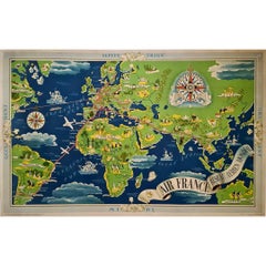
1937 Original planisphere by Lucien boucher - World map
By Lucien Boucher
Located in PARIS, FR
Original poster
Airline Company - Map - Tourism
West - Northern - Orient - Midi
In 1937, Lucien Boucher, a renowned French illustrator, unveiled his masterpiece, the "Planisphère ...
Category
1930s Prints and Multiples
Materials
Linen, Lithograph, Paper
1935 original map French exploration in North America
Located in PARIS, FR
In 1935, a remarkable map titled "Les Français au Cœur de l'Amérique" was produced, highlighting the rich history of French exploration and influence in North America. This map is a ...
Category
1930s Prints and Multiples
Materials
Lithograph, Paper
1851 Original map by Maillard - Plan de Paris et ses Fortifications
Located in PARIS, FR
In the world of cartography, maps transcend mere geography; they are historical records and works of art, encapsulating the essence of a place at a specific moment in time. The 1851 ...
Category
1850s Prints and Multiples
Materials
Paper, Lithograph, Linen

Jacques Liozu's 1951 illustrated map of South America
By Jacques Liozu
Located in PARIS, FR
Jacques Liozu's 1951 illustrated map of South America is an exceptional work of cartography that skilfully blends art and geography. French artist and cartographer Jacques Liozu crea...
Category
1950s Prints and Multiples
Materials
Lithograph, Paper

Circa 1825 original engraving of the map of Syria by Giraldon Bovinet
Located in PARIS, FR
The circa 1825 original engraving of "Syrie" by Giraldon Bovinet, based on the work of L. Vivien, is a historically significant map that reflects early 19th-century cartographic tech...
Category
1820s Prints and Multiples
Materials
Engraving, Paper

You May Also Like
Antique Map of the World in Hemispheres by Johnson, '1872'
Located in Langweer, NL
Antique map titled 'Johnson's Globular World. Original world map depicting the Eastern Hemisphere and the Western Hemisphere. This map originates fr...
Category
Antique Late 19th Century Maps
Materials
Paper

Antique Map of The World in Hemispheres by W. G. Blackie, 1859
Located in Langweer, NL
Antique map titled 'The World in Hemispheres with other projections'. Original antique map of The World. This map originates from ‘The Imperial Atlas of Modern Geography’. Published ...
Category
Antique Mid-19th Century Maps
Materials
Paper

$287 Sale Price
30% Off
Antique Map of the World by D'Urville '1853'
Located in Langweer, NL
Antique map titled 'Voyage Autour du Monde'. Original map of the world. This map originates from volume 1 of 'Voyage Autour du Monde' by Comte-Amiral Dumont D'Urville.
Category
Antique Mid-19th Century Maps
Materials
Paper

$282 Sale Price
20% Off
Antique Map of the World by A. Vuillemin, 1854
By Victor Levasseur
Located in Langweer, NL
This map originates from ‘Atlas National de la France Illustré’. Published by A. Combette, Paris, 1854.
Category
Antique Mid-19th Century Maps
Materials
Paper

$330 Sale Price
25% Off
Antique Map of The World in Hemispheres on Various Projections, 1882
Located in Langweer, NL
This stunning 1882 'Antique Map of The World in Hemispheres' showcases an exquisite blend of cartographic precision and artistic elegance. Crafted under the watchful eye of W.G. Blac...
Category
Antique 1880s Maps
Materials
Paper

$263 Sale Price
20% Off
Antique Map of the World by Balbi '1847'
Located in Langweer, NL
Antique map titled 'Planisphère'. Original antique map of the world. This map originates from 'Abrégé de Géographie (..)' by Adrien Balbi. Pub...
Category
Antique Mid-19th Century Maps
Materials
Paper

$235 Sale Price
20% Off
More Ways To Browse
World Map
Antique World Maps
World Map Of Trade Routes
Antique Linen Map
Antique Planisphere
Modigliani Prints
Original Louis Icart
Original Ww1 Poster
Peter Max Heart
Picasso 1958
Pierre Vincent
Piranesi Veduta Di Roma Etching
Retro Sci Fi Art
Robert Sayer
Rufino Tamayo Lithograph
Supreme Skateboard
The Dinner Party
The Gates Central Park