Items Similar to Wiltshire, original vintage map by Donald McCullough


Want more images or videos?
Request additional images or videos from the seller
1 of 10
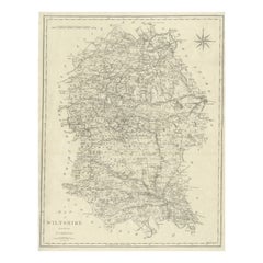
Donald McCulloughWiltshire, original vintage map by Donald McCullough1946
1946
$322.26
£230
€275.53
CA$439.56
A$492.13
CHF 258.04
MX$6,080.56
NOK 3,251.46
SEK 3,069.24
DKK 2,055.76
Shipping
Retrieving quote...The 1stDibs Promise:
Authenticity Guarantee,
Money-Back Guarantee,
24-Hour Cancellation
About the Item
David McCullough
Wiltshire
Lithograph
57 x 43 cm
The Countryman County Map of Wiltshire was part of the Countryman magazine’s series of illustrated county maps, designed to celebrate the unique heritage, geography, and culture of each region. These maps, produced in the mid-20th century, featured charming hand-drawn illustrations of landmarks, historical sites, and rural traditions. This map notably includes illustrations of Stonehenge, Salisbury Cathedral, Lacock Abbey, Malmesbury Abbey, and Wilton House.
- Creator:Donald McCullough
- Creation Year:1946
- Dimensions:Height: 22.45 in (57 cm)Width: 16.93 in (43 cm)
- Medium:
- Movement & Style:
- Period:
- Condition:Small handling mark and couple of isolated spots.
- Gallery Location:London, GB
- Reference Number:1stDibs: LU795315986502
About the Seller
4.8
Platinum Seller
Premium sellers with a 4.7+ rating and 24-hour response times
Established in 2014
1stDibs seller since 2017
345 sales on 1stDibs
Typical response time: <1 hour
- ShippingRetrieving quote...Shipping from: London, United Kingdom
- Return Policy
Authenticity Guarantee
In the unlikely event there’s an issue with an item’s authenticity, contact us within 1 year for a full refund. DetailsMoney-Back Guarantee
If your item is not as described, is damaged in transit, or does not arrive, contact us within 7 days for a full refund. Details24-Hour Cancellation
You have a 24-hour grace period in which to reconsider your purchase, with no questions asked.Vetted Professional Sellers
Our world-class sellers must adhere to strict standards for service and quality, maintaining the integrity of our listings.Price-Match Guarantee
If you find that a seller listed the same item for a lower price elsewhere, we’ll match it.Trusted Global Delivery
Our best-in-class carrier network provides specialized shipping options worldwide, including custom delivery.More From This Seller
View AllOxford, original vintage map by Kerry Lee
By Kerry Lee
Located in London, GB
To see our other original vintage travel posters, scroll down to "More from this Seller" and below it click on "See all from this seller" - or send us a message if you cannot find th...
Category
1960s Realist Landscape Prints
Materials
Lithograph
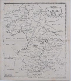
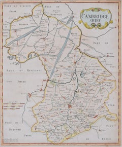
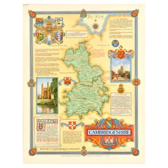
Map of Cambridgeshire, 18th century engraving by Sutton Nicholls
Located in London, GB
To see more, scroll down to "More from this Seller" and below it click on "See all from this Seller."
Sutton Nichols (1668 - 1729)
Map of Cambridgeshire
Engraving
43 x 36 cm
Signe...
Category
18th Century Landscape Prints
Materials
Engraving
John Speede, Map of the County of Surrey, described and divided into hundreds
By John Speed
Located in London, GB
To see our other views and maps of England - including London, Oxford and Cambridge, scroll down to "More from this Seller" and below it click on "See all from this Seller" - or send us a message if you cannot find the view you want.
John Speed/Speede (1551/2-1629)
The County of Surrey Described and Divided into Hundreds
Engraving with later hand colouring and text to the reverse.
Dated to c.1650
36 x 49 cm
Probably the most famous early English mapmaker, John Speed's early life is somewhat of an enigma. He is believed to have trained as a rolling-press printer, but he was at heart an historian granted a sinecure in the Customs House by Queen Elizabeth to indulge his passion, later becoming a Fellow of the Society of Antiquaries. His first maps were historical, of the Holy Land 'Canaan as it was Possessed both in Abraham and Israels Dayes' and of England and Ireland recording 'all their Civill Warres since the Conquest'.
In 1611 he published his 'Hostory of Great Britaine' which he regarded as his magnum opus, but it was the companion atlas 'Theatre of the Empire of Great Britaine' that - as the first printed atlas of Great Britain - sealed his reputation. William Rogers engraved the first map, 'the County Palatine of Chester' in about 1600, but following his untimely death the task of engraving was passed to Jodocus Hondius of Amsterdam.
By 1612 the atlas was complete, the maps famed for their decorative elements. Many have town plans - Britain's first series of such plans - and descriptive text was printed to the reverse until the 1676 edition. Later printings (up until 1770) were issued without this text. By 1627 it has become a part of a world atlas 'Prospect of the Most Famous Parts of the World'. During the 17th century the plates passed through the hands of a series of publishers, the 1676 edition of Thomas Bassett and Richard Chiswell being regarded as its high point with the inclusion for the first time of a series of important maps. For the first half of the eighteenth century they were firmly established in the hands of the Overton family.
This particular edition originally featured in The Theatre Of The Empire Of Great Britaine. It features attractive inset views of the long-since destroyed Richmond...
Category
17th Century Realist Landscape Prints
Materials
Engraving
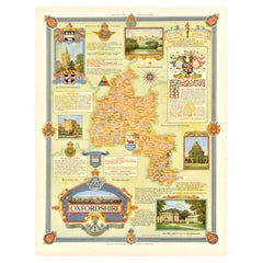
Map of Oxfordshire coloured 18th century engraving by Thomas Kitchin
By Thomas Kitchin
Located in London, GB
To see our other original maps, scroll down to "More from this Seller" and below it click on "See all from this Seller" - or send us a message if you cannot find the poster you want....
Category
1760s Landscape Prints
Materials
Engraving

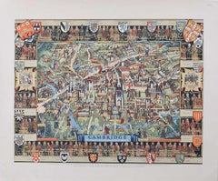
Cambridge Map, Original Vintage Poster by Kerry Lee
By Kerry Lee
Located in London, GB
To see our other original vintage travel posters, scroll down to "More from this Seller" and below it click on "See all from this seller" - or send us a message if you cannot find th...
Category
1940s Realist Landscape Prints
Materials
Lithograph
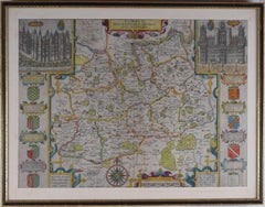
Map of Cambridge 18th century engraving by Sutton Nichols
Located in London, GB
To see more, scroll down to "More from this Seller" and below it click on "See all from this Seller."
Sutton Nichols (1668 - 1729)
Map of Cambridgeshire
Engraving
43 x 36 cm
Signed in plate lower left.
A beautifully coloured 18th century map engraving of Cambridgeshire. The map was produced by Robert Morden for publication in Edward Gibson's 1695 translation of William Camden's Britannia, a topographical and historical survey of Great Britain and Ireland produced to "restore antiquity to Britaine, and Britain to his antiquity" - a most noble aim.
William Camden (1551 - 1623) was an English antiquarian, historian, topographer, and herald, best known as the author of Britannia, the first chorographical survey of the islands of Great Britain and Ireland, and the Annales, the first detailed historical account of the Queen...
Category
18th Century Landscape Prints
Materials
Engraving
You May Also Like
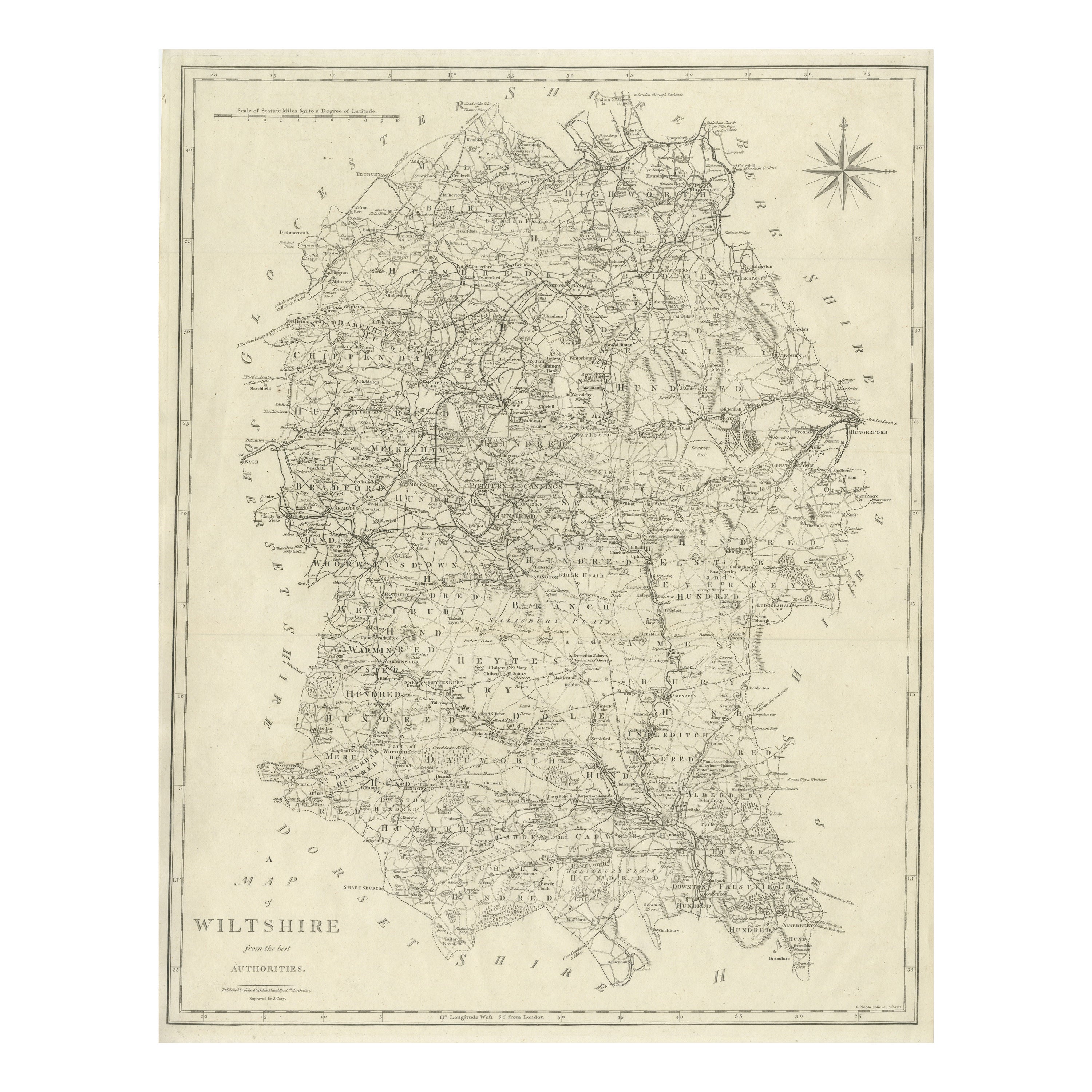
Large Antique County Map of Wiltshire, England, 1805
Located in Langweer, NL
Antique map titled 'A Map of Wiltshire from the best Authorities'. Original old county map of Wiltshire, England. Engraved by John Cary. Originates from 'New British Atlas' by John S...
Category
Antique Early 19th Century Maps
Materials
Paper
Original Vintage Post-World War Two Map Poster Cambridgeshire WWII Ernest Clegg
Located in London, GB
Original vintage post-World War Two map poster for Cambridgeshire England featuring a colourful design by Ernest Costain Clegg (1876-1954) of the ceremonial county with illustrations...
Category
Vintage 1940s British Posters
Materials
Paper
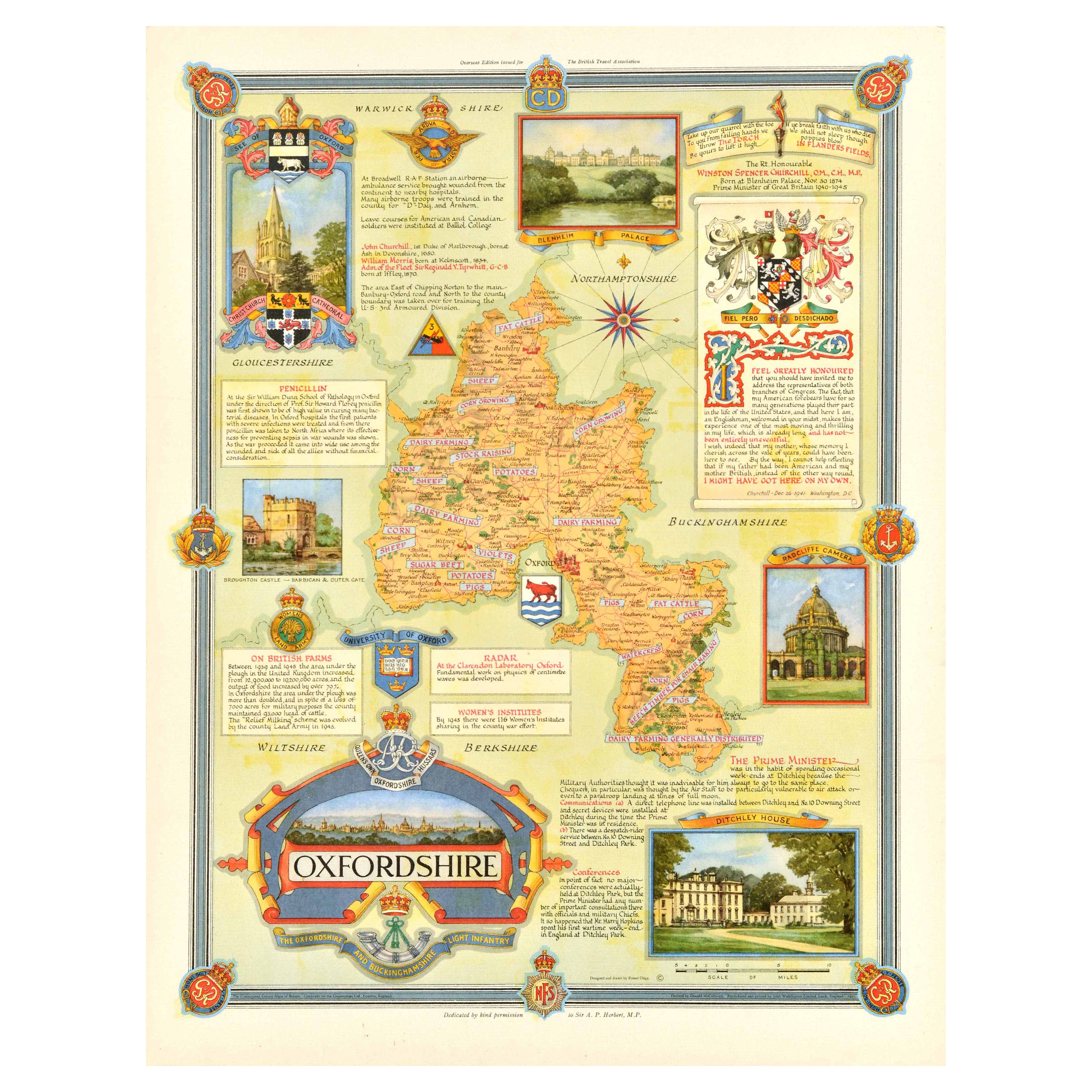
Original Vintage Post-World War Two Map Poster Oxfordshire WWII Ernest Clegg
Located in London, GB
Original vintage post-World War Two map poster for Oxfordshire featuring a colourful design by Ernest Costain Clegg (1876-1954) of the county with illustrations of notable landmarks ...
Category
Vintage 1940s British Posters
Materials
Paper
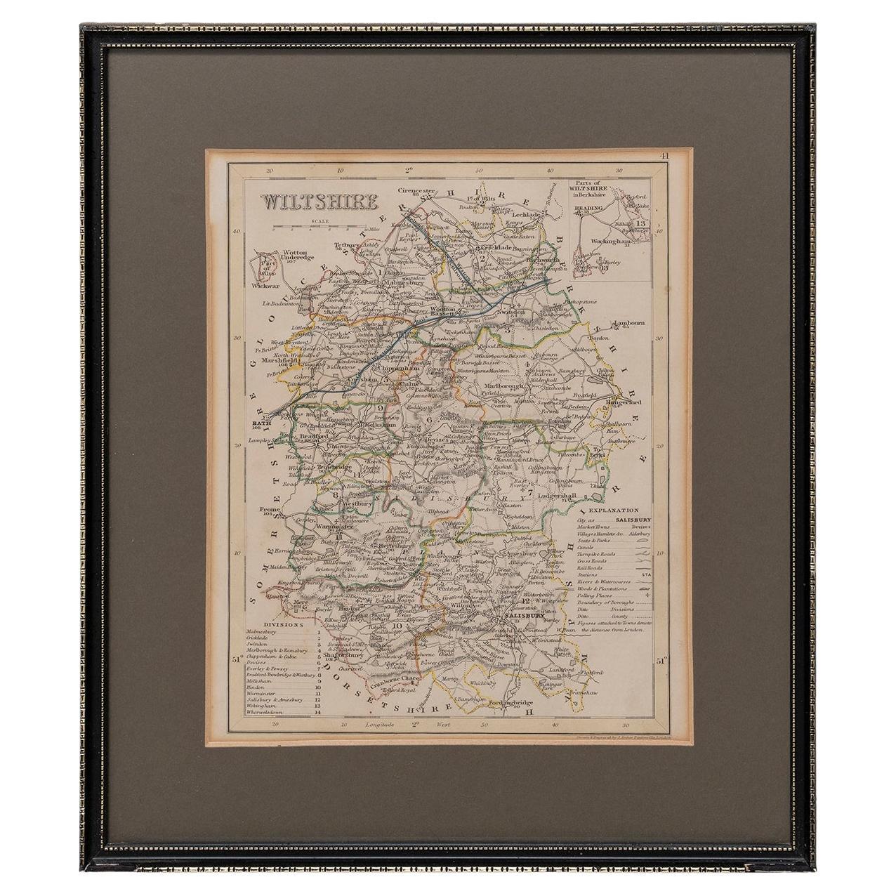
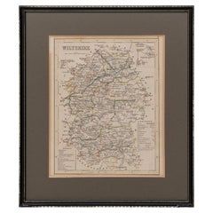
Map Wiltshire Joshua Archer Pentonville London framed 35cm 14" high
Located in BUNGAY, SUFFOLK
Map of Wiltshire Drawn & Engraved by Joshua Archer Pentonville London
Window Parts of Wiltshire in Berkshire
Explanation of Salisbury
County Divisions
Category
Antique 19th Century English Georgian Maps
Materials
Paper
Antique Map of England and Wales by Johnston, 1882
Located in Langweer, NL
Antique map titled 'England and Wales'. Old map of England and Wales, with an inset map of Scilly Islands. This map originates from 'The Royal Atlas of Modern Geography, Exhibiting, ...
Category
Antique 19th Century Maps
Materials
Paper

$136 Sale Price
20% Off
Antique Map of England and Wales by A.K. Johnston, 1865
Located in Langweer, NL
Antique map titled 'England and Wales (Southern Sheet)'. With an inset map of the Scilly Islands. This map originates from the ‘Royal Atlas of Modern Geography’ by Alexander Keith Jo...
Category
Antique Mid-19th Century Maps
Materials
Paper

$262 Sale Price
20% Off