Items Similar to Map of Europe


Want more images or videos?
Request additional images or videos from the seller
1 of 5
Giovanni Maria CassiniMap of Europe1788
1788
$418.42
£312.28
€350
CA$577.18
A$631.34
CHF 332.42
MX$7,537.58
NOK 4,236.72
SEK 3,875.59
DKK 2,666.42
About the Item
Etching hand colored realized by Giovanni Maria Cassini in 1788.
Table from "Nuovo Atlante Geografico Universale", published in Rome in 1788 at Calcografia Camerale.
Very good condition.
- Creator:Giovanni Maria Cassini (Italian)
- Creation Year:1788
- Dimensions:Height: 17.72 in (45 cm)Width: 23.23 in (59 cm)Depth: 0.04 in (1 mm)
- Medium:
- Movement & Style:
- Period:1780-1789
- Framing:Framing Options Available
- Condition:
- Gallery Location:Roma, IT
- Reference Number:Seller: T-1572091stDibs: LU650317072132
About the Seller
4.9
Platinum Seller
Premium sellers with a 4.7+ rating and 24-hour response times
1stDibs seller since 2017
7,865 sales on 1stDibs
Typical response time: 1 hour
- ShippingRetrieving quote...Shipping from: Grasse, France
- Return Policy
More From This Seller
View AllMap of Mar Del Nort - Etching by Johannes Janssonius - 1650s
By Johannes Janssonius
Located in Roma, IT
Antique Map -Mar Del Nort is an antique map realized in 1650 by Johannes Janssonius (1588-1664).
The Map is Hand-colored etching, with coeval watercolorang.
Good conditions with sl...
Category
1650s Modern Figurative Prints
Materials
Etching

Antique Map - Mar Di Athiopia - Etching by Johannes Janssonius - 1650s
By Johannes Janssonius
Located in Roma, IT
Antique Map - Mar Di Athiopia is an antique map realized in 1650 by Johannes Janssonius (1588-1664).
The Map is Hand-colored etching, with coeval watercolorang.
Good conditions wit...
Category
1650s Modern Figurative Prints
Materials
Etching

Ancient Map-Poli Arctici (Map of the Poles)-Etching by Johannes Janssonius-1650s
By Johannes Janssonius
Located in Roma, IT
Poli Arctici is an ancient map realized in 1650 by Johannes Janssonius (1588-1664).
The Map is a Hand-colored etching, with coeval watercoloring.
Good conditions with slight foxing...
Category
1650s Modern Figurative Prints
Materials
Etching

Antique Map - Gallia - Etching by Johannes Janssonius - 1650s
By Johannes Janssonius
Located in Roma, IT
Antique Map - Gallia is an antique map realized in 1650 by Johannes Janssonius (1588-1664).
The Map is Hand-colored etching, with coeval watercoloring.
Good conditions with slight ...
Category
1650s Modern Figurative Prints
Materials
Etching

Map of the War -Vesfaglia and Lower Saxony - Etching - 19th Century
Located in Roma, IT
Map of the War -Vestaglia and Lower Saxony is an etching realized during the 19th century.
Good condition.
Category
Early 19th Century Modern Figurative Prints
Materials
Etching

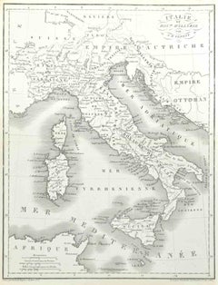
Map of Italy - Etching by Pierre François Tardieu - 1837
Located in Roma, IT
Map of Italy is an Etching realized in 1837.
Good conditions.
The artwork is realized in a well-balanced composition. the artwork and belongs to the suite suite "AtlasBatt" realize...
Category
1830s Modern Figurative Prints
Materials
Lithograph
You May Also Like
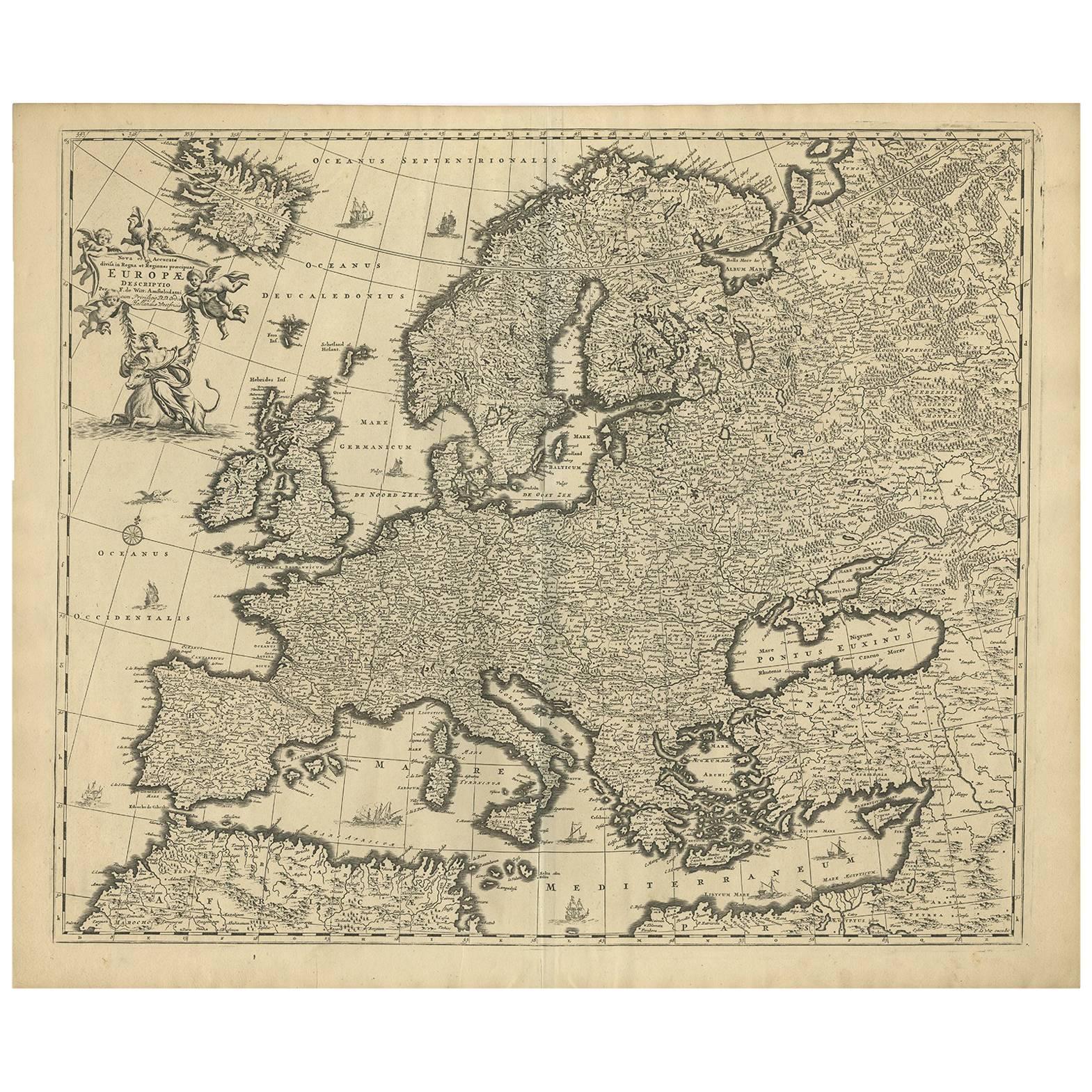
Grand Map of Europe by Frederick de Wit, Circa 1690: A Baroque Era Masterpiece.
Located in Langweer, NL
This is an attractive historical map of Europe created by Frederick de Wit, published around 1690. Here's a detailed description of the map and additional context about its creation:...
Category
Antique Late 17th Century Dutch Maps
Materials
Paper
Antique Map of Europe by Balbi '1847'
Located in Langweer, NL
Antique map titled 'Europe'. Original antique map of Europe. This map originates from 'Abrégé de Géographie (..)' by Adrien Balbi. Published 1847.
Category
Antique Mid-19th Century Maps
Materials
Paper

$143 Sale Price
20% Off
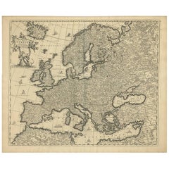
Antique Map of Europe Stretching from Northern Africa to the Baltic Sea, 1719
Located in Langweer, NL
Antique map titled 'Carte de la Germanie et les diferents Etats ou ses Peuples ont porté leurs conquestes'. Original antique map of Europe stretching from northern Africa to the Balt...
Category
Antique 18th Century Maps
Materials
Paper

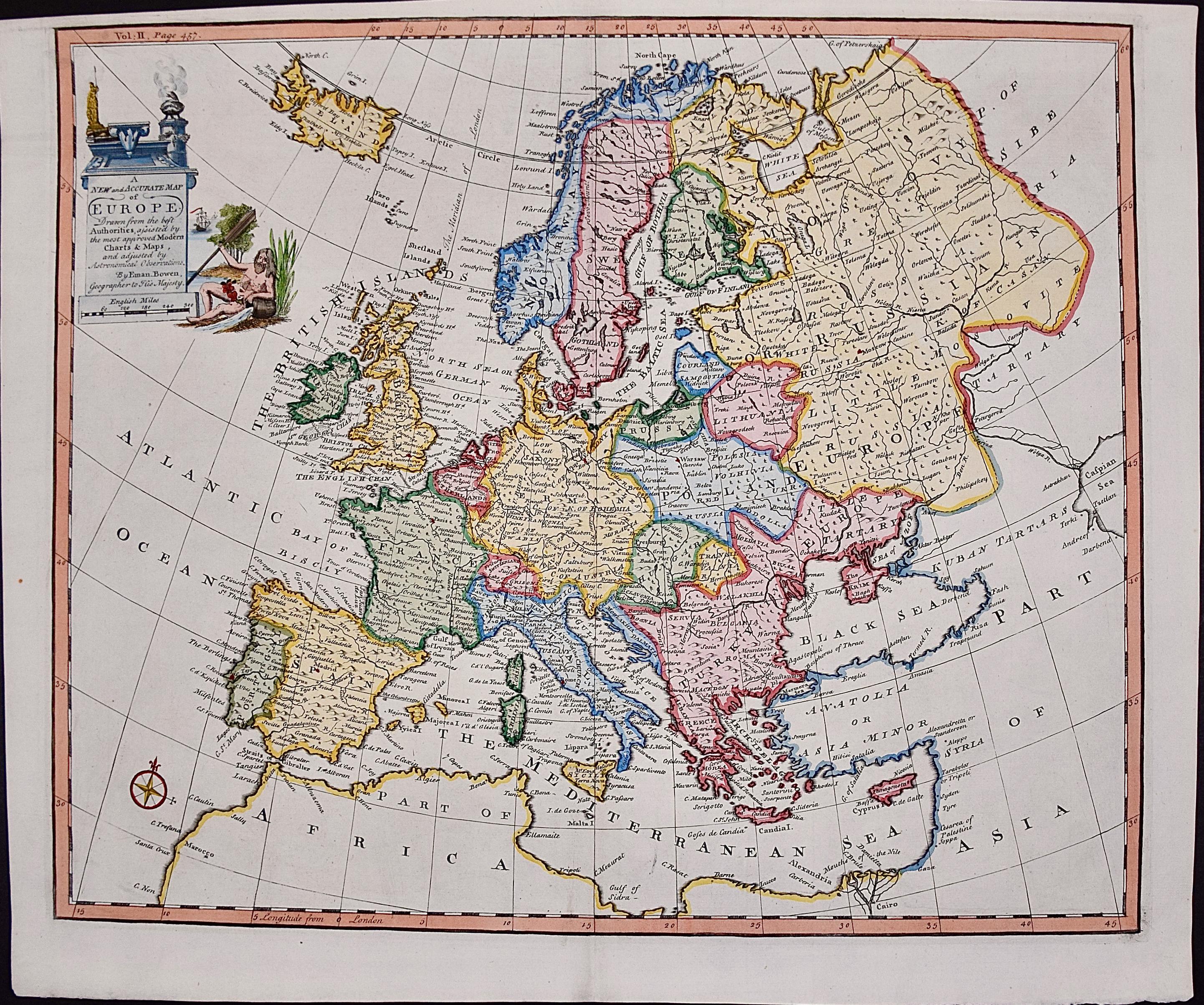
Europe: An Original 18th Century Hand-colored Map by E. Bowen
Located in Alamo, CA
This is an original 18th century hand-colored map entitled "A New & Accurate Map of Europe Drawn from the Best Authorities Assisted by the Most Improved Modern Charts and Maps." by E...
Category
Mid-18th Century Old Masters Landscape Prints
Materials
Engraving

$940 Sale Price
20% Off
Antique Map of Europe by R. Bonne, 1780
Located in Langweer, NL
A fine example of Rigobert Bonne and Guilleme Raynal’s 1780 map of Europe. Drawn by R. Bonne for G. Raynal’s Atlas de Toutes les Parties Connues du Globe Terrestre, Dressé pour l'His...
Category
Antique Late 18th Century French Maps
Materials
Paper

$150 Sale Price
30% Off
Antique Map of Europe by Keizer & de Lat, 1788
Located in Langweer, NL
Antique map titled 'Kaartje van Europa (..)'. Uncommon original antique map of Europe. This map originates from 'Nieuwe Natuur- Geschied- en Handelkundige Zak- en Reisatlas' by Gerri...
Category
Antique Late 18th Century Maps
Materials
Paper

$382 Sale Price
20% Off