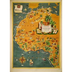
Items Similar to Original map poster by G. Carriat Rolant for AOF (Afrique Occidentale Française)


Want more images or videos?
Request additional images or videos from the seller
1 of 7
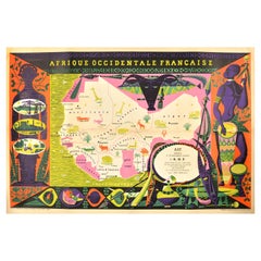
G. Carriat-RolantOriginal map poster by G. Carriat Rolant for AOF (Afrique Occidentale Française)Circa 1950
Circa 1950
$2,735.94
£2,038.36
€2,300
CA$3,838.50
A$4,217.41
CHF 2,174.89
MX$50,528.84
NOK 27,614.43
SEK 25,915.02
DKK 17,521.33
About the Item
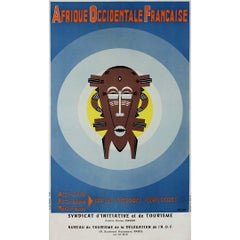
The circa 1950 original map poster by G. Carriat Rolant for AOF (Afrique Occidentale Française) is a notable example of mid-20th-century cartographic art and colonial-era representation. Numbered 584 out of 1000, this limited-edition piece was edited by Paul Bory in Casablanca, showcasing the unique blend of artistic and geopolitical influences of the time.
During this period, French West Africa (AOF) was a federation of eight French colonial territories in Africa. Posters and maps like this one served both practical and propagandistic purposes, promoting the French colonial presence and the supposed benefits of the empire. The map likely emphasized the vast expanse of the AOF, which included present-day countries such as Senegal, Mali, Niger, and Ivory Coast, among others.
G. Carriat Rolant’s work is indicative of the stylistic approach to mapmaking at the time, combining artistic detail with geographic precision. These maps were not just tools for navigation but also symbols of authority, often commissioned to reflect the grandeur and reach of colonial empires.
Edited by Paul Bory in Casablanca, this map poster would have been part of a series aimed at an audience interested in the geopolitics of Africa and the French colonial enterprise. The fact that it was a numbered edition adds to its rarity and historical significance, making it a collector’s item today. It is a reflection of the mid-century fascination with exploration and control, capturing a moment in history when maps were powerful symbols of territorial ambition.
Map - Africa
Numbered 584/1000
Paul Bory Casablanca
- Creator:G. Carriat-Rolant
- Creation Year:Circa 1950
- Dimensions:Height: 29.53 in (75 cm)Width: 40.95 in (104 cm)
- Medium:
- Period:
- Condition:Good condition, small tears on the edges.
- Gallery Location:PARIS, FR
- Reference Number:1stDibs: LU1792215073602
About the Seller
5.0
Gold Seller
Premium sellers maintaining a 4.3+ rating and 24-hour response times
Established in 2021
1stDibs seller since 2022
183 sales on 1stDibs
Typical response time: 1 hour
- ShippingRetrieving quote...Shipping from: PARIS, France
- Return Policy
Authenticity Guarantee
In the unlikely event there’s an issue with an item’s authenticity, contact us within 1 year for a full refund. DetailsMoney-Back Guarantee
If your item is not as described, is damaged in transit, or does not arrive, contact us within 7 days for a full refund. Details24-Hour Cancellation
You have a 24-hour grace period in which to reconsider your purchase, with no questions asked.Vetted Professional Sellers
Our world-class sellers must adhere to strict standards for service and quality, maintaining the integrity of our listings.Price-Match Guarantee
If you find that a seller listed the same item for a lower price elsewhere, we’ll match it.Trusted Global Delivery
Our best-in-class carrier network provides specialized shipping options worldwide, including custom delivery.More From This Seller
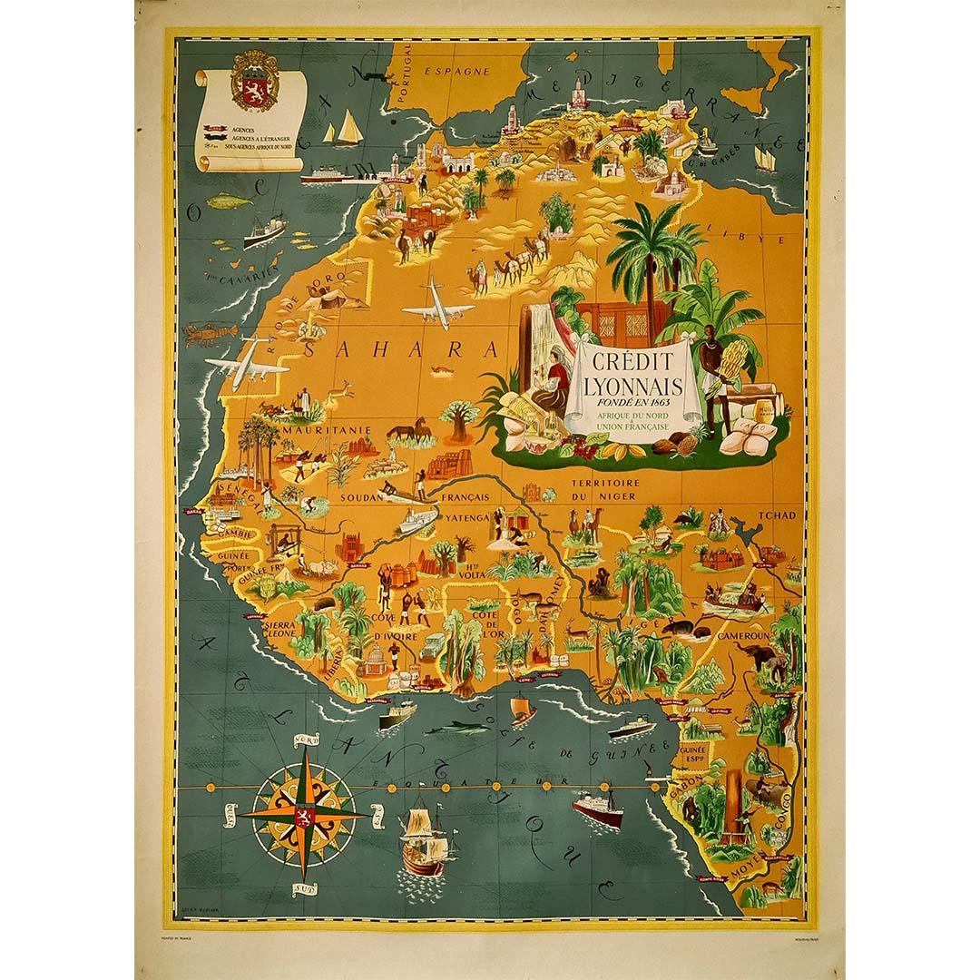
View All1939 original map Lucien Boucher Crédit Lyonnais Afrique Du Nord Union Française
By Lucien Boucher
Located in PARIS, FR
The 1939 original map by Lucien Boucher, commissioned by Crédit Lyonnais, is a remarkable piece of cartographic art that highlights the regions of North Africa within the French Unio...
Category
1930s Prints and Multiples
Materials
Paper, Lithograph
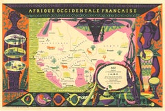
Circa 1930 original travel poster for The AOF (Afrique-Occidentale Française)
Located in PARIS, FR
The AOF (Afrique-Occidentale Française) was a general government that brought together eight French colonies in West Africa in a federation between 1895 and 1958.
It was formed in s...
Category
Mid-20th Century Prints and Multiples
Materials
Lithograph, Paper, Linen
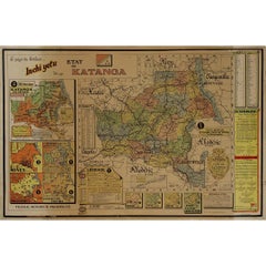
Original 1960 Map by Louis Dressen État du Katanga Congo
Located in PARIS, FR
This original 1960 poster by Louis Dressen, titled État du Katanga, is a rare and powerful visual document from one of the most turbulent moments in post-colonial African history. Pu...
Category
1960s Prints and Multiples
Materials
Paper, Lithograph
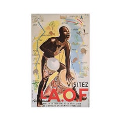
1951 original travel poster "Afrique Occidentale Française" by Charlas
Located in PARIS, FR
The 1951 original travel poster "Afrique Occidentale Française" by Charlas was designed to promote tourism in French West Africa, showcasing the region as an attractive, picturesque,...
Category
1950s Prints and Multiples
Materials
Paper, Lithograph, Linen
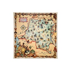
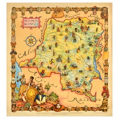
Original map of the Belgian Congo illustrated by James Thiriar in 1954
Located in PARIS, FR
Beautiful map of the Belgian Congo illustrated by James Thiriar in 1954. James Thiriar, born in Ixelles in 1889 and died in Brussels in 1965, was a Belgi...
Category
1950s Prints and Multiples
Materials
Paper, Lithograph, Linen
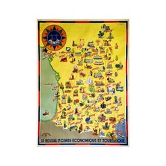
Circa 1935 map illustrated by André Giroux of the P.O Midi railroad network.
Located in PARIS, FR
Very beautiful map illustrated by André Giroux of the P.O Midi railroad network.
The railway company from Paris to Orleans and the Midi (PO Midi) is the n...
Category
1930s Prints and Multiples
Materials
Paper, Lithograph, Linen
You May Also Like
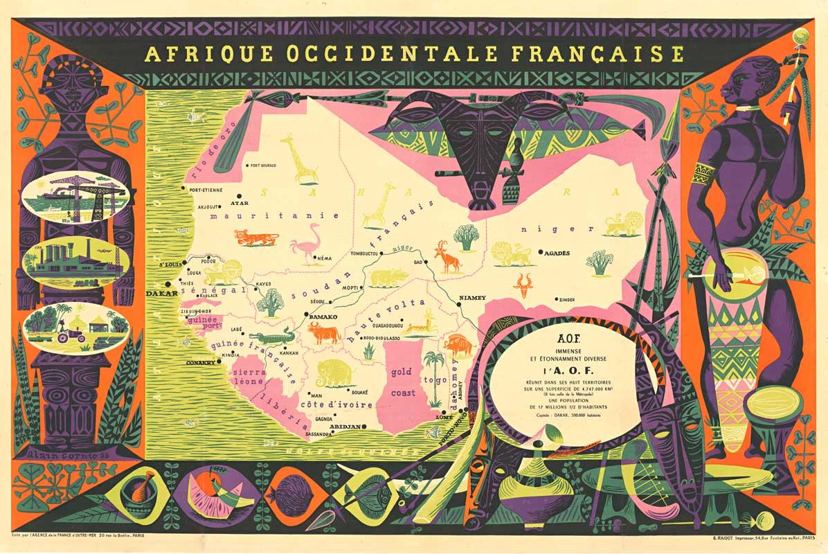
Original Vintage Poster French West Africa Map Afrique Occidentale Francaise Art
By alain cornic
Located in London, GB
Original vintage poster featuring an illustrated map of French West Africa / Afrique Occidentale Francaise marking the capital cities, towns, ports, Sahara Desert and rivers in Mauri...
Category
Vintage 1950s French Posters
Materials
Paper
Original Afrique Occidentale - Africa horizontal vintage poster
Located in Spokane, WA
Original linen-backed horizontal format vintage poster "AFRIQUE OCCIDENTALE FRANCAISE" lithograph. Poster for French West Africa Agency France d'Outre-Mer 1955.
The poster has vignettes showing some African agriculture, oil along one side, local fruits and foods along the bottom, and stylized statues on left and right, harps, clay pots, drums with the maps of West Africa map...
Category
1950s Land Landscape Prints
Materials
Lithograph
Original Vintage Travel Map Poster Belgian Congo Africa Thiriar Margraff Belgium
Located in London, GB
Original vintage travel map poster for the Belgian Congo / Belgisch Kongo featuring a pictorial map of the area bordering Equatorial Africa, French Sudan, ...
Category
Vintage 1940s Belgian Posters
Materials
Paper
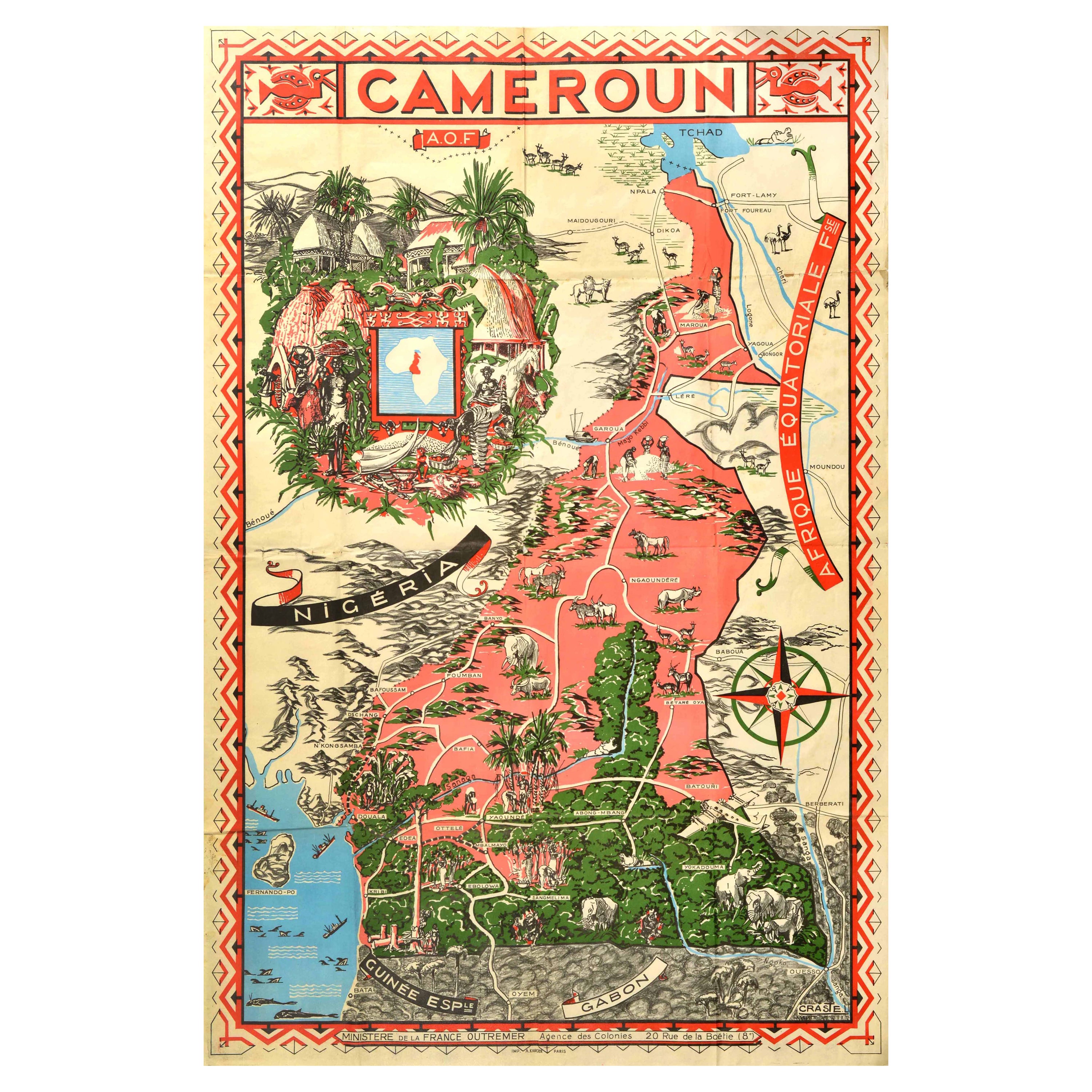
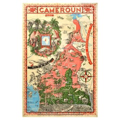
Original Vintage Illustrated Map Poster Afrique Equatoriale Francaise Cameroon
Located in London, GB
Original vintage illustrated map poster for Cameroun AOF Afrique Occidentale Francaise / Cameroon French West Africa showing the Central African country of ...
Category
Vintage 1950s French Posters
Materials
Paper
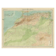
Antique Map of Northwest Africa by Bartholomew, 1922
Located in Langweer, NL
Antique map of Africa titled 'North-West Africa'. Old map of north-west Africa depicting Morocco, Algeria, Tunis and surroundings. This map originates from 'The Times' atlas. Artists...
Category
20th Century Maps
Materials
Paper
$90 Sale Price
20% Off
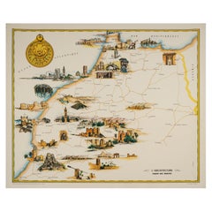
Gayraud, Original Vintage Poster, Morocco Map, Royal Air Maroc, Essaouira, 1950
Located in SAINT-OUEN-SUR-SEINE, FR
Poster created by the artist Gayraud around 1950 and published by Royal Air Maroc to promote tourism in Morocco.
Artist: Gayraud M.
Title: L’architecture – Royal Air Maroc
Date: c...
Category
Vintage 1950s French Mid-Century Modern Posters
Materials
Paper
More Ways To Browse
Africa Colonial
Vintage African Map
Casablanca Poster
Colonial Africa Poster
Altman Artist
Andy Warhol Exhibition Poster
Antique Farm Prints
Antonio Saura
Astronomy Print
Banksy Poster
Bonjour Vintage
Boulanger Lithograph
British Linocuts
By Mark Drew
Cape Of Good Hope Art
Carriage Engraving
Charles Bragg Lithographs
Claude Le Lorrain