Items Similar to 1950 original map by Garcia Fuentes Manuel - Sevilla Perspectiva General

Want more images or videos?
Request additional images or videos from the seller
1 of 8
Garcia Fuentes Manuel1950 original map by Garcia Fuentes Manuel - Sevilla Perspectiva General1950
1950
$594.66
£445.24
€500
CA$831.69
A$906.46
CHF 472.05
MX$10,937.16
NOK 5,933.80
SEK 5,570.46
DKK 3,809.05
About the Item
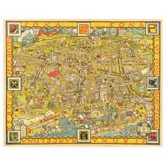
The 1950 original map by Garcia Fuentes Manuel, titled "Sevilla Perspectiva General," offers a comprehensive and detailed overview of Seville as it stood in the mid-20th century, showcasing the city's intricate layout and prominent landmarks. Garcia Fuentes Manuel, a skilled draftsman specializing in public works, displayed his expertise in this map, capturing the essence of urban landscapes with precision and artistry.
Created during a period of post-war recovery and modernization in Spain, the map reflects Seville's status as a vital cultural and economic center. The 1950s were marked by significant urban development and infrastructural improvements, and this map serves as a historical document, providing insight into the urban planning and architectural landscape of the time.
The map presents a bird's-eye view of Seville, intricately detailing its streets, buildings, and notable landmarks, including essential sites such as the Cathedral of Seville, the Alcázar, and the Plaza de España. The Guadalquivir River, a critical geographical feature of the city, is prominently depicted, illustrating its significance in Seville's history and development.
Garcia Fuentes Manuel's map is not only a practical tool but also an artistic piece. The decorative border, compass rose, and careful color selection add an aesthetic quality that enhances its visual appeal. The map balances accuracy with artistic flair, making it both informative and beautiful.
Seville, known for its rich cultural heritage, vibrant festivals, and historical architecture, is vividly brought to life through this map. It serves as a snapshot of the city's past, capturing the layout and landmarks that define Seville's unique character. For historians, urban planners, and art collectors, this map is a valuable artifact that offers a glimpse into the city's mid-20th century state.
The 1950 original map "Sevilla Perspectiva General" by Garcia Fuentes Manuel is a testament to the artistry and precision of public works draftsmen of the time. It provides a detailed and aesthetically pleasing depiction of Seville, reflecting the city's historical and cultural significance. This map remains a cherished piece for those interested in the history of Seville and the evolution of its urban landscape.
Illustrated document
Card - Tourism - Spain
Por El Delineante de Obras Publics - Platur
- Creator:Garcia Fuentes Manuel
- Creation Year:1950
- Dimensions:Height: 18.9 in (48 cm)Width: 27.17 in (69 cm)
- Medium:
- Period:
- Condition:Very good condition, on linen.
- Gallery Location:PARIS, FR
- Reference Number:1stDibs: LU1792214709172
About the Seller
5.0
Gold Seller
Premium sellers maintaining a 4.3+ rating and 24-hour response times
Established in 2021
1stDibs seller since 2022
186 sales on 1stDibs
Typical response time: 1 hour
- ShippingRetrieving quote...Shipping from: PARIS, France
- Return Policy
Authenticity Guarantee
In the unlikely event there’s an issue with an item’s authenticity, contact us within 1 year for a full refund. DetailsMoney-Back Guarantee
If your item is not as described, is damaged in transit, or does not arrive, contact us within 7 days for a full refund. Details24-Hour Cancellation
You have a 24-hour grace period in which to reconsider your purchase, with no questions asked.Vetted Professional Sellers
Our world-class sellers must adhere to strict standards for service and quality, maintaining the integrity of our listings.Price-Match Guarantee
If you find that a seller listed the same item for a lower price elsewhere, we’ll match it.Trusted Global Delivery
Our best-in-class carrier network provides specialized shipping options worldwide, including custom delivery.More From This Seller
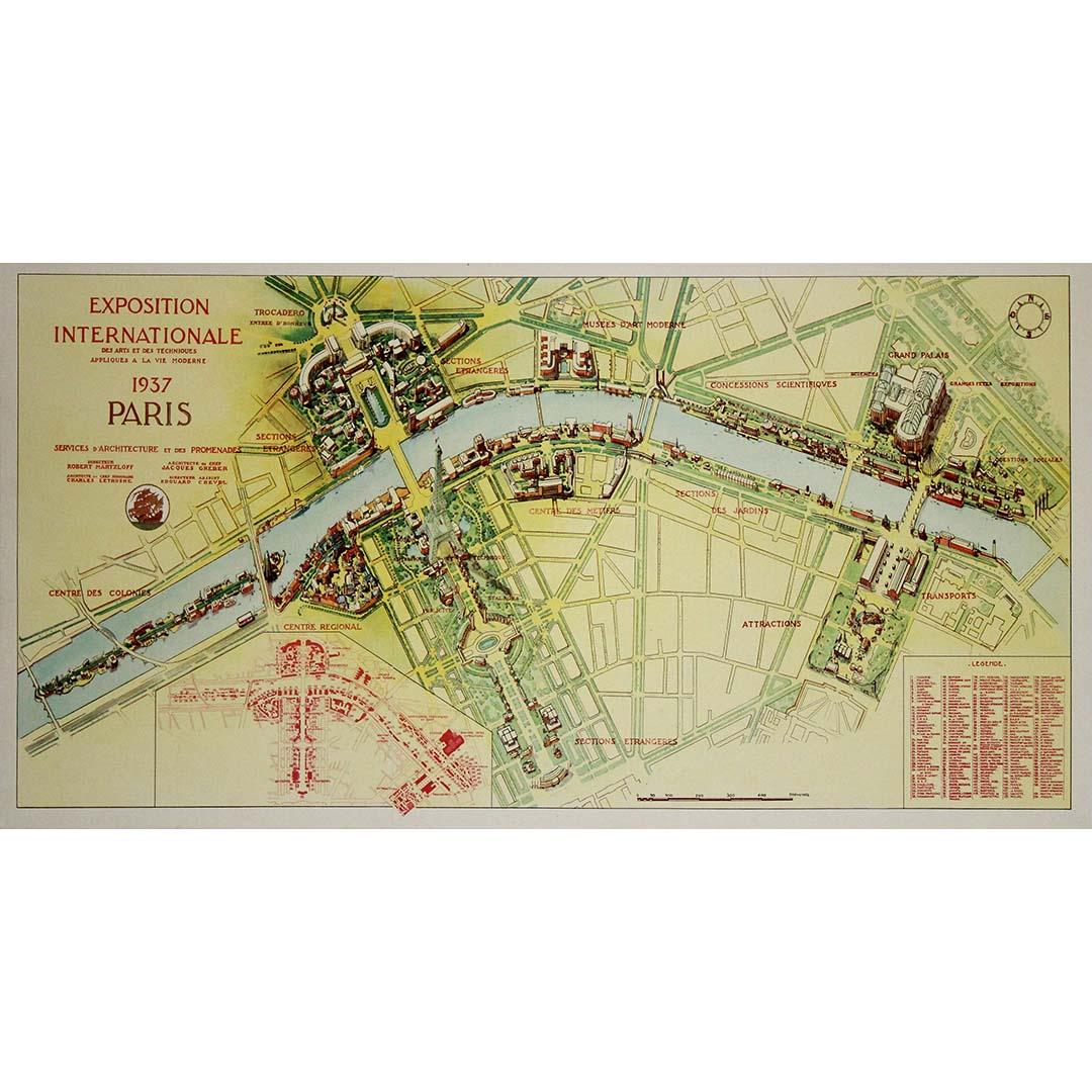
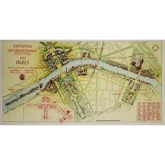
View All1937 original poster illustrated map of the Exposition Internationale
Located in PARIS, FR
This 1937 original poster presents a detailed illustrated map of the Exposition Internationale des Arts et Techniques dans la Vie Moderne, held in Paris. The International Exposition...
Category
1930s Prints and Multiples
Materials
Linen, Paper, Lithograph
Circa 1950 original illustrated map for "Carte France autour de Bordeaux"
Located in PARIS, FR
The circa 1950 original illustrated map for "Carte France autour de Bordeaux" is an excellent representation of mid-20th century cartography, focusing on the area surrounding Bordeau...
Category
1950s Prints and Multiples
Materials
Paper, Linen
1947 original map Gouvernement Généraux du Poitou, du Pays d'Aunis
Located in PARIS, FR
The 1947 original map Gouvernement Généraux du Poitou, du Pays d'Aunis et de Saintonge Angoumois, created by Louis Larmat and printed by Dorel in Paris, is a beautifully detailed cartographic representation of a historically significant region in western France. This map, part of Larmat’s extensive body of work, is known for its artistic craftsmanship and geographical precision, offering a comprehensive view of the historical administrative regions of Poitou, Aunis, Saintonge, and Angoumois, which played key roles in the political and cultural history of France.
Louis Larmat is celebrated for his contributions to cartography, particularly for his ability to merge historical context, topographical detail, and aesthetic elegance in his maps. His works, especially those focusing on the vinicultural regions of France, are highly respected for their accuracy and artistry. This particular map, although focusing on a more political and historical aspect rather than the wine regions he is most famous for, continues his tradition of detailed regional documentation. Larmat’s cartographic works often transcended the realm of simple geographical depiction, becoming historical documents that encapsulate the cultural essence of the regions they portray.
This map illustrates the general governments (administrative divisions) of the provinces of Poitou, Aunis, Saintonge, and Angoumois, regions that are steeped in history. These areas, situated along France’s western coastline, have been integral to the country’s political, economic, and cultural development over centuries. The region of Poitou, for example, is historically known as the birthplace of Eleanor of Aquitaine...
Category
1940s Prints and Multiples
Materials
Lithograph, Paper

1949 poster by Ruiz Sanchez Braulio Sevilla Feria de Abril Fiestas Primavera
Located in PARIS, FR
Poster in lithography by Braulio RUIZ SÁNCHEZ 🇪🇸 (1911-1967) promoting the traditional "Feria de Abril" through typical elements of local folklore: a guitarist sitting leaning on h...
Category
1940s Prints and Multiples
Materials
Paper, Linen, Lithograph

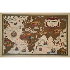
1939 original map for Air France titled "Nova et Vetera" by Lucien Boucher
By Lucien Boucher
Located in PARIS, FR
In 1939, Lucien Boucher, a renowned French artist and illustrator, created a captivating map for Air France titled "Nova et Vetera", which translates to "New and Old" in Latin. This original lithographic poster is a remarkable fusion of vintage cartographic art and modern aviation, crafted as a promotional piece for the airline. It beautifully symbolizes the connection between the historic routes of exploration and the new ones made possible by air travel.
Boucher was celebrated for his unique ability to combine the romanticism of classic maps with the sleek, modern spirit of 20th-century flight. Among his series of illustrated maps for Air France, "Nova et Vetera" stands out with its nostalgic allure and references to history.
The map exudes the charm of the age of exploration, echoing the style of 16th- and 17th-century cartographers. Rendered in rich, earthy tones, it depicts brown continents framed by pale blue oceans, evoking the feel of antique navigational...
Category
1930s Prints and Multiples
Materials
Lithograph, Paper, Linen
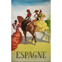
Circa 1950 original travel poster by Morell showcasing Spain
Located in PARIS, FR
The circa 1950 original travel poster by Morell showcasing Spain, with its depiction of cavaliers, captures the essence of adventure and romance synonymous with travel to this vibran...
Category
1950s Prints and Multiples
Materials
Linen, Paper, Lithograph
You May Also Like
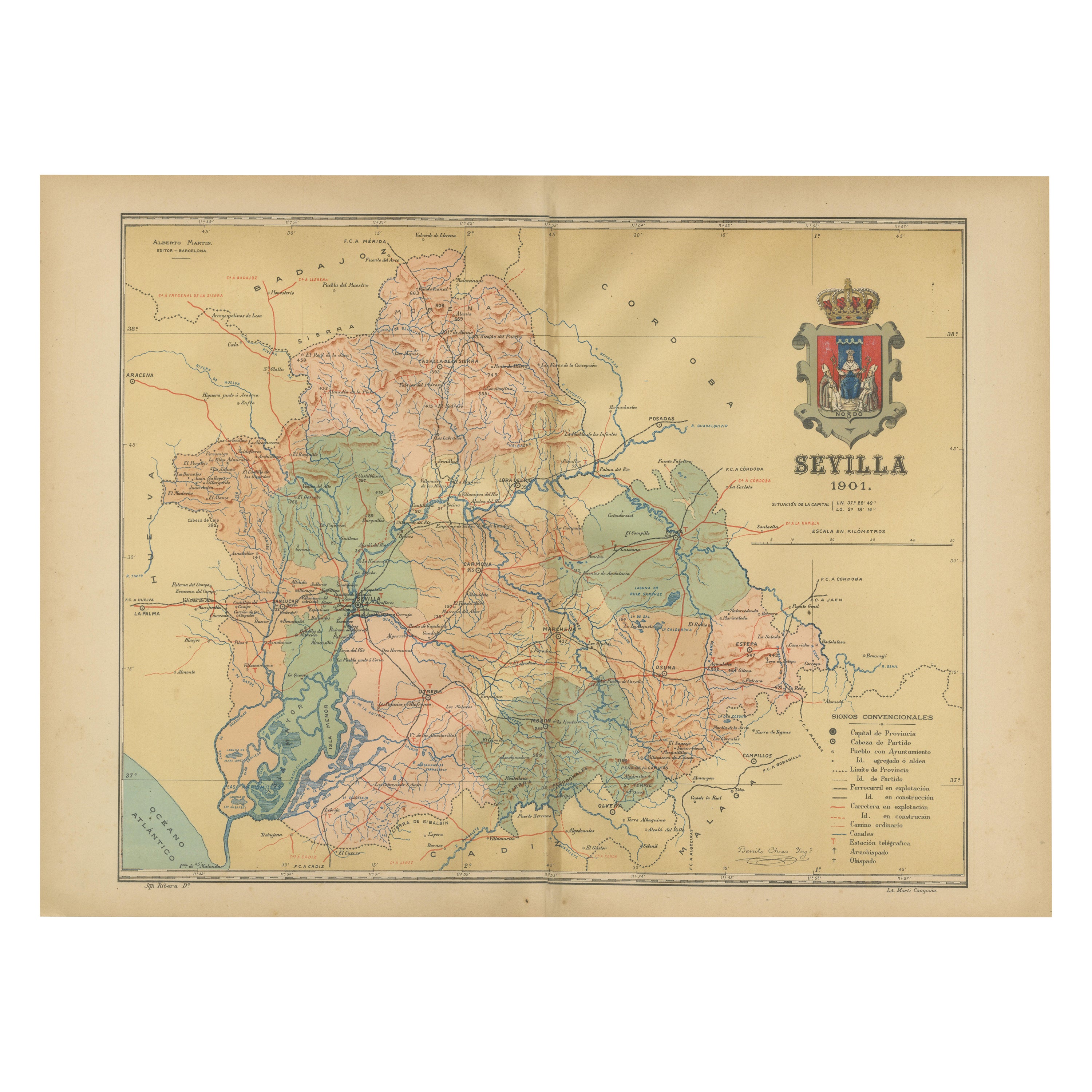
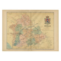
Map of Sevilla Province, 1901: A Depiction of The Spanish Cultural Heartland
Located in Langweer, NL
The print for sale here depicts a historical map of the province of Sevilla (Seville) from the year 1901. Sevilla is located in the southern part of Spain and is part of the autonomo...
Category
Antique Early 1900s Maps
Materials
Paper
$266 Sale Price
30% Off
Free Shipping
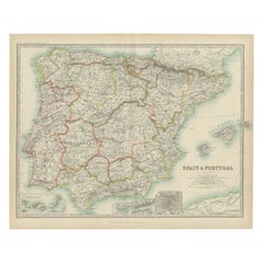
Large Original Vintage Map of Spain, circa 1920
Located in St Annes, Lancashire
Great map of Spain
Original color.
Good condition
Published by Alexander Gross
Unframed.
Category
Vintage 1920s English Maps
Materials
Paper

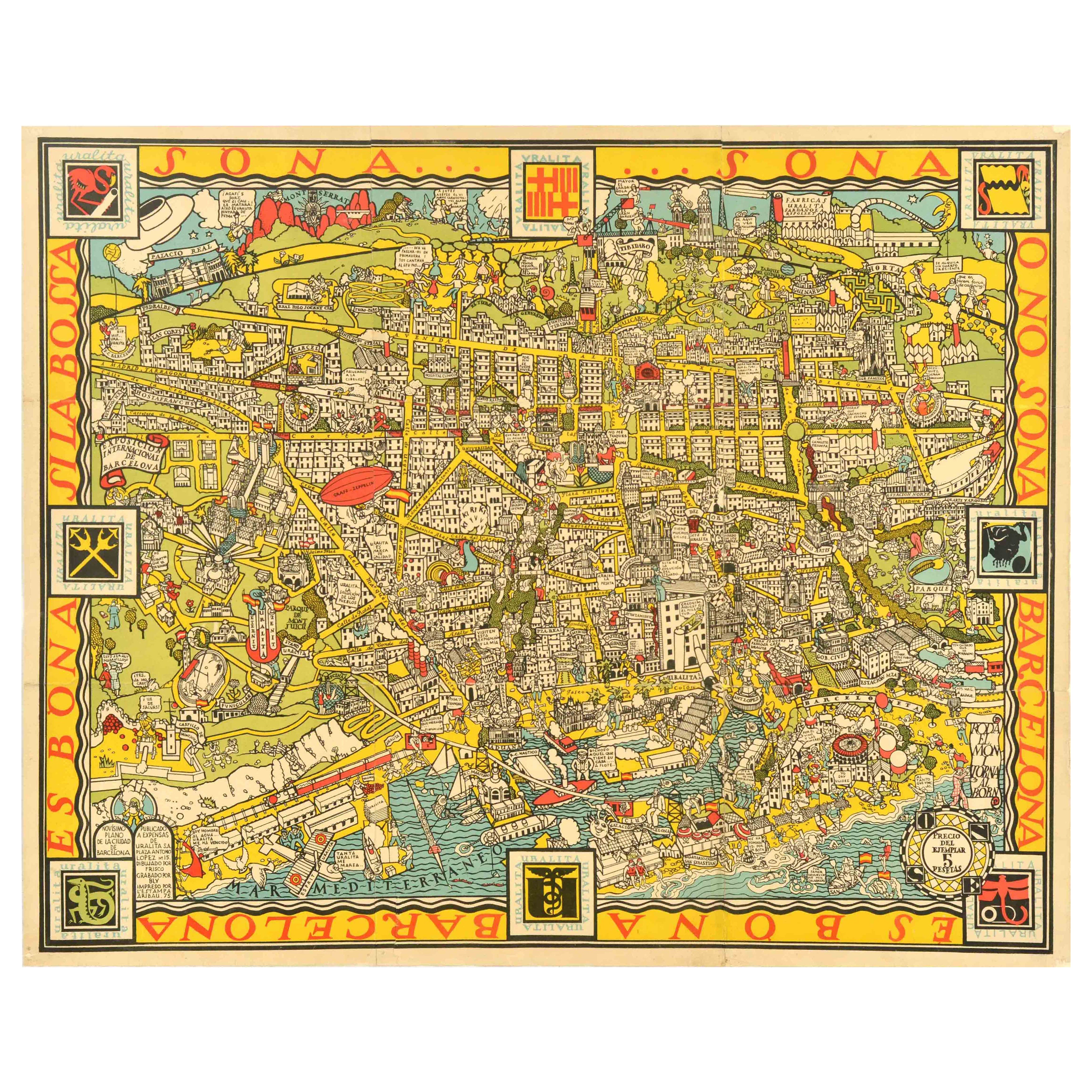
Original Vintage Travel Map Poster Barcelona Map International Exposition Spain
Located in London, GB
Original vintage map poster for Barcelona Spain issued for the International Exposition of Barcelona held on Montjuic hill from 20 May 1929 to 15 January 1930 - Exposicion Internacio...
Category
Vintage 1920s Spanish Posters
Materials
Paper
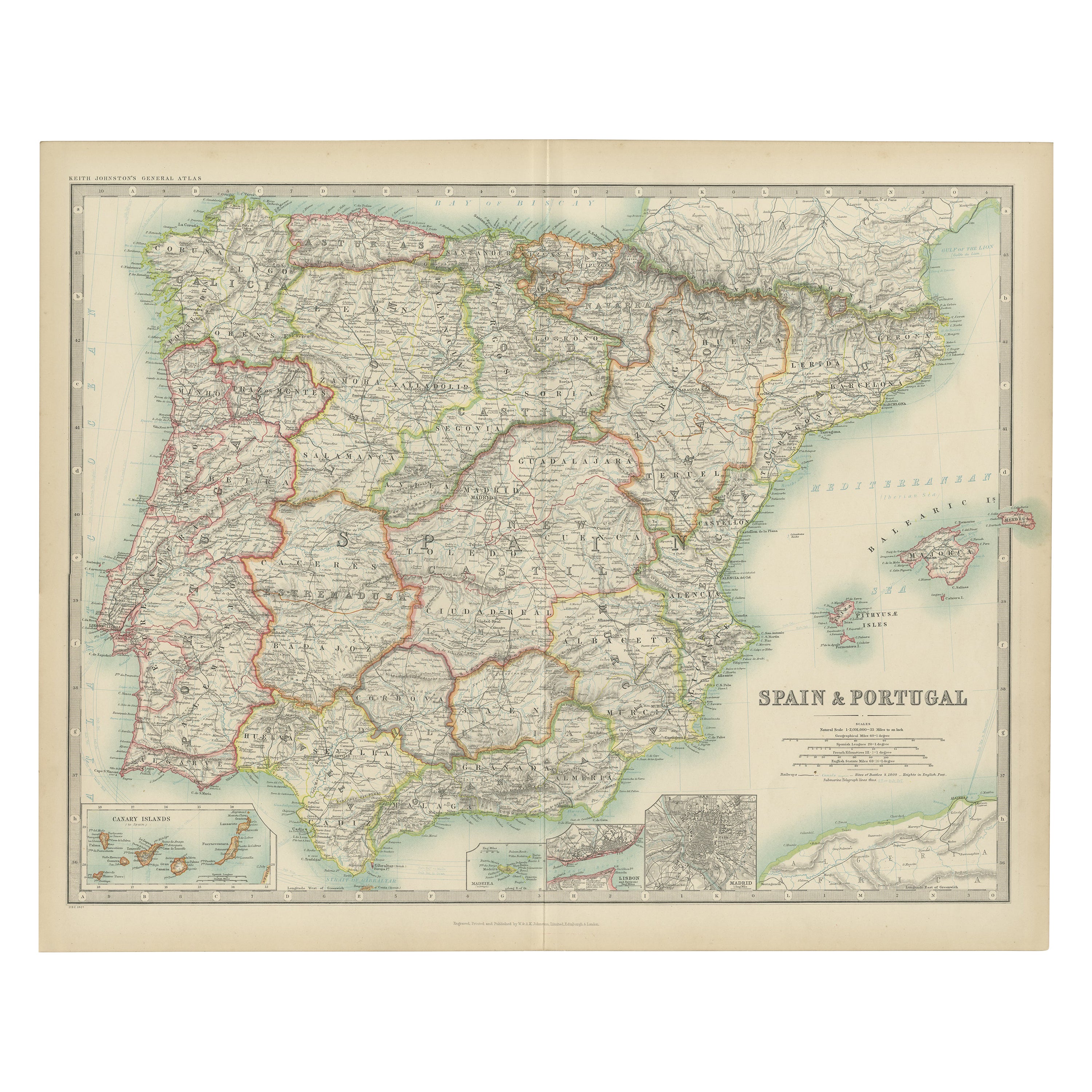
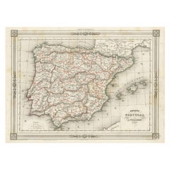
Antique Map of Spain and Portugal by Johnston, '1909'
Located in Langweer, NL
Antique map titled 'Spain and Portugal'. Original antique map of Spain and Portugal. With inset maps of the Canary Islands, Madeira, Lisbon and Ma...
Category
Early 20th Century Maps
Materials
Paper
$237 Sale Price
20% Off
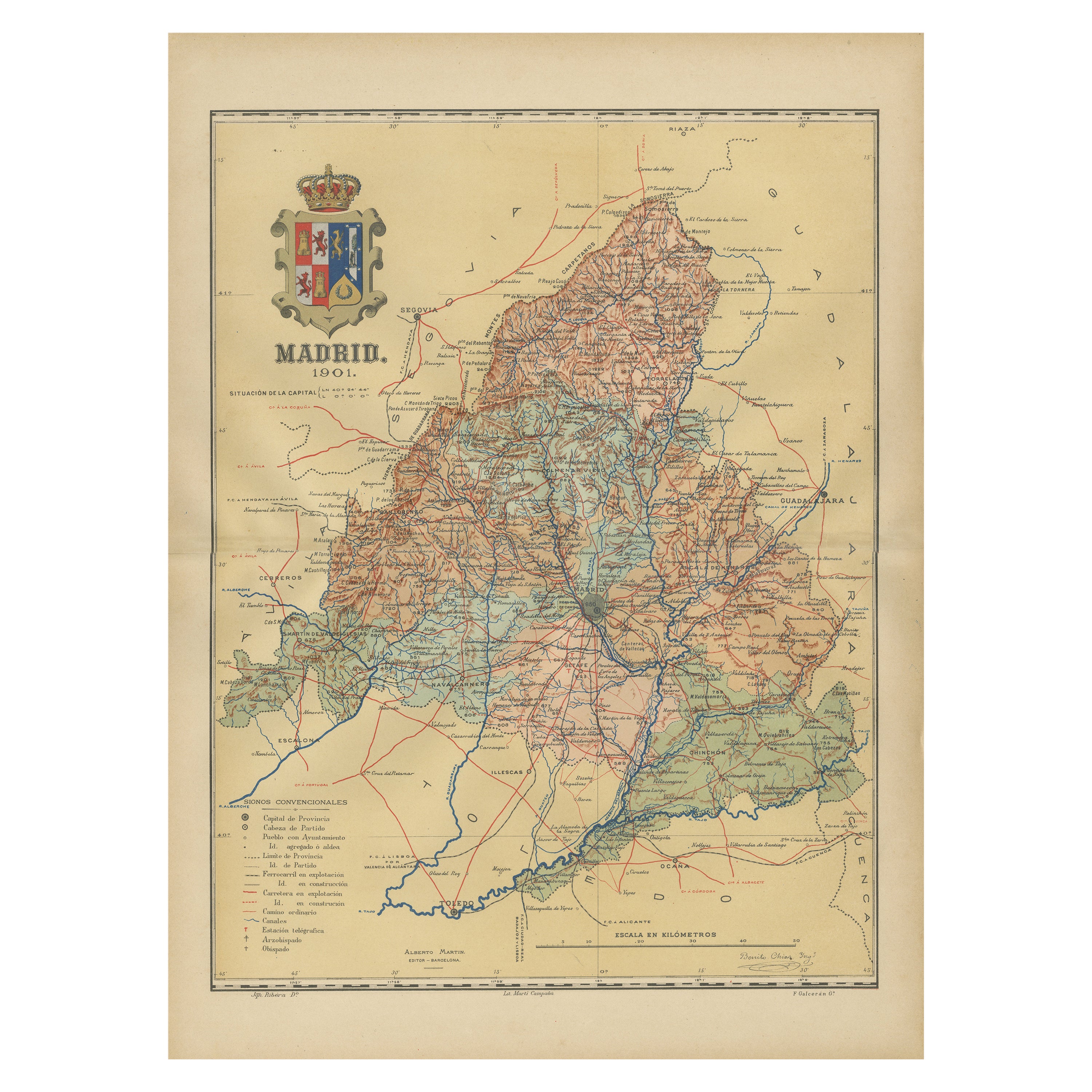
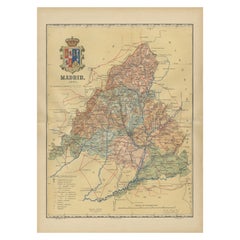
Madrid 1901: A Historical Map of Spain's Capital Province
Located in Langweer, NL
The map is of the province of Madrid, the capital region of Spain, as it appeared in 1901. Here are the key features it displays:
The map shows the central part of Spain, with the Guadarrama mountain range prominently visible, marking the natural border to the north of Madrid.
Blue lines likely indicate rivers, including the Manzanares River, which flows through Madrid, and the Jarama River, a tributary to the Tagus.
Red lines depict the roads and railways, outlining the infrastructure that connects Madrid's various towns and cities within the province and beyond.
Symbols and labels mark the locations of cities, towns, and villages, with Madrid itself likely being the focal point. Dotted lines may represent the administrative divisions within the province. The map includes a legend (Signos Convencionales) that explains the symbols used for provincial capitals, roads, railways, and other geographic features.
The coat of arms of Madrid, featuring a bear and a strawberry tree (madroño), is prominently featured, symbolizing the city's and the province's historical coat of arms.
About the province of Madrid:
Madrid is not only the capital of Spain but also the heart of the Iberian Peninsula, both geographically and politically. The city is renowned for its rich repositories of European art, including the Prado Museum's works by Goya, Velázquez, and other Spanish masters. The province of Madrid is characterized by a blend of historical and modern elements, with a rich cultural life that includes theater, opera, and flamenco, as well as gastronomy that features a mix of traditional Spanish dishes and international cuisine...
Category
Antique Early 1900s Maps
Materials
Paper
Antique Map of Spain and Portugal, with Frame Style Border
Located in Langweer, NL
Antique map titled 'Espagne et Portugal'. Attractive map of Spain and Portugal. The map covers all of Spain and Portugal from France to the Mediterranean Sea and includes the Baleari...
Category
Antique Mid-19th Century Maps
Materials
Paper
$114 Sale Price
20% Off
More Ways To Browse
Vintage State Maps
Abstract 3d Wooden Wall Sculpture
Alex Katz Red
Antique Black Forest Wood Picture
Antique Pink Botanical Prints
Antique Sailing Prints
Bernardino Nocchi
Betye Saar
Buste De Femme
Canterbury Tales
Carlos Almaraz
Cccp Poster
Chagall Bible Etchings
Cold War Propaganda
Degas Etching
Disney Lobby Card
F1 Art
Felix The Cat