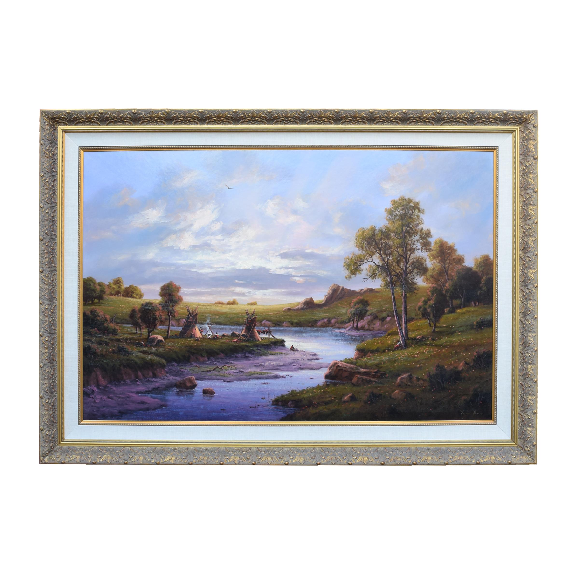
Items Similar to Native American Camp by a Lake & Waterfall, Limited Edition Signed Hartwig Print


Want more images or videos?
Request additional images or videos from the seller
1 of 11
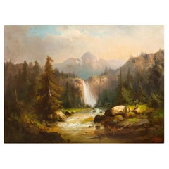
Heine HartwigNative American Camp by a Lake & Waterfall, Limited Edition Signed Hartwig PrintUnknown
Unknown
$1,075
£821.13
€943.57
CA$1,534.57
A$1,682.54
CHF 878.61
MX$20,247.20
NOK 11,073.44
SEK 10,411.88
DKK 7,046.74
About the Item
Limited edition Heine Hartwig print from a painting by the same artist, signed & numbered in gold in the lower right, 722/800. This beautiful, colorful and serene scene depicts a Native American encampment by a lake surrounded by mountains with a waterfall in the distance. It is framed in an attractive gold-colored wood frame with double mats in blue and gold. The print and frame are in excellent condition.
Heinie Hartwig was born in 1937 and grew up in the Santa Clara Valley of California. Hartwig taught himself to paint by studying the "Old Masters." He was attracted to the charm and romance of classic art. He has managed to capture the light, color and style of those great artists. Although most of his work has a western theme, Hartwig is a versatile painter. Many of his paintings are landscapes and still lifes. Heinie Harwig's work has been compared to Albert Bierstadt and John Constable for its romanticism, European feel and composition.
- Creator:Heine Hartwig (1939, American)
- Creation Year:Unknown
- Dimensions:Height: 30.25 in (76.84 cm)Width: 24.5 in (62.23 cm)Depth: 1.75 in (4.45 cm)
- Movement & Style:
- Period:
- Condition:
- Gallery Location:Alamo, CA
- Reference Number:Seller: #15041stDibs: LU117325261772

Heine Hartwig
Heinie Hartwig was born in 1937 and grew up in the Santa Clara Valley of California. Hartwig taught himself to paint by studying the "Old Masters." He was attracted to the charm and romance of classic art. He has managed to capture the light, color and style of those great artists. Although most of his work has a western theme, Hartwig is a versatile painter. Many of his paintings are landscapes and still lives. Heinie Harwig's work has been compared to Albert Bierstadt and John Constable for its romanticism, European feel and composition.
About the Seller
5.0
Platinum Seller
Premium sellers with a 4.7+ rating and 24-hour response times
Established in 2011
1stDibs seller since 2019
293 sales on 1stDibs
Typical response time: 1 hour
- ShippingRetrieving quote...Shipping from: Alamo, CA
- Return Policy
Authenticity Guarantee
In the unlikely event there’s an issue with an item’s authenticity, contact us within 1 year for a full refund. DetailsMoney-Back Guarantee
If your item is not as described, is damaged in transit, or does not arrive, contact us within 7 days for a full refund. Details24-Hour Cancellation
You have a 24-hour grace period in which to reconsider your purchase, with no questions asked.Vetted Professional Sellers
Our world-class sellers must adhere to strict standards for service and quality, maintaining the integrity of our listings.Price-Match Guarantee
If you find that a seller listed the same item for a lower price elsewhere, we’ll match it.Trusted Global Delivery
Our best-in-class carrier network provides specialized shipping options worldwide, including custom delivery.More From This Seller
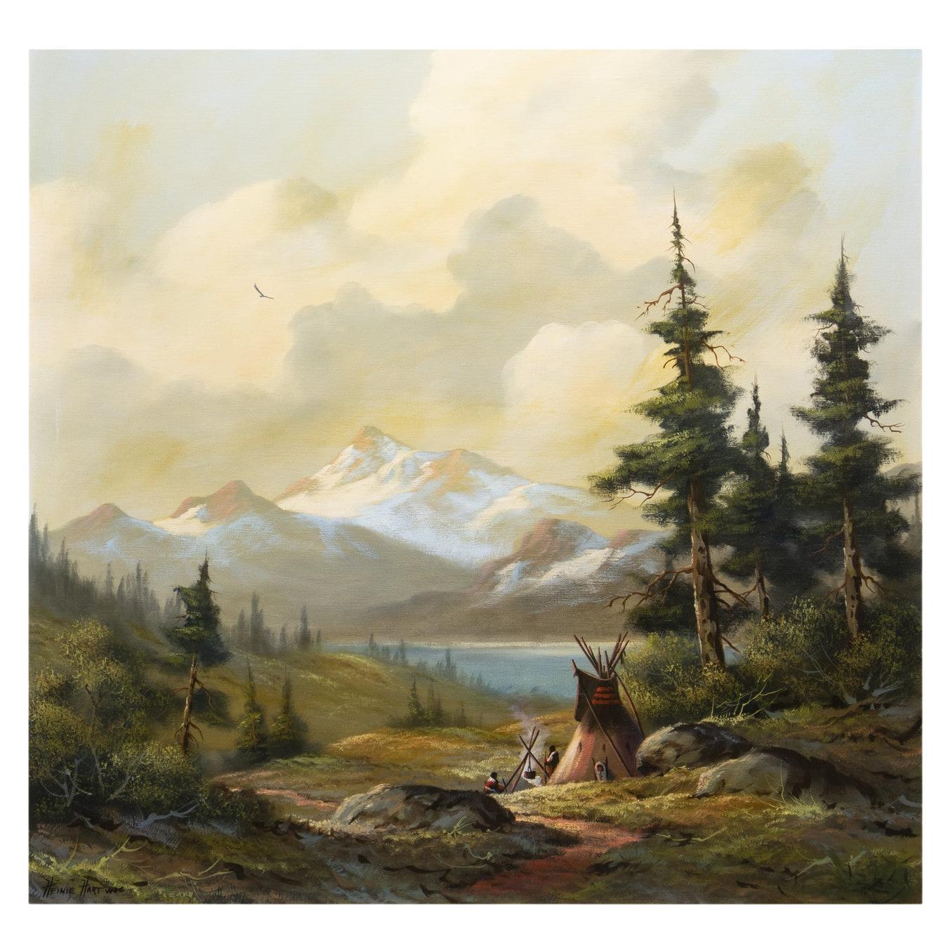
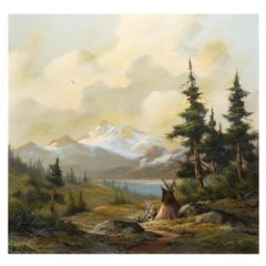
View AllNative American Encampment in a Valley, Limited Edition Hartwig Signed Print
By Heine Hartwig
Located in Alamo, CA
This is a limited edition print from a painting by Heine Hartwig (1937- ) depicting a Native American encampment in a meadow at the base of majestic moun...
Category
Late 20th Century Romantic More Prints
Materials
Other Medium

A Signed Etching of a Pastoral Scene in Picardy, France by Paul Emile Lecomte
By Paul Emile Lecomte
Located in Alamo, CA
A beautiful aquatint etching of a serene pastoral scene in the Picardy region of northern France by Paul Emile Lecomte (1877-1950). A mother and child are seen walking down a path in...
Category
Early 20th Century Impressionist Landscape Prints
Materials
Aquatint

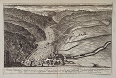
An Antique Engraved View of "Waterfalls in Smoland", Sweden by Erik Dahlberg
By Erik Dahlberg
Located in Alamo, CA
This is an antique engraved view entitled "Delineatio Cataractae" (Waterfalls in Smoland), Sweden in 1705 from "Sueciae Antiquae et Hodiernae"' published in Stockholm by Erik Dahlber...
Category
Early 18th Century Naturalistic Landscape Prints
Materials
Laid Paper, Engraving
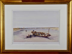
"View Towards the Pyramids": David Roberts' 19th Century Hand Colored Lithograph
By David Roberts
Located in Alamo, CA
"View Towards the Pyramids" is a 19th century full folio sized hand-colored lithograph by David Roberts from his monumental publication "The Holy Land, Syria, Idumea, Arabia, Egypt, and Nubia", published in London in 1846. It depicts a scene of a boat on the Nile, along with several smaller boats. Saccara (Saqqara), near Memphis, the original capital of Egypt, can be seen in the background with its ancient Step Pyramid of Pharoah Djoser. This was the first Egyptian pyramid, designed by the physician and architect Imhotep. Pharoah Snofru’s (Sneferu) failed design Bent Pyramid and the subsequent replacement Red Pyramid can be seen in Dashour (Dashur). These structures preceded the more famous pyramids in Giza.
This lithograph is professionally framed in a gold-colored wood frame, double cream-colored mats and it is glazed with museum quality archival material. The print is in excellent condition.
There are four additional listings of David Roberts engravings of Egypt...
Category
1840s Realist Landscape Prints
Materials
Lithograph
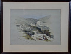
"Christian Church of St. George": A Framed 19th C. Lithograph by David Roberts
By David Roberts
Located in Alamo, CA
This duotone tinted lithograph with additional hand-coloring is entitled "Christian Church of St. George, at Lud Ancient, Lydda". It was drawn by Davi...
Category
Mid-19th Century Naturalistic Landscape Prints
Materials
Lithograph
"Inside of a House in Nootka Sound" (Canada) from Captain Cook's 3rd Voyage
By John Webber
Located in Alamo, CA
"The Inside of a House in Nootka Sound" is an engraving created by William Sharp (1749-1824), from a drawing by John Webber (1752-1793), who was the artist on Captain James Cook's 3rd and final voyage of discovery. It is Plate 65 in "A Voyage to the Pacific Ocean Undertaken by the Command of His Majesty, for Making Discoveries in the Northern Hemisphere", the official British Admirality sanctioned journal published upon completion of the voyage in London in 1784 by Strahan & Cadell.
This engraving is presented in a Koa wood frame and a white mat. There are occasional tiny faint spots, but the print is otherwise in very good condition. Koa wood is legendary in Hawaii. Not only is this amazing wood native to Hawaii, but it is known for the deep rich colors and varied grain pattern. Koa has an honored heritage in Hawaii and is highly revered and sacred. The word “koa” means “warrior” in Hawaiian. The warriors of King Kamehameha the Great, created canoes and weapons from a wood plentiful on the Big Island of Hawaii. This wood became synonymous with the warriors themselves, and it became known as koa.
There are three other engravings listed form the official journal of Captain Cook's 3rd voyage available that are presented in identical Koa wood frames and mats. They would make a wonderful grouping for a display of 2, 3 or 4 prints. Please see listings: LU117324682432, LU117324684022, LU117324684062. A discount is available for a grouping depending on the number of items included.
Nootka Sound is on the west coast of Vancouver Island, British Columbia, Canada. It was explored by Captain Cook in 1778 after he discovered Hawaii during his 3rd voyage. He originally named it King George's Sound, but did record Nootka Sound, which he thought was its native name. Hawaii was originally called The Sandwich Islands in honor of The Earl of...
Category
1780s Realist Interior Prints
Materials
Engraving

You May Also Like
Native American Encampment, western scene
By Harvey Otis Young
Located in New York, NY
This rare and impressive depiction of a white capped mountain and Indian encampment from the 1870's is a great image for a library or rustic room. Exquisitely painted, Young focused...
Category
1870s Hudson River School Landscape Paintings
Materials
Canvas, Oil
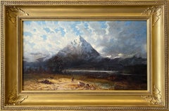
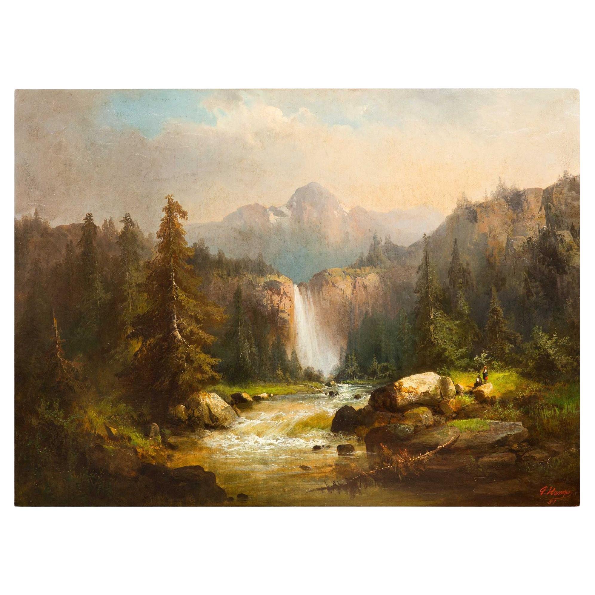
German Landscape Painting of Alpine Mountain Waterfall by Guido Hampe
By Guido Hampe
Located in Shippensburg, PA
GUIDO HAMPE
German, 1839-1902
Alpine Landscape with Waterfall (1881)
Oil on canvas signed lower right "G. Hampe '81"
Item # 106QJY03C
An incredibly powerful Romantic landscape of the Alpine mountains with a waterfall cascading into a valley, the river pouring over the rocks and curving around the bend, flowing past a pair of figures seated on a grassy noll with a transcendant unearthly lighting that creates a focal point of the couple. It is as if the clouds have opened up just to shine light on them, emphasizing the glorious day the man and woman are experiencing on this leisurely hike through nature.
Painted by Guido Hampe in 1881, the painting was acquired by Charles S. Shultz, president of the Hoboken Bank in Montclair, New Jersey where it remained in his home until its deaccession from the home in 2021. The home was particularly interesting for its total originality, the interior looking almost identical throughout its entire life to how it appeared at its inception in 1896. Enclosed in the collection of images is a shot of the painting in situ over the living room fireplace as captured by the Montclair Magazine article on the home in 2020.
The work is signed in his typical script lower right "G. Hampe / 81". It remains housed in the original and substantial giltwood frame, fully restored and a very powerful presentation.
An article on the Charles S. Schultz home can be found by clicking here.
Artist Listings & Bibliography:
* E. Benezit Dictionary of Artists, Vol. VI, Gründ, 2006, p. 1105
Measurements: 32 1/4" H x 42 1/2" W [canvas]; 48 1/2" H x 58 5/8" W x 5 1/4" D [frame]
Condition Report:
A fine presentation ready to place: frame with minor wear/abrasion/loss; canvas with trace grime in the mountain tops and sky and all-over moderate craquelure. Surface bright and vibrant. Retains the original frame that we have had professionally restored with trace regilding and inpainting, some elements recreated; the restoration has preserved the antique nature of the frame and all restoration has been toned to match the aged aesthetic of the frame. Painting was acquired with its apparently first surface, an incredibly thick grime layer that significantly obscured the image - this was likely due to its placement above the fireplace in the Charles Shultz...
Category
Antique 19th Century German Romantic Paintings
Materials
Canvas, Wood, Paint
Sunset at the River Camp by Heinie Hartwig
By Heinie Hartwig
Located in Coeur d'Alene, ID
Exceptionally large, gallery favourite - oil on board. Measures: 36" x 54". Hartwig has won many awards, including the Triton Museum Competition. His paintings have sold at auction -...
Category
Late 20th Century American Paintings
Materials
Paint

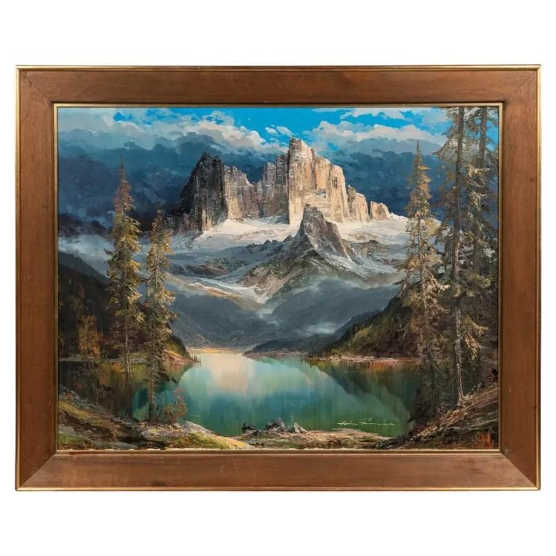
Hans Munnich, Mountain Landscape with Lake Oil on Canvas
Located in Long Island City, NY
Hans Munnich (German, 1892-1970)
Mountain Landscape with Lake
Oil on canvas
signed (lower right)
Measures: 31 x 39 inches.
Frame: 38 1/2 x 46 1/2 inches.
Category
Antique 19th Century Unknown Paintings
Materials
Paint

$5,525 Sale Price
35% Off
Indian Camp Original Oil Painting by Heinie Hartwig
By Heinie Hartwig
Located in Coeur d'Alene, ID
Oil on canvas by Heinie Hartwig (1937-). 36" x 36", framed 43" x 43". Piece portrays a small Native American teepee camp in a clearing. Tall pine trees tower to the left and in the d...
Category
Late 20th Century American Paintings
Materials
Canvas
Mid Century Serene Lake German Impressionist Landscape
By Karl Lechner
Located in Soquel, CA
Mid Century Serene Lake German Impressionist Landscape by Karl Max Lechner
Gorgeous mid-century plein air oil painting of a lake in a sprawling ...
Category
1950s Impressionist Landscape Paintings
Materials
Oil, Cardboard, Canvas
More Ways To Browse
Vintage Camp Signs
French Basque Country
God Save The Queen
Goldfish Bowl
Guggenheim Poster
Israeli Flag
J A Turner
Kawase Hasui Japanese Woodblock Print
Kerr Eby
Klm Poster
Kusama Pumpkin Print
Linocut Flowers
Maria Amalia
Mira Paris
Plaza De Toros
Pop Art Palm Springs
Queen Beatrix
Roy Lichtenstein As I Opened Fire