Items Similar to Map of Biblical Jerusalem

Want more images or videos?
Request additional images or videos from the seller
1 of 8
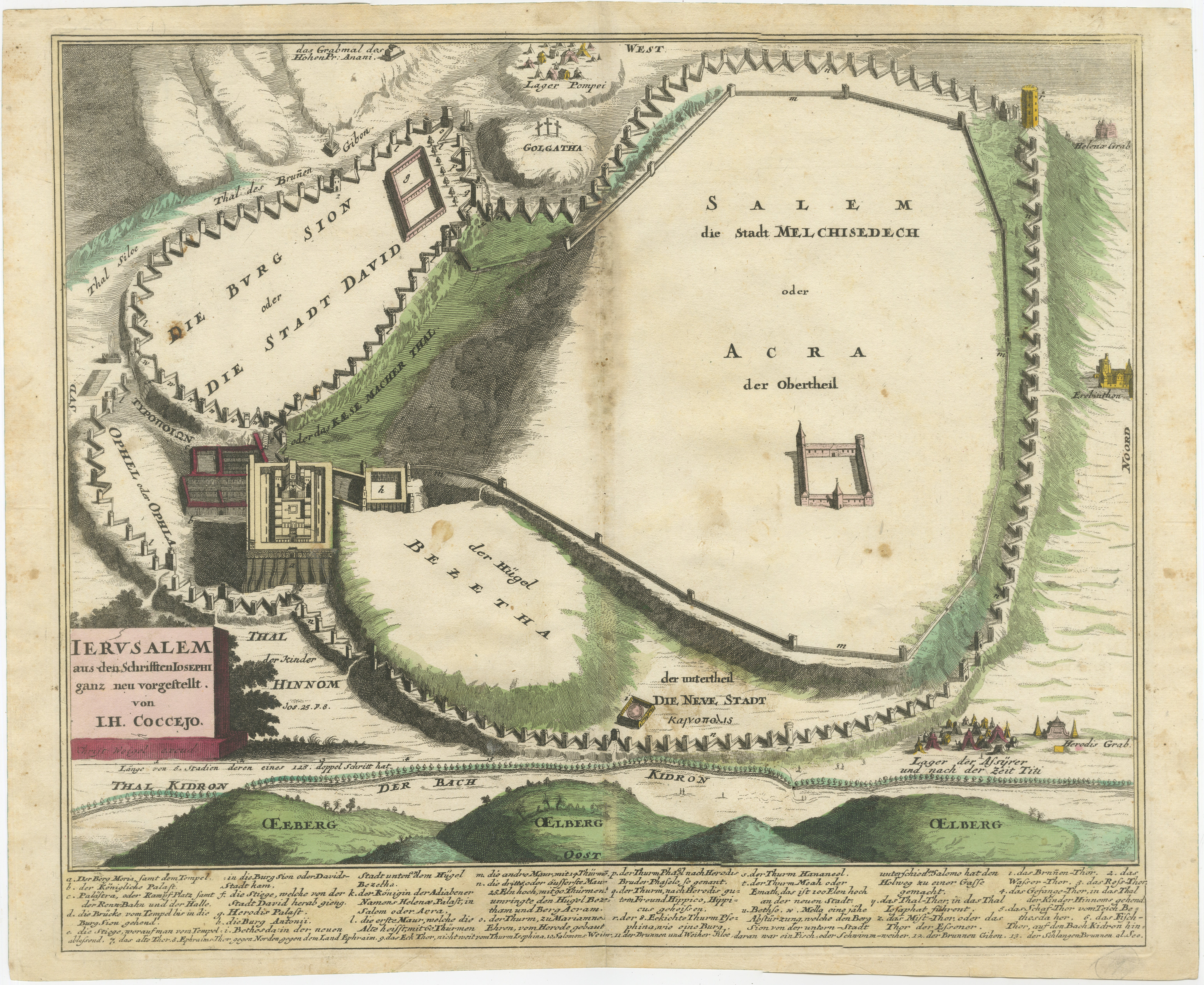
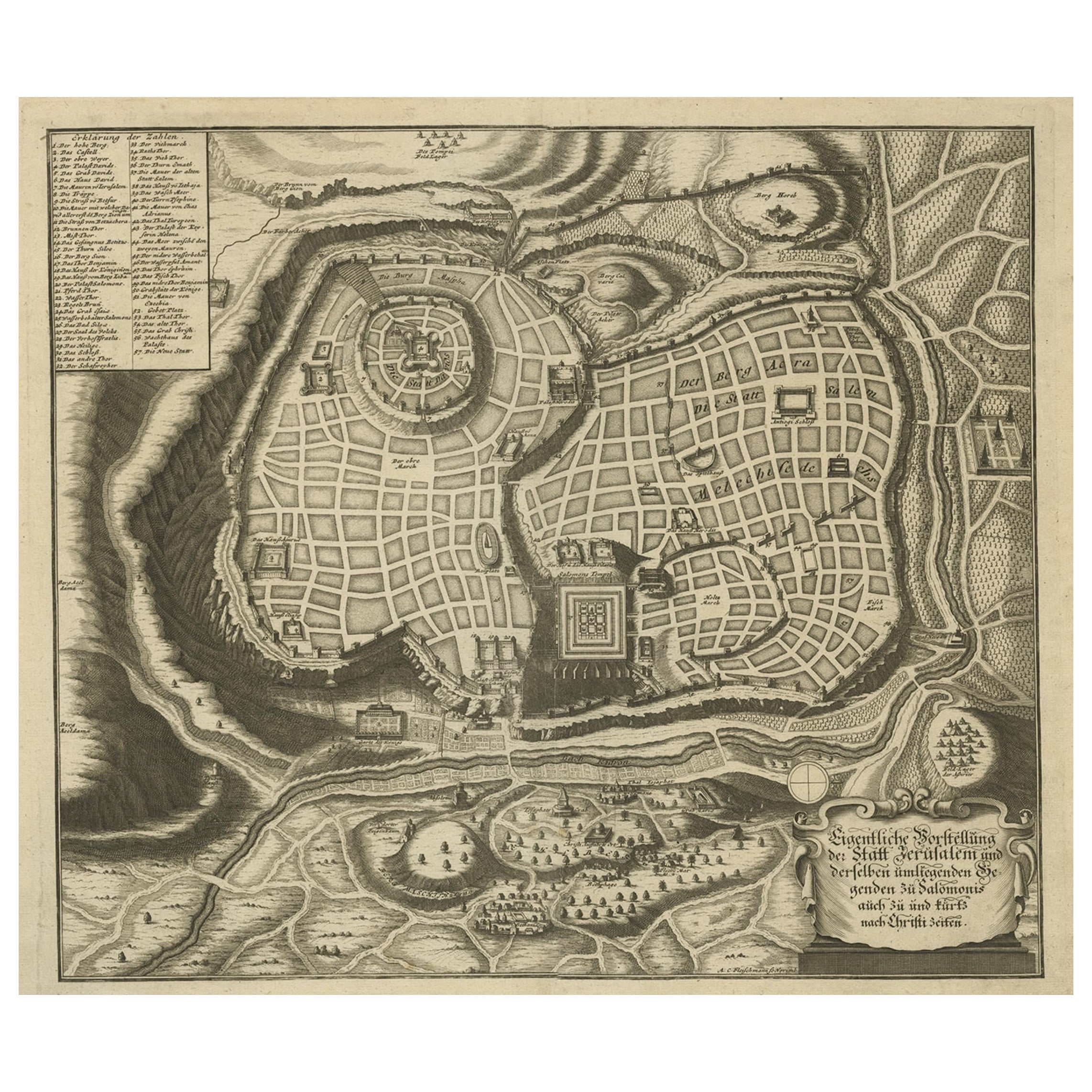
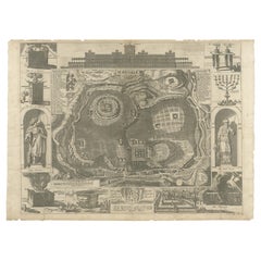
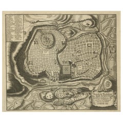
Map of Biblical Jerusalem1720
1720
$600
£453.74
€519.74
CA$840.74
A$917.81
CHF 483.24
MX$10,994.29
NOK 6,180.44
SEK 5,642.84
DKK 3,882.56
About the Item
Original copper engraving hand-colored at the time of publication. Nuremberg, 1720.
- Attributed to:Johannes Heinrich Coccejus (1603 - 1669, German)
- Creation Year:1720
- Dimensions:Height: 14.5 in (36.83 cm)Width: 17.5 in (44.45 cm)
- Medium:
- Period:1720-1729
- Condition:There are a few flecks in the margin and the original center crease is visible.
- Gallery Location:New York, NY
- Reference Number:Seller: 1597441stDibs: LU43837815252

About the Seller
4.9
Recognized Seller
These prestigious sellers are industry leaders and represent the highest echelon for item quality and design.
Gold Seller
Premium sellers maintaining a 4.3+ rating and 24-hour response times
Established in 1972
1stDibs seller since 2016
191 sales on 1stDibs
Typical response time: <1 hour
Associations
International Fine Print Dealers Association
- ShippingRetrieving quote...Shipping from: New York, NY
- Return Policy
More From This Seller
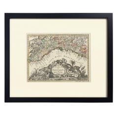
View AllHand-Colored Map of Genoa, circa 1744
By Matthew Seutter
Located in New York, NY
Seutter, Matthew.
Genova [Genoa].
From Atlas minor praecipua Terrarum Imperia...
Augsburg, circa 1744.
Original engraving with old hand-coloring.
Image size: 7 5/8 x 10 inches.
Materials
Paper
Landscape
By Cornelis Ploos van Amstel
Located in New York, NY
Original engraving by old master print-maker Ploos Van Amstel after Jan van Goyen. Holland, 1767. Unframed. Trimmed to size.
Category
1760s Landscape Prints
Materials
Paper
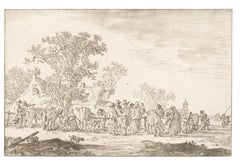
$325
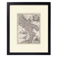
Hand-Colored Map of Southern Italy, circa 1744
By Matthew Seutter
Located in New York, NY
Seutter, Matthew.
Neapolis Regnum...
From Atlas minor praecipua Terrarum Imperia...
Augsburg, circa 1744.
Original engraving with old hand-coloring.
Image size: 10 3/16 x 7 11...
Materials
Paper
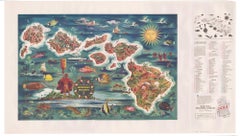
The Dole Map of the Hawaiian Islands.
Located in New York, NY
Original color lithograph. Honolulu. Hawaiian Pineapple Company, 1950.
Category
1950s Prints and Multiples
Materials
Paper
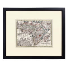
Hand-Colored Map of Africa, circa 1744
By Matthew Seutter
Located in New York, NY
Seutter, Matthew.
Africa.
From Atlas minor praecipua Terrarum Imperia...
Augsburg, circa 1744.
Original engraving with old hand-coloring.
Image size: 7 5/8 x 10 1/8 inches.
Materials
Paper
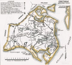
Map of Chatham, Cape Cod
Located in New York, NY
Original map of Chatham, Cape Cod, with recent hand-coloring, 1938. Light toning to edges; has original holes punched in left edge. From "Massachusetts Cit...
Category
1930s Prints and Multiples
Materials
Paper
You May Also Like
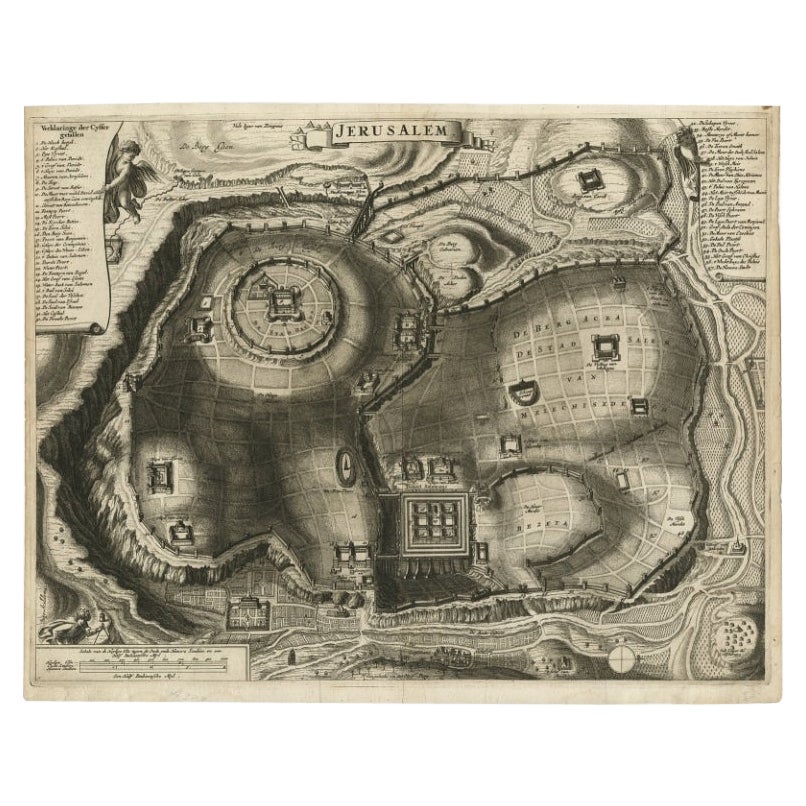
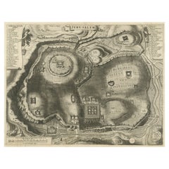
Original Antique Map of Jerusalem Based on Josephus' Writings by Weigel, ca.1720
Located in Langweer, NL
1720 Weigel Map of Jerusalem Based on Josephus' Writings
This intricate 1720 bird's-eye view map of ancient Jerusalem by I.H. Coccejo, engraved by Christoph Weigel, offers a fasc...
Category
Antique 1720s Maps
Materials
Paper

Antique Detailed Map of Jerusalem in Israël with Extensive Key and Scale, 1698
Located in Langweer, NL
Antique map titled 'Jerusalem.'
Plan of the ancient city of Jerusalem. With extensive key and scale. Source unknown, to be determined.
Artists and Engravers: Made by 'Cornelis de...
Category
Antique 17th Century Dutch Maps
Materials
Paper

$624 Sale Price
20% Off
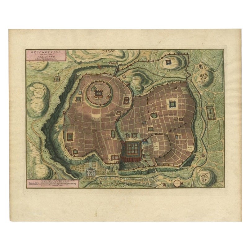
Bird's Eye Plan of the Ancient City of Jerusalem Based on Old Records, c.1725
Located in Langweer, NL
Antique map titled 'Beschryving van het oude Jeruzalem volgens Villalpandus.'
Bird's eye plan of the ancient city of Jerusalem based on Villalpando's foundation map. The plan shows...
Category
Antique Early 18th Century French Maps
Materials
Paper

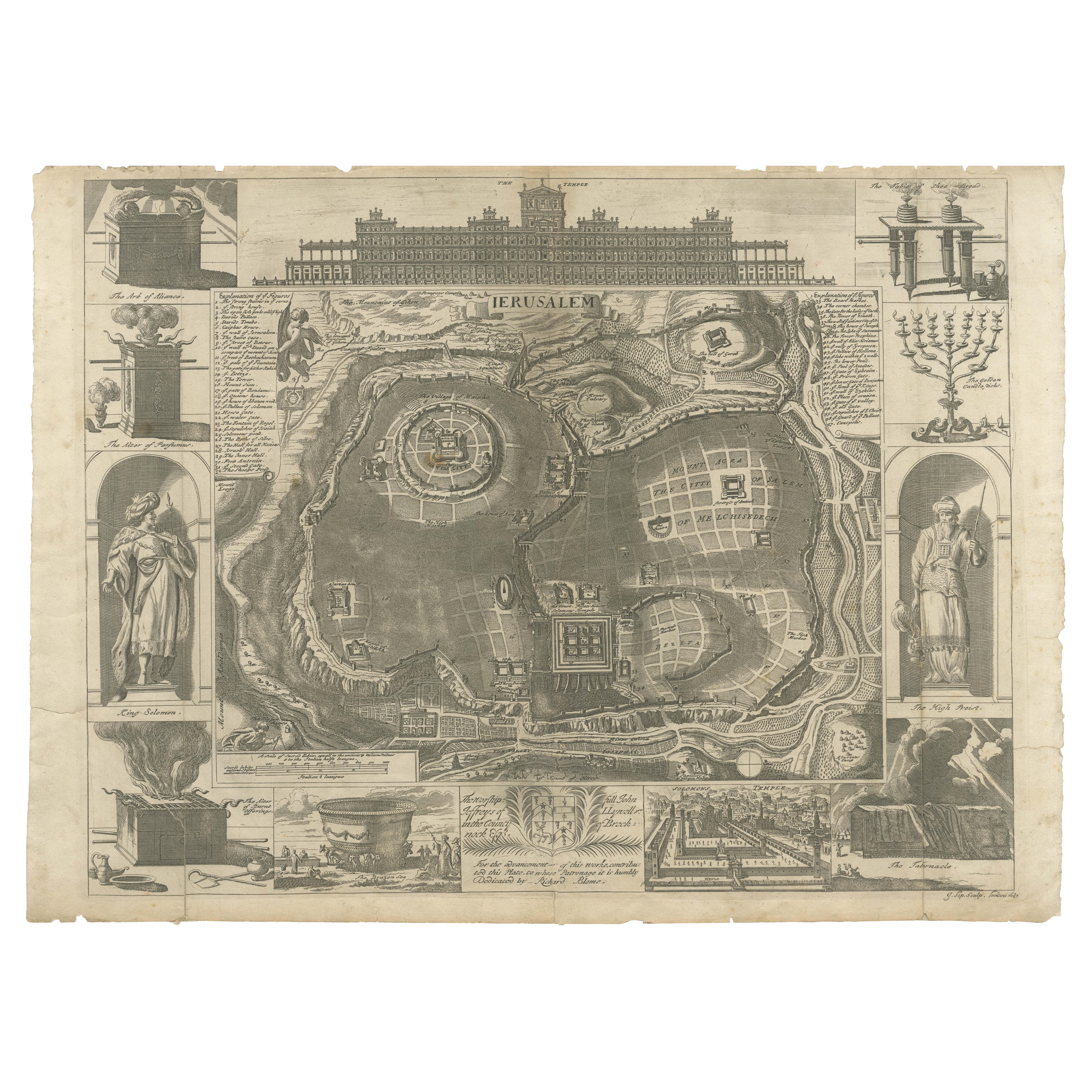
Jerusalem and Temple Imaginary Map by Blome, Published London 1689
Located in Langweer, NL
Imaginary Plan of Jerusalem by Blome after Villalpando, 1689
This impressive antique engraving presents an imaginary plan of Jerusalem by Richard Blome, published in 1689. The engra...
Category
Antique Late 17th Century English Maps
Materials
Paper
Rare Town Plan of Jerusalem, Includes an Extensive Key to Locations etc, 1708
Located in Langweer, NL
Antique map titled 'Eigentliche Vorstellung der Statt Jerusalem und derselben umliegenden Gegenden zu Salomonis auch zu und kurtz nach Christi Zeiten.'
Rare town plan...
Category
Antique Early 1700s Religious Items
Materials
Paper
Plan of Ancient Jerusalem – Cornelis de Bruijn’s Engraved City View c.1698
Located in Langweer, NL
Plan of Ancient Jerusalem – Cornelis de Bruijn’s Engraved City View c.1698
This antique map titled Jerusalem is an intricate plan of the ancient city, richly detailed and marked wit...
Category
Antique Late 17th Century Dutch Prints
Materials
Paper
$518 Sale Price
20% Off
More Ways To Browse
Antique Jerusalem
Hand Colored Copper Engraving
Biblical Maps
Antique Map Of Jerusalem
Tyler Stout
Uncle Sam Poster
Van Dyck Prints
Vintage Gladiolus
Vintage Silkscreen Posters
Vuillard Pastels
Yayoi Kusama Pumpkin Print
Adele Bloch Bauer
Adrian Piper
Andy Warhol Ladies
Andy Warhol Limited Editions
Andy Warhol Signed Lithograph
Bar Mitzvah
Bob Cato