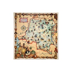
Items Similar to 1949 original map of Belgian Congo - Belgian Ministry of Colonies


Want more images or videos?
Request additional images or videos from the seller
1 of 7
Laboulais1949 original map of Belgian Congo - Belgian Ministry of Colonies1949
1949
$2,266.53
£1,675.68
€1,900
CA$3,117.58
A$3,465.38
CHF 1,816.48
MX$42,320.72
NOK 22,677.70
SEK 21,335.49
DKK 14,464.67
About the Item
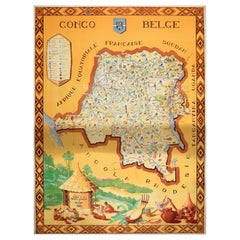
This 1949 original poster titled Congo Belge, created by French illustrator Laboulais, offers a striking example of mid-20th-century colonial-era educational and promotional art. Published by the Belgian Ministry of Colonies (Ministère des Colonies de Belgique), the poster was intended to promote the economic and cultural importance of the Belgian Congo at a time when European powers still held extensive overseas territories.
Created just a decade before Congolese independence, this map-poster reflects the Eurocentric worldview and didactic aims of the period. It was likely used in schools, exhibitions, and administrative offices to showcase the region's agricultural wealth, natural resources, and industrial potential as seen from the colonial perspective.
Laboulais’s work is part of a larger body of educational posters produced in postwar Europe, where such images were used not only for geographic orientation but also to legitimize colonial presence through idealized and sanitized portrayals of overseas territories.
Today, this piece stands as a historical artifact—an opportunity to examine the ways graphic design was employed to shape public perception and influence cultural narratives in the context of colonialism. It is collected for both its historical significance and as a reflection of its time.
Map - Africa - Economy - Colony
Banque de la Société Générale de Belgique
- Creator:Laboulais
- Creation Year:1949
- Dimensions:Height: 46.46 in (118 cm)Width: 34.26 in (87 cm)
- Medium:
- Period:
- Condition:Good condition, traces of folds, on linen.
- Gallery Location:PARIS, FR
- Reference Number:1stDibs: LU1792216384992
About the Seller
5.0
Gold Seller
Premium sellers maintaining a 4.3+ rating and 24-hour response times
Established in 2021
1stDibs seller since 2022
171 sales on 1stDibs
Typical response time: 1 hour
- ShippingRetrieving quote...Shipping from: PARIS, France
- Return Policy
Authenticity Guarantee
In the unlikely event there’s an issue with an item’s authenticity, contact us within 1 year for a full refund. DetailsMoney-Back Guarantee
If your item is not as described, is damaged in transit, or does not arrive, contact us within 7 days for a full refund. Details24-Hour Cancellation
You have a 24-hour grace period in which to reconsider your purchase, with no questions asked.Vetted Professional Sellers
Our world-class sellers must adhere to strict standards for service and quality, maintaining the integrity of our listings.Price-Match Guarantee
If you find that a seller listed the same item for a lower price elsewhere, we’ll match it.Trusted Global Delivery
Our best-in-class carrier network provides specialized shipping options worldwide, including custom delivery.More From This Seller
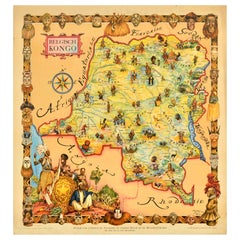
View AllOriginal map of the Belgian Congo illustrated by James Thiriar in 1954
Located in PARIS, FR
Beautiful map of the Belgian Congo illustrated by James Thiriar in 1954. James Thiriar, born in Ixelles in 1889 and died in Brussels in 1965, was a Belgi...
Category
1950s Prints and Multiples
Materials
Paper, Lithograph, Linen
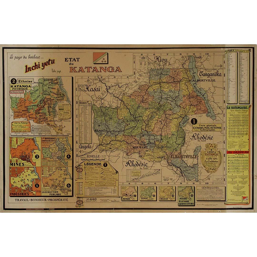
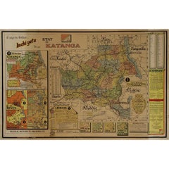
Original 1960 Map by Louis Dressen État du Katanga Congo
Located in PARIS, FR
This original 1960 poster by Louis Dressen, titled État du Katanga, is a rare and powerful visual document from one of the most turbulent moments in post-colonial African history. Pu...
Category
1960s Prints and Multiples
Materials
Paper, Lithograph
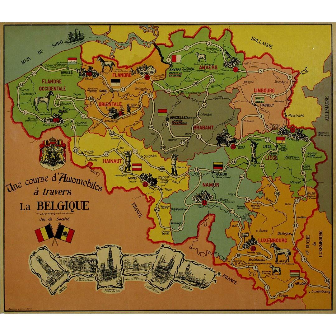
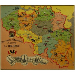
1937 original poster designed as a board game - automobile race across Belgium
Located in PARIS, FR
The 1937 original map poster titled "Une course d'automobiles à travers la Belgique" is a fascinating artifact that combines cartography, graphic design, and the cultural enthusiasm ...
Category
1930s Prints and Multiples
Materials
Lithograph, Linen, Paper
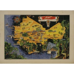
Original map poster by G. Carriat Rolant for AOF (Afrique Occidentale Française)
Located in PARIS, FR
The circa 1950 original map poster by G. Carriat Rolant for AOF (Afrique Occidentale Française) is a notable example of mid-20th-century cartographic art and colonial-era representation. Numbered 584 out of 1000, this limited-edition piece was edited by Paul Bory...
Category
1950s Prints and Multiples
Materials
Lithograph, Paper
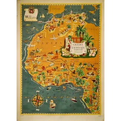
1939 original map Lucien Boucher Crédit Lyonnais Afrique Du Nord Union Française
By Lucien Boucher
Located in PARIS, FR
The 1939 original map by Lucien Boucher, commissioned by Crédit Lyonnais, is a remarkable piece of cartographic art that highlights the regions of North Africa within the French Unio...
Category
1930s Prints and Multiples
Materials
Paper, Lithograph
1947 original map Gouvernement Généraux du Poitou, du Pays d'Aunis
Located in PARIS, FR
The 1947 original map Gouvernement Généraux du Poitou, du Pays d'Aunis et de Saintonge Angoumois, created by Louis Larmat and printed by Dorel in Paris, is a beautifully detailed cartographic representation of a historically significant region in western France. This map, part of Larmat’s extensive body of work, is known for its artistic craftsmanship and geographical precision, offering a comprehensive view of the historical administrative regions of Poitou, Aunis, Saintonge, and Angoumois, which played key roles in the political and cultural history of France.
Louis Larmat is celebrated for his contributions to cartography, particularly for his ability to merge historical context, topographical detail, and aesthetic elegance in his maps. His works, especially those focusing on the vinicultural regions of France, are highly respected for their accuracy and artistry. This particular map, although focusing on a more political and historical aspect rather than the wine regions he is most famous for, continues his tradition of detailed regional documentation. Larmat’s cartographic works often transcended the realm of simple geographical depiction, becoming historical documents that encapsulate the cultural essence of the regions they portray.
This map illustrates the general governments (administrative divisions) of the provinces of Poitou, Aunis, Saintonge, and Angoumois, regions that are steeped in history. These areas, situated along France’s western coastline, have been integral to the country’s political, economic, and cultural development over centuries. The region of Poitou, for example, is historically known as the birthplace of Eleanor of Aquitaine...
Category
1940s Prints and Multiples
Materials
Lithograph, Paper

You May Also Like
Original Vintage Africa Travel Poster Belgian Congo Congo Belge Illustrated Map
Located in London, GB
Original vintage Africa travel poster for the Belgian Congo / Congo Belge including a pictorial map of French Equatorial Africa, Sudan, Uganda, Tanganyika, Rhodesia and Angola. Desig...
Category
Vintage 1940s Belgian Posters
Materials
Paper
Original Vintage Travel Map Poster Belgian Congo Africa Thiriar Margraff Belgium
Located in London, GB
Original vintage travel map poster for the Belgian Congo / Belgisch Kongo featuring a pictorial map of the area bordering Equatorial Africa, French Sudan, ...
Category
Vintage 1940s Belgian Posters
Materials
Paper
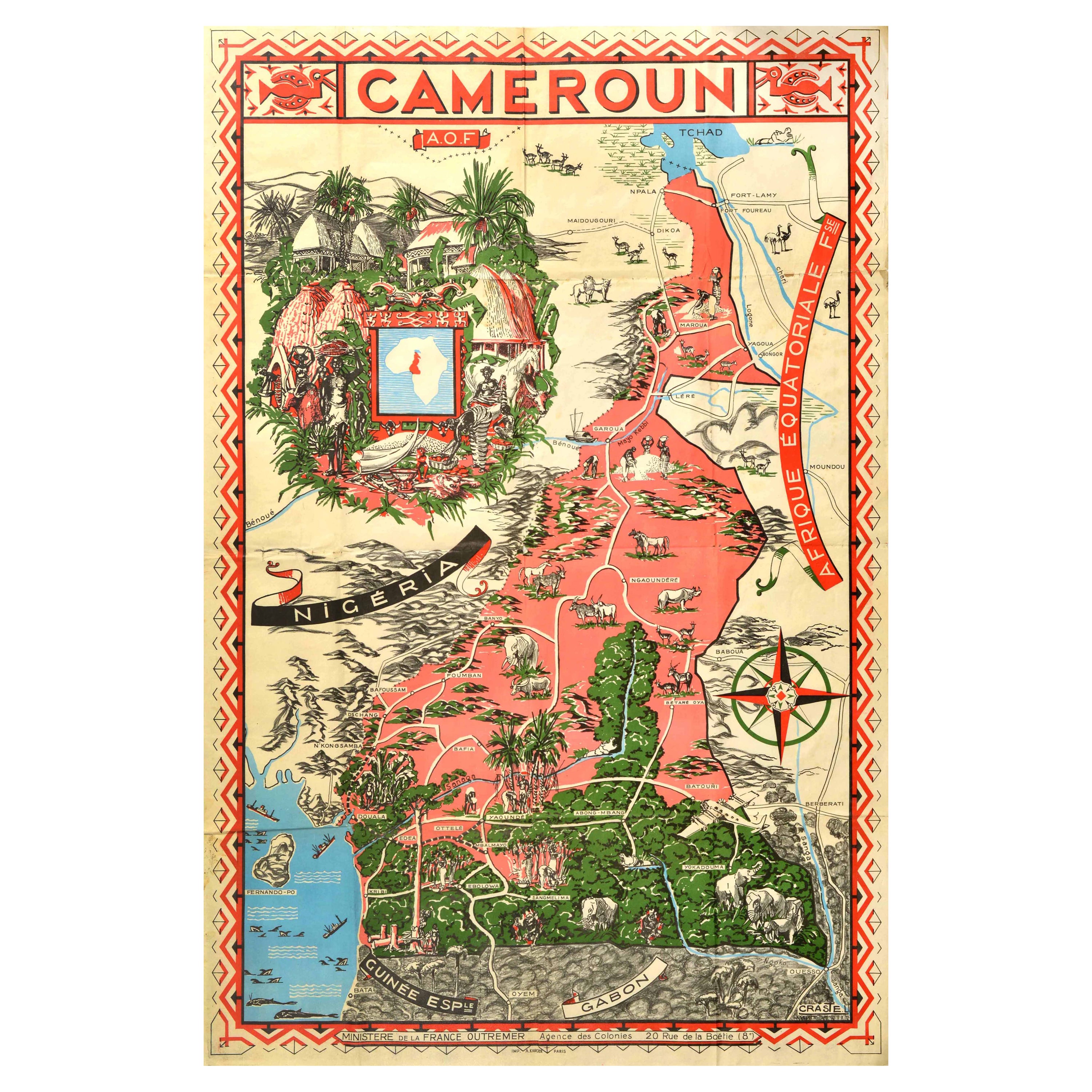
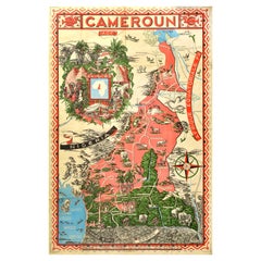
Original Vintage Illustrated Map Poster Afrique Equatoriale Francaise Cameroon
Located in London, GB
Original vintage illustrated map poster for Cameroun AOF Afrique Occidentale Francaise / Cameroon French West Africa showing the Central African country of ...
Category
Vintage 1950s French Posters
Materials
Paper
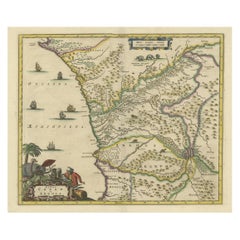
Antique Map of West Africa, focused on the Congo and Angola
Located in Langweer, NL
Original antique map titled 'Regna Congo et Angola'. Decorative 17th Century English map of a portion of West Africa, focused on the Congo and Angola. The map is centered on the Zair...
Category
Antique Late 17th Century Maps
Materials
Paper
$811 Sale Price
20% Off
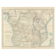
Antique Map of Central Africa, 1903, With Colonial Territories Explorers Routes
Located in Langweer, NL
Antique Map of Central Africa, 1903, Featuring Colonial Territories and Explorers’ Routes
This antique map, titled "Central Africa," was engraved and published in 1903 by W. & A.K. ...
Category
Early 20th Century Maps
Materials
Paper
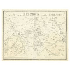
Antique Map of the Region near Cologne, Germany
Located in Langweer, NL
Antique map titled 'Carte de la Belgique d'après Ferraris'. Original antique map of the region near Cologne, Germany. Cologne is the largest city of the German western state of North...
Category
Antique Mid-19th Century Maps
Materials
Paper
$419 Sale Price
20% Off
More Ways To Browse
Map Stand
Large Vintage Map
Congo African Art
Vintage African Map
Colonial Africa Poster
Beer Posters
Tiffany Indian
Vintage Raf Posters
Vintage Us Army Posters
White Bird Cage
Aircraft Identification
Andy Warhol Cars
Cuba Poster
Maillol Aristide
Red Robin Vintage
Vintage Middle East Poster
Vintage St Louis Posters
Woman With Two Dogs