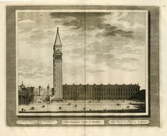
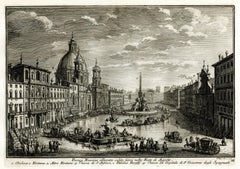
Altra Veduta della Piazza di S. Marco
View Similar Items


Want more images or videos?
Request additional images or videos from the seller
1 of 10
Albert MeyeringhAltra Veduta della Piazza di S. Marco1723
1723
Price:$300
$450List Price
About the Item
- Creator:Albert Meyeringh (1645 - 1714, Dutch)
- Creation Year:1723
- Dimensions:Height: 15.13 in (38.44 cm)Width: 19.13 in (48.6 cm)
- Medium:
- Movement & Style:
- Period:
- Condition:
- Gallery Location:Fairlawn, OH
- Reference Number:Seller: FA80891stDibs: LU14013621042
About the Seller
5.0
Recognized Seller
These prestigious sellers are industry leaders and represent the highest echelon for item quality and design.
Gold Seller
Premium sellers maintaining a 4.3+ rating and 24-hour response times
Established in 1978
1stDibs seller since 2013
796 sales on 1stDibs
Typical response time: 1 hour
Associations
International Fine Print Dealers Association
Authenticity Guarantee
In the unlikely event there’s an issue with an item’s authenticity, contact us within 1 year for a full refund. DetailsMoney-Back Guarantee
If your item is not as described, is damaged in transit, or does not arrive, contact us within 7 days for a full refund. Details24-Hour Cancellation
You have a 24-hour grace period in which to reconsider your purchase, with no questions asked.Vetted Professional Sellers
Our world-class sellers must adhere to strict standards for service and quality, maintaining the integrity of our listings.Price-Match Guarantee
If you find that a seller listed the same item for a lower price elsewhere, we’ll match it.Trusted Global Delivery
Our best-in-class carrier network provides specialized shipping options worldwide, including custom delivery.More From This Seller
View AllOstiakes
By Cornelis de Bruijn
Located in Fairlawn, OH
Ostiakes
Engraving, 1718
From: Voyages de Corneille le Brun par la Moscovie, en Perse, et aux Indes Occidentales (French translation, 1718), Chapter XXI
The Ostyak are a member of an...
Category
1710s Old Masters Landscape Prints
Materials
Engraving

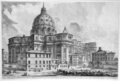
Veduta dell'esterno della gran Basilica di S. Pietro in Vaticano
By Giovanni Battista Piranesi
Located in Fairlawn, OH
Veduta dell'esterno della gran Basilica di S. Pietro in Vaticano (View of the Exterior of St. Peter's Basilica in the Vatican)
Etching, 1748
From the first printing of the "Vedute di Roma"
An early impression with strong contrasts
Before the price and the addition of numbers in the later states.
A view of Michelangelo's done from behind the Piazza, redesigned in 1547
Condition: Excellent
Plate size: 15 3/4 x 24 3/4 inches
Reference: Robison 5 a/g
Hind 5 i/VII
Focillon 54.789
Designed principally by Donato Bramante, Michelangelo, Carlo Maderno and Gian Lorenzo Bernini, St. Peter's is the most renowned work of Renaissance architecture and the largest church in the world. While it is neither the mother church of the Catholic Church nor the cathedral of the Diocese of Rome (these equivalent titles being held by the Archbasilica of Saint John Lateran in Rome), St. Peter's is regarded as one of the holiest Catholic shrines...
Category
1740s Old Masters Landscape Prints
Materials
Etching
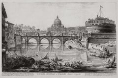
The Ponte and Castel S. Angelo (Veduta del Ponte e Castello Sant' Angelo)
By Giovanni Battista Piranesi
Located in Fairlawn, OH
The Ponte and Castel S. Angelo
Veduta del Ponte e Castello Sant' Angelo
Etching, 1754
Signed in the plate lower right above the caption
From: Vedute di Roma
A proper Roman printing w...
Category
1750s Old Masters Landscape Prints
Materials
Etching
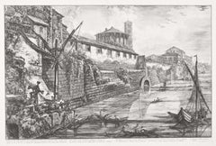
View of the Ancient Structure built by Tarquinius Superbus called the Bel Lido
By Giovanni Battista Piranesi
Located in Fairlawn, OH
View of the Ancient Structure built by Tarquinius Superbus called the Bel Lido, and like others built by Marcus Agrippa in the time of Augustus when he cleaned all the sewers leading...
Category
1750s Old Masters Landscape Prints
Materials
Etching
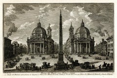
Piazza del Popolo con Obelisco Egizio
By Giuseppe Vasi
Located in Fairlawn, OH
Piazza del Popolo con Obelisco Egizio
Etching, 1752
Signed in the plate lower left (see photo)
From: Della Magnificenze di Roma Antica e Moderna ( The Magnificense of Ancient and Mod...
Category
1750s Old Masters Landscape Prints
Materials
Etching
Piazza Navona allagata solito farsi nelle Feste di Agosto
By Giuseppe Vasi
Located in Fairlawn, OH
Piazza Navona allagata solito farsi nelle Feste di Agosto
Etching, 1752
Signed in the plate lower right (see photo)
From: Della Magnificenze di Roma Antica e Moderna ( The Magnificen...
Category
1750s Old Masters Landscape Prints
Materials
Etching
You May Also Like
The Landscape - Engraving after Rembrandt - 19th Century
By Charles Amand Durand
Located in Roma, IT
The landscape is an engraving on ivory-colored paper realized by Charles Amand Durand after an etching by Rembrandt. This wonderful piece of art belongs t...
Category
19th Century Old Masters Figurative Prints
Materials
Engraving
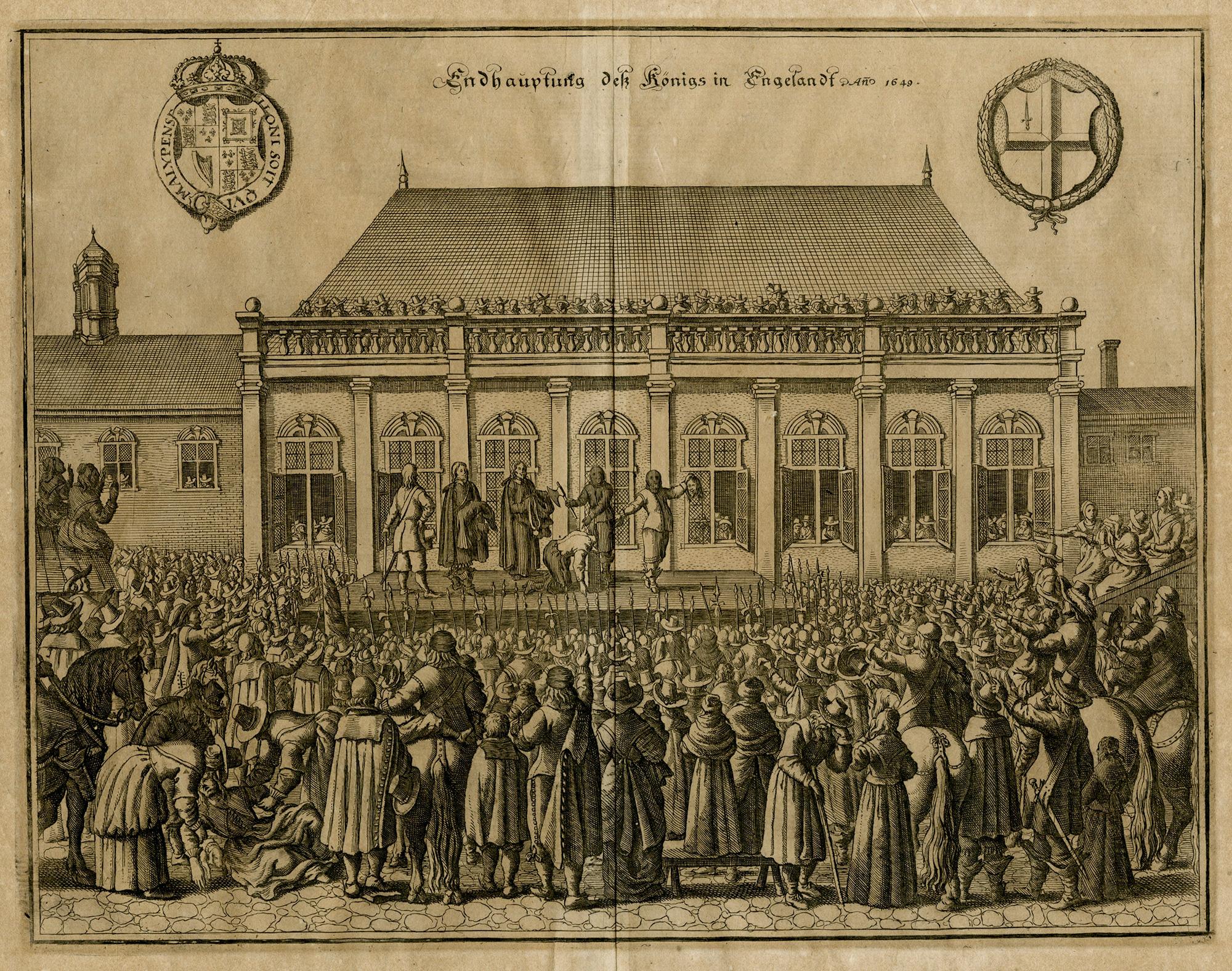
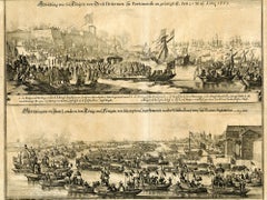
The Beheading of the King of England; Enthauptung des Königs in England
By Matthäus Merian the Elder
Located in Middletown, NY
The execution of Charles I (1600-1649) at Whitehall, January 30th 1649, in front of the Banqueting House. The executioner holding the head of Charles up to the crowd below.
Engravin...
Category
Mid-17th Century Old Masters Landscape Prints
Materials
Engraving, Laid Paper

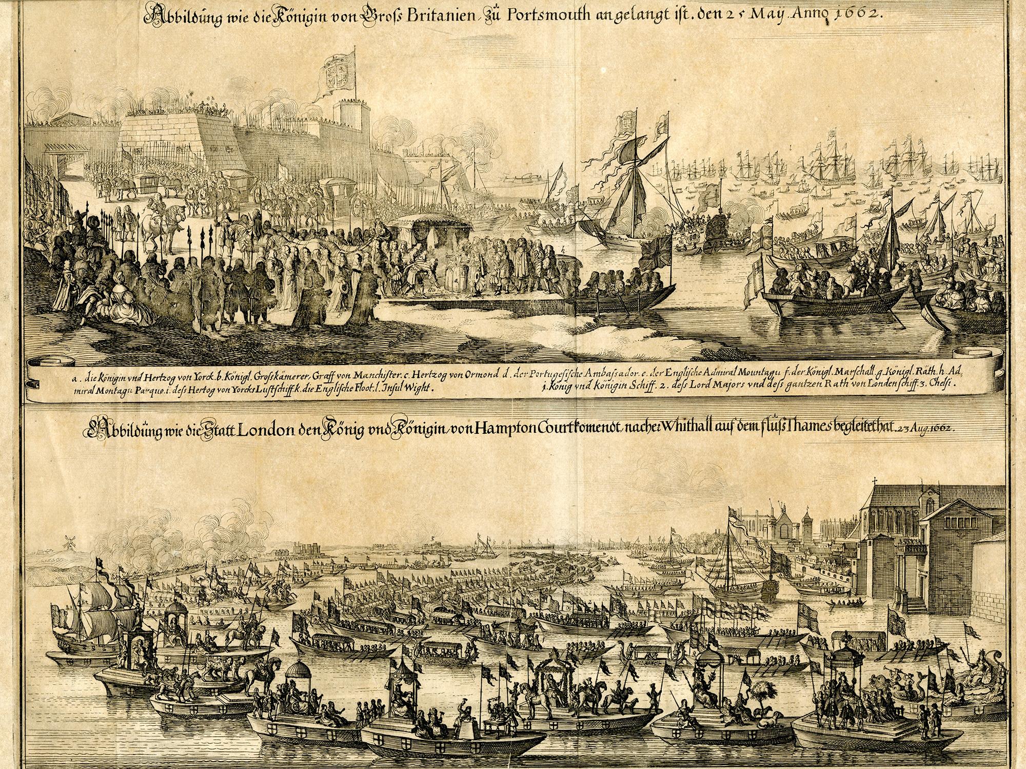
The Queen of Great Britain arriving in Portsmouth 25 May 1662 & The Arrival in L
By Matthäus Merian the Elder
Located in Middletown, NY
Two images of Queen Catharina of Braganza; one before her marriage to King Charles II, the other after, as Queen of Great Britian. Engraved by Matthiäus Merian, father of Maria Sybli...
Category
Mid-17th Century Old Masters Landscape Prints
Materials
Laid Paper, Engraving
Landscape - Engraving after Rembrandt - 19th Century
By Charles Amand Durand
Located in Roma, IT
Landscape is an engraving on ivory-colored paper realized by Charles Amand Durand (1831-1905) after an etching by Rembrandt. This wonderful piece of art belongs to a late edition of ...
Category
19th Century Old Masters Figurative Prints
Materials
Engraving
$225 Sale Price
25% Off
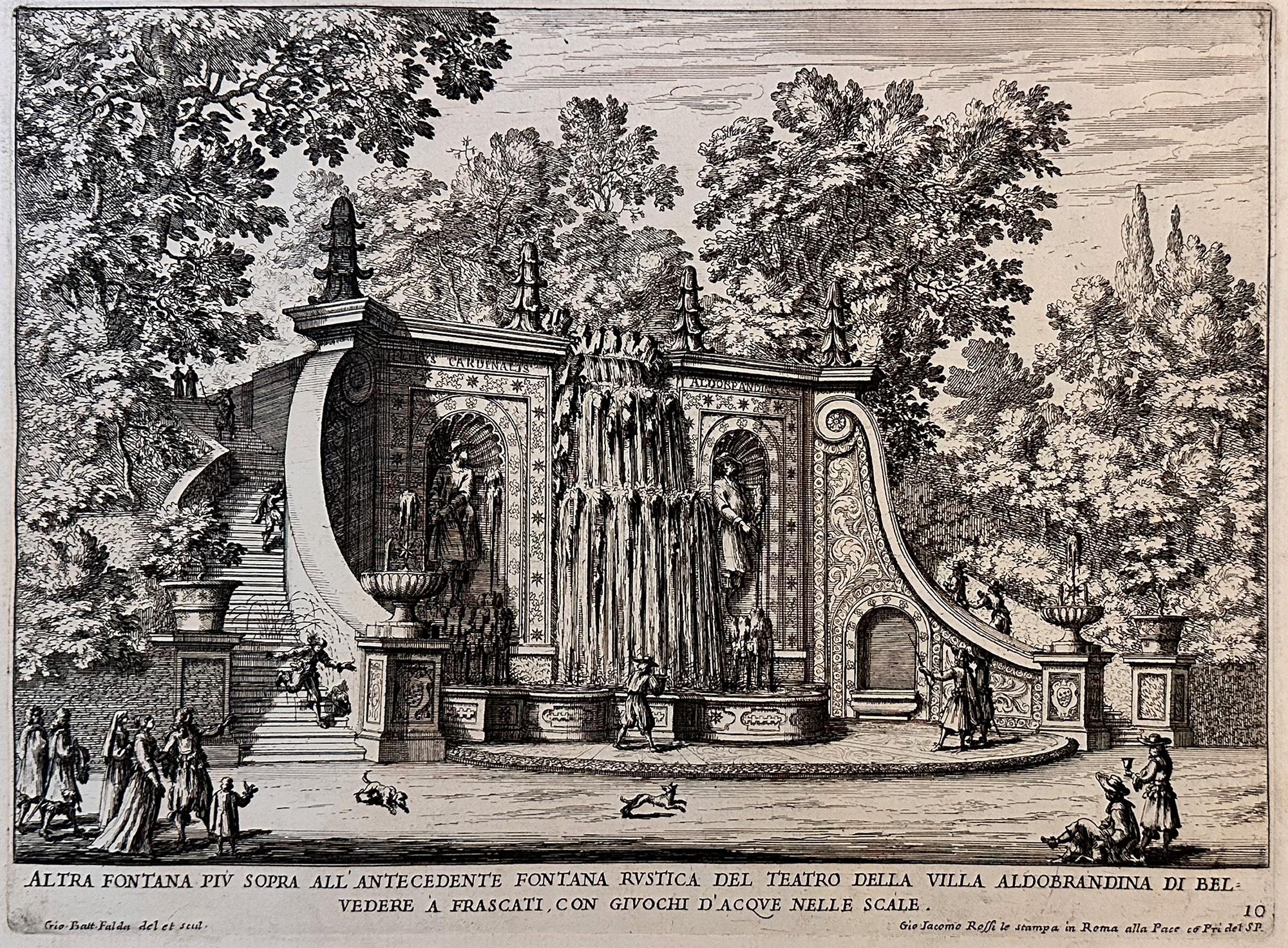
Fountains of Rome
By Giovan Battista Falda
Located in Middletown, NY
A charming scene with romping dogs and spectators watching the cascading water play a trick on an unsuspecting man who is sprayed as he descends the steps, ...
Category
Early 17th Century Old Masters Landscape Prints
Materials
Laid Paper, Engraving, Etching
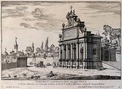
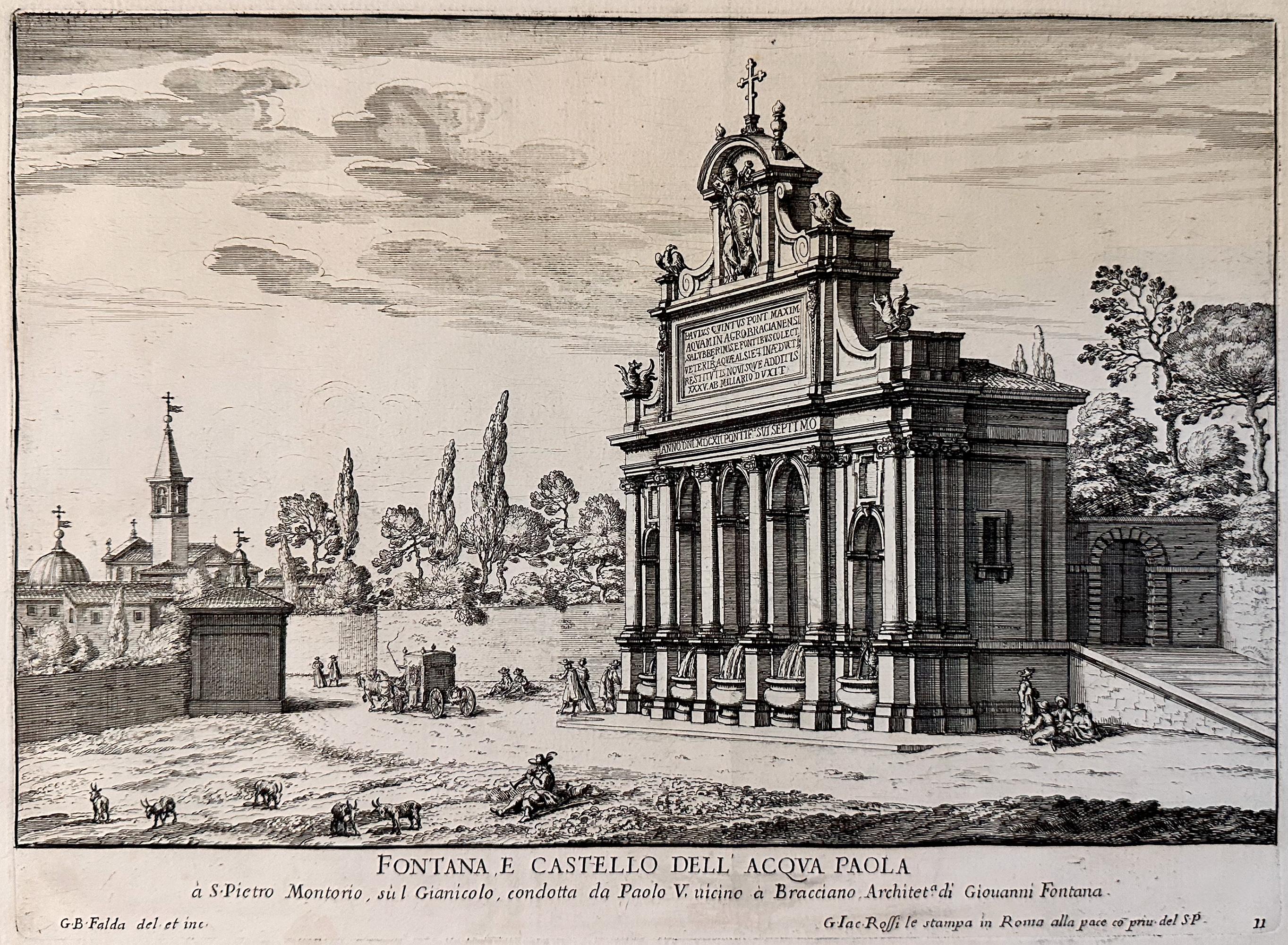
Fountains of Rome; Fontana e castello dell'Acqua
By Giovan Battista Falda
Located in Middletown, NY
Rome: Giovanni Giacomo De Rossi, 1625.
Etching and engraving on cream laid paper, 8 3/8 x 11 1/4 inches (222 x 286 mm), full margins. In good condition with some light yellow discol...
Category
Early 17th Century Old Masters Landscape Prints
Materials
Laid Paper, Engraving, Etching