Items Similar to 18th Century Engraving "Attack with a Battering Ram" by Montfaucon
Want more images or videos?
Request additional images or videos from the seller
1 of 13
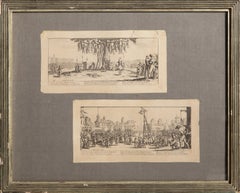
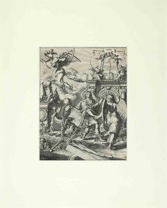
Bernard de Montfaucon18th Century Engraving "Attack with a Battering Ram" by Montfaucon1719
1719
$875
£662.24
€760.06
CA$1,246.51
A$1,351.87
CHF 710.05
MX$16,420.75
NOK 8,885.19
SEK 8,365.91
DKK 5,676.79
About the Item
This early original copper-plate engraving entitled "Attaque avec le Belier" from 'L'antiquité expliquée et représentée en figures' (Antiquity Explained and Represented in Diagrams), published in Paris in 1719 by Bernard de Montfaucon. It depicts an ancient Roman bas relief scene illustrating a Roman method of attacking a foe with a battering ram.
This early 18th century engraving is presented in an attractive ornate black wood frame with a cream-colored double mat with a thin black inner mat. It is glazed with plexiglass. The print, frame, mat and glazing are in excellent condition.
Dom Bernard de Montfaucon (1655-1741) was a French Benedictine monk of the Congregation of Saint Maur. He was an academic scholar who founded the discipline of palaeography (the study of old handwriting and texts so that ancient manuscripts can be deciphered, read and studied). He is also regarded as one of the founders of modern archaeology. In 1719, Montfaucon was named by Philippe II, Duke of Orléans and younger brother of King Louis XIV to the Académie des Inscriptions et Belles-Lettres. Also in 1719, after the death of the Jesuit priest, Michel Le Tellier (1643-1719), confessor to the late King Louis XIV, Montfaucon then became confessor to the young King Louis XV.
- Creator:Bernard de Montfaucon (1655 - 1714)
- Creation Year:1719
- Dimensions:Height: 21.88 in (55.58 cm)Width: 25.5 in (64.77 cm)Depth: 0.88 in (2.24 cm)
- Medium:
- Movement & Style:
- Period:
- Condition:
- Gallery Location:Alamo, CA
- Reference Number:Seller: # 22101stDibs: LU117326085702
About the Seller
5.0
Platinum Seller
Premium sellers with a 4.7+ rating and 24-hour response times
Established in 2011
1stDibs seller since 2019
293 sales on 1stDibs
Typical response time: 1 hour
- ShippingRetrieving quote...Shipping from: Alamo, CA
- Return Policy
Authenticity Guarantee
In the unlikely event there’s an issue with an item’s authenticity, contact us within 1 year for a full refund. DetailsMoney-Back Guarantee
If your item is not as described, is damaged in transit, or does not arrive, contact us within 7 days for a full refund. Details24-Hour Cancellation
You have a 24-hour grace period in which to reconsider your purchase, with no questions asked.Vetted Professional Sellers
Our world-class sellers must adhere to strict standards for service and quality, maintaining the integrity of our listings.Price-Match Guarantee
If you find that a seller listed the same item for a lower price elsewhere, we’ll match it.Trusted Global Delivery
Our best-in-class carrier network provides specialized shipping options worldwide, including custom delivery.More From This Seller
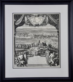
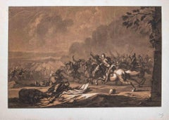
View AllDaniel Marot's The Siege of the Dutch Fortified City of Ypres by Louis XIV
By Daniel Marot
Located in Alamo, CA
"Ypres, Grand Ville Riche & Marchande" is an engraving and etching by Daniel Marot (le Vieux) (1661–1752). It depicts a view of the siege of the city of Ypres and its citadel on the left in the Spanish Netherlands by Louis XIV's troops. This battle took place between March 18 and March 25, 1678, as part of the Franco-Dutch War. Marot illustrated in great detail (best appreciated with magnification) the French attack on the strong pentagonal citadel on the extreme left, which had been built recently in anticipation of a French attack. The trenches built by the French approaching the town are seen on the right. King Louis XIV can be seen in the foreground surveying the battle mounted on his white horse, surrounded by his officers and troops.
The print is presented in an attractive ornate black wood frame with a cream-colored double mat with a black inner trim. It is glazed with plexiglas. The frame measures 25.38" x 22.63" x .88". The engraving, frame, mat and glazing are in excellent condition.
Artist: Daniel Marot (1661–1752) was also called "Le Vieux". He was the son of the famous architect, Jean Marot. Marot had diverse interests and talents. In addition to his art, he designed garden projects, architectural ornaments, furniture, and even upholstery. Marot as a Huguenot protestant was forced to leave France in 1685 following the revocation of the Edict of Nantes. He emigrated to Holland, where he worked for William of Orange (an arch enemy of his former employer Louis XIV). Marot was largely responsible for the interiors of Williams palace at the Loo. In 1694 he went Britain as William had married Queen Mary and he had become King William III of England. He later returned to Holland in about 1698 and died in the Hague in 1752. He left a lasting legacy on the decorative arts in the Netherlands, where his grand version of the Louis XIV style remained popular into the 1730s.
Historical Background: In October 1677, Mary Stuart, niece and possible successor of Charles II of England, married Louis XIV's arch enemy William III of Orange...
Category
Late 17th Century Old Masters Landscape Prints
Materials
Engraving, Etching
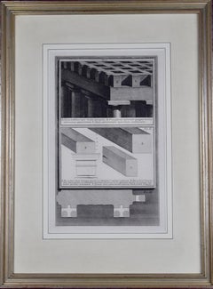
18th Century Etching of Ancient Roman Architectural Objects by Giovanni Piranesi
By Giovanni Battista Piranesi
Located in Alamo, CA
A. Tigna Protensa Super Media Epistylia, B. Praecisiones Tigorum Quaqua Versus Extrinsectus Apparentium, C. Opae Extremitates Tigorum Contintes, Fig. I, plate 88 from "Vasi, Candelab...
Category
Mid-18th Century Old Masters Figurative Prints
Materials
Etching
Ancient Roman Architecture: Original Framed 18th C. Etching by G. Piranesi
By Giovanni Battista Piranesi
Located in Alamo, CA
"Veduta del Sepolcro della Famiglia Plauzia per la Strada Che Conduce da Roma a Tivoli vicino a Ponte Lugano" from "Le Antichità Romane" (Roman Antiquities), one of the most famous works by Piranesi. "Antichita" illustrates the tombs along the Appian Way...
Category
Early 18th Century Old Masters Figurative Prints
Materials
Etching, Engraving, Drypoint
Ancient Roman Architectural Frieze: An 18th C. Piranesi Etching
By Giovanni Battista Piranesi
Located in Alamo, CA
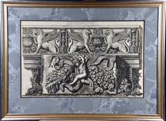
This framed original 18th century etching is entitled "Fregio antico di marmo con Ippogrifi, nel cortile del palazzo della Valle" (Ancient Marble Frieze with Hippogriffs in the Courtyard of The Palace of the Valley). The etching is by Giovanni Battista Piranesi, published in Rome in 1778. It is from Piranesi's monumental work "Vasi, Candelabri, Cippi, Sarcofagi, Tripodi, Lucerne, Ed Ornamenti Antichi", (Vases, candelabra, grave stones...
Category
Early 18th Century Old Masters Figurative Prints
Materials
Etching
William Hogarth's "Analysis of Beauty": A Set of Two Framed 18th C. Engravings
By William Hogarth
Located in Alamo, CA
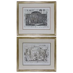
The two plates in this set were created utilizing both engraving and etching techniques by William Hogarth in 1753, originally as illustrations of his book on aesthetics, entitled "Analysis of Beauty". Due to their popularity, these plates were later published separately. The publication line in the lower right reads: "Designed, Engraved, and Publish'd by Wm. Hogarth, March 5th 1753, according to Act of Parliament." Hogarth's original copper plates were refurbished where needed by James Heath and engravings were republished in London in 1822 by Braddock, Cradock & Joy. This was the last time Hogarth's copper plates were used for printing. Most were melted during World War I for the construction of bombs.
These large folio sized "Analysis of Beauty" engravings are presented in antiqued gold-colored frames with double mats; the outer silk mats are light brown-colored and the inner mats are dark brown. Each frame measures 27.38" x 31.25" x 1.13". There is one tiny spot in the right margin of plate 1 and another in the lower margin; the latter could be from the printing process. The prints are otherwise in excellent condition.
The "Analysis of Beauty" series is in the collection of many major museums, including: The British Museum, The Metropolitan Museum of Art, The Tate Museum, The Chicago Art Institute and The Fine Arts Museums of San Francisco.
The first engraving (Plate 1) depicts a courtyard of statues which is filled with some of the most famous works of classical sculpture. The most important sculptures are surrounded by less impressive works. The Medicean Venus (#13) is in the center with a statue of Julius Caesar (#19) to the right, elevated on a pulley with a short, overdressed Brutus stands over the falling Caesar. The Apollo Belvedere (#12) is next. A judge stands to the right with his foot on a cherub (#16). Another crying cherub holds a gallows and wipes his tears with the judge's robe.
A sphinx (#21) and the drunken Silenus (#107) are below the Venus. Michaelangelo's torso (#54) and a statue of Antonius (#6) are seen in the foreground. The Farnese Hercules (#3) and a bust of another Hercules (#4) under two statuettes of Isis are also included in the scene.
The key to these objects is included in the form of a serpentine line winding around a cone (#26), Hogarth's "Line of Beauty". For Hogarth the winding line is an essential element of beauty in art. Hogarth's theory of beauty is communicated in this plate.
Plate 2 is thought to represent the Wanstead Assembly, with the Earl of Tynley and his household. It is an adaptation of a scene in the Happy Marriage series, which complements Hogarth's Marriage à la Mode...
Category
Mid-18th Century Old Masters Interior Prints
Materials
Engraving, Etching
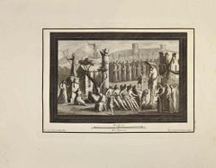
Piranesi 18th C. Etching "Reliquiae Theartri Pompejani" an Ancient Roman Theater
By Giovanni Battista Piranesi
Located in Alamo, CA
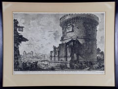
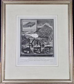
This a framed Giovanni Battista Piranesi (1720-1778) etching entitled "Reliquiae Theartri Pompejani" (Remains of the Theatre of Pompey) from "Il Campo Marzio dell'Antica Roma" (The Campus Martius of Ancient Rome), published in Rome in 1762. It depicts the remains of an ancient theater in Rome with exposed seating and an arch still standing in the foreground. An inset shows an architectural side view of a portion of the structure.
The etching is presented in an antiqued silver-colored wood frame with a cream-colored French mat. The frame measures 24" x 20.75" x 1.25". The print is in excellent condition.
The Theatre of Pompey (Latin: Theatrum Pompeii, Italian: Teatro di Pompeo) was a structure in Ancient Rome built during the latter part of the Roman Republican era by Pompey the Great...
Category
Mid-18th Century Old Masters Landscape Prints
Materials
Etching
You May Also Like
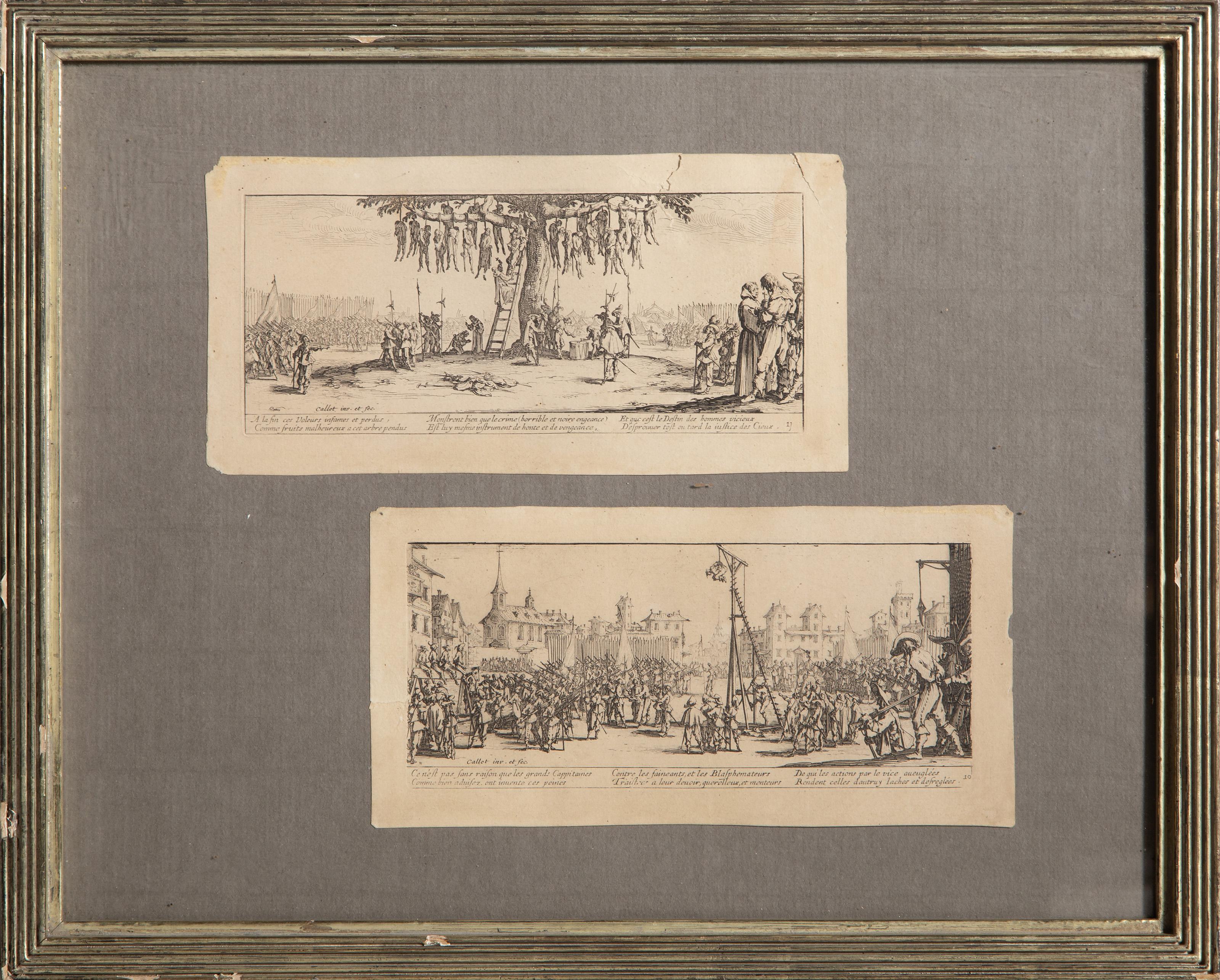
Les Grandes Misères de la Guerre, Old Masters Etching by Jacques Callot
By Jacques Callot
Located in Long Island City, NY
Jacques Callot, French (1592 - 1635) - Les Grandes Miseres de la Guerre (The Miseries of War), Medium: 2 Etchings on paper from Les Grandes Miseres de La Guerre portfolio, Image Size...
Category
Early 17th Century Baroque Prints and Multiples
Materials
Etching
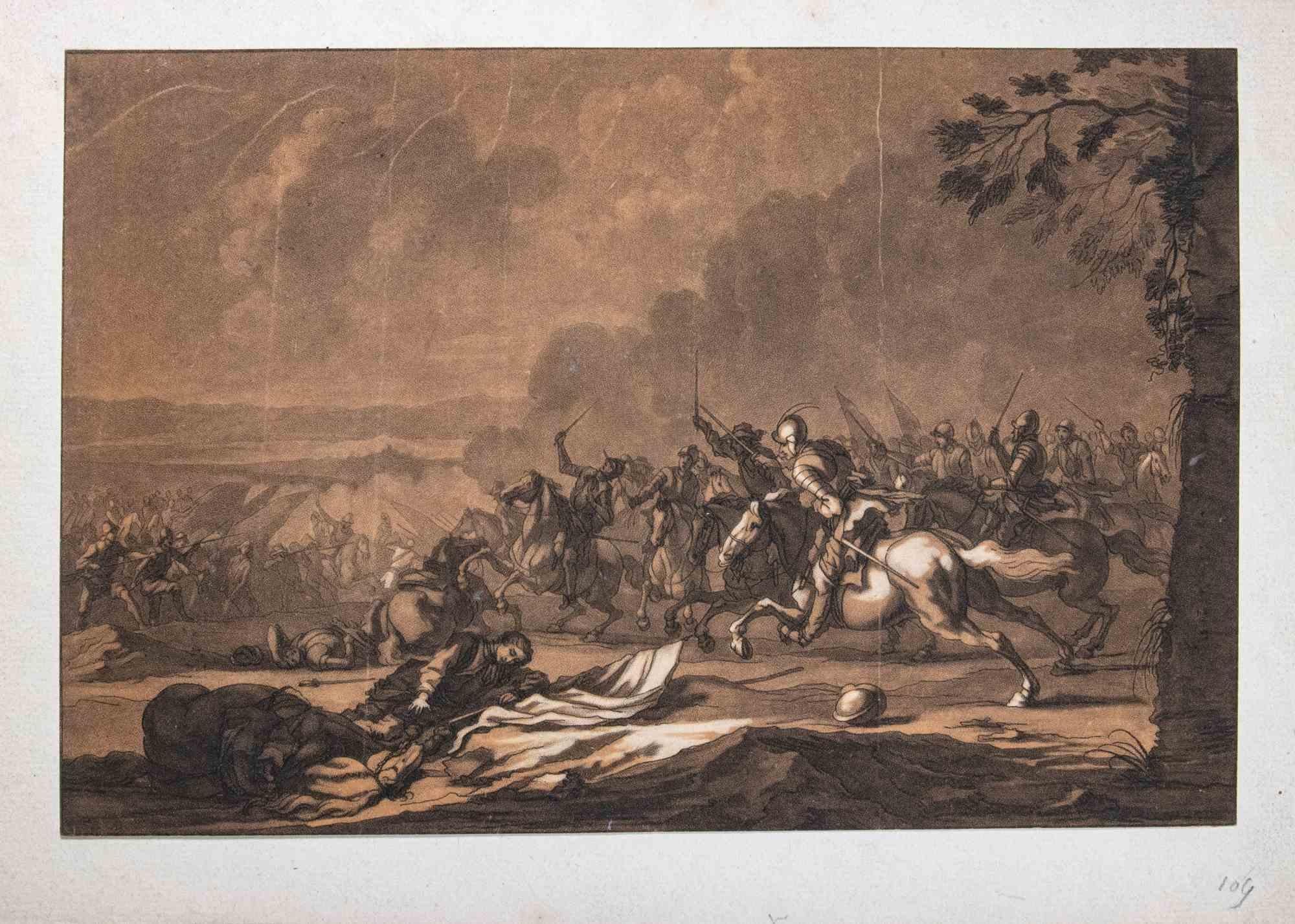
Battle Scene - Original Etching by Christian Johann Rugendas- 18th Century
By François Bonvin
Located in Roma, IT
Battle scene is an original print, realized in mid-18th. Century by the German artist Christian Johann Rugendas (1708-1781) .
Tching and Aquatint on paper. Passpartout included 35x5...
Category
18th Century Modern Figurative Prints
Materials
Etching
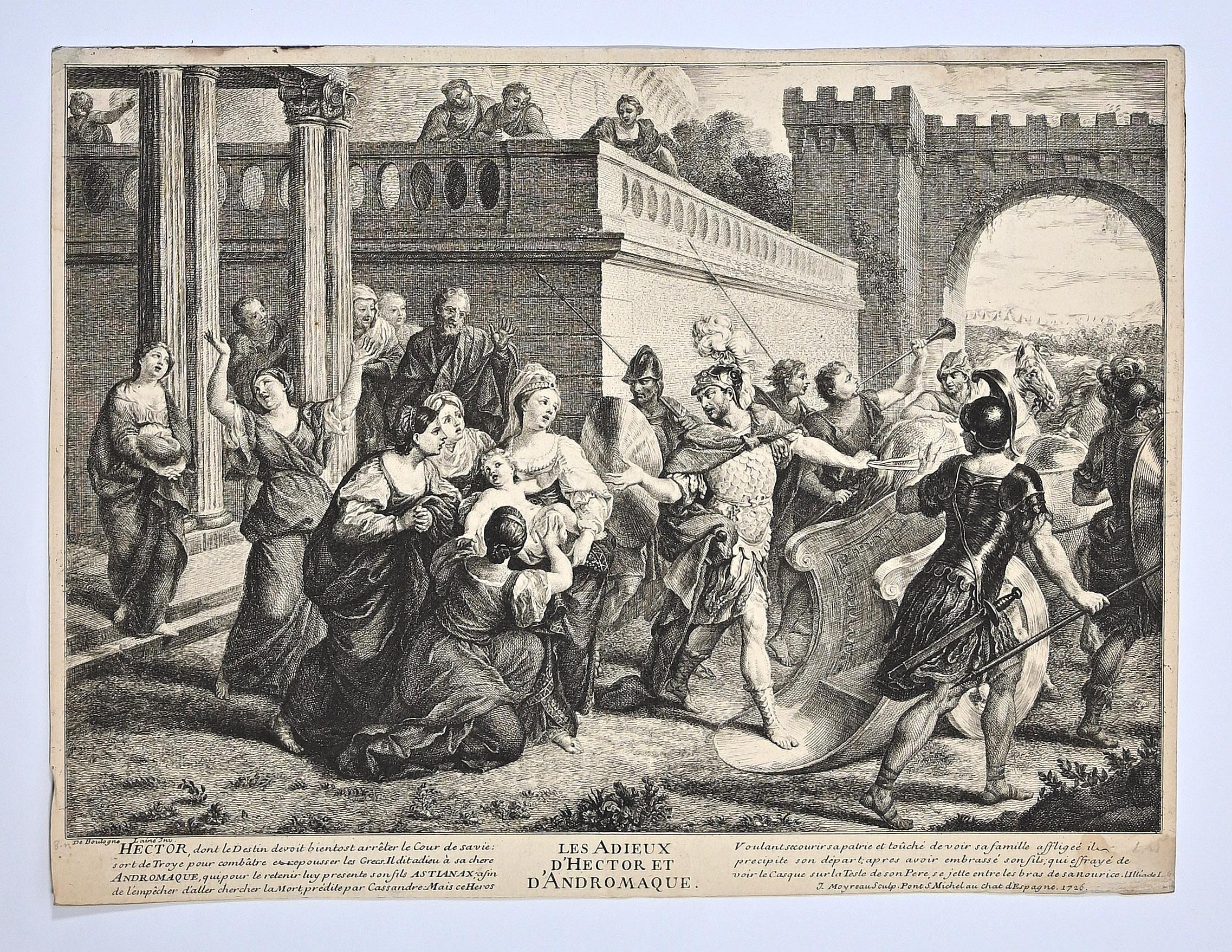
Les Adieux d'Hector d'Andromaque - Etching by Jean Moyreau - 18th Century
By Jean Moyreau
Located in Roma, IT
Les Adieux d'Hector d'Andromaque is an etching realized by Jean Moyreau in the 18th Century.
Good conditions.
The artwork is depicted through soft strokes in a well balanced condit...
Category
Late 18th Century Old Masters Figurative Prints
Materials
Etching
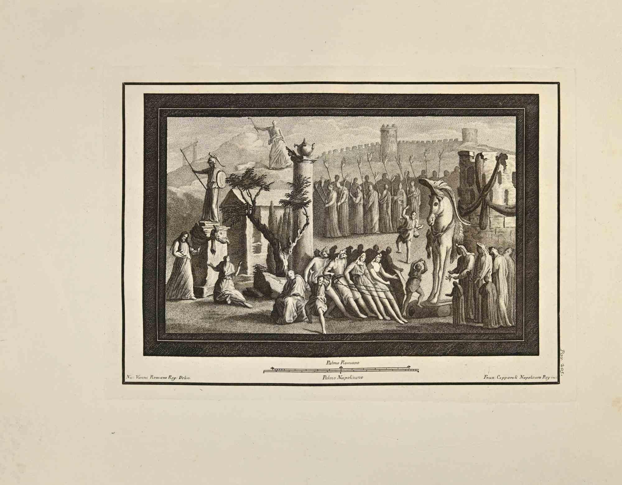
Victory In Roman Empire - Etching by Francesco Cepparoli - 18th Century
By Francesco Cepparoli
Located in Roma, IT
Victory In Roman Empire Fresco from "Antiquities of Herculaneum" is an etching on paper realized by Francesco Cepparoli in the 18th Century.
Signed on the plate.
Good conditions wi...
Category
Late 18th Century Old Masters Figurative Prints
Materials
Etching
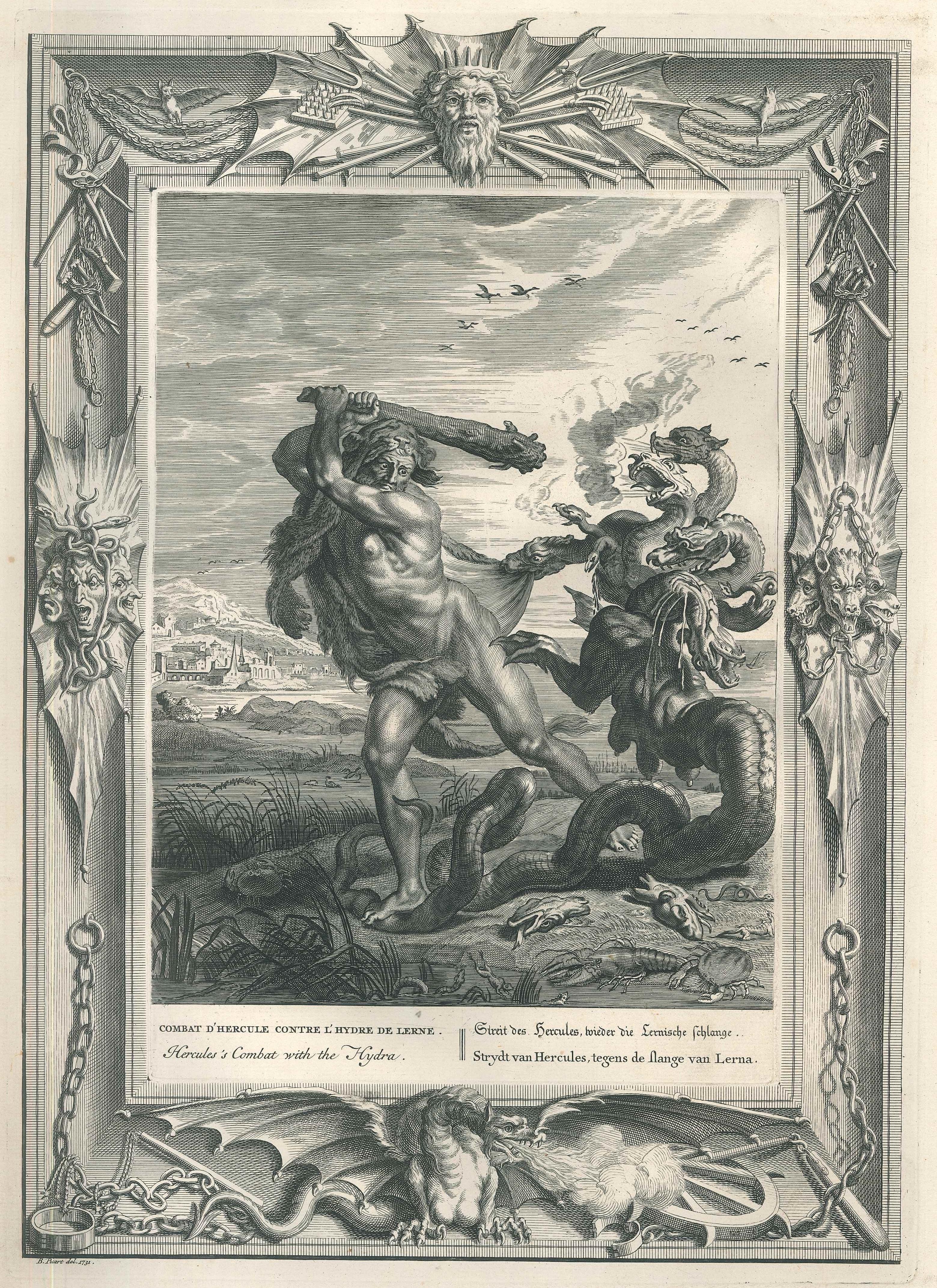
Combat d'Hercule, from "Temple des Muses" - Original Etching by B. Picart - 1742
By Bernard Picart
Located in Roma, IT
Black and white etching on wire rod paper, representing the fight of Hercules against Hydra.
Beautiful plate with very fresh impression, from the volume “Le Temple des Muses”, publi...
Category
1740s Old Masters Figurative Prints
Materials
Etching

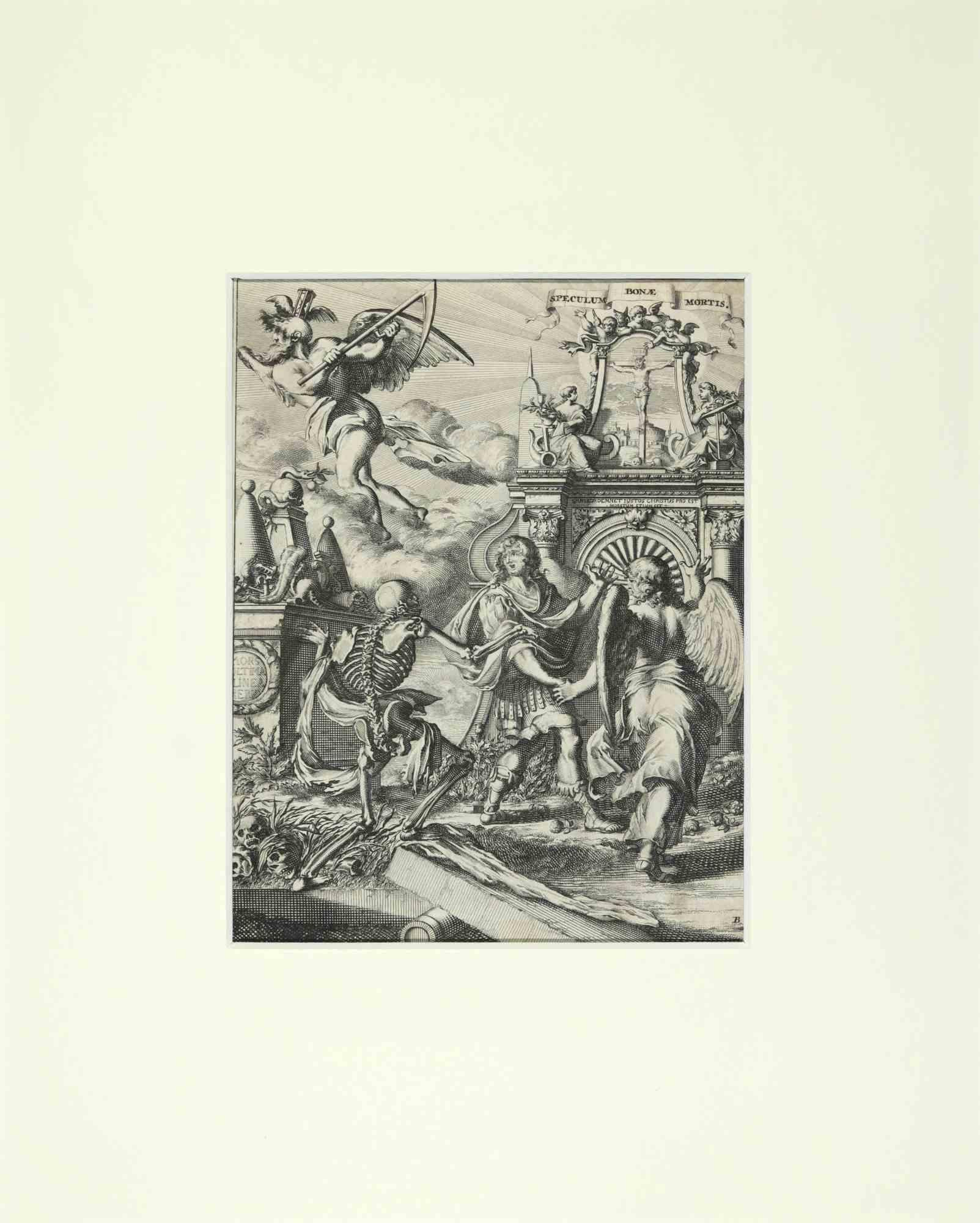
La Manière de se Bien Preparer à La Mort - Etching by Romeyn de Hooghe - 1700
By Romeyn de Hooghe
Located in Roma, IT
La Manière de se Bien Preparer à La Mort is an etching by Romeyn de Hooghe from the Suite by Chertablon de la Vigne, La manière de se bien preparer à la mort. Antwerp: Gallet 1700. ...
Category
Early 1700s Modern Figurative Prints
Materials
Etching
More Ways To Browse
Antique Engraving Plates
Copper Engraving Plate
King Louis Xiv
Antique Handwriting
Painting Drummer
Pop Art Dog Sculpture
Robert Peel
Saxophone Art
Stratford Upon Avon
Tarkay Original
Van Gogh Drawings
Wpa Sign
Balloon Rabbit
Bearbrick 1000
Benson Signed
Bronze Abstract Horse
Burnt Wood Sculpture
Cat Pastel Paintings