Items Similar to Map of Cambridge, c.1572 engraving by Braun & Hogenberg

Want more images or videos?
Request additional images or videos from the seller
1 of 9
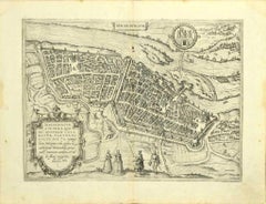
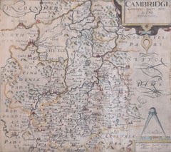
Braun & HogenbergMap of Cambridge, c.1572 engraving by Braun & Hogenbergc.1572
c.1572
$3,006.68
£2,250
€2,610.08
CA$4,240.21
A$4,658.63
CHF 2,434.63
MX$55,557.99
NOK 30,828.97
SEK 28,719.78
DKK 19,503.72
About the Item
To see our other views of Oxford and Cambridge, scroll down to "More from this Seller" and below it click on "See all from this Seller" - or send us a message if you cannot find the view you want.
Braun & Hogenberg
Map of Cambridge
Engraving with later hand colouring
34 x 45 cm
This map is taken from the Civitates Orbit Terrarium, also known as the ‘Braun & Hogenberg.’ This work is the culmination of a fifty year collaboration between Braun and Hogenberg, containing 546 prospects, bird’s-eye views and maps of cities from all around the world. Of these 546 works, 363 were engravings and this particular edition stands out as one of the beautiful and vibrant maps treated to meticulous hand-colouring.
Georg Braun was born in Cologne in 1541 and worked as a topo-geographer. As principal editor of the work, he acquired the tables, hired the artists and cartographers and wrote the texts, including the Latin article on ‘Cantabrigia’ found on the reverse of this engraving. He died as an octogenarian in 1622, the only survivor of the original team to witness the publication of volume VI.
Frans Hogenberg was born in 1535 in Mechelen in Flanders and worked as a painter, engraver and mapmaker. He was notably exiled from Antwerp in 1568 by the Duke of Alva because he was Protestant and had printed engravings sympathising with the Beeldenstorm (the Great Iconoclasm, a historical event in which many forms of church fittings and decoration were destroyed as part of the Protestant Reformation). He then moved to London for a brief period before settling in Cologne, where he worked with Braun on the Civitates.
- Creator:Braun & Hogenberg
- Creation Year:c.1572
- Dimensions:Height: 13.39 in (34 cm)Width: 17.72 in (45 cm)
- Medium:
- Movement & Style:
- Period:
- Condition:Generally very good.
- Gallery Location:London, GB
- Reference Number:1stDibs: LU795315516302
About the Seller
4.8
Vetted Professional Seller
Every seller passes strict standards for authenticity and reliability
Established in 2014
1stDibs seller since 2017
361 sales on 1stDibs
Typical response time: 13 hours
- ShippingRetrieving quote...Shipping from: London, United Kingdom
- Return Policy
More From This Seller
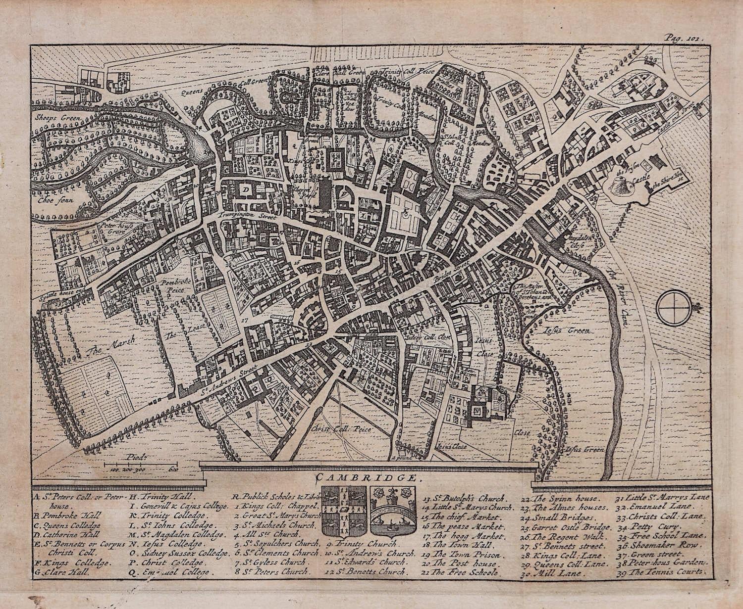
View AllMap of Cambridge, engraving Pieter van der Aa after David Loggan
By Pieter Van Der Aa
Located in London, GB
Pieter van der Aa (1659 - 1733), after David Loggan (1634 - 1692)
Map of Cambridge
Engraving
12 x 16 cm
An eighteenth-century view of Cambridge, engraved by Pieter van der Aa after ...
Category
Early 18th Century Realist Prints and Multiples
Materials
Engraving

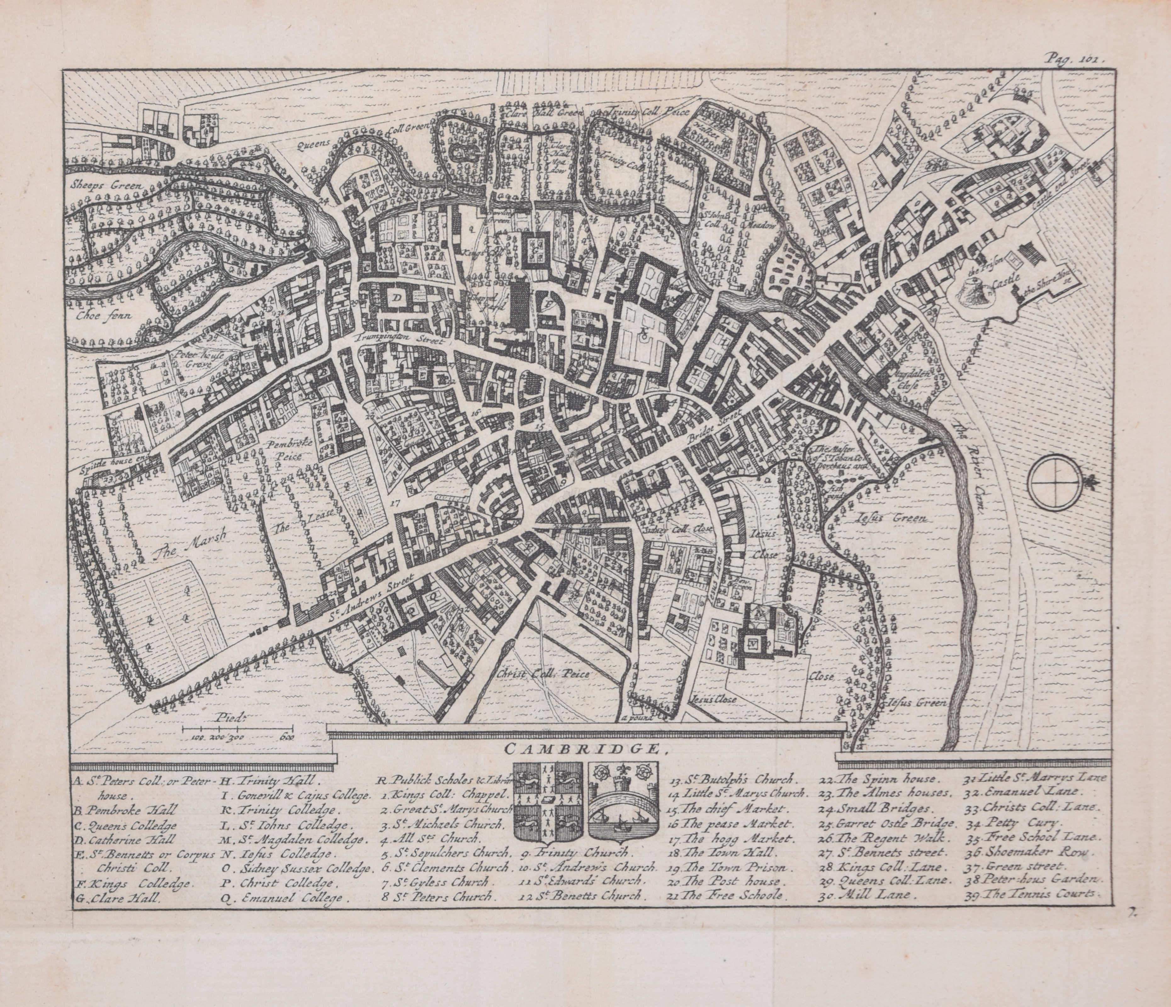
Pieter van der Aa: Map of Cambridge, after David Loggan
By Pieter Van Der Aa
Located in London, GB
Pieter van der Aa (1659-1733), after David Loggan (1634–1692)
Map of Cambridge
12 x 16 cm
Engraving (1727)
An eighteenth-century map of Cambridge eng...
Category
Early 18th Century Realist Prints and Multiples
Materials
Engraving

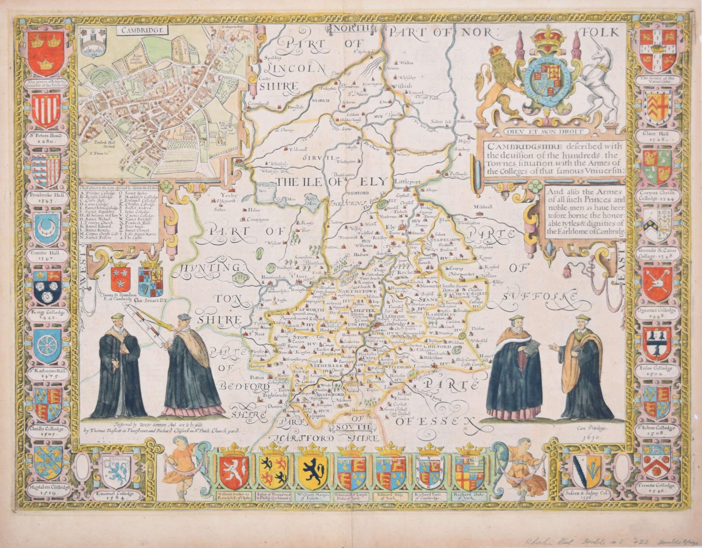
Cambridgeshire map 17th century engraving by John Speed
By John Speed
Located in London, GB
To see more, scroll down to "More from this Seller" and below it click on "See all from this Seller."
John Speed (1551 or 1552 - 1629)
Map of Cambridgeshire
Engraving with later hand colouring
39 x 53 cm
A beautifully coloured map of Cambridgeshire, with an antique description...
Category
1610s Landscape Prints
Materials
Engraving

Cambridge map 17th century engraving after John Speed
By John Speed
Located in London, GB
To see more, scroll down to "More from this Seller" and below it click on "See all from this Seller."
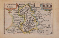
Pieter van den Keere (1571 - circa 1646) after John Speed (1551 or 1552 - 1629)
Map of Cambridgeshire
Engraving
8 x 12 cm
A beautifully coloured map of Cambridgeshire, with an antique description of the county to the reverse. The map, along with many others, was published in Speed's atlas, 'The Theatre of the Empire of Great Britaine', first published in 1611. This particular miniature edition of the 'Theatre' was published in miniature by George Humble in 1627, entitled 'England Wales Scotland and Ireland Described and Abridged With ye Historic Relation of things worthy memory from a farr larger Voulume. Done by John Speed.’ Speed's original map was likely engraved for this edition by Peter van den Keere. van den Keere's maps soon came to be known as "Miniature Speeds".
John Speed was an English cartographer, chronologer and historian. The son of a citizen and Merchant Taylor in London, he rose from his family occupation to accept the task of drawing together and revising the histories, topographies and maps of the Kingdoms of Great Britain as an exposition of the union of their monarchies in the person of King James I and VI. He accomplished this with remarkable success, with the support and assistance of the leading antiquarian scholars of his generation. He drew upon and improved the shire maps of Christopher Saxton, John Norden and others, being the first to incorporate the hundred-boundaries into them, and he was the surveyor and originator of many of the town or city plans inset within them. His work helped to define early modern concepts of British national identity. His Biblical genealogies were also formally associated with the first edition of the King James Bible...
Category
1620s Landscape Prints
Materials
Engraving
Map of Cambridge 18th century engraving by Sutton Nichols
Located in London, GB
To see more, scroll down to "More from this Seller" and below it click on "See all from this Seller."
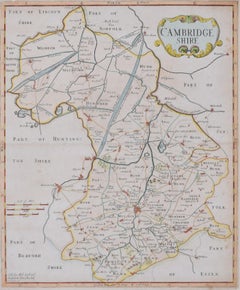
Sutton Nichols (1668 - 1729)
Map of Cambridgeshire
Engraving
43 x 36 cm
Signed in plate lower left.
A beautifully coloured 18th century map engraving of Cambridgeshire. The map was produced by Robert Morden for publication in Edward Gibson's 1695 translation of William Camden's Britannia, a topographical and historical survey of Great Britain and Ireland produced to "restore antiquity to Britaine, and Britain to his antiquity" - a most noble aim.
William Camden (1551 - 1623) was an English antiquarian, historian, topographer, and herald, best known as the author of Britannia, the first chorographical survey of the islands of Great Britain and Ireland, and the Annales, the first detailed historical account of the Queen...
Category
18th Century Landscape Prints
Materials
Engraving
Cambridgeshire map 17th century engraving by Kip after Saxton
Located in London, GB
To see more, scroll down to "More from this Seller" and below it click on "See all from this Seller."
William Kip (active 1598 - 1610) after Christopher Saxton (1540 - 1610).
Map o...
Category
1630s Landscape Prints
Materials
Engraving
You May Also Like
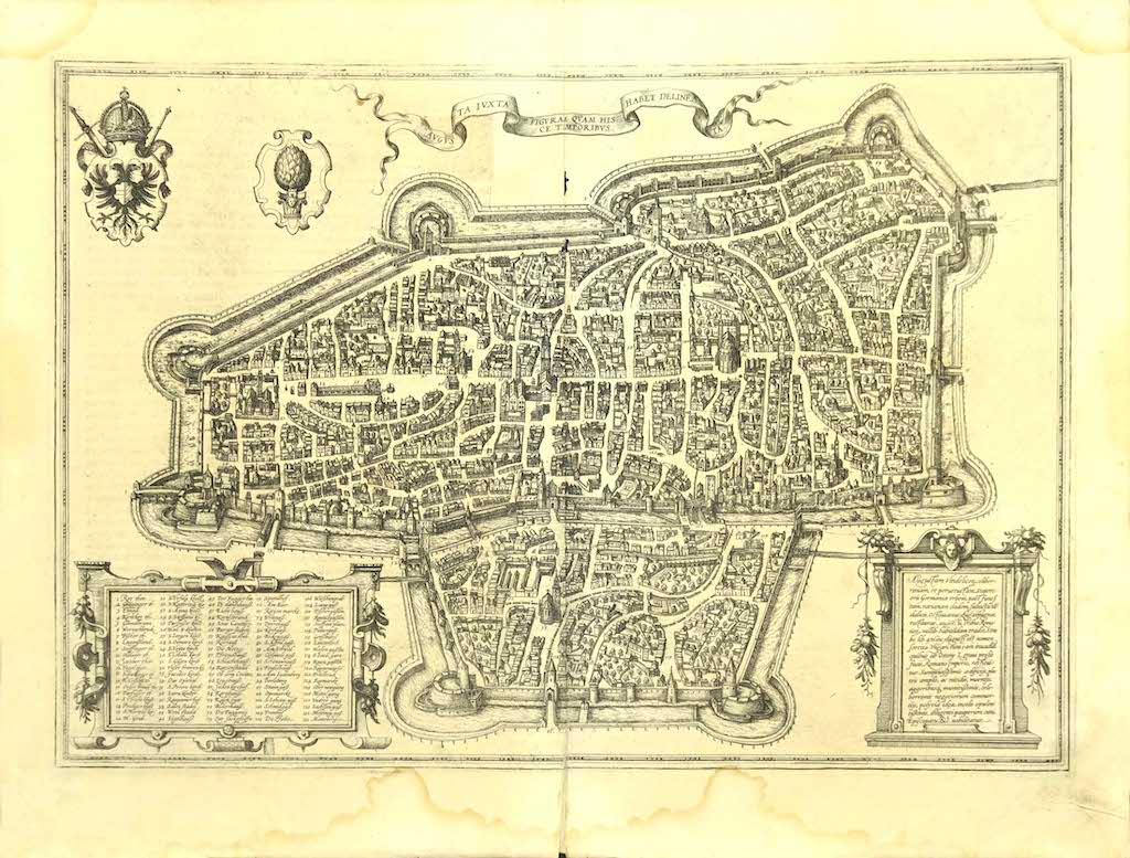
Map of Augsburg - Etching by G. Braun e F. Hogenberg - Late 16th Century
By Franz Hogenberg
Located in Roma, IT
This map of Avgvsta is an original etching realized by George Braun and Franz Hogenberg, as part of the famous series "Civitates Orbis Terrarum (Atlas of the Cities of the World).
...
Category
16th Century Figurative Prints
Materials
Etching
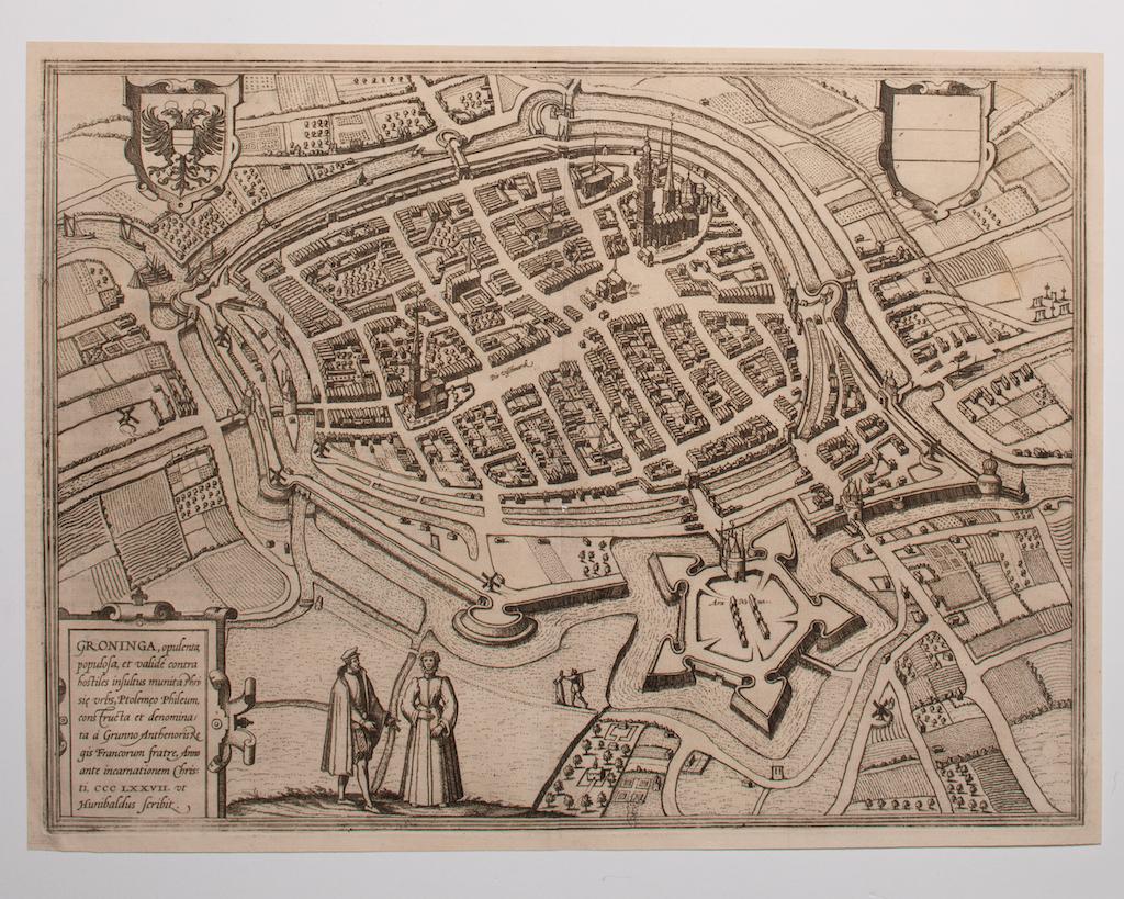
Map of Groningen - Etching by George Braun - Late 16th Century
Located in Roma, IT
This map of Groninga is an original etching realized by George Braun and Franz Hogenberg, and part of the series "Civitates Orbis Terrarum".
The state of preservation of the artwork...
Category
16th Century Figurative Prints
Materials
Etching

Antique Map of the City of Franeker by Bast, 1598
Located in Langweer, NL
Antique map titled 'Franeker'. Very rare and early map of the city of Franeker, Friesland. With decorative cartouche and Dutch legend. Artists and Engravers: Pieter Bast (1550-1605) ...
Category
Antique 16th Century Maps
Materials
Paper
$1,052 Sale Price
20% Off
Oxford, Map from "Civitates Orbis Terrarum" - by F. Hogenberg - 1575
By Franz Hogenberg
Located in Roma, IT
Braun G., Hogenberg F., Oxonium or Oxford, from the collection Civitates Orbis Terrarum, Cologne, T. Graminaeus, 1572-1617.
Very fine and interestig B/W aquatint showing a view of O...
Category
16th Century Figurative Prints
Materials
Etching, Aquatint
Rare Antique Map of Leeuwarden, Friesland, The Netherlands, by P. Bast, 1603
By P. Bast
Located in Langweer, NL
Very rare plan of Leeuwarden, Friesland, The Netherlands. With several cartouches and coat of arms. With a legend and compass rose at bottom right. Made by 'Pieter Bast' after the su...
Category
Antique Early 17th Century Maps
Materials
Paper

$3,436 Sale Price
35% Off
Map of Magdeburg - Etching by G. Braun e F. Hogenberg - Late 16th Century
By Franz Hogenberg
Located in Roma, IT
This map of Magdebvrgvm is an original etching realized by George Braun and Frans Hogenberg, as part of the famous series "Civitates Orbis Terrarum" (Atlas of the Cities of the Worl...
Category
16th Century Figurative Prints
Materials
Etching