Items Similar to Original Southern California Home Federal Fun Map vintage poster
Want more images or videos?
Request additional images or videos from the seller
1 of 8
Darrel MillsapOriginal Southern California Home Federal Fun Map vintage poster1973
1973
$559.20
$69920% Off
£422.57
£528.2120% Off
€487.96
€609.9520% Off
CA$781.40
CA$976.7520% Off
A$867.03
A$1,083.7820% Off
CHF 454.17
CHF 567.7120% Off
MX$10,632.07
MX$13,290.0920% Off
NOK 5,776.85
NOK 7,221.0620% Off
SEK 5,453.10
SEK 6,816.3720% Off
DKK 3,639.05
DKK 4,548.8120% Off
Shipping
Retrieving quote...The 1stDibs Promise:
Authenticity Guarantee,
Money-Back Guarantee,
24-Hour Cancellation
About the Item
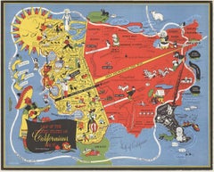
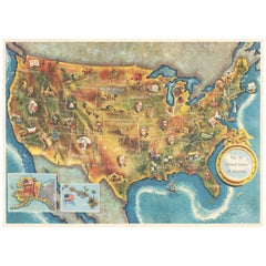
Original California Fun Map vintage poster from 1973. Archival linen backed in fine condition that is ready to frame.
Artist: Darrel Millsap.
This fun map of California shows about everything and everywhere there are things to do in the state. From the bottom border with Mexico, the map goes north to the Redwood National Forest, Marble Mountain Wilderness, and Lava Bed National Monument. Naturally, it includes the areas of San Diego and the attractions, Los Angles and the music and sports areas, and San Francisco and the Golden Gate Bridge.
The various images will give you more detailed shots of various sections of this vintage poster. Something for you to study and enjoy in any room in your home.
This is an Original Lithograph Vintage Poster; it is not a reproduction.
- Creator:Darrel Millsap (1931 - 2012, American)
- Creation Year:1973
- Dimensions:Height: 38 in (96.52 cm)Width: 24.5 in (62.23 cm)Depth: 0.05 in (1.27 mm)
- Medium:
- Movement & Style:
- Period:
- Condition:FREE Continental USA shipping. Certificate of Authenticity with an embedded image of the artwork. Conservation linen-backed and ready to frame. A condition.
- Gallery Location:Spokane, WA
- Reference Number:Seller: 230531stDibs: LU1404210146162
About the Seller
5.0
Platinum Seller
Premium sellers with a 4.7+ rating and 24-hour response times
Established in 1998
1stDibs seller since 2020
241 sales on 1stDibs
Typical response time: 1 hour
- ShippingRetrieving quote...Shipping from: Spokane, WA
- Return Policy
Authenticity Guarantee
In the unlikely event there’s an issue with an item’s authenticity, contact us within 1 year for a full refund. DetailsMoney-Back Guarantee
If your item is not as described, is damaged in transit, or does not arrive, contact us within 7 days for a full refund. Details24-Hour Cancellation
You have a 24-hour grace period in which to reconsider your purchase, with no questions asked.Vetted Professional Sellers
Our world-class sellers must adhere to strict standards for service and quality, maintaining the integrity of our listings.Price-Match Guarantee
If you find that a seller listed the same item for a lower price elsewhere, we’ll match it.Trusted Global Delivery
Our best-in-class carrier network provides specialized shipping options worldwide, including custom delivery.More From This Seller
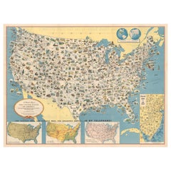
View AllOriginal 'Map of the United States as Californians See It' vintage map poster
Located in Spokane, WA
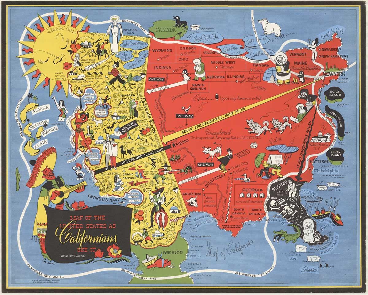
Original vintage poster: "Map of the United States as Californians See It". 1947, artist: Oren Arnold. Size: 16.5" x 20.5", R. H. MOEBUS COMPANY This poster is not linen-backed. This poster is in very good fine condition, ready to frame.
A humorous satirical pictorial map from 1947 with the golden sun on the upper left, gives a detailed depiction of California, its relative size to the rest of the United States, showing Florida as "Death Valley", the rest of the United States as "Unexplored" 'Unimportant anyway, not in California". The image has your Mexican singer; bikini-clad bathers and others set in the image. Shows rivers, lakes, harbors, landmarks, parks, recreational activities, and local people.
This map shows Los Angeles’ city...
Category
1940s American Modern Landscape Prints
Materials
Offset
$1,280 Sale Price
20% Off
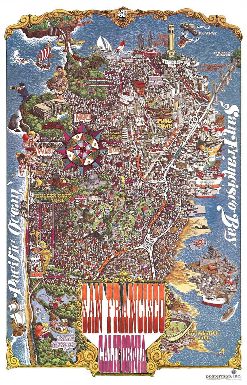
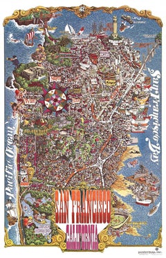
Original San Francisco, California vintage fun map poster Henry Hinton
Located in Spokane, WA
Original San Francisco, California fun map vintage poster 1970. Archival linen backed in very fine condition, ready to frame.
-Artist: Henry Hinton
I don’t know how much more you could include in this detailed fun map of San Francisco...
Category
1970s American Impressionist Landscape Prints
Materials
Offset
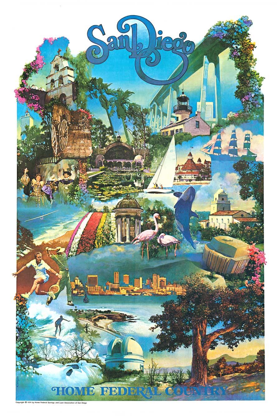
Original San Diego (Home Federal) 1974 vintage poster
Located in Spokane, WA
Original travel poster: San Diego (Home Federal), artist: Robert Kinyon, 24.25" x 38", 1974; original Southern California poster. Excellent condi...
Category
1970s American Modern Landscape Prints
Materials
Offset
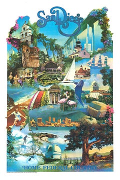
$476 Sale Price
20% Off
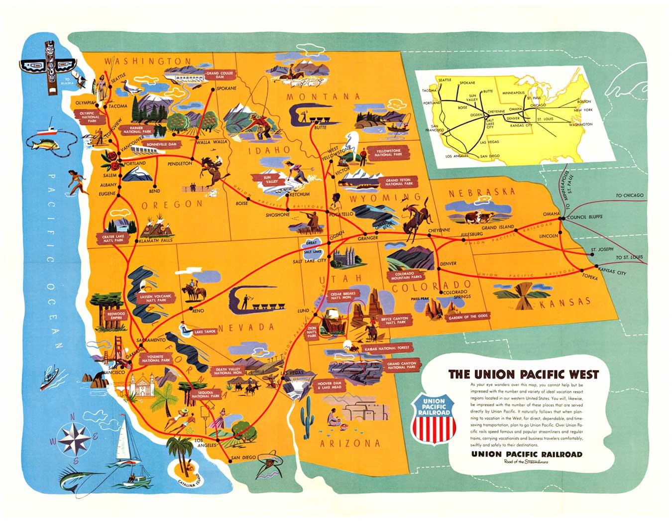
Union Pacific West vintage fun map railroad travel poster
Located in Spokane, WA
Original “The Union Pacific West fun map, archivally linen backed in very good condition. Ready to frame. This was initially folded, and the fold marks were ...
Category
1960s American Modern Landscape Prints
Materials
Offset

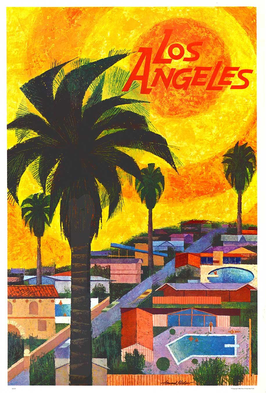
Original Los Angeles (California) 1964 vintage travel poster Mid Century Modern
Located in Spokane, WA
Original 1964 Los Angeles, California vintage travel poster. Professionally archivally linen-backed in mint condition. This is one of four ...
Category
1960s American Modern Landscape Prints
Materials
Offset

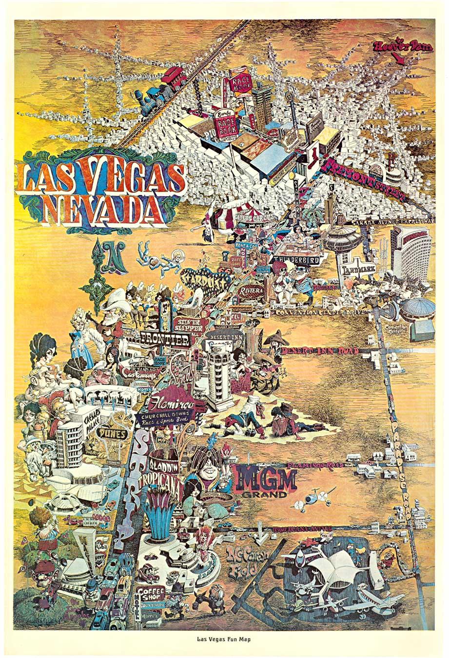
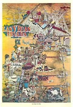
Original Las Vegas Fun Map vintage 1970s travel poster
Located in Spokane, WA
Original 1970s Las Vegas Fun Map. Archival linen backed and in very good condition, ready to frame. The poster is not signed by is presumed to be done by “King”. Size: 22 5/8" x 34"
The linen backing corrected the pin holes in the poster, and the borders were restored. The edge tear was restored. The color matches the known existing copy, which is housed at Standford. B condition.
As you venture down the strip in this vintage Las Vegas Fun Map, you will find the Tropicana, Aladdin, the old MGM Grand...
Category
1970s American Modern Landscape Prints
Materials
Offset
You May Also Like
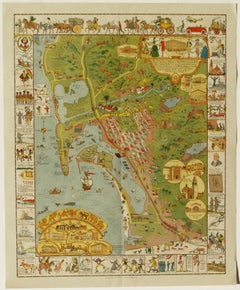
Jo Mora's 1928 "Carte" of San Diego, Very Rare Pictorial Map
Located in Phoenix, AZ
Jo Mora's 1928 "Carte" of San Diego, Very Rare Pictorial Map
Size: 28 x 22.5 in (71.12 x 57.15 cm)
Every good condition for it's age
Originally came folded in envelope for mailing....
Category
1920s Other Art Style More Prints
Materials
Lithograph
California, Northern Part. USA Century Atlas state antique vintage map
Located in Melbourne, Victoria
'The Century Atlas. California, Northern Part'
Inset maps of 'Yosemite Valley' and 'San Francisco and Vicinity'.
Original antique map, 1903.
Central fold as issued. Map name and nu...
Category
Early 20th Century Victorian More Prints
Materials
Lithograph
Large Original Antique Map of California, USA, circa 1900
Located in St Annes, Lancashire
Fabulous map of California
Original color
Engraved and printed by the George F. Cram Company, Indianapolis.
Published, circa 1900
Unframed
Free shipping.
Category
Antique 1890s American Maps
Materials
Paper

American Election Map and 1960 Presidential Fact Sheet, Published 1960
Located in Langweer, NL
Title: “The 50 United States of America”
Subject: United States, Presidential Elections
Date: 1960 (dated)
Color: Printed Color
Size: 24.9 x 17.9 inches (63.2 x 45.5 cm)
This colorful map of the United States was drawn by Lorin Thompson and published by the General Foods Corporation. The map has an unusual coloring style with symbols of American history including past presidents, Native Americans, important buildings (White House, Statue of Liberty, Alamo), agriculture, industry, and more. Includes inset maps of Hawaii and Alaska with small American flags...
Category
Vintage 1960s Posters
Materials
Paper
$572 Sale Price
20% Off
Original Antique Map of the American State of California ( Southern Part ), 1903
Located in St Annes, Lancashire
Antique map of California ( Southern part )
Published By A & C Black. 1903
Original colour
Good condition
Unframed.
Free shipping
Category
Antique Early 1900s English Maps
Materials
Paper

Old Decorative Pictorial Map of the United States, circa 1953
Located in Langweer, NL
Antique map titled 'A Pictorial Map of the United States of America Showing Principal Regional Resources, Products, and Natural Features'.
This information-packed map was create by the General Drafting Company for the New Jersey Bell Telephone Company. The main map features over 700 drawings in full color including points of interest, natural resources, and agricultural products. At bottom are inset maps showing railroad lines, air routes, telephone lines, as well as a pictorial map of New Jersey...
Category
20th Century Maps
Materials
Paper
$715 Sale Price
20% Off
More Ways To Browse
California Redwood
Original Mexican Posters
Vintage Bed Linens
Map Of Mexican California
Antique Currier Ives Prints
De Gloire
Piranesi Veduta
David Roberts Holy Land
Gossamer Vintage
Bernard Buffet 1967
Picasso Affiches
Christ Church Oxford
Topiary Art
Westminster Etching
Antique Almanac
Claude Etching Lorrain
De Micheli
Piranesi Views Of Rome