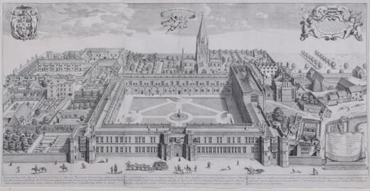
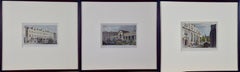
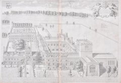
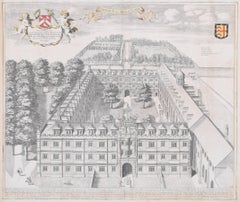
Want more images or videos?
Request additional images or videos from the seller
1 of 5

David Loggan
New College, Oxford, engraving aerial view, 1690 David Loggan

1690

Price:$1,382.76

You May Also Like

1776 Navigational chart/map of the Delaware bay and river including Philadelphia
Located in Philadelphia, PA
JOSHUA FISHER (AMERICAN, EIGHTEENTH CENTURY) A Chart of Delaware Bay and River, 1776 Printed for John Bennet and Robert Sayer, London Engraving on pape...
Category

1770s Realist Landscape Prints

Materials

Paper, Engraving

"A Dance in Otaheite" (Tahiti), Engraving from Captain Cook's 3rd Voyage
By John Webber
Located in Alamo, CA
"A Dance in Otaheite" (Tahiti) is an engraving created by William Sharp (1749-1824), from a drawing by John Webber (1752-1793), who was the artist on Captain James Cook's 3rd and final voyage of discovery. It is a plate in the atlas of "A Voyage to the Pacific Ocean Undertaken by the Command of His Majesty, for Making Discoveries in the Northern Hemisphere", the official British Admirality sanctioned journal published upon completion of the voyage in London in 1784 by Strahan & Cadell. Two women and two men wearing ceremonial costumes, performing a dance outdoors standing on a mat. Three men are playing the drums in the background, in front of a thatched roof building. An audience of men are sitting on both sides of the stage. By the time Webber arrived in Tahiti, 'south sea' imagery had become familiar. Webber gave concentrated attention to dance. He had the opportunity to distinguish the Tahitian dance from the more formalized dancing of Tonga. Whereas they seem to have called to mind the more formal dances of antiquity, the Tahitian dancing aroused memories of peasant and folk dancing. This engraving is professionally framed in Koa wood. Koa wood is legendary in Hawaii. Not only is this amazing wood native to Hawaii, but it is known for the deep rich colors and varied grain pattern. Koa has an honored heritage in Hawaii and is highly revered and sacred. The word “koa” means “warrior” in Hawaiian. The warriors of King Kamehameha the Great, created canoes and weapons from a wood plentiful on the Big Island of Hawaii. This wood became synonymous with the warriors themselves, and it became known as koa. The print is in excellent condition. There are three other engravings listed from the official journal of Captain Cook's 3rd voyage available that are presented in identical Koa wood frames and double mats (LU117324682432, LU117324684052, LU117324684062). They would make a wonderful grouping for a display of 2, 3 or 4 prints. A discount is available for a grouping depending on the number of items included. Hawaii was discovered by Captain Cook during this voyage. Hawaii was originally called The Sandwich Islands in honor of The Earl of Sandwich...
Category

1780s Realist Landscape Prints

Materials

Engraving

Moths in Their Natural Landscape: Antique Hand-colored Engraving by Moses Harris
By Moses Harris
Located in Alamo, CA
This is a hand-colored engraving depicting the natural history of Pinkunderwing Moths, Cream Spotted Tyger Moths in their natural botanical environment, which is plate 4 from Moses H...
Category

Mid-19th Century Realist Landscape Prints

Materials

Engraving

Tortoise-shell Butterfly, Hawk Moth: Antique Hand-colored Engraving by M. Harris
By Moses Harris
Located in Alamo, CA
This is a hand-colored antique engraving depicting the natural history of the Tortoise-shell Butterfly and Privet Hawk Moth, which is plate 2 from Moses Harris' publication "The Aure...
Category

Mid-19th Century Realist Landscape Prints

Materials

Engraving

Moths and a Lady Bug in a Landscape: A Hand-colored Engraving by Moses Harris
By Moses Harris
Located in Alamo, CA
This is a hand-colored engraving depicting the natural history of moths and a lady bug, which is plate 22 from Moses Harris' publication "The Aurelian: or Natural History of English Insects; Namely Moths & Butterflies", first published in London in 1766 and this from an 1840 edition. The engraving depicts the natural history developmental stages of the Burnished Brass Moth, the Dark Gothic...
Category

Mid-19th Century Realist Landscape Prints

Materials

Engraving

Admirable Butterflies, Magpie Moths: A Hand-colored Engraving by Moses Harris
By Moses Harris
Located in Alamo, CA
This is a hand-colored antique engraving depicting the natural history of the Admirable Butterfly and the Small Magpie Moth, which is plate 6 from Moses Harris' publication "The Aure...
Category

Mid-19th Century Realist Landscape Prints

Materials

Engraving

Butterflies & Moths in Nature: An Antique Hand-colored Engraving by Moses Harris
By Moses Harris
Located in Alamo, CA
This is a hand-colored antique engraving depicting the natural history of the the Brown Hairstreak Butterfly, the Larke Skipper Butterfly, the Small Skipper Butterfly, the Scarce Mar...
Category

Mid-19th Century Realist Landscape Prints

Materials

Engraving

Three 19th C. Hand Colored Engravings of London Architecture by T. Shepherd
By Thomas Hosmer Shepherd
Located in Alamo, CA
A set of three hand-colored engravings from "Metropolitan Improvements; or London in the Nineteenth Century", published in London, England in 1828. The scenes were drawn by Thomas Ho...
Category

1820s Realist Landscape Prints

Materials

Engraving

'Sister, A portrait of the Moon' , Signed Etching c2021
Located in Frome, Somerset
'Sister' , by contemporary printmaker and artist Rosie McLay (British) Edition 59 of 75 in total, handmade etching by the artist. Ink on paper layed on Dutch gold leaf. Hand etched ...
Category

2010s Realist Landscape Prints

Materials

Engraving

William Hogarth . Original engravings 155 pсs., 1 piece with blend. 1822 London
By William Hogarth
Located in Riga, LV
William Hogarth (1697-1764) Original engravings 155 pсs., 1 piece with blend. 1822 London From A. Neibergs collection
Category

1820s Realist Figurative Prints

Materials

Paper, Engraving

More From This Seller

View All
David Loggan Trinity College Cambridge Bishop's Hostel engraving 1690
By David Loggan
Located in London, GB
To see our other views of Oxford and Cambridge, scroll down to "More from this Seller" and below it click on "See all from this Seller" - or send us a message if you cannot find the view you want. David Loggan (1634-1692) The Bishop's Hostal, Trinity College Cambridge...
Category

1690s Realist Prints and Multiples

Materials

Engraving

Trinity College, Cambridge engraving by David Loggan
By David Loggan
Located in London, GB
To see our other views of Oxford and Cambridge, scroll down to "More from this Seller" and below it click on "See all from this seller" - or send us a message if you cannot find the view you want. David Loggan (1634 - 1692) Trinity College, Cambridge (1690) Engraving 80 x 50 cm Loggan's marvellous and large view of Trinity from the 'Cantabrigia Illustrata'. Loggan was born to English and Scottish parents, and was baptised in Danzig in 1634. After studying engraving in Danzig with Willem Hondius (1598-1652 or 1658), he moved to London in the late 1650s, going on to produce the engraved title-page for the folio 1662 Book of Common Prayer. He married in 1663 and moved to Nuffield in Oxfordshire in 1665. Loggan was appointed Public Sculptor to the nearby University of Oxford in the late 1660s, having been commissioned to produce bird’s-eye views of all the Oxford colleges. He lived in Holywell Street as he did this. The 'Oxonia Illustrata' was published in 1675, with the help of Robert White (1645-1704). Following its completion, Loggan began work on his equivalent work for Cambridge; the 'Cantabrigia Illustrata' was finally published in 1690, when he was made engraver to Cambridge University. The 'Oxonia Illustrata' also includes an engraving of Winchester College (Winchester and New College share William of Wykeham as their founder) whilst the 'Cantabrigia Illustrata' includes one of Eton College (which shares its founder, Henry VIII, with King’s College). Bird’s-eye views from this era required a particular talent as an architectural perspectivist; it was not until 1783 that it became possible for artists to ascend via hot air balloons and view the scenes they were depicting from above. Loggan thus had to rely on his imagination in conceiving the views. Loggan’s views constitute the first accurate depictions of the two Universities, in many ways unchanged today. Whilst the Oxford engravings were produced in reasonable numbers and ran to a second edition by Henry Overton (on thicker paper and with a plate number in Roman numerals in the bottom right-hand corner), those of Cambridge were printed in much smaller numbers. The Dutchman Pieter van der Aa published some miniature versions of the engravings for James Beverell’s guidebook to the UK, 'Les Delices de la Grande Bretagne' (circa 1708). The contemporary artist Andrew Ingamells...
Category

1690s Realist Landscape Prints

Materials

Engraving

John Speede, Map of the County of Surrey, described and divided into hundreds
By John Speed
Located in London, GB
To see our other views and maps of England - including London, Oxford and Cambridge, scroll down to "More from this Seller" and below it click on "See all from this Seller" - or send us a message if you cannot find the view you want. John Speed/Speede (1551/2-1629) The County of Surrey Described and Divided into Hundreds Engraving with later hand colouring and text to the reverse.  Dated to c.1650 36 x 49 cm Probably the most famous early English mapmaker, John Speed's early life is somewhat of an enigma. He is believed to have trained as a rolling-press printer, but he was at heart an historian granted a sinecure in the Customs House by Queen Elizabeth to indulge his passion, later becoming a Fellow of the Society of Antiquaries. His first maps were historical, of the Holy Land 'Canaan as it was Possessed both in Abraham and Israels Dayes' and of England and Ireland recording 'all their Civill Warres since the Conquest'. In 1611 he published his 'Hostory of Great Britaine' which he regarded as his magnum opus, but it was the companion atlas 'Theatre of the Empire of Great Britaine' that - as the first printed atlas of Great Britain - sealed his reputation. William Rogers engraved the first map, 'the County Palatine of Chester' in about 1600, but following his untimely death the task of engraving was passed to Jodocus Hondius of Amsterdam. By 1612 the atlas was complete, the maps famed for their decorative elements. Many have town plans - Britain's first series of such plans - and descriptive text was printed to the reverse until the 1676 edition. Later printings (up until 1770) were issued without this text. By 1627 it has become a part of a world atlas 'Prospect of the Most Famous Parts of the World'. During the 17th century the plates passed through the hands of a series of publishers, the 1676 edition of Thomas Bassett and Richard Chiswell being regarded as its high point with the inclusion for the first time of a series of important maps. For the first half of the eighteenth century they were firmly established in the hands of the Overton family. This particular edition originally featured in The Theatre Of The Empire Of Great Britaine. It features attractive inset views of the long-since destroyed Richmond...
Category

17th Century Realist Landscape Prints

Materials

Engraving

Engraved 18th century view of Cambridge
Located in London, GB
18th Century View of Cambridge Engraving 15 x 20 cm This detailed engraving captures an 18th century view of Cambridge from the West. Green expanses dominate the piece, featuring s...
Category

18th Century Realist Landscape Prints

Materials

Engraving

Pembroke College, Oxford 1705 engraving by David Loggan
By David Loggan
Located in London, GB
To see our other views of Oxford and Cambridge, scroll down to "More from this Seller" and below it click on "See all from this seller" - or send us a message if you cannot find the view you want. David Loggan (1634 - 1692) Pembroke College, Oxford (1705) Engraving 31 x 44 cm Loggan's view of Pembroke from the second edition of the 'Oxonia Illustrata'. Loggan was born to English and Scottish parents, and was baptised in Danzig in 1634. After studying engraving in Danzig with Willem Hondius (1598-1652 or 1658), he moved to London in the late 1650s, going on to produce the engraved title-page for the folio 1662 Book of Common Prayer. He married in 1663 and moved to Nuffield in Oxfordshire in 1665. Loggan was appointed Public Sculptor to the nearby University of Oxford in the late 1660s, having been commissioned to produce bird’s-eye views of all the Oxford colleges. He lived in Holywell Street as he did this. The 'Oxonia Illustrata' was published in 1675, with the help of Robert White (1645-1704). Following its completion, Loggan began work on his equivalent work for Cambridge; the 'Cantabrigia Illustrata' was finally published in 1690, when he was made engraver to Cambridge University. The 'Oxonia Illustrata' also includes an engraving of Winchester College (Winchester and New College share William of Wykeham as their founder) whilst the 'Cantabrigia Illustrata' includes one of Eton College (which shares its founder, Henry VIII, with King’s College). Bird’s-eye views from this era required a particular talent as an architectural perspectivist; it was not until 1783 that it became possible for artists to ascend via hot air balloons and view the scenes they were depicting from above. Loggan thus had to rely on his imagination in conceiving the views. Loggan’s views constitute the first accurate depictions of the two Universities, in many ways unchanged today. Whilst the Oxford engravings were produced in reasonable numbers and ran to a second edition by Henry Overton (on thicker paper and with a plate number in Roman numerals in the bottom right-hand corner), those of Cambridge were printed in much smaller numbers. The Dutchman Pieter van der Aa published some miniature versions of the engravings for James Beverell’s guidebook to the UK, 'Les Delices de la Grande Bretagne' (circa 1708). The contemporary artist Andrew Ingamells...
Category

1670s Realist Landscape Prints

Materials

Engraving

Map of Cambridge, c.1572 engraving by Braun & Hogenberg
Located in London, GB
To see our other views of Oxford and Cambridge, scroll down to "More from this Seller" and below it click on "See all from this Seller" - or send us a message if you cannot find the ...
Category

16th Century Realist Landscape Prints

Materials

Engraving

Recently Viewed

View All