Want more images or videos?
Request additional images or videos from the seller
1 of 13
Jacques Nicolas BellinBellin 18th Century Hand Colored Map of St. Christophe (St. Kitts)1760
1760
$675List Price
About the Item
- Creator:Jacques Nicolas Bellin (1703 - 1772)
- Creation Year:1760
- Dimensions:Height: 13.13 in (33.36 cm)Width: 17 in (43.18 cm)Depth: 0.75 in (1.91 cm)
- Medium:
- Period:
- Condition:
- Gallery Location:Alamo, CA
- Reference Number:Seller: #31321stDibs: LU117325431681
About the Seller
5.0
Platinum Seller
Premium sellers with a 4.7+ rating and 24-hour response times
Established in 2011
1stDibs seller since 2019
298 sales on 1stDibs
Typical response time: 1 hour
Authenticity Guarantee
In the unlikely event there’s an issue with an item’s authenticity, contact us within 1 year for a full refund. DetailsMoney-Back Guarantee
If your item is not as described, is damaged in transit, or does not arrive, contact us within 7 days for a full refund. Details24-Hour Cancellation
You have a 24-hour grace period in which to reconsider your purchase, with no questions asked.Vetted Professional Sellers
Our world-class sellers must adhere to strict standards for service and quality, maintaining the integrity of our listings.Price-Match Guarantee
If you find that a seller listed the same item for a lower price elsewhere, we’ll match it.Trusted Global Delivery
Our best-in-class carrier network provides specialized shipping options worldwide, including custom delivery.You May Also Like
After Giovanni Battista Piranesi - 20th Century Engraving, Plautii Mausoleum
Located in Corsham, GB
A charming engraving with etched details. Inscribed in plate. Presented in a painted black and gold gilt frame. On paper.
Category
20th Century Landscape Prints
Materials
Engraving
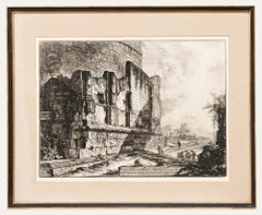
$439
H 26.78 in W 33.08 in
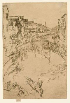
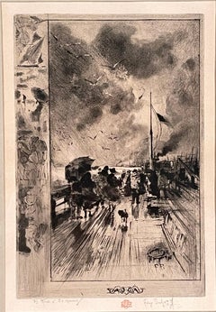
The Bridge, Santa Maria
By James Abbott McNeill Whistler
Located in New York, NY
James Whistler (1834-1903), The Bridge, Santa Marta, 1879-80, etching with drypoint, printed in sepia on fine laid paper. Signed with the butterfly and inscribed imp on the tab (also with an exceedingly light butterfly lower right in the plate). Kennedy 204, probably eighth (final) state; Glasgow 201, probably state 9 (of 9) (cf. Margaret F. MacDonald, Grischka Petri, Meg Hausberg, and Joanna Meacock, James McNeill Whistler: The Etchings, a catalogue raisonné, University of Glasgow, 2011), Lochnan 199. Trimmed to the platemark by the artist, h: 11.8 x w: 7.9 in / h: 30 x w: 20.1 cm.
A fine impression, printed with subtle tone.
The bridge theme occurs repeatedly in Whistler’s vistas. It is also the main focus of more than one of the Venetian prints. While some bridges are seen from below, from where one would see it if approaching in a gondola (for example Ponte del Piovan, Kennedy 209), The Bridge depicts the scene from a high perspective, opening up the view into the far distance. The small boat approaching the arch in the foreground is again, as in the earlier Thames prints, a stock motif that is probably ultimately derived from the Japanese woodcuts of Hokusai and Hiroshige. The bridge here is the Ponte de le Terese over the Rio de l’Arzere in the Santa Marta quarter.
The early biography of Whistler by Elizabeth and Joseph Pennell is essential for its “immense quantity of information” but also notorious for “the inherent hyperbole and misinformation” (Eric Denker, Annotated Bibliography, in Fine, p. 184). Still, it is worth quoting from the Pennels’ appraisal of The Bridge: “Simplicity of expression has never been carried further. Probably the finest plate, in its simplicity and directness, is The Bridge. Whistler now obtained the quality of richness by suggesting detail, and also by printing. In The Traghetto...
Category
1870s Impressionist Landscape Prints
Materials
Drypoint, Etching
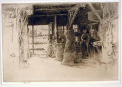
The Mill, Amsterdam, 1889
By James Abbott McNeill Whistler
Located in New York, NY
James Whistler (1834-1903), The Mill, 1889, etching and drypoint, signed in pencil with the butterfly on the tab and inscribed “imp”, and inscribed “first state” (twice) and annotated “Wunderlich” and signed again with the butterfly verso. Reference: Kennedy 413, first state (of 5). Glasgow 457, second state (of 6; see discussion below) (cf. Margaret F. MacDonald, Grischka Petri, Meg Hausberg, and Joanna Meacock, James McNeill Whistler: The Etchings, a catalogue raisonné, University of Glasgow, 2011)
On laid paper, in very good condition, trimmed just outside of the platemark all around except for the tab by the artist, 6 1/4 x 9 3/8 inches.
A very fine impression of this great rarity, printed in black/brown ink with a slight veil of plate tone.
provenance:
H. Wunderlich & Co., New York
Louis B. Dailey, New York (Lugt 4500)
sale, Sotheby’s, New York, October 31, 2003, lot 69
literature;
Neue Lagerliste 122: James McNeill Whistler – Etchings...
Category
1880s Impressionist Landscape Prints
Materials
Drypoint, Etching
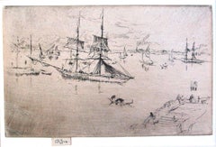
Lagoon: Noon
By James Abbott McNeill Whistler
Located in New York, NY
James McNeill Whistler (1830-1903), Lagoon: Noon, etching and drypoint, 1879-1880, signed with the butterfly and inscribed “imp” on the tab [also signed with the butterfly in the plate lower left]. Reference: Glasgow 209, third state (of 3), Kennedy 216, third state (of 3); Lochnan 231, 4 7/8 x 7 7/8 inches.
A fine impression with very little plate tone, and printed with extraordinary attention to the etching and drypoint details. The printed butterfly, usually only barely visible, is clearly defined in this impression (see detail below). Kennedy mades special note that an impression like this, with the clearly visible butterfly, was in the collection of John H. Wrenn.
On a commission from the Fine Arts Society, Whistler created the plates of his Venice series...
Category
1870s Impressionist Landscape Prints
Materials
Drypoint, Etching
Hill River
By Wayne Thiebaud
Located in Palo Alto, CA
Created in 2002, this Wayne Thiebaud Hill River, 2002 drypoint and aquatint in color on wove paper is hand signed by Wayne Thiebaud (Mesa, 1920 - Sacramento, 2021) in pencil in the l...
Category
Early 2000s Modern Landscape Prints
Materials
Drypoint, Aquatint
Dark Hill River
By Wayne Thiebaud
Located in Palo Alto, CA
The Sacramento River deltas and levees near Thiebaud’s studio became a source of inspiration starting in the mid-1990s where he would sketch en plein air and then work combined ideas...
Category
Early 2000s Modern Landscape Prints
Materials
Engraving, Drypoint, Aquatint
UNE JETEE EN ANGLETERRE
By Félix Hilaire Buhot
Located in Portland, ME
Buhot, Felix (French, 1847-1898). UNE JETEE EN ANGLETERRE. B & G 132, State two of eight. Etching with drypoint, aquatint and roulette, 1879. Signed in pencil, and with the red owl...
Category
1870s Landscape Prints
Materials
Drypoint, Etching, Aquatint
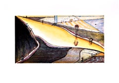
Crossings
By Frederick Mershimer
Located in New York, NY
CROSSINGS
Contemporary artist Frederick Mershimer created the mezzotint engraving entitled "Crossings" in 1998. This impression is signed, titled, and dated in pencil. The printed ...
Category
Late 20th Century American Realist Landscape Prints
Materials
Mezzotint
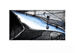
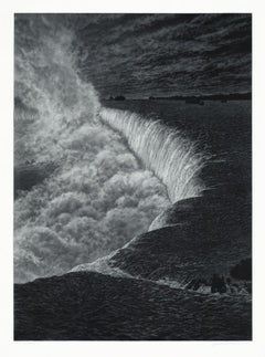
Niagara
By Frederick Mershimer
Located in New York, NY
NIAGARA
Contemporary artist Frederick Mershimer created the mezzotint engraving entitled “Niagara” in 2021. This impression is signed, titled, dated, and inscribed “5/45”- the 5th ...
Category
21st Century and Contemporary American Realist Landscape Prints
Materials
Mezzotint
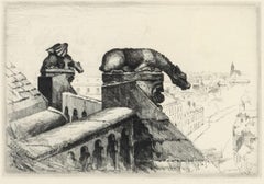
Guardians of the Spire; Amiens Cathedral Number 2
By John Taylor Arms
Located in Middletown, NY
Guardians of the Spire; Amiens Cathedral Number 2
New York: 1937. Etching and drypoint on watermarked F.J. Head cream-colored, antique laid paper, 6 3/4 ...
Category
Mid-20th Century American Modern Figurative Prints
Materials
Drypoint, Etching
More From This Seller
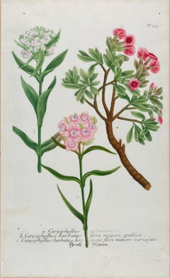
View AllFlowering Sweet William Plant: 18th C. Hand-colored Weinmann Botanical Engraving
By Johann Wilhelm Weinmann
Located in Alamo, CA
This hand-colored botanical mezzotint and line engraving by Johann Wilhelm Weinmann (1683-1741) is entitled "a. Caryophyllus Arborescens, b. Caryophyllus Barbatus". It is plate 327 i...
Category
Mid-18th Century Naturalistic Still-life Prints
Materials
Engraving, Mezzotint
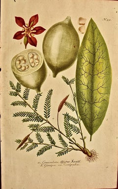
Genip Tree & Fruit: An 18th C. Hand-colored Botanical Engraving by J. Weinmann
By Johann Wilhelm Weinmann
Located in Alamo, CA
This hand-colored botanical mezzotint and line engraving by Johann Wilhelm Weinmann (1683-1741) is entitled "A. Geniculata Wieder Kraief, B. Genipa seu Ganipaba". It is plate 531 in...
Category
Mid-18th Century Naturalistic Still-life Prints
Materials
Engraving, Mezzotint
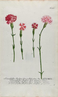
Flowering Carnation Plant: 18th C. Hand-colored Botanical Engraving by Weinmann
By Johann Wilhelm Weinmann
Located in Alamo, CA
This hand-colored botanical mezzotint and line engraving by Johann Wilhelm Weinmann (1683-1741) is entitled "Caryophyllus Anglicus flore". It is plate 326 in Weinmann's monumental pu...
Category
Mid-18th Century Naturalistic Still-life Prints
Materials
Engraving, Mezzotint
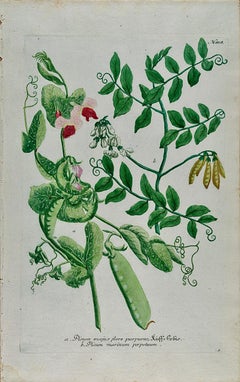
Flowering Garden Pea Plant: 18th C. Hand-colored Botanical Engraving by Weinmann
By Johann Wilhelm Weinmann
Located in Alamo, CA
This hand-colored botanical mezzotint and line engraving by Johann Wilhelm Weinmann (1683-1741) is entitled "Pisum Mapis flore pupureo". It is plate 818 in Weinmann's monumental publ...
Category
Mid-18th Century Naturalistic Still-life Prints
Materials
Engraving, Mezzotint
Fever Nut Plant "Ban Caretti": A 17th Century Engraving by Hendrik van Rheede
Located in Alamo, CA
This is a 17th century engraving of a fever or bonduc nut plant entitled "Ban Caretti" by Hendrik van Rheede tot Drakenstein, plate 20 from his 'Hortus Indi...
Category
Late 17th Century Naturalistic Landscape Prints
Materials
Engraving
View of Seravalle, Italy: A 16th Century Hand-colored Map by Braun & Hogenberg
By Franz Hogenberg
Located in Alamo, CA
This is an original 16th century copperplate originally hand-colored engraved map of View of Seravalle, Italy entitled "Seravallum Celeberrimum Marchiae Tarvisiniae in Agro Foro Juliensi Opp. - Seravalli, quam vides, Spectator, iconem, operi huic nostro suis sumptib. . . ." by Georg Braun & Franz Hogenberg, from their famous city atlas "Civitates Orbis Terrarum", published in Augsberg, Germany in 1575.
The map depicts a view of Seravalle, now Vittorio Veneto, in San Marino, Italy, north of Venice, in a topographically accurate bird's-eye view from the south. A water-filled moat is seen to the south of the city walls and farmland to the east. Two men are depicted standing on a hill in the lower right in conversation next to grain sacks and a grazing horse, while a younger man behind them to the right herds a mule carrying presumably pigs. A very colorful and ornate title cartouche is in the upper center and coat-of-arms are in the right and left upper corners. Serravalle lies in an idyllic setting in the foothills and surrounded by orchards. St Mary's Cathedral with its tall bell tower is prominent in the center of the town. The marketplace and town hall with a bell tower in the square are depicted. Houses and shops are around the main square. Serravalle's importance as an agricultural centre is emphasized by the figures in the foreground. In 1337 Serravalle was conquered by the Republic of Venice. In 1866 the town was united with neighbouring Ceneda to form the town of Vittorio Veneto.
The following is an English translation of an excerpt from the French description of the city on the back of the map: "Serravalle, a market town renowned for cloth, wine and grain, is in such a beautiful situation that the number of its inhabitants, attracted by the loveliness of the place, has grown so much at times that the wall encircling it has had to be enlarged for the third time. The city with the surrounding town once belonged to the Church in Ceneda as an imperial fief. It subsequently became the seat of the Da Camino family (a princely house that at that time was one of the five most noble in all Italy). Now the city is under the sway of the Venetians but is prudently governed by them. For they send only one city councillor with instructions to ensure that justice prevails and to collect duties. In all else, power lies in the hands of the noble families."
This is a translation of the Latin in the title cartouche on the front: "The picture of the town of Serravalle, which you see, viewer, has been contributed to our work entirely at his own expense by Minutius, son of Hieronymus Minutius, a noble gentleman and one renowned for the far-reaching competence of his jurisdiction. We saw him sojourning in Cologne, where he was on business for Gregory XIII; while our good wishes accompany him, we should also like to accompany him on his way with this remembrance, even though it might be against his will, so that even those who have not seen him may learn of his excellence. However, those who do not yet know him will also see his excellence if God the Almighthy does not summon erring souls too soon back to the eternal seat of the Blessed."
References: Van der Krogt 4, 4728, State 1; Taschen, Braun and Hogenberg, p.331; Fauser, #14960
This striking hand-colored city view is printed on laid, chain-linked paper with wide margins. The sheet measures 16" high by 21" wide. There is a central vertical fold as issued and French text on the verso, with Latin on the front. There is some discoloration in the upper and right margins which may represent some watercolor paint from the time of the original hand-coloring of the map. There is a small hole to the right of the upper portion of the vertical fold, which is only visible when held up to light and an area of reinforcement on the verso of the lower vertical fold. The map is otherwise in very good to excellent condition.
Braun and Hogenberg's 'The Civitates Orbis Terrarum' was the second atlas of maps ever published and the first atlas of cities and towns of the world. It is one of the most important books published in the 16th century. Most of the maps in the atlas were engraved by Franz Hogenberg and the text, with its descriptions of the history and additional factual information of the cities, was written by a team of writers and edited by Georg Braun. The work contained 546 bird-eye views and map views of cities and towns from all over the world. It gave graphic representation of the main features of the illustrated cities and towns, including the buildings and streets. Although the ordinary buildings are stylized, the principal buildings are reproduced from actual drawings created on location. The principal landmarks and streets can still be recognized today. In addition, the maps often include the heraldic arms of the city, the nature of the surrounding countryside, the important rivers, streams and harbors, even depicting stone bridges, wooden pontoons, flat-bottomed ferries, ships and working boats, wharves and jetties, as well as land-based activities, including horsemen, pedestrians, wagons, coaches, and palanquins. Small vignettes are often included which illustrate the trade, occupations and habits of the local inhabitants, such as agriculture, paper-making and textiles, as well as local forms of punishment, such as gibbets, wheels, floggings etc. Large figures dressed in their local costume are often presented out of proportion in the foreground. The aim of the authors was to give as much information as possible in a pleasing visual form. They succeeded in creating maps that were both informative and decorative works of art. The atlas is a wonderful glimpse of life in medieval Europe.
Georg Braun (1541-1622) was German Catholic...
Category
16th Century Old Masters Landscape Prints
Materials
Engraving
