Items Similar to Four Koa Wood Framed 18th C. Engravings from Captain Cook's 3rd Voyage Journal

Want more images or videos?
Request additional images or videos from the seller
1 of 24
John WebberFour Koa Wood Framed 18th C. Engravings from Captain Cook's 3rd Voyage Journal1784
1784
$9,575
£7,298.99
€8,338.53
CA$13,473.38
A$14,757.52
CHF 7,769.84
MX$176,126.13
NOK 99,019.61
SEK 90,518.85
DKK 62,311.25
About the Item
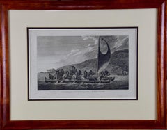
A grouping of four framed engravings of Hawaii, Tahiti, Tonga and Vancouver Island from the atlas of the official British Admiralty sanctioned journal of Captain Cook's 3rd Voyage entitled "A Voyage to the Pacific Ocean Undertaken by the Command of His Majesty, for Making Discoveries in the Northern Hemisphere", published upon completion of the voyage in London in 1784 by Strahan & Cadell. These engravings were made from drawings by John Webber (1752-1793), who was the artist on Captain James Cook's 3rd and final voyage of discovery. The set of engravings includes: "A Canoe of the Sandwich Islands, the Rowers Masked", Plate 65 in the atlas; "A Dance in Otaheite" (Tahiti), Plate 28; "King of the Friendly Islands" (Tonga), plate 20; "Inside of a House in Nootka Sound" (Canada), plate 42.
These engravings are professionally framed in Koa wood, the same wood as was used to make the canoes of the ancient Hawaiians. Koa wood is legendary in Hawaii. Not only is this amazing wood native to Hawaii, but it is known for the deep rich colors and varied grain pattern. Koa has an honored heritage in Hawaii and is highly revered and sacred. The word “koa” means “warrior” in Hawaiian. The warriors of King Kamehameha the Great, created canoes and weapons from a wood plentiful on the Big Island of Hawaii. This wood became synonymous with the warriors themselves, and it became known as koa.
These four engravings would make a wonderful grouping for a display of 2, 3 or 4 prints. They may be purchased separately or in groups on 1stDibs. Their listing Reference #'s are: LU117324682432, LU117324682022, LU117324684052 and LU117324684062. A discount is available for a grouping depending on the number of items included.
Hawaii was discovered by Captain Cook (1728-1779) during this voyage. Hawaii was originally called The Sandwich Islands in honor of The Earl of Sandwich who, as head of the British Admiralty, authorized the funds necessary to finance the voyage. Captain Cook was killed by natives in Kealakekua Bay on the big island of Hawaii in 1779. His ships the Resolution and Discovery then returned to England. Other notables who were part of this expedition included Captain William Bligh, Cook's sailing master, who would later go down in history as captain of the mutinous crew of the Bounty and George Vancouver who would later explore and chart North America's northwestern Pacific Coast regions, including the coasts of Alaska, Washington, and Oregon, as well as the province of British Columbia in Canada. Vancouver Island and the city of Vancouver, British Columbia are named for him, as is Vancouver, Washington.
The prints are in excellent condition.
- Creator:John Webber (1751 - 1793, British)
- Creation Year:1784
- Dimensions:Height: 20.75 in (52.71 cm)Width: 26.75 in (67.95 cm)Depth: 0.88 in (2.24 cm)
- Medium:
- Period:1780-1789
- Condition:Scattered mild foxing.
- Gallery Location:Alamo, CA
- Reference Number:Seller: #'s: 3853, 3854, 3855 and 38561stDibs: LU117325486982
John Webber
John Webber (1751-1793) was recommended to the Admiralty for appointment as artist for the Captain Cook's 3rd voyage by the Swedish botanist Daniel Carlsson Solander (1733-1782) who had accompanied Cook on his first voyage. Just 24 years old when he joined the Captain Cook’s ship the Resolution at Plymouth one week prior to departure, Webber's skill in both portraiture and landscape resulted in a visual record of Cook's third voyage that is unsurpassed in the annals of 18th century exploration.
About the Seller
5.0
Platinum Seller
Premium sellers with a 4.7+ rating and 24-hour response times
Established in 2011
1stDibs seller since 2019
299 sales on 1stDibs
Typical response time: 1 hour
- ShippingRetrieving quote...Shipping from: Alamo, CA
- Return Policy
More From This Seller
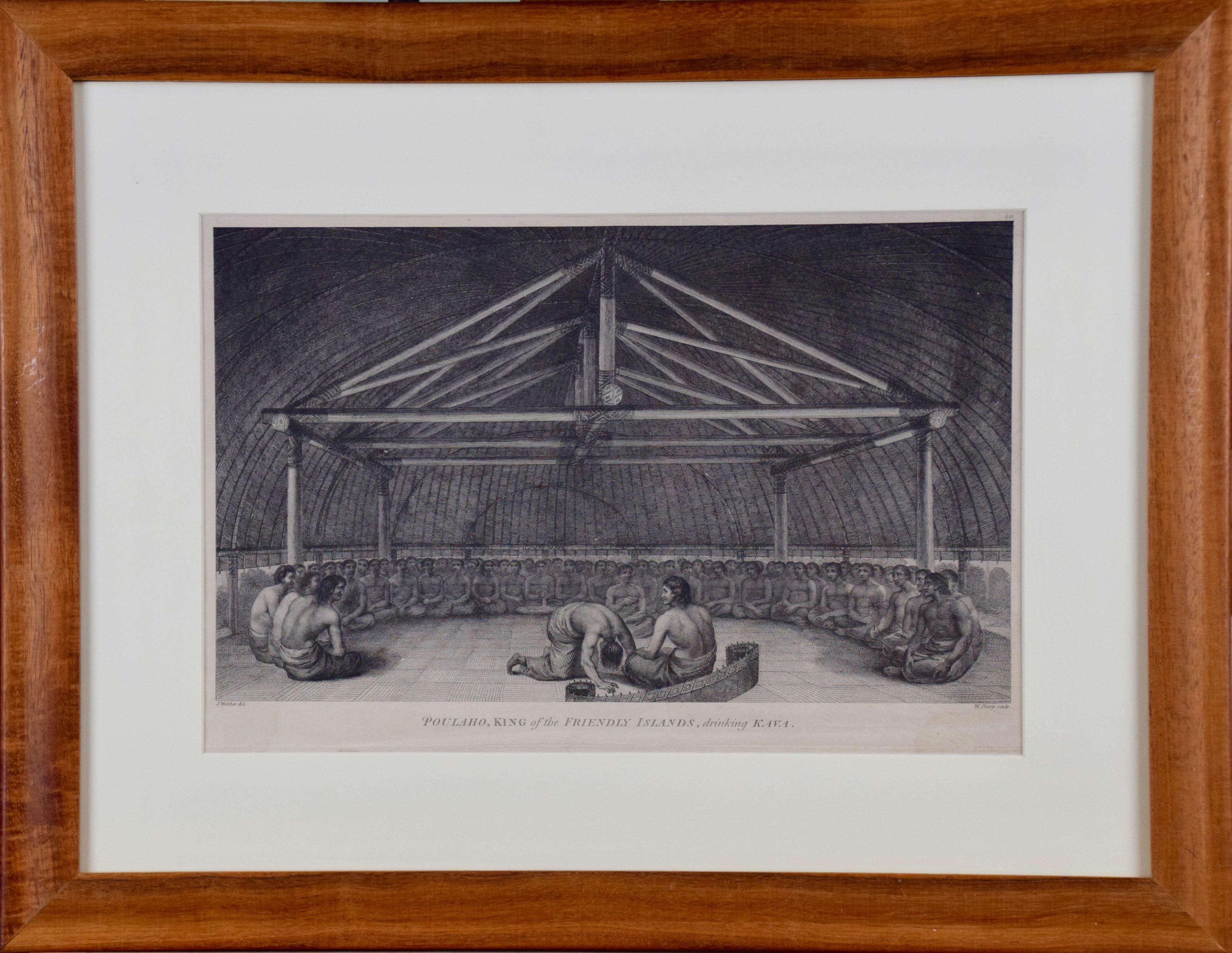
View All"King of the Friendly Islands" (Tonga); Engraving from Captain Cook's 3rd Voyage
By John Webber
Located in Alamo, CA
"Poulaho, King of the Friendly Islands, Drinking Kava" is an engraving created by William Sharp (1749-1824), from a drawing by John Webber (1752-1793), who was the artist on Captain James Cook's 3rd and final voyage of discovery. It was published in the atlas of "A Voyage to the Pacific Ocean Undertaken by the Command of His Majesty, for Making Discoveries in the Northern Hemisphere", the official British Admirality sanctioned journal published upon completion of the voyage in London in 1784 by Strahan & Cadell.
Captain Cook visited Tonga on his 3rd voyage, which he named The Friendly Islands because of the warm welcome he and his crew received, unlike some of the other more hostile Pacific islands. The engraving depicts Cook and his men observed a kava ceremony at the village of Mu’a on Tongatapu. King Paulaho sits in the centre foreground, his back to the spectator with a man kneeling before him. The ceremonial mat depicted behind Paulaho indicates that nobody was allowed to sit behind him. The figure in the centre holds a single cup, referring to the Tongan custom of offering the cup to the king first. Kava is native to the islands of the South Pacific and was first described for English readers in 1768 by Captain James Cook. The kava root has been used for centuries as a central feature of ceremonies and celebrations because it was able to bring about a calming and pleasant social atmosphere. The root was crushed and processed into coconut milk to become the focal ceremonial beverage, simply referred to as kava.
This engraving is presented in a Koa wood frame and a white mat. Koa wood is legendary in Hawaii. There are occasional faint spots, but the print is otherwise in very good condition. This amazing Koa wood is native to Hawaii and it is known for the deep rich colors and varied grain pattern. Koa has an honored heritage in Hawaii and is highly revered and sacred. The word “koa” means “warrior” in Hawaiian. The warriors of King Kamehameha the Great, created canoes and weapons from a wood plentiful on the Big Island of Hawaii. This wood became synonymous with the warriors themselves, and it became known as koa.
There are three other engravings listed from the official journal of Captain Cook's 3rd voyage available that are presented in identical Koa wood frames and mats (LU117324682422, LU117324684052, LU117324684032). They would make a wonderful grouping for a display of 2, 3 or 4 prints. A discount is available for a grouping depending on the number of items included.
Captain Cook is remembered as one of the greatest explorers and navigators in history. His explorations included Australia, New Zealand and islands of the South Pacific and the northwest coast of North America. Hawaii was discovered by Captain Cook during this voyage. Hawaii was originally called The Sandwich Islands in honor of The Earl of Sandwich...
Category
1780s Realist Figurative Prints
Materials
Engraving
Sandwich Islands Canoe (Hawaii): Framed 18th C. Engraving Captain Cook's Journal
By John Webber
Located in Alamo, CA
"A Canoe of the Sandwich Islands, the Rowers Masked" is an engraving created by Charles Grignion, from a drawing by John Webber (1752-1793), who was the artist on Captain James Cook's 3rd and final voyage of discovery. It is Plate 65 in the atlas of "A Voyage to the Pacific Ocean Undertaken by the Command of His Majesty, for Making Discoveries in the Northern Hemisphere", the official British Admiralty sanctioned journal published upon completion of the voyage in London in 1784 by Strahan & Cadell.
This famous image of ten Hawaiian rowers transporting a priest who is carrying a feather-covered image of Kukailimoku, the Hawaiian god of war. The priests and paddlers are all wearing gourd masks in their double-hulled canoe with an upright lateen woven sail. Each hull was shaped from a single large Koa log harvested from island rainforests, where they were carved before being transported to the coast.
This engraving is presented in a Koa wood frame and a white mat. There are occasional faint spots, but the print is otherwise in very good condition. Koa is the same wood as was used to make the canoe. Koa wood is legendary in Hawaii. Not only is this amazing wood native to Hawaii, but it is known for the deep rich colors and varied grain pattern. Koa has an honored heritage in Hawaii and is highly revered and sacred. The word “koa” means “warrior” in Hawaiian. The warriors of King Kamehameha the Great, created canoes and weapons from a wood plentiful on the Big Island of Hawaii. This wood became synonymous with the warriors themselves, and it became known as koa. The frame measures 20.75" high, 26.75" wide and 0.88" deep.
There are three other engravings listed from the official journal of Captain Cook's 3rd voyage available that are presented in identical Koa wood frames and mat (LU117324682022, LU117324684052, LU117324684062). They would make a wonderful grouping for a display of 2, 3 or 4 prints. A discount is available for a grouping depending on the number of items included.
Hawaii was discovered by Captain Cook (1728-1779) during this voyage. Hawaii was originally called The Sandwich Islands in honor of The Earl of Sandwich...
Category
1780s Landscape Prints
Materials
Engraving
Kamtschatka, Russia: Engraving by J. Webber from Capt. Cook's 3rd Voyage Journal
By John Webber
Located in Alamo, CA
"A View of the Town and Harbour of St Peter and St Paul, in Kamtschatka" is an engraving created by Charles Grignion, from a drawing by John Webber (1752-1793), who was the artist on...
Category
1780s Landscape Prints
Materials
Engraving
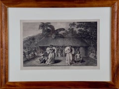
"A Dance in Otaheite" (Tahiti), Engraving from Captain Cook's 3rd Voyage
By John Webber
Located in Alamo, CA
"A Dance in Otaheite" (Tahiti) is an engraving created by William Sharp (1749-1824), from a drawing by John Webber (1752-1793), who was the artist on Captain James Cook's 3rd and final voyage of discovery. It is a plate in the atlas of "A Voyage to the Pacific Ocean Undertaken by the Command of His Majesty, for Making Discoveries in the Northern Hemisphere", the official British Admirality sanctioned journal published upon completion of the voyage in London in 1784 by Strahan & Cadell.
Two women and two men wearing ceremonial costumes, performing a dance outdoors standing on a mat. Three men are playing the drums in the background, in front of a thatched roof building. An audience of men are sitting on both sides of the stage. By the time Webber arrived in Tahiti, 'south sea' imagery had become familiar. Webber gave concentrated attention to dance. He had the opportunity to distinguish the Tahitian dance from the more formalized dancing of Tonga. Whereas they seem to have called to mind the more formal dances of antiquity, the Tahitian dancing aroused memories of peasant and folk dancing.
This engraving is professionally framed in Koa wood. Koa wood is legendary in Hawaii. Not only is this amazing wood native to Hawaii, but it is known for the deep rich colors and varied grain pattern. Koa has an honored heritage in Hawaii and is highly revered and sacred. The word “koa” means “warrior” in Hawaiian. The warriors of King Kamehameha the Great, created canoes and weapons from a wood plentiful on the Big Island of Hawaii. This wood became synonymous with the warriors themselves, and it became known as koa.
The print is in excellent condition.
There are three other engravings listed from the official journal of Captain Cook's 3rd voyage available that are presented in identical Koa wood frames and double mats (LU117324682432, LU117324684052, LU117324684062). They would make a wonderful grouping for a display of 2, 3 or 4 prints. A discount is available for a grouping depending on the number of items included.
Hawaii was discovered by Captain Cook during this voyage. Hawaii was originally called The Sandwich Islands in honor of The Earl of Sandwich...
Category
1780s Realist Landscape Prints
Materials
Engraving
Reception for Captain Cook, Tonga: Original 18th C. Engraving, Cook's 3rd Voyage
By John Webber
Located in Alamo, CA
"The Reception of Capt. Cook in Hapaee" is an original 18th century engraving from a drawing by John Webber (1751-1793), who was the artist who accompanied Captain Cook on his third ...
Category
1780s Landscape Prints
Materials
Engraving

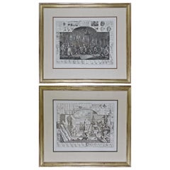
William Hogarth's "Analysis of Beauty": A Set of Two Framed 18th C. Engravings
By William Hogarth
Located in Alamo, CA
The two plates in this set were created utilizing both engraving and etching techniques by William Hogarth in 1753, originally as illustrations of his book on aesthetics, entitled "Analysis of Beauty". Due to their popularity, these plates were later published separately. The publication line in the lower right reads: "Designed, Engraved, and Publish'd by Wm. Hogarth, March 5th 1753, according to Act of Parliament." Hogarth's original copper plates were refurbished where needed by James Heath and engravings were republished in London in 1822 by Braddock, Cradock & Joy. This was the last time Hogarth's copper plates were used for printing. Most were melted during World War I for the construction of bombs.
These large folio sized "Analysis of Beauty" engravings are presented in antiqued gold-colored frames with double mats; the outer silk mats are light brown-colored and the inner mats are dark brown. Each frame measures 27.38" x 31.25" x 1.13". There is one tiny spot in the right margin of plate 1 and another in the lower margin; the latter could be from the printing process. The prints are otherwise in excellent condition.
The "Analysis of Beauty" series is in the collection of many major museums, including: The British Museum, The Metropolitan Museum of Art, The Tate Museum, The Chicago Art Institute and The Fine Arts Museums of San Francisco.
The first engraving (Plate 1) depicts a courtyard of statues which is filled with some of the most famous works of classical sculpture. The most important sculptures are surrounded by less impressive works. The Medicean Venus (#13) is in the center with a statue of Julius Caesar (#19) to the right, elevated on a pulley with a short, overdressed Brutus stands over the falling Caesar. The Apollo Belvedere (#12) is next. A judge stands to the right with his foot on a cherub (#16). Another crying cherub holds a gallows and wipes his tears with the judge's robe.
A sphinx (#21) and the drunken Silenus (#107) are below the Venus. Michaelangelo's torso (#54) and a statue of Antonius (#6) are seen in the foreground. The Farnese Hercules (#3) and a bust of another Hercules (#4) under two statuettes of Isis are also included in the scene.
The key to these objects is included in the form of a serpentine line winding around a cone (#26), Hogarth's "Line of Beauty". For Hogarth the winding line is an essential element of beauty in art. Hogarth's theory of beauty is communicated in this plate.
Plate 2 is thought to represent the Wanstead Assembly, with the Earl of Tynley and his household. It is an adaptation of a scene in the Happy Marriage series, which complements Hogarth's Marriage à la Mode...
Category
Mid-18th Century Old Masters Interior Prints
Materials
Engraving, Etching
You May Also Like
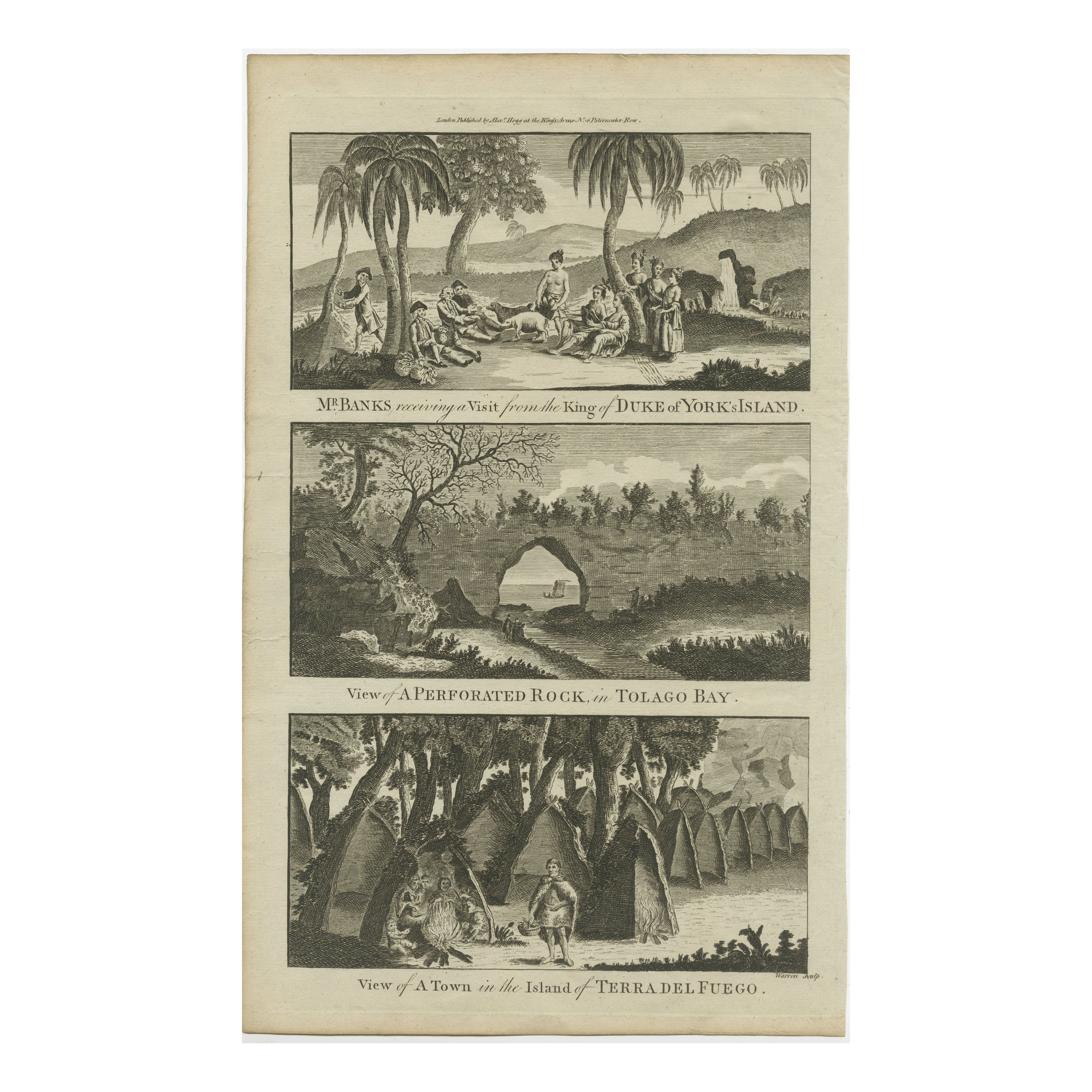
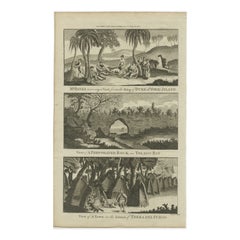
18th Century Engravings of Exploration: Banks, Tolago Bay, Terra del Fuego
Located in Langweer, NL
The sheet contains three separate engravings, each depicting a different scene:
1. Top Engraving: "Mr. Banks receiving a Visit from the King of Duke of York's Island"
- This eng...
Category
Antique 1790s Prints
Materials
Paper
$229 Sale Price
20% Off
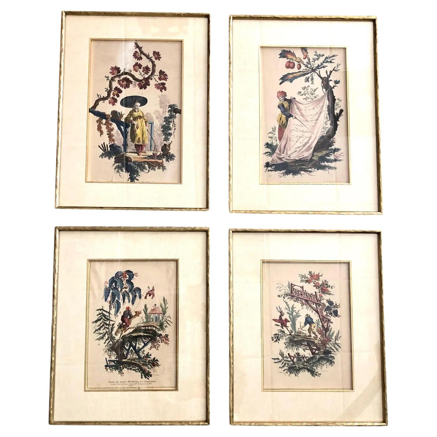
Early Engravings Dated 1759 - Set of 4
Located in Tampa, FL
18th century circa 1750s English chinoiserie figures in the french taste. Drawn, designed and hand colored by Jean Pillement and engraved by P. C.Canot. In Italian gilded bamboo styl...
Category
Antique 1750s English Drawings
Materials
Paper

$2,125 / set
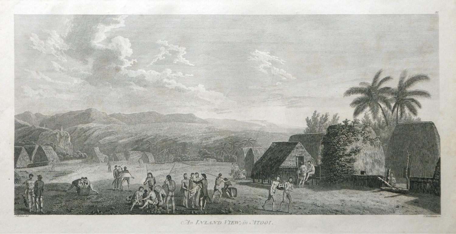
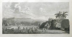
An Inland View; in Atooi ( Hawaii ) 1784 Captain Cook engraving by John Webber
By John Webber
Located in Paonia, CO
An Inland View in Atooi ( Hawaii ) is from the 1784 First Edition Atlas Accompanying Capt. James Cook and King; Third and Final Voyage of Captain James Cook. This engraving depicts ...
Category
1780s Realist Landscape Prints
Materials
Engraving
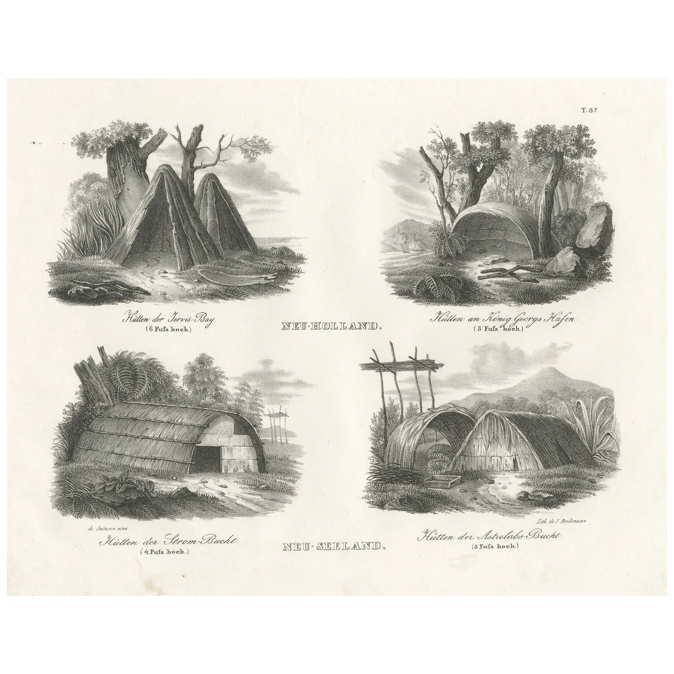
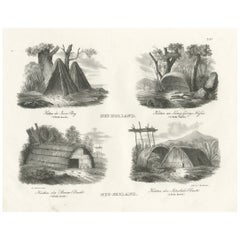
Indigenous Dwellings from New Holland and New Zealand Engraved in 1836
Located in Langweer, NL
Title: Indigenous Dwellings from New Holland and New Zealand
Description: This engraving presents a fascinating comparative study of indigenous dwellings from two regions: New Hol...
Category
Antique 1830s Swiss Prints
Materials
Paper
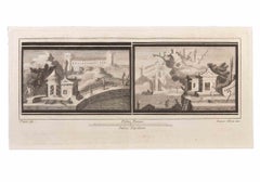
Seascapes with Monuments and Figures - Etching by Luigi Aloja - 18th Century
Located in Roma, IT
Seascapes With Monuments and Figures is an Etching realized by Luigi Aloja (1783-1837).
The etching belongs to the print suite “Antiquities of Herculaneum Exposed” (original title:...
Category
Late 18th Century Old Masters Figurative Prints
Materials
Etching
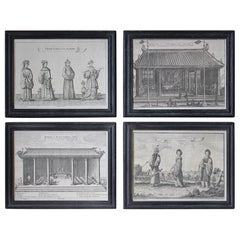
18th Century Ethnographic Interest Asian Natives & Temples Framed Engravings
Located in Lowestoft, GB
A collection of four late 18th century engravings of local tribes and temples from the Asian continent, printed by Nathaniel Parr and James Basire.
Later housed in 19th century ebon...
Category
Antique Late 18th Century English Prints
Materials
Glass, Pine, Paper