Items Similar to A Night Dance by Women in Tonga: Original 18th C. Engraving, Cook's 3rd Voyage

Want more images or videos?
Request additional images or videos from the seller
1 of 6
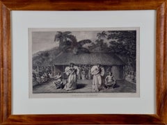
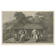
John WebberA Night Dance by Women in Tonga: Original 18th C. Engraving, Cook's 3rd Voyage1785
1785
$275
£213.23
€241.83
CA$394.20
A$428.70
CHF 225.85
MX$5,206.67
NOK 2,839.39
SEK 2,661.70
DKK 1,815.59
About the Item
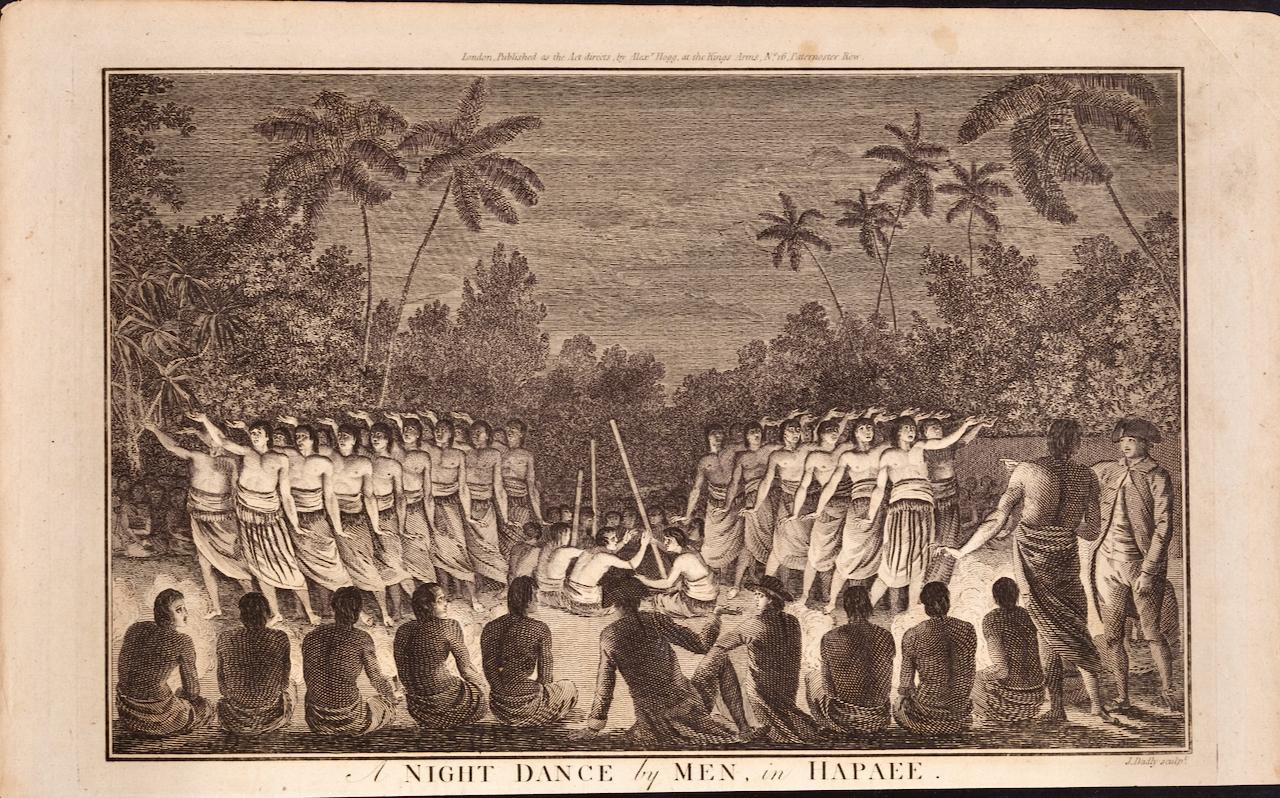
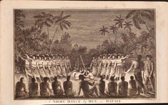
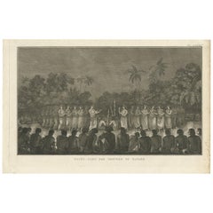
"A Night Dance by Women in Hapaee" is an original 18th century engraving from a drawing by John Webber (1751-1793), who was the artist who accompanied Captain Cook on his third voyage of discovery, 1776-1780. The engraving appeared in Alexander Hogg's publication "A New, Authentic, and Complete Collection of Voyages Round the World" published in London in 1785.
This engraving depicts an outdoor ceremony in Tonga to honor the visit by Captain Cook from May 1st to 14th, 1777. There is a lush landscape in the background. Bare-chested women are dancing to the music created by men with long sticks. The artist has created a beautiful lighting illuminating the dancers while the backs of the audience in the foreground are a dark contrast. Captain Cook sits in the foreground flanked by Tongan men and two of his officers. A beautiful lush landscape including palm trees is in the background. The ceremony was witnessed by John Webber, the artist who accompanied Cook on his 3rd voyage of discovery. He made the drawing that was used for this 18th century engraving.
This engraving depicts an outdoor ceremony in Tonga to honor the visit by Captain Cook from May 1st to 14th, 1777. A dance performance by bare-chested women is taking place to welcome Cook and his men to Hapaee, an island in Tonga, which Cook called the Friendly Islands because of his unusually warm welcome. The dance on this island was usually performed in a remote location and lit with torchlight. The me’elaufola, as it was called, was thought to harness sacred powers from Pulotu, the afterworld. The rhythm of the dancers’ feet, extended arm movements, and thuds of bamboo canes escalated to a frenzied crescendo of noise, prompting ecstatic revelations and visions of the spiritual world. In Webber’s engraving the dancers’ bodies are lit from below, shrouding the scene with an atmosphere of anticipation and mysticism. Captain Cook is shown is shown in the foreground from behind him as he and some of his officers watch the dance. Captain Cook described the event in his words in his journal: ”Each of them with an instrument shaped somewhat like a paddle, 2 1/2 feet in length, with a small handle, and a thin blade so that they were very light. With these instruments they made many and various flourishes, each of which was accompanied with a different attitude of the body or a different movement. The musical instruments consisted of 2 drums, or rather two hollow logs of wood, from which some varied notes were produced, by beating on them with two sticks. It did not appear that the dancers were much assisted or directed by these sounds, but by a chorus of vocal music, in which all the performers joined at the same time. Their song was not destitute of pleasing melody; and all their corresponding motions were executed with so much skill, that the numerous body of dancers seemed to act, as if they were one great machine.” The artist has captured the beautiful lighting illuminating the dancers while the backs of the audience in the foreground are a dark contrast. Captain Cook is reportedly seated in the foreground between a Tongan man and two of his officers. There is a lush landscape in the background, including palm trees. The ceremony was witnessed by John Webber, the artist who accompanied Cook on his 3rd voyage of discovery. He made the drawing that was used for this 18th century engraving.
The engraving is printed on laid chain-linked paper. The sheet measures 9.63" in height on the left and 15.25" in width. The upper left and lower right corners are missing and there are spots and smudges in the upper margins and to a lesser extent in the upper right margin and a small chip in the lower edge. Most of these issues would be obscured by a frame mat. The image is in excellent condition; beautifully inked.
"A Night Dance by Women in Hapaee" would mkae a striking display grouping if paired with "A Night Dance by Men in Hapaee", which is also available on this site.
Alexander Hogg was an 18th and early 19th century publisher of illustrated books of architectural and historical prints, as well as maps. His publishing house was located in London at the Kings Arms on Paternoster Row.
- Creator:John Webber (1751 - 1793, British)
- Creation Year:1785
- Dimensions:Height: 9.63 in (24.47 cm)Width: 15.25 in (38.74 cm)
- Medium:
- Period:1780-1789
- Framing:Framing Options Available
- Condition:
- Gallery Location:Alamo, CA
- Reference Number:Seller: # 10221stDibs: LU1173216422352
John Webber
John Webber (1751-1793) was recommended to the Admiralty for appointment as artist for the Captain Cook's 3rd voyage by the Swedish botanist Daniel Carlsson Solander (1733-1782) who had accompanied Cook on his first voyage. Just 24 years old when he joined the Captain Cook’s ship the Resolution at Plymouth one week prior to departure, Webber's skill in both portraiture and landscape resulted in a visual record of Cook's third voyage that is unsurpassed in the annals of 18th century exploration.
About the Seller
5.0
Platinum Seller
Premium sellers with a 4.7+ rating and 24-hour response times
Established in 2011
1stDibs seller since 2019
293 sales on 1stDibs
Typical response time: 1 hour
- ShippingRetrieving quote...Shipping from: Alamo, CA
- Return Policy
Authenticity Guarantee
In the unlikely event there’s an issue with an item’s authenticity, contact us within 1 year for a full refund. DetailsMoney-Back Guarantee
If your item is not as described, is damaged in transit, or does not arrive, contact us within 7 days for a full refund. Details24-Hour Cancellation
You have a 24-hour grace period in which to reconsider your purchase, with no questions asked.Vetted Professional Sellers
Our world-class sellers must adhere to strict standards for service and quality, maintaining the integrity of our listings.Price-Match Guarantee
If you find that a seller listed the same item for a lower price elsewhere, we’ll match it.Trusted Global Delivery
Our best-in-class carrier network provides specialized shipping options worldwide, including custom delivery.More From This Seller
View AllA Night Dance by Men in Tonga: An Original 18th C. Engraving, Cook's 3rd Voyage
By John Webber
Located in Alamo, CA
"A Night Dance by Men in Hapaee" is an original 18th century engraving from a drawing by John Webber (1751-1793), who was the artist who accompanied Captain Cook on his third voyage ...
Category
1780s Landscape Prints
Materials
Engraving
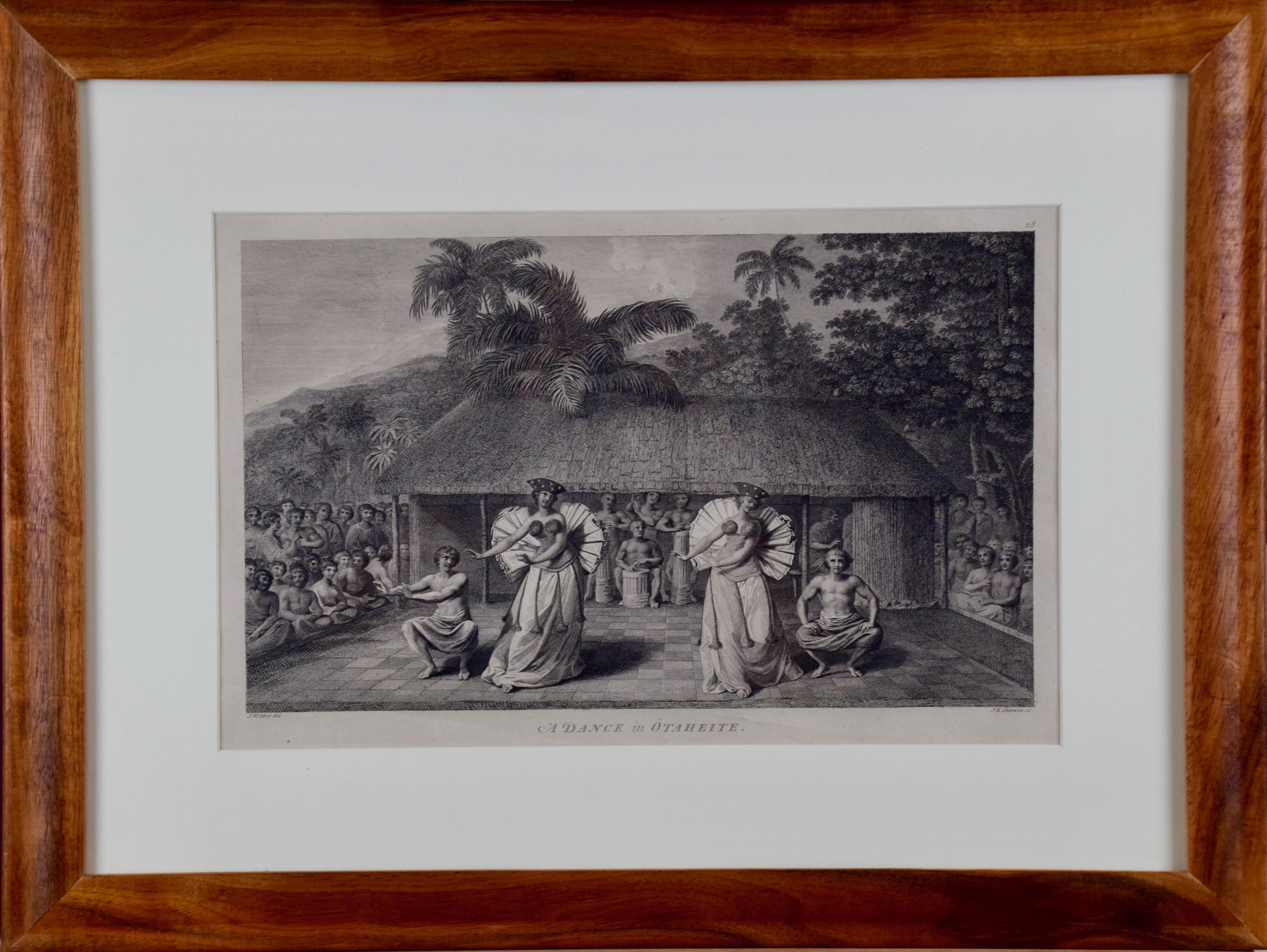
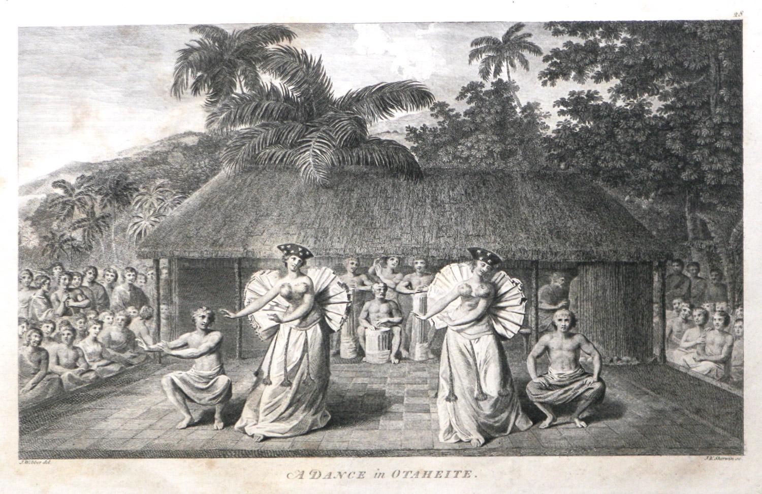
"A Dance in Otaheite" (Tahiti), Engraving from Captain Cook's 3rd Voyage
By John Webber
Located in Alamo, CA
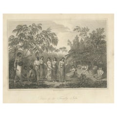
"A Dance in Otaheite" (Tahiti) is an engraving created by William Sharp (1749-1824), from a drawing by John Webber (1752-1793), who was the artist on Captain James Cook's 3rd and final voyage of discovery. It is a plate in the atlas of "A Voyage to the Pacific Ocean Undertaken by the Command of His Majesty, for Making Discoveries in the Northern Hemisphere", the official British Admirality sanctioned journal published upon completion of the voyage in London in 1784 by Strahan & Cadell.
Two women and two men wearing ceremonial costumes, performing a dance outdoors standing on a mat. Three men are playing the drums in the background, in front of a thatched roof building. An audience of men are sitting on both sides of the stage. By the time Webber arrived in Tahiti, 'south sea' imagery had become familiar. Webber gave concentrated attention to dance. He had the opportunity to distinguish the Tahitian dance from the more formalized dancing of Tonga. Whereas they seem to have called to mind the more formal dances of antiquity, the Tahitian dancing aroused memories of peasant and folk dancing.
This engraving is professionally framed in Koa wood. Koa wood is legendary in Hawaii. Not only is this amazing wood native to Hawaii, but it is known for the deep rich colors and varied grain pattern. Koa has an honored heritage in Hawaii and is highly revered and sacred. The word “koa” means “warrior” in Hawaiian. The warriors of King Kamehameha the Great, created canoes and weapons from a wood plentiful on the Big Island of Hawaii. This wood became synonymous with the warriors themselves, and it became known as koa.
The print is in excellent condition.
There are three other engravings listed from the official journal of Captain Cook's 3rd voyage available that are presented in identical Koa wood frames and double mats (LU117324682432, LU117324684052, LU117324684062). They would make a wonderful grouping for a display of 2, 3 or 4 prints. A discount is available for a grouping depending on the number of items included.
Hawaii was discovered by Captain Cook during this voyage. Hawaii was originally called The Sandwich Islands in honor of The Earl of Sandwich...
Category
1780s Realist Landscape Prints
Materials
Engraving
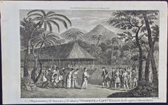
Reception for Captain Cook, Tonga: Original 18th C. Engraving, Cook's 3rd Voyage
By John Webber
Located in Alamo, CA
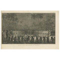
"The Reception of Capt. Cook in Hapaee" is an original 18th century engraving from a drawing by John Webber (1751-1793), who was the artist who accompanied Captain Cook on his third ...
Category
1780s Landscape Prints
Materials
Engraving

"King of the Friendly Islands" (Tonga); Engraving from Captain Cook's 3rd Voyage
By John Webber
Located in Alamo, CA
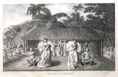
"Poulaho, King of the Friendly Islands, Drinking Kava" is an engraving created by William Sharp (1749-1824), from a drawing by John Webber (1752-1793), who was the artist on Captain James Cook's 3rd and final voyage of discovery. It was published in the atlas of "A Voyage to the Pacific Ocean Undertaken by the Command of His Majesty, for Making Discoveries in the Northern Hemisphere", the official British Admirality sanctioned journal published upon completion of the voyage in London in 1784 by Strahan & Cadell.
Captain Cook visited Tonga on his 3rd voyage, which he named The Friendly Islands because of the warm welcome he and his crew received, unlike some of the other more hostile Pacific islands. The engraving depicts Cook and his men observed a kava ceremony at the village of Mu’a on Tongatapu. King Paulaho sits in the centre foreground, his back to the spectator with a man kneeling before him. The ceremonial mat depicted behind Paulaho indicates that nobody was allowed to sit behind him. The figure in the centre holds a single cup, referring to the Tongan custom of offering the cup to the king first. Kava is native to the islands of the South Pacific and was first described for English readers in 1768 by Captain James Cook. The kava root has been used for centuries as a central feature of ceremonies and celebrations because it was able to bring about a calming and pleasant social atmosphere. The root was crushed and processed into coconut milk to become the focal ceremonial beverage, simply referred to as kava.
This engraving is presented in a Koa wood frame and a white mat. Koa wood is legendary in Hawaii. There are occasional faint spots, but the print is otherwise in very good condition. This amazing Koa wood is native to Hawaii and it is known for the deep rich colors and varied grain pattern. Koa has an honored heritage in Hawaii and is highly revered and sacred. The word “koa” means “warrior” in Hawaiian. The warriors of King Kamehameha the Great, created canoes and weapons from a wood plentiful on the Big Island of Hawaii. This wood became synonymous with the warriors themselves, and it became known as koa.
There are three other engravings listed from the official journal of Captain Cook's 3rd voyage available that are presented in identical Koa wood frames and mats (LU117324682422, LU117324684052, LU117324684032). They would make a wonderful grouping for a display of 2, 3 or 4 prints. A discount is available for a grouping depending on the number of items included.
Captain Cook is remembered as one of the greatest explorers and navigators in history. His explorations included Australia, New Zealand and islands of the South Pacific and the northwest coast of North America. Hawaii was discovered by Captain Cook during this voyage. Hawaii was originally called The Sandwich Islands in honor of The Earl of Sandwich...
Category
1780s Realist Figurative Prints
Materials
Engraving
Surrender of Tahiti to Captain Wallis: An Original 18th C. Engraving
By John Webber
Located in Alamo, CA
"A Representation of the Surrender of the Island of Otaheite to Capt.n Wallis, by the Supposed Queen of Oberea" is an original 18th century engraving created by Sparrow, from a drawi...
Category
1780s Landscape Prints
Materials
Engraving
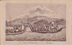
The Fleet of Tahiti displayed for Captain Cook: An Original 18th C. Engraving
By William Hodges
Located in Alamo, CA
"The Fleet of Otaheite, Assembled at Oparee" is an original 18th century engraving from a drawing by William Hodges (1744-1797), who was the artist who accompanies Captain Cook on hi...
Category
1780s Landscape Prints
Materials
Engraving
You May Also Like
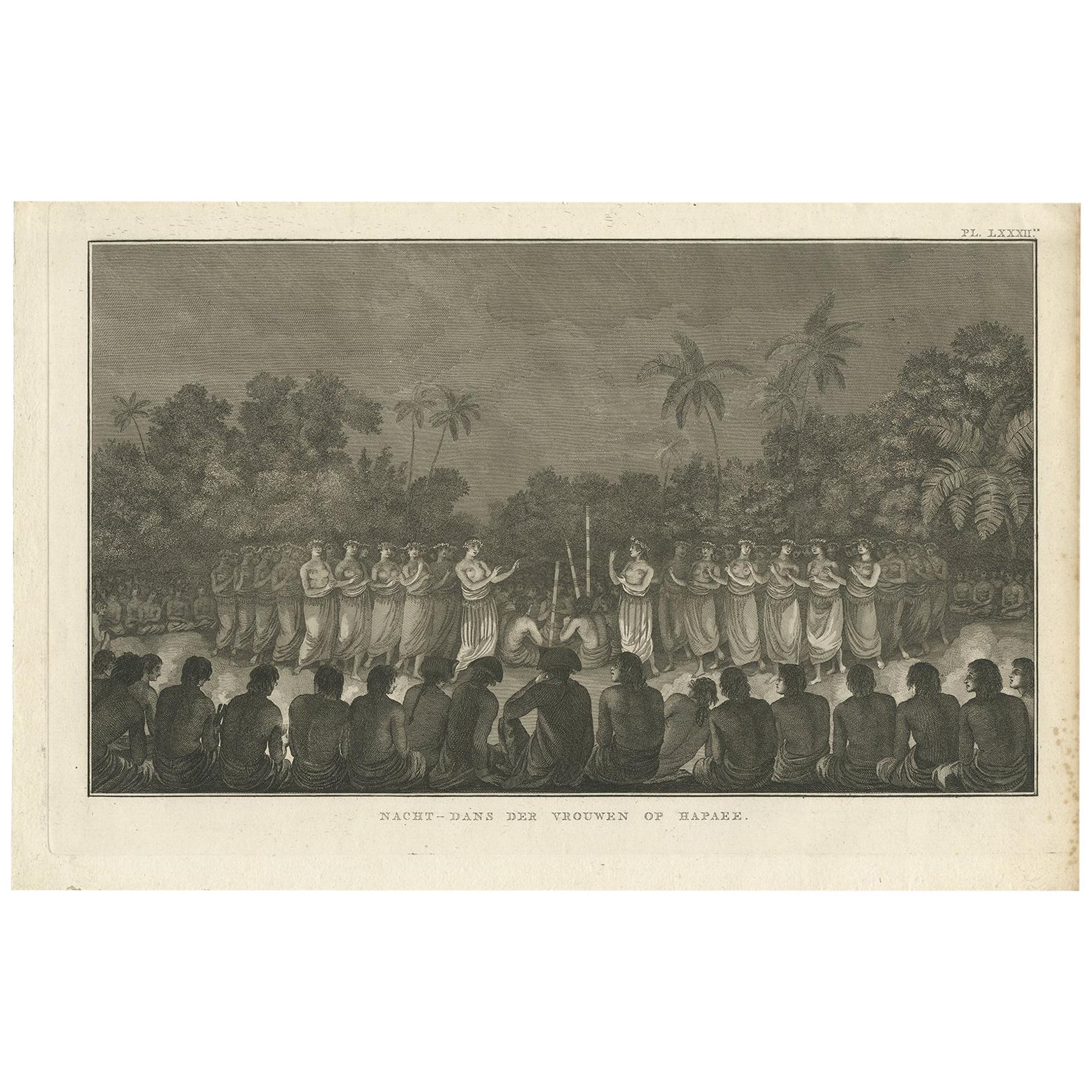
Antique Print of a Night Dance by Women from Hapaee by Cook, 1803
Located in Langweer, NL
Antique print titled 'Nacht-Dans Vrouwen op Hapaee'. This print depicts a night dance by women from Hapaee. Originates from 'Reizen rondom de Waereld' by J. Cook. Translated by J.D. ...
Category
Antique Early 19th Century Dutch Prints
Materials
Paper
$255 Sale Price
20% Off
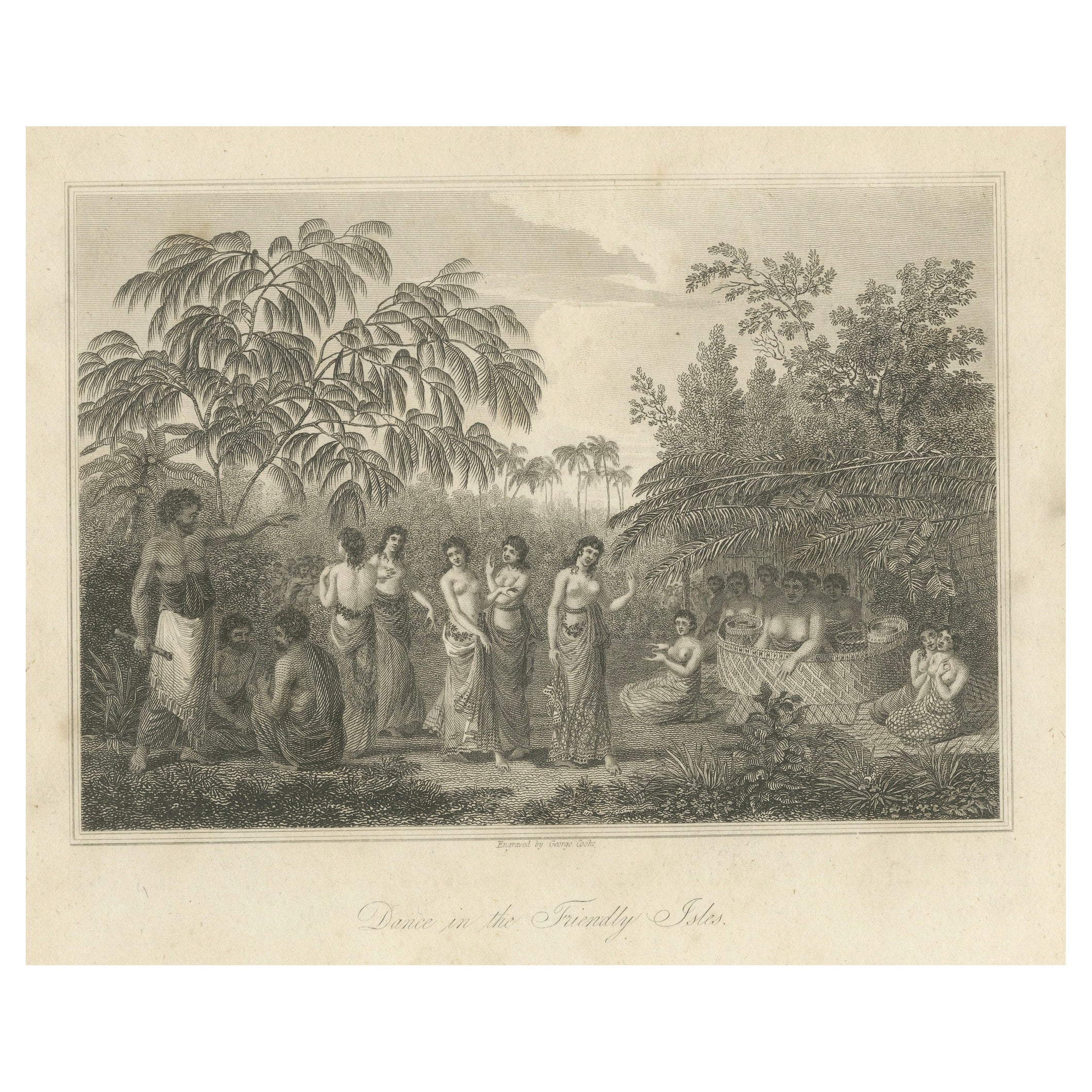
Rhythms of the Pacific: A Communal Dance in Tonga, Engraving Published in 1812
Located in Langweer, NL
The engraving depicts a serene and communal scene labeled as "Dance in the Friendly Isles." The Friendly Isles is an older name for the Kingdom of Tonga in the South Pacific. This pi...
Category
Antique Early 19th Century Prints
Materials
Paper
$246 Sale Price
20% Off
Free Shipping
Antique Print of a Night Dance by Men from Hapaee by Cook, 1803
Located in Langweer, NL
Antique print titled 'Nacht-Dans der Mannen op Hapaee'. This print depicts a night dance by men from Hapaee. Originates from 'Reizen rondom de Waereld' by J. Cook. Translated by J.D....
Category
Antique Early 19th Century Dutch Prints
Materials
Paper
$321 Sale Price
20% Off
A Dance in Otaheite (Tahiti) 1784 James Cook Final Voyage by John Webber
By John Webber
Located in Paonia, CO
A Dance in Otaheite ( Tahiti ) is from the 1784 First Edition Atlas Accompanying Capt. James Cook and King; Third and Final Voyage of Captain James Cook. John Webber (1752-1793) who...
Category
1780s Realist Figurative Prints
Materials
Engraving
Antique Copper Plate Engraving Depicting Natives of Tahiti Dancing, 1803
Located in Langweer, NL
Antique print titled 'Dans van O-Tahiti'.
Antique print depicting natives of Tahiti, dancing. Originates from 'Reizen Rondom de Waereld door James Cook (..)'.
Artists and Eng...
Category
Antique Early 1800s Prints
Materials
Paper
$331 Sale Price
20% Off
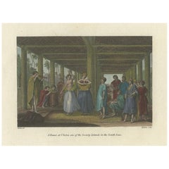
A Dance at Ulietea – Society Islands Scene from Cook’s Voyages, c.1784
Located in Langweer, NL
A Dance at Ulietea – Society Islands Scene from Cook’s Voyages, c.1784
This finely hand-colored copper engraving titled A Dance at Ulietea, one of the Society Islands in the South S...
Category
Antique Late 18th Century English Prints
Materials
Paper