Items Similar to The Loire Valley of France: A 17th C. Hand-colored Map by Sanson and Jaillot


Want more images or videos?
Request additional images or videos from the seller
1 of 10
Nicholas Sanson d'AbbevilleThe Loire Valley of France: A 17th C. Hand-colored Map by Sanson and Jaillot1692
1692
$1,740
$2,17520% Off
£1,340.29
£1,675.3720% Off
€1,530.46
€1,913.0720% Off
CA$2,482.15
CA$3,102.6820% Off
A$2,715.01
A$3,393.7620% Off
CHF 1,424.77
CHF 1,780.9620% Off
MX$32,469.97
MX$40,587.4620% Off
NOK 17,980.50
NOK 22,475.6220% Off
SEK 16,773.63
SEK 20,967.0420% Off
DKK 11,429.71
DKK 14,287.1420% Off
About the Item
This large 17th century copper plate hand-colored engraved map entitled "Gouvernement D'Orleans et la Generalite divisee en ses Elections Par le Sanson" was originally created by Nicholas Sanson d'Abbeville and published by Hubert Jaillot in "Atlas Nouveau" in Paris in 1693. It depicts the Loire Valley region of France. Chambort, Fontainbleau, the Loire River and many other landmarks are included. There is an ornate title cartouche in the right upper corner. A young male in the upper left lies on his back, drinking from a jug, presumably wine. A young male at the top on the right is sleeping in front of another liquid vessel, possibly after drinking too much wine. A royal coat-of-arms sits between the two figures. Bunches of grapes are aligned about the periphery of the cartouche. The Loire Valley was already known for its wine in the 17th century. A draped scale cartouche is in the left upper corner.
The map consists of two sheets joined as one along a vertical joint. The map has original hand-coloring. It is printed on antique hand-made laid, chain-linked paper with wide margins. The sheet measures 24.88" high and 38" wide. There is a central vertical joint, as issued. There are several spots and some discoloration at the periphery of the margins. There is some irregularity of the left and right edges of the sheet. There is a repaired tear in the lower margin to the right of the central vertical joint. The map itself is in very good condition.
Nicholas Sanson d'Abbeville (1600-1667) was one of the greatest French cartographather of French cartography. Sanson opened his first printing business in Paris in 1638. The king recognized his skill and knowledge and made him the official geographer to the court. He eventually served two kings in this capacity. Sanson was succeeded by his sons and son-in-law in the business and as geographers to the king. In 1692 his plates were purchased by the prominent Parisian cartographer Alexis Hubert Jaillot, who continued to publish his maps and atlases with a dual Sanson and Jaillot attribution. Jaillot went on to serve King Louis XIV.
- Creator:
- Creation Year:1692
- Dimensions:Height: 24.88 in (63.2 cm)Width: 38 in (96.52 cm)
- Medium:
- Period:1690-1699
- Condition:
- Gallery Location:Alamo, CA
- Reference Number:Seller: # 47561stDibs: LU117328935412

Nicholas Sanson d'Abbeville
Nicholas Sanson d'Abbeville (1600-1667) was one of the greatest French cartographather of French cartography. Sanson opened his first printing business in Paris in 1638. The king recognized his skill and knowledge and made him the official geographer to the court. He eventually served two kings in this capacity. Sanson was succeeded by his sons and son-in-law in the business and as geographers to the king. In 1692 his plates were purchased by the prominent Parisian cartographer Alexis Hubert Jaillot, who continued to publish his maps and atlases with a dual Sanson and Jaillot attribution. Jaillot went on to serve King Louis XIV.
About the Seller
5.0
Platinum Seller
Premium sellers with a 4.7+ rating and 24-hour response times
Established in 2011
1stDibs seller since 2019
298 sales on 1stDibs
Typical response time: 1 hour
- ShippingRetrieving quote...Shipping from: Alamo, CA
- Return Policy
More From This Seller
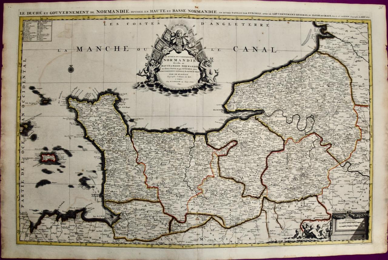
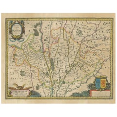
View AllThe Normandy Region of France: A 17th C. Hand-colored Map by Sanson and Jaillot
By Nicholas Sanson d'Abbeville
Located in Alamo, CA
This large hand-colored map entitled "Le Duché et Gouvernement de Normandie divisée en Haute et Basse Normandie en divers Pays; et par evêchez, avec le Gouvernement General du Havre ...
Category
1690s Landscape Prints
Materials
Engraving

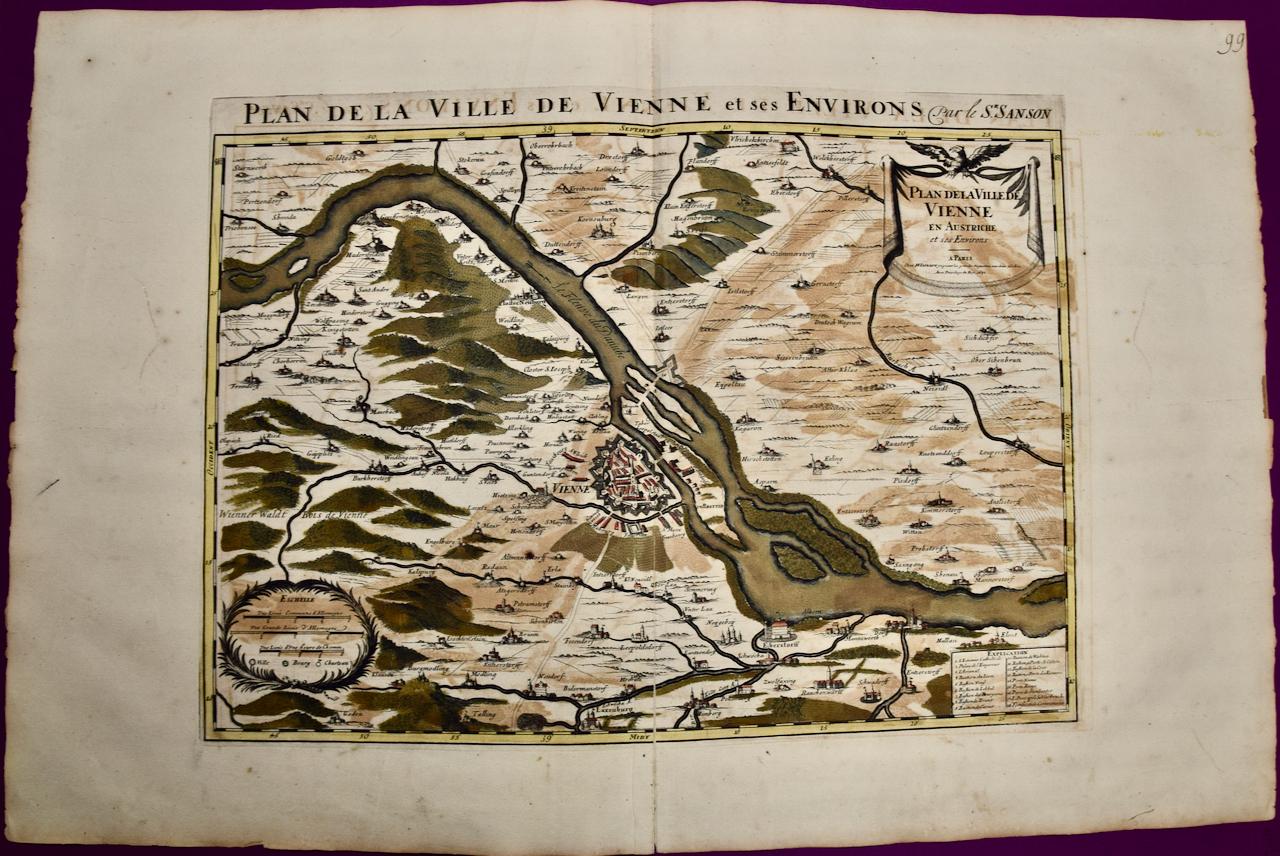
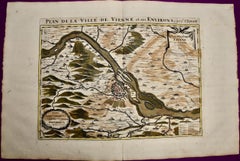
Vienna, Austria: A Large 17th Century Hand-colored Map by Sanson and Jaillot
By Nicholas Sanson d'Abbeville
Located in Alamo, CA
This large 17th century hand-colored map of Vienna, Austria and the surrounding countryside and villages entitled "Plan de la Ville de Vienne en Austrich...
Category
1690s Landscape Prints
Materials
Engraving
Southern Greece: A Large 17th Century Hand-colored Map By Sanson and Jaillot
By Nicholas Sanson d'Abbeville
Located in Alamo, CA
This large original hand-colored copperplate engraved map of southern Greece and the Pelopponese Peninsula entitled "La Moree Et Les Isles De Zante, Cefalonie, Ste. Marie, Cerigo & C...
Category
1690s Landscape Prints
Materials
Engraving

Great Britain, N. France: A Large 17th C. Hand-colored Map by Sanson and Jaillot
By Nicholas Sanson d'Abbeville
Located in Alamo, CA
This large hand-colored 17th century copperplate engraved map entitled "Le Royaume D Angleterre, distingué en ses Provinces. Par le Sr. Sanson. Geographe du Roy. Presenté A Monseigne...
Category
1690s Landscape Prints
Materials
Engraving

Hungary & Eastern Europe: A Large 17th C. Hand-colored Map by Sanson & Jaillot
By Nicholas Sanson d'Abbeville
Located in Alamo, CA
This large hand-colored map entitled "Le Royaume De Hongrie et les Estats qui en ont este sujets et qui font presentement La Partie Septentrionale de la Turquie en Europe" was origin...
Category
1690s Landscape Prints
Materials
Engraving

L'Isle de France: A Hand-colored 17th Century Map by De Wit
By Frederick de Wit
Located in Alamo, CA
This colorful and detailed 17th century hand-colored copperplate map by Frederick De Wit was published in Amsterdam between 1666 and 1760. The map depicts the Île-de-France, which is one of the ancient provinces of France. Paris is located in the center of the map, with Versailles to the southwest The map extends from Rouen in the west to Reims in the east. The area around Paris, the Véxin Français, was the original domain of the king of France. Other areas were ruled by French feudal lords. For example, the Véxin Normand area was the domain of the Duke of Normandy...
Category
Early 18th Century Old Masters More Prints
Materials
Engraving

$940 Sale Price
20% Off
You May Also Like
Rare Hand-Colored Map of Lorraine and Barrois, France by Frederik De Wit c. 1688
Located in Langweer, NL
Title: Rare Hand-Colored Map of Lorraine and Barrois by Frederik De Wit c. 1688
Description: This remarkable 17th-century map, titled "Generalis Lotharingiae Ducatus," offers a deta...
Category
Antique 1680s Maps
Materials
Paper

Hand-Colored 17th-Century Map of Orléanais in France by Frederik De Wit c. 1688
Located in Langweer, NL
Title: Hand-Colored 17th-Century Map of Orléanais by Frederik De Wit c. 1688
Description: This beautifully crafted map, "Gouvernement General du Pays Orléanois," illustrates the Orl...
Category
Antique 1680s Maps
Materials
Paper

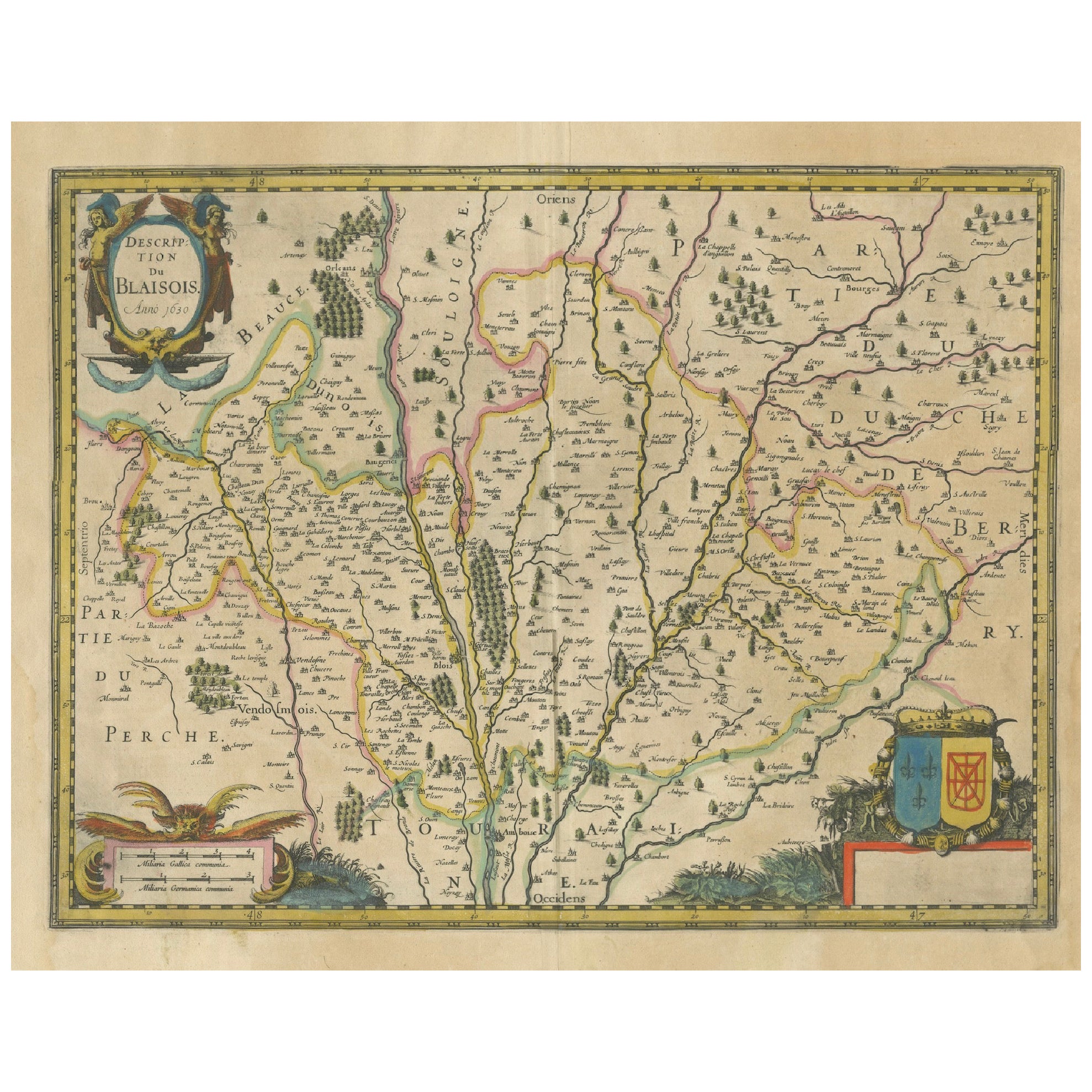
Map of Blaisois by Janssonius, 1633, Decorative Antique Map of Loire Valley
Located in Langweer, NL
Map of Blaisois by Janssonius, 1633, Decorative Antique Map of Loire Valley
This finely detailed and colorfully embellished map titled 'Description du Blaisois' was published in 163...
Category
Antique 1630s Maps
Materials
Paper
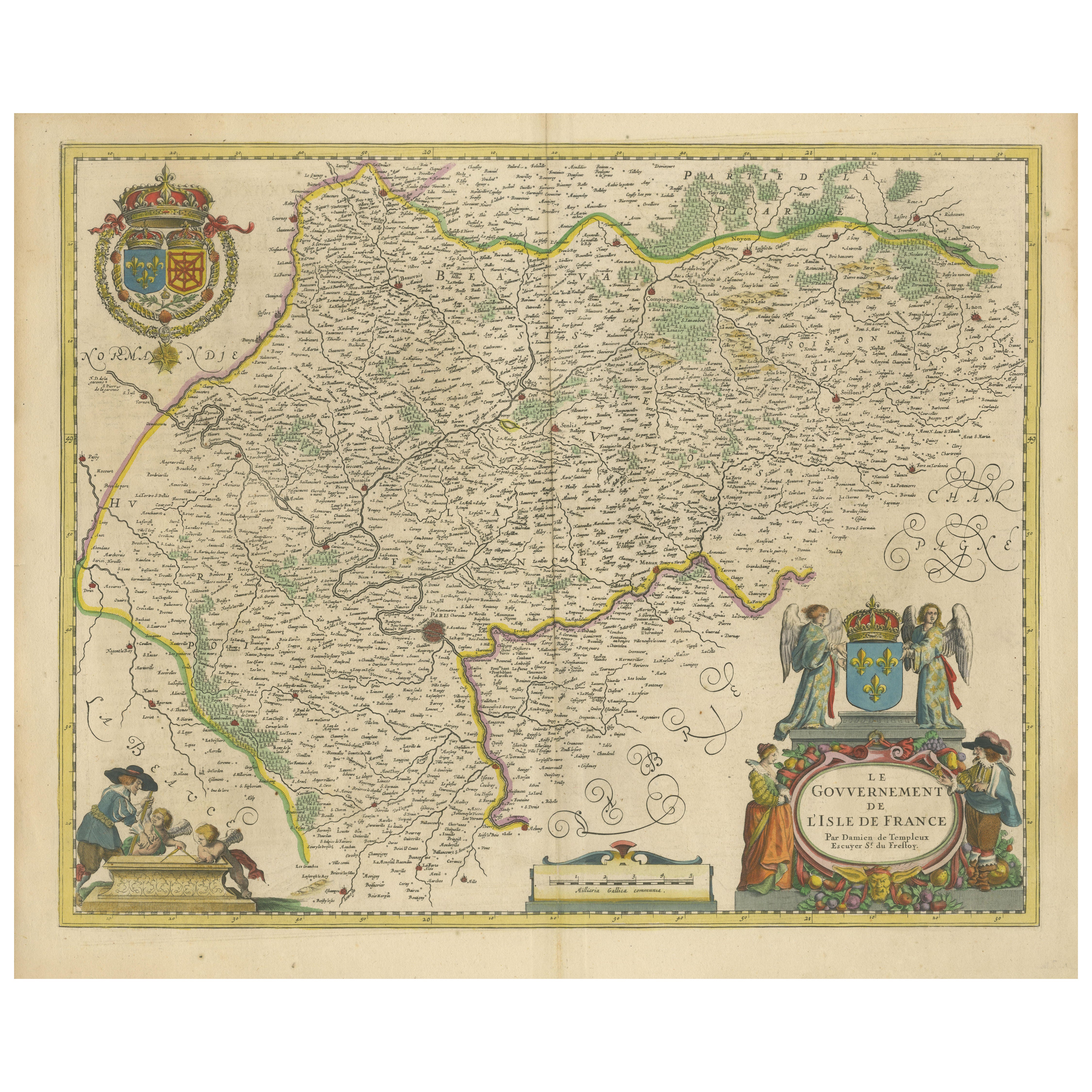
Beautiful 17th Century Map of Paris and Isle de France by Templeux, c.1650
Located in Langweer, NL
Map of Isle de France by D. de Templeux, ca. 1650, Hand-Colored and Decorative
This richly detailed antique map titled *Le Gouvernement de L'Isle de France* was engraved by Daniel d...
Category
Antique 1650s Maps
Materials
Paper

Gascogne and Guyenne Map - Hand-Colored 17th-Century Engraving by De Wit, c.1688
Located in Langweer, NL
Title: Gascogne and Guyenne Map - Hand-Colored 17th-Century Engraving by Frederik De Wit c. 1688
Description: This remarkable map, "Gouvernement de la Guyenne & Gascogne," captures ...
Category
Antique 1680s Maps
Materials
Paper
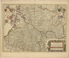
Rare Hand-Colored Map of Lyonnais Region in France by Frederik De Wit c. 1688
Located in Langweer, NL
Title: Rare Hand-Colored Map of Lyonnais Region by Frederik De Wit c. 1688
Description: This beautifully detailed map, "Gouvernement General du Lyonnois," showcases the Lyonnais reg...
Category
Antique 1680s Maps
Materials
Paper

More Ways To Browse
Antique Hand Chain
King Louis Xiv
17th Century Copper
Antique Wine Jugs
Hand Colored French Engravings
Large Copper Plate
Wine 17th
17th Century Copper Plate
Tattoo Nude
Toshio Iezumi
Used Cremation Urns
Vintage Beach Boys
Vintage Electric Chair
Vintage Taxi Cabs
Wild Bunch
Yves Klein Blue
1950 Fashion Illustrations
Antique Poster Food