Items Similar to Portugal: A Large 17th Century Hand-colored Map by Sanson and Jaillot


Want more images or videos?
Request additional images or videos from the seller
1 of 13
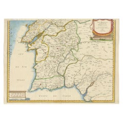
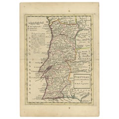
Nicholas Sanson d'AbbevillePortugal: A Large 17th Century Hand-colored Map by Sanson and Jaillot1695
1695
$1,740
$2,17520% Off
£1,350.23
£1,687.7820% Off
€1,524.49
€1,905.6220% Off
CA$2,489.78
CA$3,112.2220% Off
A$2,716.80
A$3,39620% Off
CHF 1,405.59
CHF 1,756.9820% Off
MX$32,501.11
MX$40,626.3920% Off
NOK 17,755.92
NOK 22,194.9120% Off
SEK 16,672.54
SEK 20,840.6720% Off
DKK 11,385.25
DKK 14,231.5620% Off
About the Item
This large hand-colored map entitled "Le Royaume de Portugal et des Algarves Divisee en see Archeveches, Eveches et Territoires Par le Sr Sanson" was originally created by Nicholas Sanson d'Abbeville and published by Hubert Jaillot in "Atlas Nouveau" in Paris in 1695. It depicts Portugal, including at the time a separate kingdom of Algarve, and a portion of western Spain. Lisbon and Porto are shown along the west coast of Portugal and Seville in southwestern Spain, along with the Douro River and many other landmarks. There is an ornate title cartouche in the left upper corner which includes multiple naked infants at the feet of mythical-style gods, one sitting in front of a tall tree. The title plaque is topped by a royal coat-of-arms. In the lower left corner a putti and another mythical style god are holding a royal coat-of-arms while sitting on top of a large pedestal containing a scale cartouche.
The map consists of two sheets joined as one along a horizontal joint. The map has original hand-coloring and it is printed on antique hand-made laid, chain-linked paper with wide margins. The sheet measures 38" high and 24.88" wide. There are occasional tiny spots and minimal color offset resulting from contact with the color on the opposite sides of the map over hundreds of years in the atlas. The map is otherwise in very good to excellent condition.
Nicholas Sanson d'Abbeville (1600-1667) was one of the greatest French cartographather of French cartography. Sanson opened his first printing business in Paris in 1638. The king recognized his skill and knowledge and made him the official geographer to the court. He eventually served two kings in this capacity. Sanson was succeeded by his sons and son-in-law in the business and as geographers to the king. In 1692 his plates were purchased by the prominent Parisian cartographer Alexis Hubert Jaillot (1632-1712), who continued to publish his maps and atlases with a dual Sanson and Jaillot attribution. Jaillot went on to serve King Louis XIV.
- Creator:
- Creation Year:1695
- Dimensions:Height: 38 in (96.52 cm)Width: 24.88 in (63.2 cm)
- Medium:
- Period:1690-1699
- Framing:Framing Options Available
- Condition:
- Gallery Location:Alamo, CA
- Reference Number:Seller: # 47591stDibs: LU117328938292
Nicholas Sanson d'Abbeville
Nicholas Sanson d'Abbeville (1600-1667) was one of the greatest French cartographather of French cartography. Sanson opened his first printing business in Paris in 1638. The king recognized his skill and knowledge and made him the official geographer to the court. He eventually served two kings in this capacity. Sanson was succeeded by his sons and son-in-law in the business and as geographers to the king. In 1692 his plates were purchased by the prominent Parisian cartographer Alexis Hubert Jaillot, who continued to publish his maps and atlases with a dual Sanson and Jaillot attribution. Jaillot went on to serve King Louis XIV.
About the Seller
5.0
Platinum Seller
Premium sellers with a 4.7+ rating and 24-hour response times
Established in 2011
1stDibs seller since 2019
294 sales on 1stDibs
Typical response time: 1 hour
- ShippingRetrieving quote...Shipping from: Alamo, CA
- Return Policy
More From This Seller
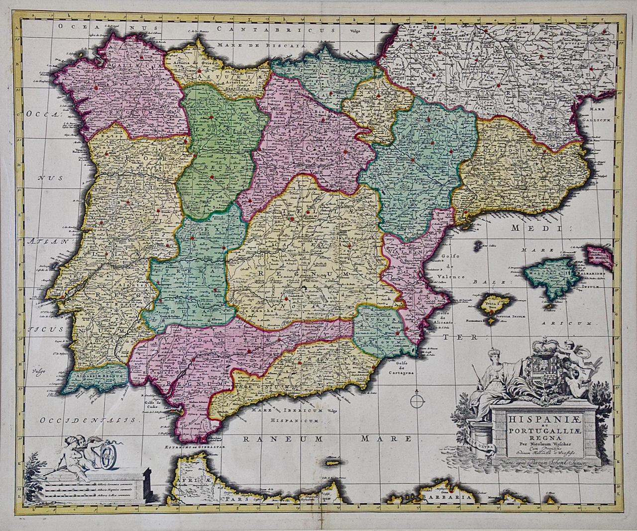
View AllSpain and Portugal: A Hand-colored 17th/18th Century Map by Visscher
By Nicolaus Visscher
Located in Alamo, CA
This is an early 18th century map of Spain and Portugal, with attractive original hand-coloring, entitled "Hispaniae et Portugalliae Regna per Nicolaum Visscher cum Privilegio Ordinum Hollandiae et Westfrisiae" first published by Nicolaes Visscher II (1649-1702) in 1688, and later re-published from Visscher's original copper plate by Peter Schenk, Junior in Amsterdam in 1725. The cartouche in the right lower corner depicts a coat of arms representing one combined kingdom of Spain and Portugal before their break-up. Putti hold up the coat-of-arms of Phillip II on the right and a queen reaches for it on the left. There is a scale cartouche in the lower left corner surmounted by two putti and a wheel. This is an outstanding depiction of the Iberian peninsula, showing Spain and Portugal and Balearic Islands. The map includes portions of North Africa and the Strait of Gibralter.
This copperplate engraved map is presented in a cream-colored mat. It is printed on fine chain-linked, laid paper. The mat measures 26.5" high by 30" wide and the sheet measures 21.75" high by 26.375" wide. There is a central fold, as issued. The lower portion of the fold is reinforced on the verso. There is a small paper defect at the lower edge of the fold and another at the edge of the right corner, as well as a few small tears along the lower edge; none affecting the map and all covered by the mat. There are a few small faint spots in the upper margin and on the left. The map is otherwise in very good condition.
The Visscher family were one of the great art and cartographic printing families of the 17th century. Begun by Claes Jansz Visscher...
Category
Late 17th Century Other Art Style Landscape Prints
Materials
Engraving

$1,020 Sale Price
20% Off
Southern Greece: A Large 17th Century Hand-colored Map By Sanson and Jaillot
By Nicholas Sanson d'Abbeville
Located in Alamo, CA
This large original hand-colored copperplate engraved map of southern Greece and the Pelopponese Peninsula entitled "La Moree Et Les Isles De Zante, Cefalonie, Ste. Marie, Cerigo & C...
Category
1690s Landscape Prints
Materials
Engraving

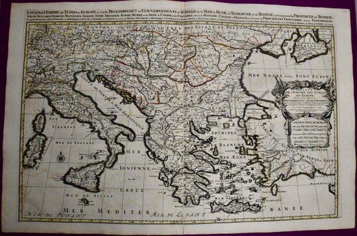
Southern & Eastern Europe: A Large 17th C. Hand-colored Map by Sanson & Jaillot
By Nicholas Sanson d'Abbeville
Located in Alamo, CA
This large hand-colored map entitled "Estats de L'Empire des Turqs en Europe, ou sont les Beglerbeglicz our Gouvernements" was originally created by Nicholas Sanson d'Abbeville and this version was published by Hubert Jaillot in "Atlas Nouveau" in Paris in 1692. It depicts the territories of the Ottoman Empire in Europe, predominantly Eastern Europe. Highlights include, the Mediterranean Sea, the Adriatic Sea, the Black Sea, the Dalmation Coast including present day Croatia, Bosnia and Herzegovina, Montenegro, Serbia, Slovenia, Italy, Greece, North Macedonia, Turkey, Romania, Hungary, Albania, Kosovo, Bulgaria, Transylvania, Moldova and southern portions of France, Switzerland, Germany, and Poland..
The map consists of two sheets joined as one along a vertical joint. The map has original hand-coloring. It is printed on antique hand-made laid, chain-linked paper with wide margins. The sheet measures 24.88" high and 38" wide. There is a central vertical joint, as issued. The map is in very good condition.
Nicholas Sanson d'Abbeville (1600-1667) was one of the greatest French cartographather of French cartography. Sanson opened his first printing business in Paris in 1638. The king recognized his skill and knowledge and made him the official geographer to the court. He eventually served two kings in this capacity. Sanson was succeeded by his sons and son...
Category
1690s Landscape Prints
Materials
Engraving

Great Britain, N. France: A Large 17th C. Hand-colored Map by Sanson and Jaillot
By Nicholas Sanson d'Abbeville
Located in Alamo, CA
This large hand-colored 17th century copperplate engraved map entitled "Le Royaume D Angleterre, distingué en ses Provinces. Par le Sr. Sanson. Geographe du Roy. Presenté A Monseigne...
Category
1690s Landscape Prints
Materials
Engraving

The Normandy Region of France: A 17th C. Hand-colored Map by Sanson and Jaillot
By Nicholas Sanson d'Abbeville
Located in Alamo, CA
This large hand-colored map entitled "Le Duché et Gouvernement de Normandie divisée en Haute et Basse Normandie en divers Pays; et par evêchez, avec le Gouvernement General du Havre ...
Category
1690s Landscape Prints
Materials
Engraving

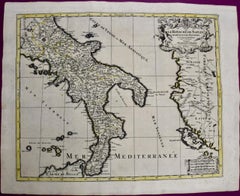
Naples and S. Italy: A Large 17th C. Hand-colored Map by Sanson and Jaillot
By Nicholas Sanson d'Abbeville
Located in Alamo, CA
This large hand-colored map entitled "Le Royaume de Naples Divisé en Douze Provinces. sur les Memoires les plus Nouveaux. Par le Sr. Sanson Presenté" was originally created by Nicholas Sanson d'Abbeville and published by Hubert Jaillot in "Atlas Nouveau" in Paris in 1692. It depicts central and southern Italy, as well as Corfu, Albania, Mediterranean Sea and the Adriatic Sea. Naples, Sorrento, the Isle of Capri, Rome in the upper left corner of the map, as well as many other landmarks.
This striking original hand-colored map of Italy is printed on antique hand-made laid, chain-linked paper with wide margins. The sheet measures 20" high and 24.88" wide. There is one spot on the left, it is otherwise in very good to excellent condition.
Nicholas Sanson d'Abbeville (1600-1667) was one of the greatest French cartographather of French cartography. Sanson opened his first printing business in Paris in 1638. The king recognized his skill and knowledge and made him the official geographer to the court. He eventually served two kings in this capacity. Sanson was succeeded by his sons and son...
Category
1690s Landscape Prints
Materials
Engraving
You May Also Like
17th Century Map of Southern Portugal by Sanson – Hand-Colored, 1679
Located in Langweer, NL
17th Century Map of Southern Portugal by Sanson – Hand-Colored, 1679
This stunning 1679 map of Portugal offers a captivating glimpse into the past, showcasing the country's geograph...
Category
Antique Late 17th Century French Maps
Materials
Paper
Antique Map of Portugal by P. Schenk, circa 1700
Located in Langweer, NL
Antique map titled 'Portugalliae et Algarbia'. Striking example of Schenk's rare map of Portugal, with the coats of arms of Portugal, Algarbia and a Spanish sailing vessell in the ca...
Category
Antique Early 18th Century Maps
Materials
Paper

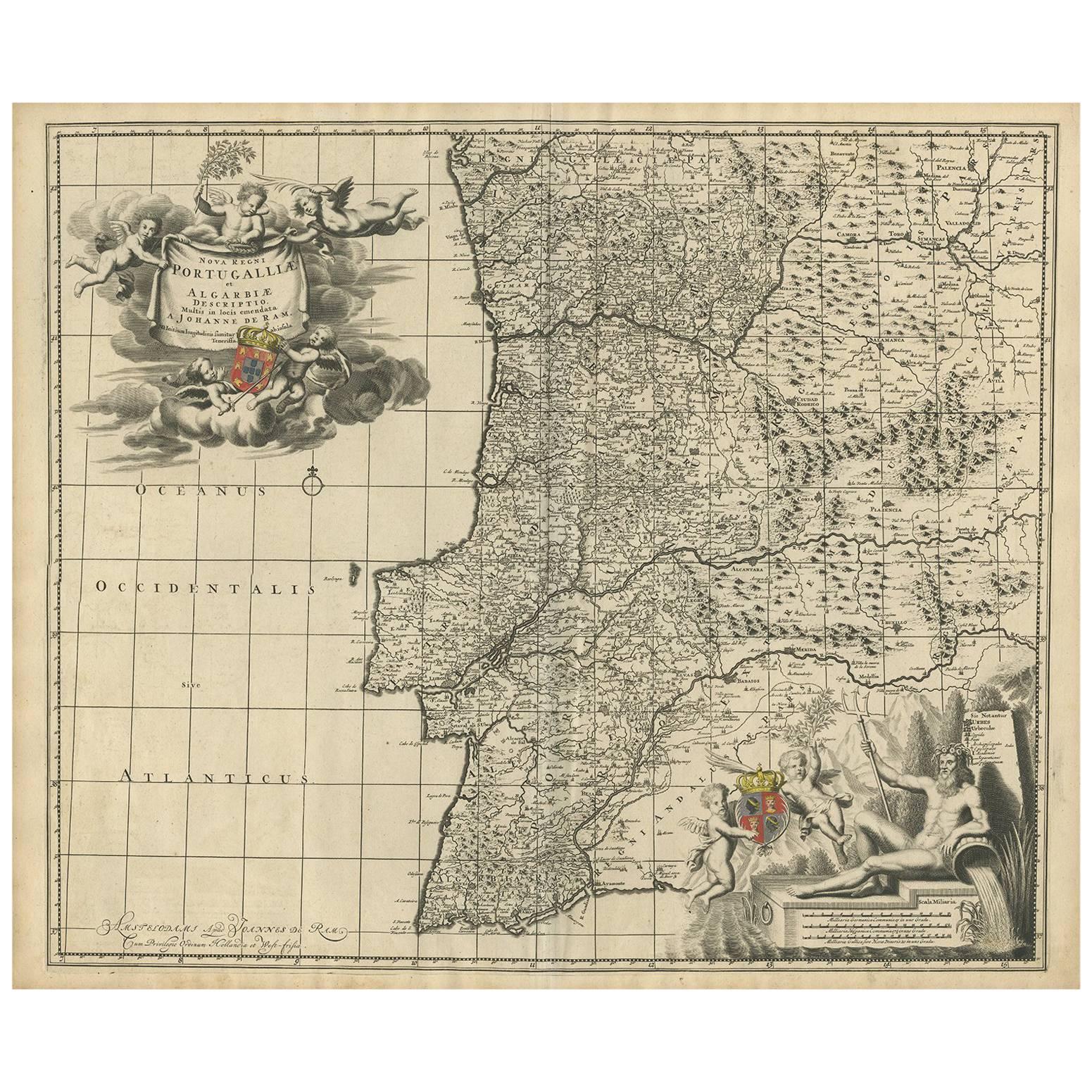
Antique Map of Portugal by J. De Ram, circa 1680
Located in Langweer, NL
A detailed map of Portugal. Embellished with beautiful cartouche, sailing vessels and many putti. Very rare edition by J. de Ram, circa 1680.
Category
Antique Late 17th Century Maps
Materials
Paper
$769 Sale Price
20% Off
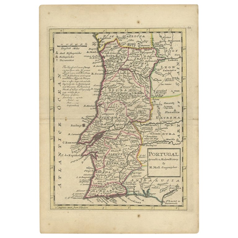
Antique Map of Portugal by Moll, 1727
Located in Langweer, NL
Antique map Portugal titled 'Portugal Agreeable to Modern History'. Detailed map of Portugal showing major routes, waterways, arch bishoprics, bis...
Category
Antique 18th Century Maps
Materials
Paper
$188 Sale Price
20% Off
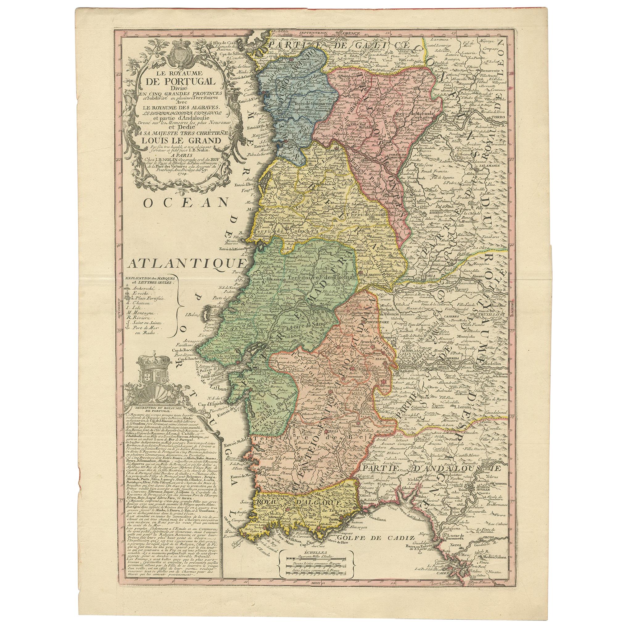
Antique Map of Portugal by Nolin '1704'
Located in Langweer, NL
Antique map titled 'Le Royaume de Porutgal divisé en cinq grandes Provinces (..)'. Rare and very decorative map of Portugal. It shows the territory of ...
Category
Antique Early 18th Century Maps
Materials
Paper

Detailed Antique Map of Portugal, Published for the 'Gentleman's Magazine', 1758
Located in Langweer, NL
Antique map Portugal titled 'A Map of the Kingdom of Portugal'.
Detailed map of Portugal, published for the 'Gentleman's Magazine'.
Artist...
Category
Antique 1750s Maps
Materials
Paper
$455 Sale Price
20% Off
More Ways To Browse
Antique Hand Chain
King Louis Xiv
Lisbon Antique
17th Century Portuguese
Tattoo Nude
Toshio Iezumi
Used Cremation Urns
Vintage Beach Boys
Vintage Electric Chair
Vintage Taxi Cabs
Wild Bunch
Yves Klein Blue
1950 Fashion Illustrations
Antique Poster Food
Arman Resin
Baroque Painting Angel
Botanical Print Rose
Bronze Hippo