Items Similar to A Map of the Colne Valley Cloth District, West Yorkshire by Max Gill

Want more images or videos?
Request additional images or videos from the seller
1 of 10
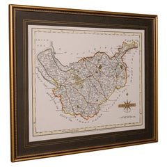
Leslie Macdonald "Max" GillA Map of the Colne Valley Cloth District, West Yorkshire by Max Gill1946
1946
$567.81
£425
€493.10
CA$801.70
A$879.77
CHF 459.51
MX$10,518.61
NOK 5,820.47
SEK 5,428.69
DKK 3,682.80
About the Item
To see our other original maps, scroll down to "More from this Seller" and below it click on "See all from this Seller" - or send us a message if you cannot find the poster you want.
Leslie Macdonald "Max" Gill (1884 - 1947)
A Map of the Colne Valley Cloth District (1946)
Lithograph
32 x 48 cm
Signed in the plate and dated 1946. Produced for Huddersfield and District Woollen Export Group.
Gill's vibrant and detailed map depicts the Colne Valley District. The Colne Valley was a loom-weaving area which played a significant role in the development of the Industrial Revolution when water-powered textile mills were brought in.
Born in Brighton, Max Gill was the second son in a family of thirteen children; his elder brother was Eric Gill, the typographer and sculptor. Both Gills exhibited significant talent at a young age. Max Gill’s first map was made for a school map-drawing project following which he entered maps into competitions in boys’ magazines.
In 1903 he moved to London as assistant to the ecclesiastical architects Sir Charles Nicholson and Hubert Corlette. By 1908 he had started his own architectural practice, but in 1909 Sir Edwin Lutyens commissioned Gill to paint a “wind dial” map for Nashdom, a large house in Buckinghamshire. The wind dial was set over the fireplace and attached to a weather vane on the roof, allowing the occupant to know the direction of the wind from the comfort of the house. He produced seven further wind dials including for Lutyens’s Lindisfarne Castle and for the Allhusen Room at Trinity College, Cambridge.
Although Gill continued to practice as an architect, Frank Pick commissioned him to create seven pictorial maps for the Underground, the first being the famous 1913 ‘Wonderground Map of London Town.’
In 1917 he joined the Imperial War Graves Commission’s headstone design committee, designing the typeface and regimental badges. Gill’s memorials for the fallen in the First World War include for Balliol and Worcester Colleges and Christ Church in Oxford.
During the 1920s and 30s Gill undertook many commercial commissions for advertising materials. The Empire Marketing Board and Shell-Mex as well as further maps for the Underground. He designed in 1922 the first diagrammatic map of the Underground which provided the foundation for Beck’s more famous map.
By the 1930s his major works were murals. Those of the Arctic and Antarctic on the ceilings of the Scott Polar Research Institute in Cambridge are beautiful, but the most impressive is the map of the North Atlantic in the first-class dining room of the Queen Mary (maiden voyage: 1936, now moored at Long Beach, California).
During the Second World War he created a series of propaganda posters for the Ministry of Information.
- Creator:Leslie Macdonald "Max" Gill (1884 - 1947, British)
- Creation Year:1946
- Dimensions:Height: 12.6 in (32 cm)Width: 18.9 in (48 cm)
- Medium:
- Period:
- Condition:Very good. In new hand-finished frame.
- Gallery Location:London, GB
- Reference Number:1stDibs: LU795313435822
About the Seller
4.8
Vetted Professional Seller
Every seller passes strict standards for authenticity and reliability
Established in 2014
1stDibs seller since 2017
361 sales on 1stDibs
Typical response time: 13 hours
- ShippingRetrieving quote...Shipping from: London, United Kingdom
- Return Policy
More From This Seller
View AllJohn Speede, Map of the County of Surrey, described and divided into hundreds
By John Speed
Located in London, GB
To see our other views and maps of England - including London, Oxford and Cambridge, scroll down to "More from this Seller" and below it click on "See all from this Seller" - or send us a message if you cannot find the view you want.
John Speed/Speede (1551/2-1629)
The County of Surrey Described and Divided into Hundreds
Engraving with later hand colouring and text to the reverse.
Dated to c.1650
36 x 49 cm
Probably the most famous early English mapmaker, John Speed's early life is somewhat of an enigma. He is believed to have trained as a rolling-press printer, but he was at heart an historian granted a sinecure in the Customs House by Queen Elizabeth to indulge his passion, later becoming a Fellow of the Society of Antiquaries. His first maps were historical, of the Holy Land 'Canaan as it was Possessed both in Abraham and Israels Dayes' and of England and Ireland recording 'all their Civill Warres since the Conquest'.
In 1611 he published his 'Hostory of Great Britaine' which he regarded as his magnum opus, but it was the companion atlas 'Theatre of the Empire of Great Britaine' that - as the first printed atlas of Great Britain - sealed his reputation. William Rogers engraved the first map, 'the County Palatine of Chester' in about 1600, but following his untimely death the task of engraving was passed to Jodocus Hondius of Amsterdam.
By 1612 the atlas was complete, the maps famed for their decorative elements. Many have town plans - Britain's first series of such plans - and descriptive text was printed to the reverse until the 1676 edition. Later printings (up until 1770) were issued without this text. By 1627 it has become a part of a world atlas 'Prospect of the Most Famous Parts of the World'. During the 17th century the plates passed through the hands of a series of publishers, the 1676 edition of Thomas Bassett and Richard Chiswell being regarded as its high point with the inclusion for the first time of a series of important maps. For the first half of the eighteenth century they were firmly established in the hands of the Overton family.
This particular edition originally featured in The Theatre Of The Empire Of Great Britaine. It features attractive inset views of the long-since destroyed Richmond...
Category
17th Century Realist Landscape Prints
Materials
Engraving
Map of Oxfordshire coloured 18th century engraving by Thomas Kitchin
By Thomas Kitchin
Located in London, GB
To see our other original maps, scroll down to "More from this Seller" and below it click on "See all from this Seller" - or send us a message if you cannot find the poster you want....
Category
1760s Landscape Prints
Materials
Engraving

Wonderground Map of London by MacDonald 'Max' Gill c. 1924 original poster
By "Leslie MacDonald ""Max"" Gill"
Located in London, GB
To see our other original vintage posters and views of London (including original paintings), scroll down to "More from this Seller" and below it click on "See all from this Seller" ...
Category
1920s Modern Landscape Prints
Materials
Lithograph
John Speede Map The Countye Palatine of Chester with that most ancient citie
By John Speed
Located in London, GB
To see our other views and maps of England - including London, Oxford and Cambridge, scroll down to "More from this Seller" and below it click on "See all from this Seller" - or send...
Category
17th Century Realist Landscape Prints
Materials
Engraving
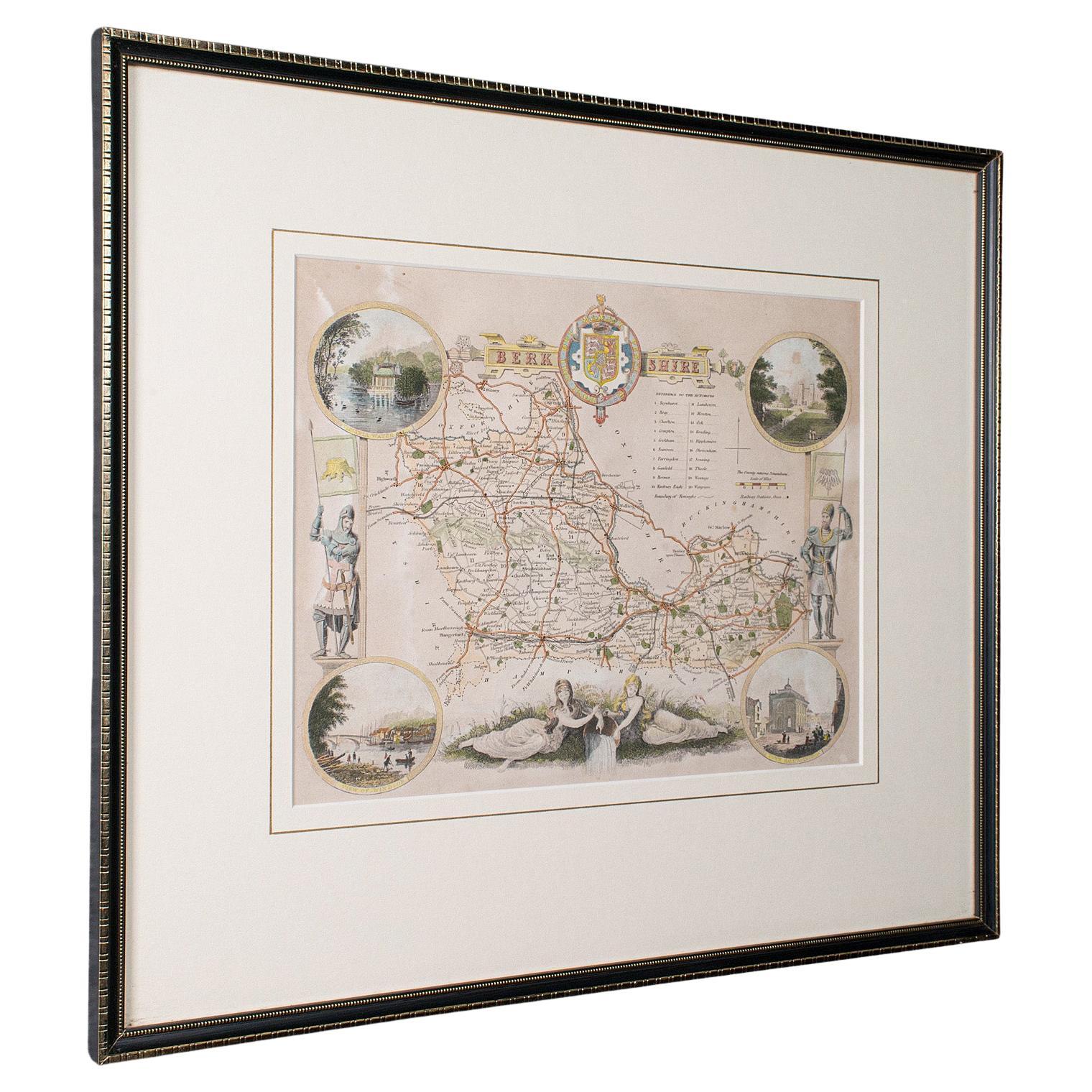
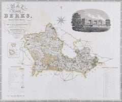
Berkshire 19th century map engraved by John Dower
Located in London, GB
To see more, scroll down to "More from this Seller" and below it click on "See all from this Seller."
John Dower (1825 - 1901)
Map of Berkshire from an actual survey made in the ye...
Category
1820s Prints and Multiples
Materials
Engraving
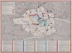
1937 Coronation Map for London Transport
Located in London, GB
To see more, scroll down to "More from this Seller" and below it click on "See all from this Seller."
Coronation Arrangements – Map of London (1...
Category
1950s Landscape Prints
Materials
Lithograph
You May Also Like
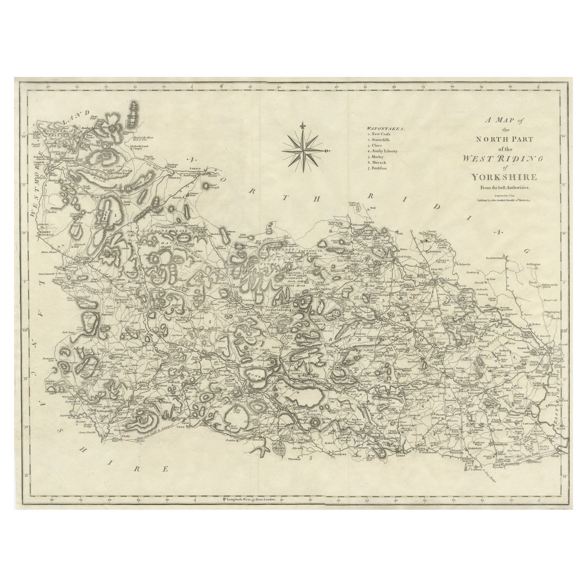
Large Antique County Map of the West Riding of Yorkshire 'North Part', England
Located in Langweer, NL
Antique map titled 'A Map of the North Part of the West Riding of Yorkshire from the best Authorities'. Original old county map of the north part of the West Riding of Yorkshire, Eng...
Category
Antique Early 19th Century Maps
Materials
Paper
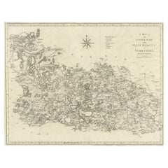
$263 Sale Price
20% Off
Antique West Yorkshire Map, English, Framed Lithography, Cartography, Victorian
Located in Hele, Devon, GB
This is an antique lithography map of West Yorkshire. An English, framed atlas engraving of cartographic interest, dating to the mid 19th century and later.
Superb lithography of t...
Category
Antique Mid-19th Century British Victorian Maps
Materials
Paper

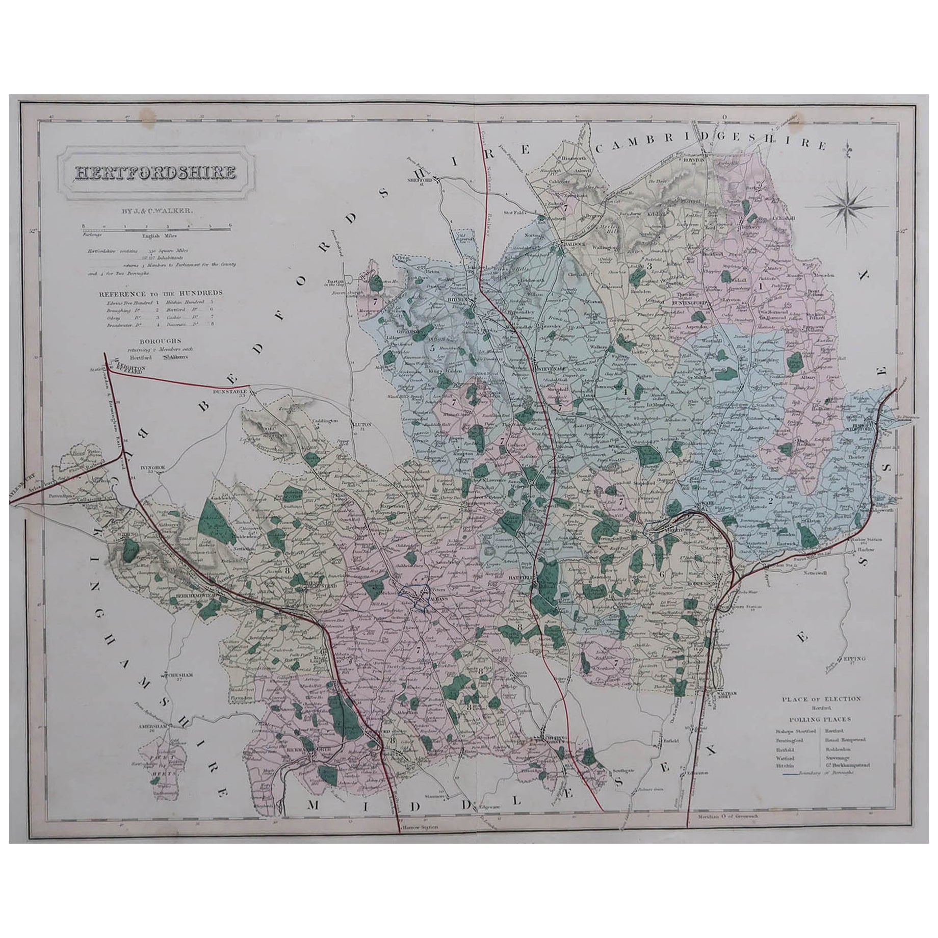
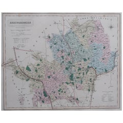
Original Antique English County Map, Hertfordshire. J & C Walker, 1851
Located in St Annes, Lancashire
Great map of Hertfordshire
Original colour
By J & C Walker
Published by Longman, Rees, Orme, Brown & Co. 1851
Unframed.
Category
Antique 1850s English Other Maps
Materials
Paper
Vintage County Map of Cheshire, English, After John Cary, Cartography Interest
Located in Hele, Devon, GB
This is a vintage Cheshire map, a fine reproduction of John Cary’s late 18th century cartography, and presented within a smart glazed frame.
Superb county map of Cheshire, offering ...
Category
Vintage 1980s British Georgian Maps
Materials
Glass, Paper
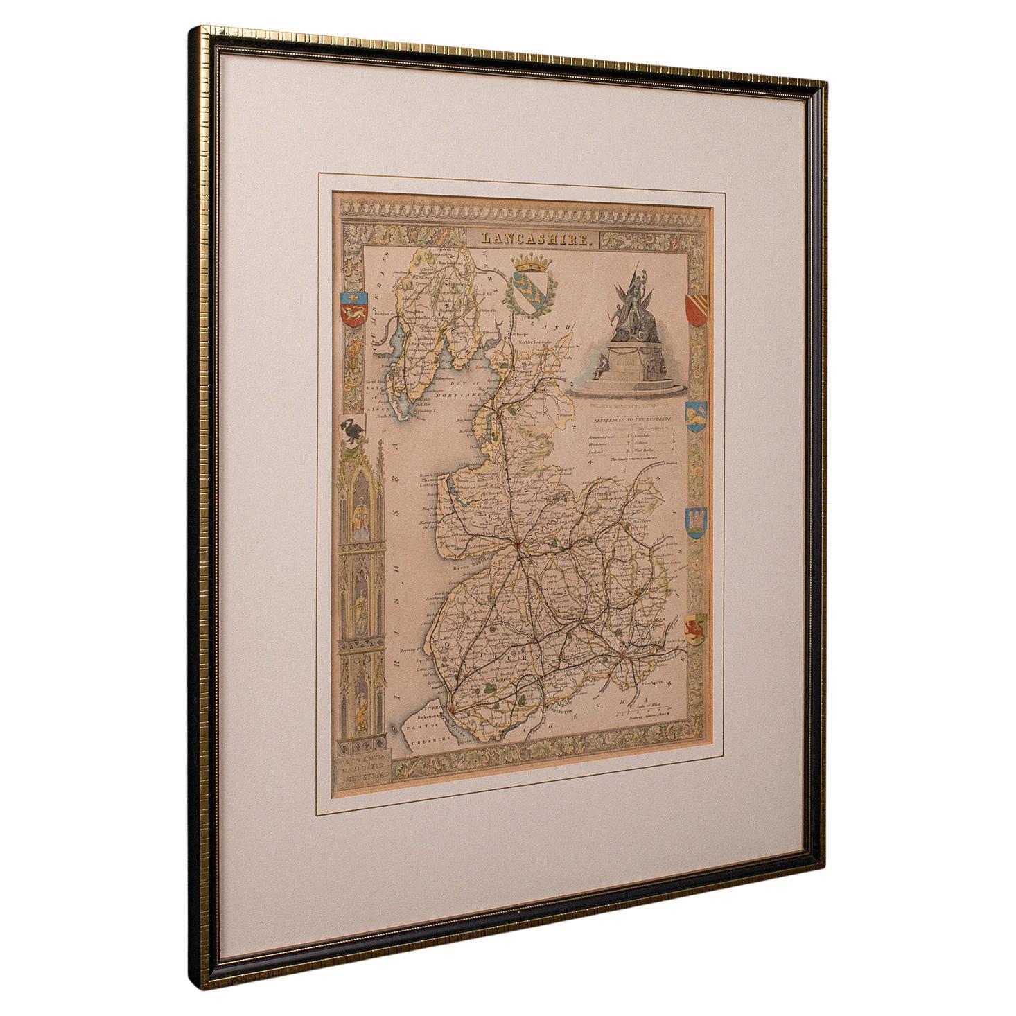
Antique County Map, Lancashire, English, Framed Lithography, Cartography, C.1860
Located in Hele, Devon, GB
This is an antique lithography map of Lancashire. An English, framed atlas engraving of cartographic interest, dating to the mid 19th century and later.
Superb lithography of Lanca...
Category
Antique Mid-19th Century British Victorian Maps
Materials
Glass, Wood, Paper

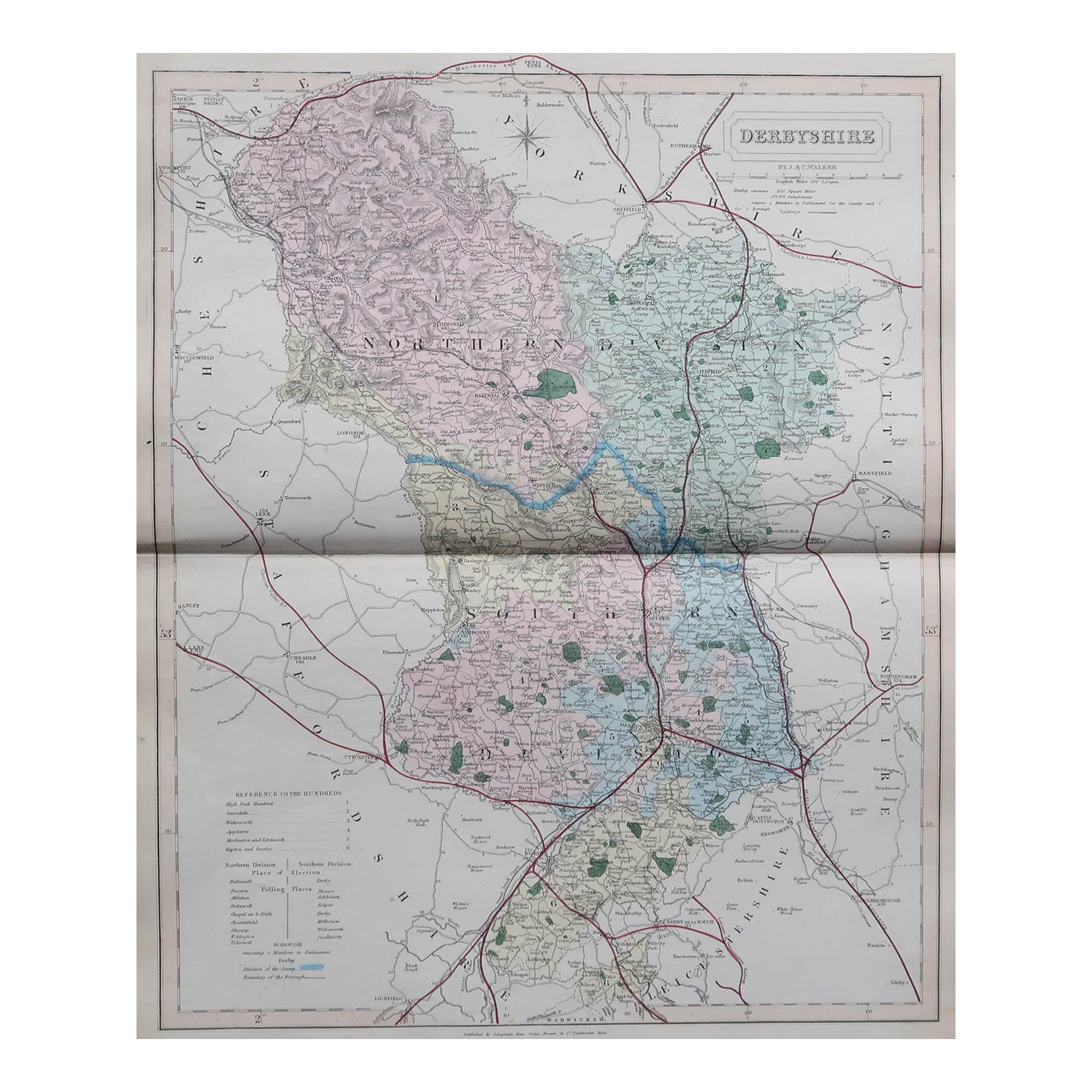
Original Antique English County Map, Derbyshire, J & C Walker, 1851
Located in St Annes, Lancashire
Great map of Derbyshire
Original colour
By J & C Walker
Published by Longman, Rees, Orme, Brown & Co. 1851
Unframed.
Category
Antique 1850s English Other Maps
Materials
Paper

More Ways To Browse
Vintage Gill
Map Of London
Used Weaving Looms
Queen Mary Vintage
Pictorial Map
Vintage Pictorial Maps
Vintage Food Print
Vintage Unicorn Art
Vintage Wildflower Prints
Wren Print
1975 Pop Art
African American Art Signed
Albrecht Durer Etchings
Andre Brasilier
Andy Warhol Portfolio
Antique Powder Puff
Bed Frame Built In Side Tables
Bowl With Holes For Flowers