Items Similar to 1944 original map "Les vins de Champagne – Montagne de Reims" by Louis Larmat

Want more images or videos?
Request additional images or videos from the seller
1 of 8
Louis Larmat1944 original map "Les vins de Champagne – Montagne de Reims" by Louis Larmat1944
1944
$1,183.92
£885.22
€1,000
CA$1,658.04
A$1,822.82
CHF 942.25
MX$21,811.25
NOK 11,895.64
SEK 11,152.50
DKK 7,617.93
About the Item
The 1944 original map "Atlas de la France Vinicole – Les vins de Champagne – Montagne de Reims" by Louis Larmat is an exquisite piece of cartography that reflects both the history and artistry of French wine culture. Published as part of the broader "Atlas de la France Vinicole", this map specifically focuses on the Montagne de Reims, one of the most prestigious regions within Champagne known for producing some of the finest sparkling wines in the world. The map was printed by Dorel in Paris and stands as a testament to the golden age of French wine mapping.
Louis Larmat was a celebrated French cartographer who created a series of wine atlases, which remain iconic references in the world of oenology (the study of wines) and viticulture. His work, produced between the 1940s and the 1950s, sought to chart France’s rich viticultural landscape in unparalleled detail, visually capturing the geographic, climatic, and topographic conditions that shape the character of each region's wines.
The Montagne de Reims is renowned for its vineyards planted with Pinot Noir grapes, which contribute to the robust and structured profiles of the region's champagnes. Larmat's map of this region is more than just a geographical representation; it is a work of art that conveys the delicate relationship between the land, the climate, and the production of world-class champagne. The Montagne de Reims includes famous villages like Verzenay, Ambonnay, Bouzy, and Verzy, all noted for their exceptional vineyards.
Larmat's maps were not simply utilitarian; they were designed to be beautiful objects in their own right. The 1944 map showcases elegant typography, precise hand-drawn lines, and delicate coloring, emphasizing the contours of the land and the divisions between the different vineyards and appellations. Each wine-producing area is highlighted, allowing the viewer to see the intricate patchwork of terroirs (wine-growing regions) that make Champagne such a unique and celebrated wine region.
The map also includes topographic details, such as elevation and soil types, which are crucial to understanding the characteristics of the wines produced in the Montagne de Reims. The soil composition of the region, rich in chalk, is a critical factor in the production of Champagne, as it contributes to the minerality and freshness that are hallmarks of the wine.
Larmat’s "Atlas de la France Vinicole" series, of which this map is a part, became a valuable tool for wine professionals and enthusiasts. It helped to codify the geographic distinctions between France’s numerous wine regions at a time when the concept of terroir was gaining increasing importance. This map, focused on Champagne, was particularly significant as Champagne had already established itself as a luxury product known worldwide for its elegance and celebration.
Printed in Paris by Dorel in the midst of World War II, the map also holds historical significance beyond its oenological value. Despite the hardships faced during the war, the French cultural heritage, especially in regards to wine, remained a point of national pride. This map, produced in 1944, near the end of the war, stands as a symbol of resilience, as the wine industry continued to persevere through challenging times.
Today, Larmat’s wine maps are highly regarded by collectors, historians, and wine lovers alike. They not only serve as educational tools but also as beautiful representations of France's vinous heritage. The "Les vins de Champagne – Montagne de Reims" map is particularly sought after due to Champagne’s enduring reputation as the home of the world's finest sparkling wines.
For collectors and connoisseurs, this map offers a glimpse into the terroir that defines Champagne’s Montagne de Reims, while also serving as a work of art that reflects the elegance and precision of mid-20th-century French cartography. Whether displayed as a historical piece or used as a reference by wine enthusiasts, the 1944 original map by Louis Larmat remains a timeless symbol of France's unparalleled wine culture.
Original Poster
Alcohol - Map - Marne - France
Éperon de Bouzy
Dorel - Paris
- Creator:Louis Larmat
- Creation Year:1944
- Dimensions:Height: 17.72 in (45 cm)Width: 39.38 in (100 cm)
- Medium:
- Period:
- Condition:Good condition, original folds.
- Gallery Location:PARIS, FR
- Reference Number:1stDibs: LU1792215251722
About the Seller
5.0
Gold Seller
Premium sellers maintaining a 4.3+ rating and 24-hour response times
Established in 2021
1stDibs seller since 2022
186 sales on 1stDibs
Typical response time: 1 hour
- ShippingRetrieving quote...Shipping from: PARIS, France
- Return Policy
Authenticity Guarantee
In the unlikely event there’s an issue with an item’s authenticity, contact us within 1 year for a full refund. DetailsMoney-Back Guarantee
If your item is not as described, is damaged in transit, or does not arrive, contact us within 7 days for a full refund. Details24-Hour Cancellation
You have a 24-hour grace period in which to reconsider your purchase, with no questions asked.Vetted Professional Sellers
Our world-class sellers must adhere to strict standards for service and quality, maintaining the integrity of our listings.Price-Match Guarantee
If you find that a seller listed the same item for a lower price elsewhere, we’ll match it.Trusted Global Delivery
Our best-in-class carrier network provides specialized shipping options worldwide, including custom delivery.More From This Seller
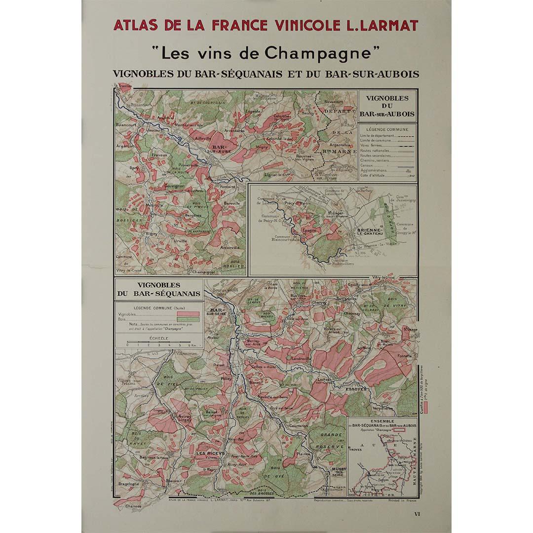
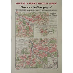
View All1944 original map Les vins de Champagne – Vignobles du Bar-Séquanais
Located in PARIS, FR
The 1944 original map "Atlas de la France Vinicole – Les vins de Champagne – Vignobles du Bar-Séquanais et du Bar-sur-Aubois", created by Louis Larmat and printed by Dorel in Paris, ...
Category
1940s Prints and Multiples
Materials
Lithograph, Paper
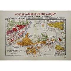
1946 original map "Les vins des côteaux de la Loire - Bourgueil" by Larmat
Located in PARIS, FR
The 1946 original map Atlas de la France Vinicole - Les Vins des Côteaux de la Loire: Bourgueil, St Nicolas-de-Bourgueil, Chinon, Montlouis, Jasnières, created by Louis Larmat and pr...
Category
1940s Prints and Multiples
Materials
Lithograph, Paper
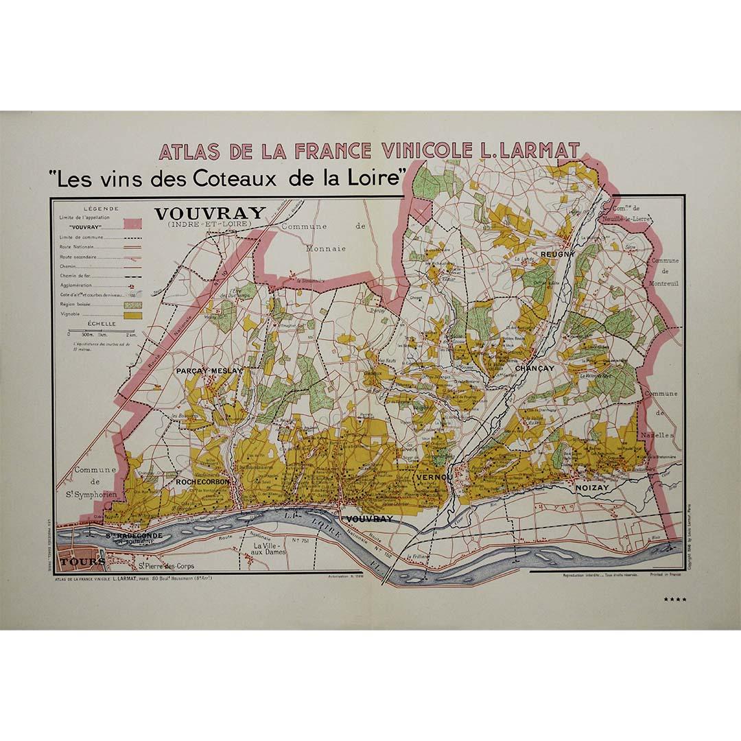
1946 original map "Les vins des côteaux de la Loire - Vouvray " by Larmat
Located in PARIS, FR
The 1946 map titled Atlas de la France Vinicole - Les Vins des Côteaux de la Loire: Vouvray by Louis Larmat, printed by Dorel in Paris, presents an intimate exploration of one of the...
Category
1940s Prints and Multiples
Materials
Lithograph, Paper

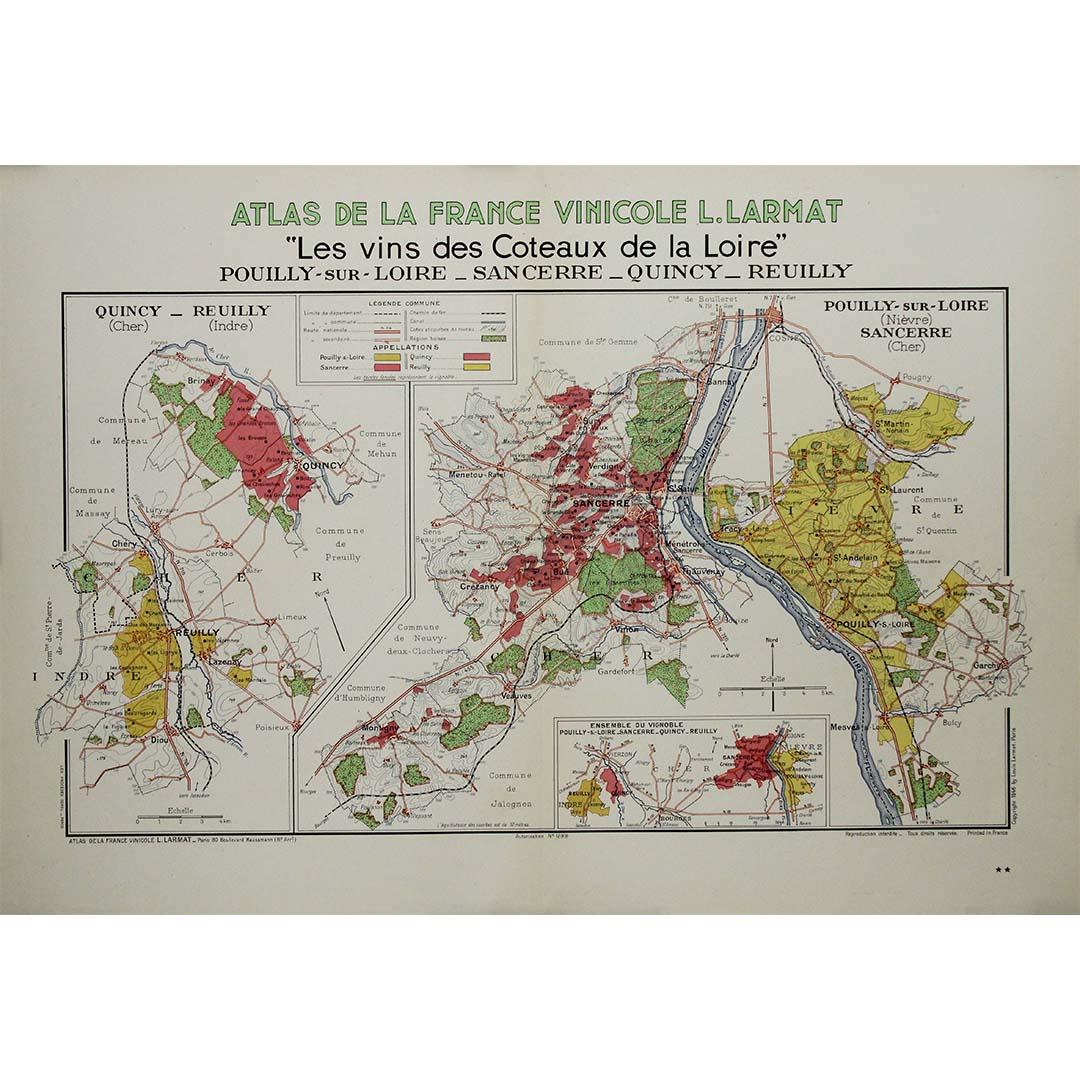
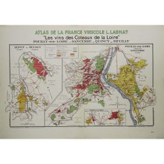
1946 original map "Les vins des côteaux de la Loire - Pouilly-sur-Loire" Larmat
Located in PARIS, FR
The 1946 original map Atlas de la France Vinicole - Les Vins des Côteaux de la Loire: Pouilly-sur-Loire, Sancerre, Quincy, Reuilly, created by Louis Larmat and printed by Dorel in Pa...
Category
1940s Prints and Multiples
Materials
Lithograph, Paper
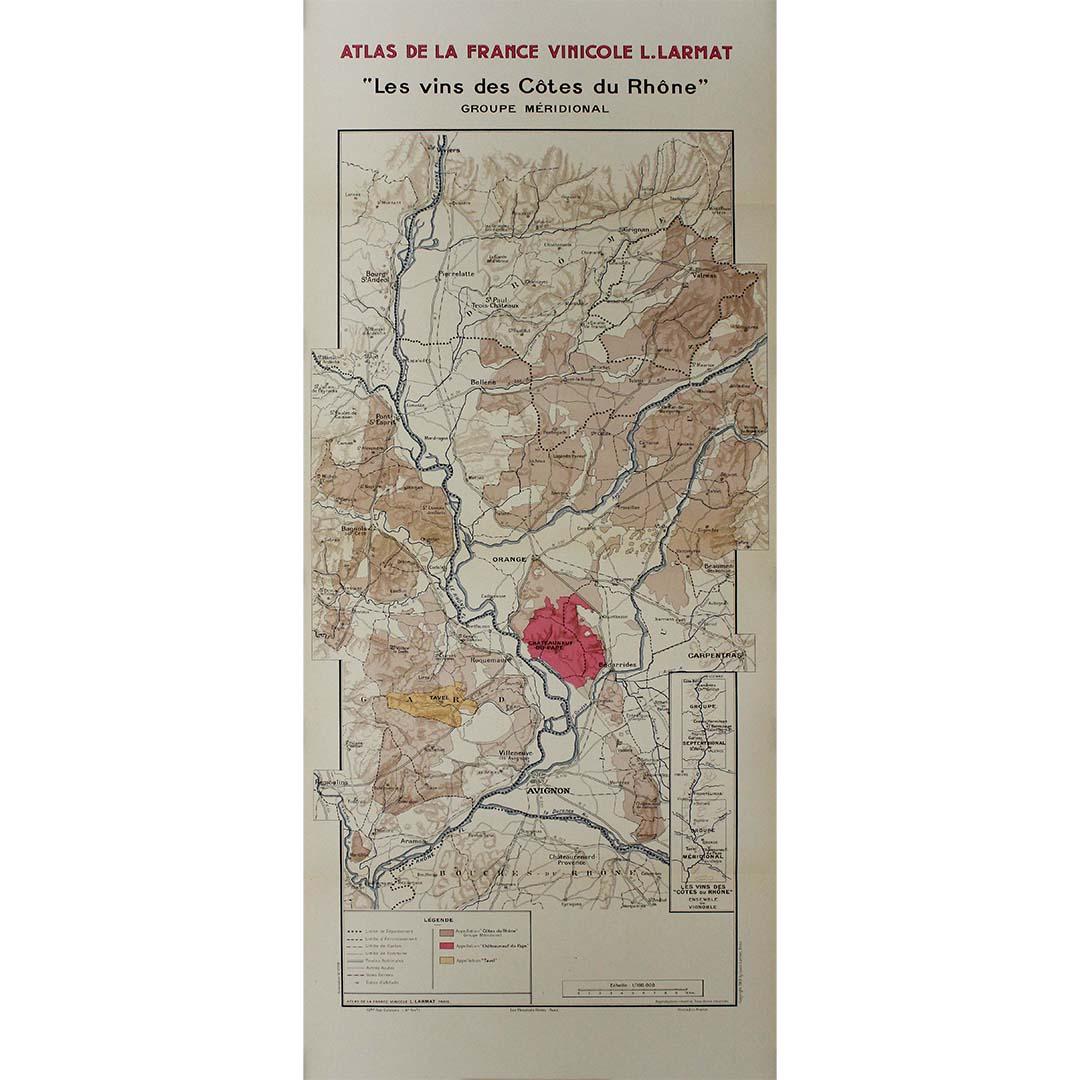
1943 original map "Les vins des Côtes du Rhône - Groupe Meridional"
Located in PARIS, FR
The 1943 original map by L. Larmat from the "Atlas de la France Vinicole" series, titled "Les vins des Côtes du Rhône - Groupe Méridional", is a significant cartographic depiction of...
Category
1940s Prints and Multiples
Materials
Lithograph, Paper

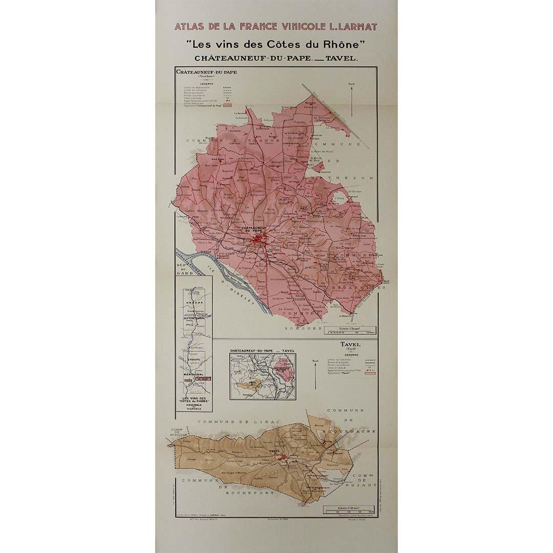
1943 original map "Les vins des Côtes du Rhône - Chateauneuf du Pape " by Larmat
Located in PARIS, FR
The 1943 original map by L. Larmat, titled "Les vins des Côtes du Rhône - Châteauneuf-du-Pape - Tavel", is an exquisite part of the "Atlas de la France Vinicole" series. Printed by D...
Category
1940s Prints and Multiples
Materials
Lithograph, Paper

You May Also Like
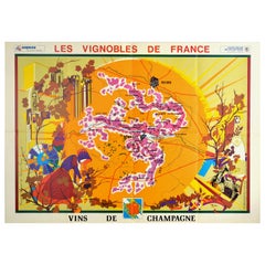
Original Vintage Poster Vineyards Of Champagne Wine Map Les Vignobles De France
Located in London, GB
Original vintage advertising poster for Les Vignobles de France Vins de Champagne / The Vineyards of France Wines of Champagne featuring a pictogra...
Category
Vintage 1960s French Posters
Materials
Paper
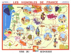
Original Vins du Sud-Ouest vintage French wine map poster
Located in Spokane, WA
Original Les Vignobles de France , Vins du Sud-Quest French vintage wine map poster. Horizontal. Size 36.5" x 27". Archival linen backed and re...
Category
Late 20th Century American Modern Landscape Prints
Materials
Lithograph
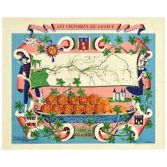
Original Vintage Poster Vignobles De France Vins Du Val De Loire Valley Wine Map
Located in London, GB
Original vintage drink advertising poster promoting French wines (one of a series issued by the Comite National de Propagande en Faveur du Vin national committee for the promotion of...
Category
Vintage 1950s French Posters
Materials
Paper
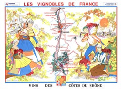
Original Vins Des Côtes du Rhône, French Wine Map vintage poster
Located in Spokane, WA
Original Les Vignobles de France - Cote du Rhone vintage wine map poster. Horizontal. Size 36.5" x 27". Archival linen backed and ready to fram...
Category
Late 20th Century American Modern Landscape Prints
Materials
Lithograph
$600 Sale Price
20% Off
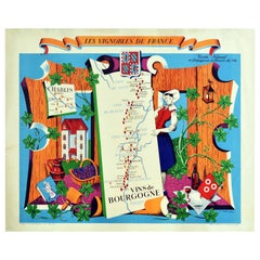
Original Vintage Poster Vignobles De France Vins De Bourgogne Burgundy Wine Map
Located in London, GB
Original vintage drink advertising poster promoting French wines (one of a series issued by the Comite National de Propagande en Faveur du Vin national committee for the promotion of...
Category
Vintage 1950s French Posters
Materials
Paper
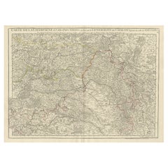
Antique Map of Champagne and surrounding Regions, France
Located in Langweer, NL
Antique map titled 'Carte de la Champagne et des Pays Voisins (..)'. Detailed map of Champagne and surrounding regions of Chalons and Soissons, Reims,...
Category
Antique Mid-18th Century Maps
Materials
Paper